

A Free Printable World Time Zone Map in PDF helps you understand time differences between countries, plan international meetings, organize travel, and learn how standard time zones work. This page provides printable world time zone maps in PDF and image formats, including maps showing countries, latitude, longitude, and standard time zones.
Choose the map that best suits your needs, download the available PDF, and print it for personal, educational, or professional reference.
Check these articles Too:-
- World Map Poster
- Labeled Map of World
- Blank Map of World
- World Map with Continents
- Labeled Map of South America
- Labeled Map of Africa
- Labeled Map of Europe
- Labeled Map of Africa
- Blank Map of Asia
- Physical World Map
- Political World Map
- World Map with oceans
- World Map Poster
- Labeled Map of Europe
World Time Zone Map
Use this world time zone map to explore how standard time is represented across different parts of the world. It can be useful for geography lessons, international communication, travel planning, and office reference.
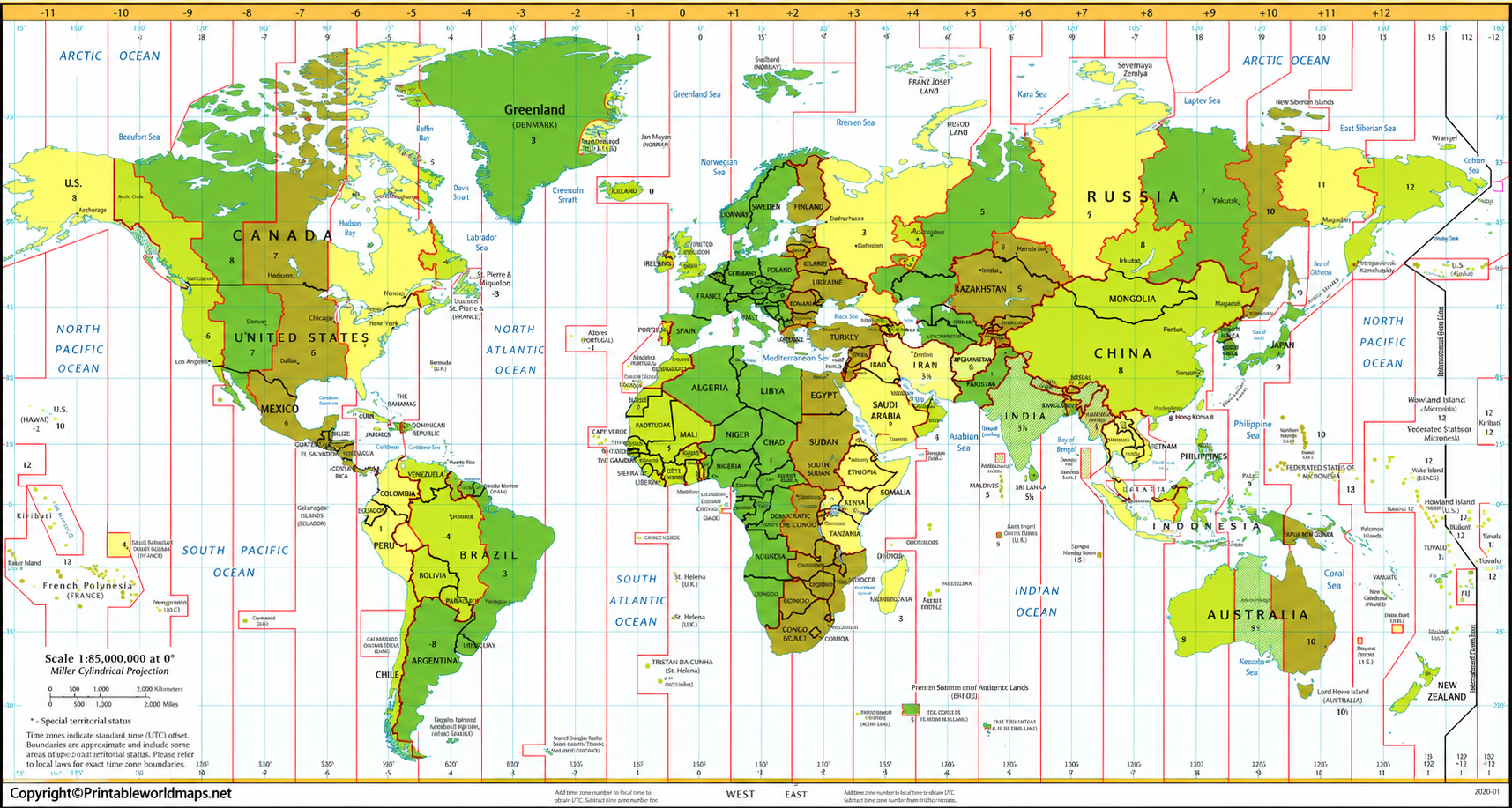
For the best printing results, open the PDF and check the page orientation and print preview before printing. A landscape layout may help preserve labels and geographical details, depending on the map’s page dimensions.
World Map with Time Zones
A world map with time zones provides a visual overview of the different timekeeping regions around the globe. It helps readers compare locations and understand why the local time in one country may differ from the time in another.
Time zone boundaries do not always follow straight lines of longitude. Governments establish official timekeeping rules, and boundaries may follow national or regional borders. Some countries also use more than one time zone.

This map can be used as a classroom resource, a study aid, or a quick visual reference when coordinating activities across different regions.
Time Zone Map World
A printable time zone map makes it easier to compare geographical regions without relying entirely on online tools. Depending on the map’s level of detail, it may show country names, time zone boundaries, reference meridians, or UTC offsets.
You can download the available maps, save them for offline use, or print them for personal and educational purposes. Remember that a static map is a general reference: it may not reflect recent changes to official time zone boundaries or daylight saving rules.
For current local times and upcoming clock changes, consult an up-to-date time zone resource alongside the printable map.
World Map with Time Zones and Latitude and Longitude
Latitude and longitude are geographical coordinates used to identify positions on Earth’s surface. Latitude measures distance north or south of the Equator, while longitude measures distance east or west of the Prime Meridian.
Longitude is relevant to understanding solar time. As a general geographical approximation, Earth rotates 360 degrees in about 24 hours, equivalent to 15 degrees of longitude per hour. However, official time zones are determined by governments and do not necessarily follow these theoretical divisions.

This map can help students compare geographical coordinates with time zone patterns and understand the relationship between longitude and local time.
Standard Time Zones of the World Map
Coordinated Universal Time (UTC) is the international reference used to express time differences worldwide. Local time zones are commonly described by their offsets from UTC, such as UTC+5:30 or UTC−4.
The familiar model divides Earth into 24 theoretical one-hour zones. Actual civil timekeeping is more complicated: countries can choose their own offsets, and some locations use half-hour or 45-minute differences. Daylight saving time can also change a region’s offset during part of the year.

Use this map to study the general arrangement of standard time zones. For official current offsets and daylight saving rules, verify the relevant location using an authoritative time zone database.
World Map with Time Zones and Countries
A world map showing time zones and countries combines geographical boundaries with timekeeping information. It can help readers locate countries, compare regions, and understand how international time differences affect communication and travel.
Not every country uses a single time zone. For example, several large countries have multiple official time zones, while others use one standard time nationwide. The time shown on a map may also depend on whether daylight saving time is observed.

Before using this map for travel, business scheduling, or other time-sensitive tasks, confirm the current local time for the specific city or region.
How to Read a World Time Zone Map
Follow these steps to read a time zone map:
- Locate the place: Find the country, city, or geographical region you want to check.
- Identify its time zone: Look for the boundary, label, or UTC offset shown on the map.
- Check the UTC offset: A positive offset means local time is ahead of UTC; a negative offset means it is behind UTC.
- Consider the date: Some locations change their clocks seasonally because of daylight saving time.
- Verify the local rules: Use a current time zone reference if you need an accurate time for a meeting, flight, or appointment.
A printed map is excellent for understanding the general pattern of time zones, but it should not be treated as a live clock or a guarantee of current local time.
Interesting Facts About World Time Zones
- UTC is the global reference: Time differences are commonly expressed as offsets from Coordinated Universal Time.
- There are more than 24 UTC offsets: Some locations use offsets that differ by 30 or 45 minutes rather than whole hours.
- India uses UTC+5:30: Indian Standard Time is five hours and thirty minutes ahead of UTC.
- Time zone boundaries are political as well as geographical: They may follow national borders, regional boundaries, or government decisions rather than exact longitude lines.
- Daylight saving time is not universal: Some locations change their clocks seasonally, while others maintain the same standard offset throughout the year.
- Time zone rules can change: Governments may change their official offsets or daylight saving policies, so reference data needs periodic updates.
These facts make world time zone maps useful for geography education, international business, travel preparation, and general awareness.
Why Use a Printable World Time Zone Map?
A printable world time zone map offers several practical benefits:
- Education: Helps students learn about global geography and time differences.
- Travel planning: Provides a broad overview of time zones before an international trip.
- International business: Helps teams visualize the locations of colleagues, customers, and business partners.
- Offline reference: A downloaded PDF can be viewed or printed without an active internet connection.
- Home or office use: A printed map can serve as a convenient geographical reference.
For exact meeting times and travel schedules, always confirm the relevant city’s current time rather than relying only on a printed map.
How to Download and Print the World Time Zone Map
- Choose your preferred map from the sections above.
- Open the PNG image to view the map or open the PDF link to access the printable file.
- Save the file to your device using your browser’s download option.
- Open the PDF in a PDF reader and check the print preview.
- Select a suitable paper size and orientation based on the file’s dimensions.
- Use a print quality setting that keeps country names and time zone labels readable.
If labels appear too small, try printing on larger paper or using a higher-resolution file when available.
Frequently Asked Questions
1. Where can I download a free printable world time zone map in PDF?
You can download the maps linked in this article. Available options include a general world time zone map, a map with latitude and longitude, a standard time zone map, and a map showing countries.
2. What is a world time zone map used for?
A world time zone map helps readers compare timekeeping regions and understand differences in local time. It is useful for education, international communication, travel planning, and business coordination.
3. What does UTC mean on a time zone map?
UTC stands for Coordinated Universal Time. It is the reference standard used to express local time differences around the world. For example, UTC+5:30 means the local time is five hours and thirty minutes ahead of UTC.
4. Does every country have only one time zone?
No. Some countries use multiple time zones because of their geographical size or official timekeeping arrangements. Other countries use a single national time zone.
5. Why are there more than 24 time offsets?
The 24-zone model is a theoretical simplification based on one-hour differences. In practice, some locations use offsets of 30 or 45 minutes, and official time zone boundaries do not always follow the theoretical divisions.
6. Do world time zone maps show daylight saving time?
Some maps include daylight saving information, but others show only standard time zones. Because daylight saving rules can change local offsets, check a current source for the location and date you need.
7. Is a printable time zone map always up to date?
Not necessarily. A static map may become outdated when governments change time zone boundaries or clock rules. Use an up-to-date time zone database or a current local time service for time-sensitive decisions.
8. What is the difference between UTC and GMT?
UTC is the internationally coordinated time standard used as the reference for civil timekeeping. GMT is a time designation associated with Greenwich and is often used informally as equivalent to UTC for everyday purposes, although the terms have different technical histories and definitions.
9. Can I use a printable world time zone map for school projects?
Yes. It can be used as a visual reference for geography assignments, classroom displays, and projects about longitude and global time differences. Check your school’s requirements and the map’s usage terms before reproducing it in published work.
10. What is the best way to check the current time in another country?
Identify the specific city or region and check its current local time using a reliable time service or current time zone database. Checking the date is important because some locations observe daylight saving time.
Reference links
https://www.iana.org/time-zones
https://www.iana.org/time-zones/releases
https://www.nist.gov/pml/time-and-frequency-division/time-realization
https://www.timeanddate.com/time/utc-offsets.html
https://www.timeanddate.com/time/current-number-time-zones.html

34 thoughts on “Free Printable World Time Zone Map in PDF”