
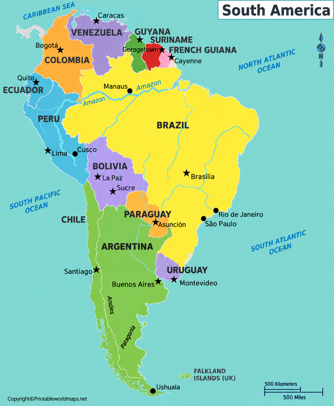

A labeled map of South America is a useful resource for learning the continent’s countries, capital cities, major rivers, and important geographical features. Whether you are a student preparing for a geography exam, a teacher creating classroom activities, or someone exploring world geography, a printable map makes these locations easier to understand.
On this page, you can explore labeled maps of South America featuring country names, capitals, and major cities. Download the available PDF maps, print them for study, or use them as a reference while learning about the continent.
You can also explore our blank map of South America to practise identifying countries and geographical boundaries without labels.
Labeled Map of South America
South America is the fourth-largest continent by land area. It lies mainly in the Southern Hemisphere, although its northern portion extends across the Equator into the Northern Hemisphere. The Pacific Ocean borders the continent to the west, while the Atlantic Ocean lies to the east. The Caribbean Sea borders parts of its northern coastline.
A labeled map helps readers understand the continent’s position, national boundaries, surrounding oceans, and general geographical layout.
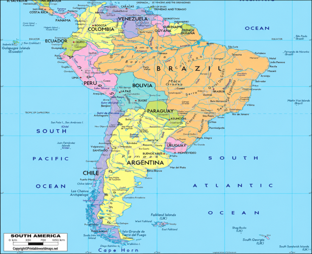
Use this map for geography lessons, revision, school assignments, and personal reference. Before printing, check the PDF’s page orientation and print settings to ensure that country names and labels remain readable.
Labeled South America Map with Countries
A labeled South America map with countries identifies the continent’s 12 sovereign countries and helps readers understand their relative positions and shared borders.
The 12 independent countries are:
- Argentina
- Bolivia
- Brazil
- Chile
- Colombia
- Ecuador
- Guyana
- Paraguay
- Peru
- Suriname
- Uruguay
- Venezuela
French Guiana is also located in South America, but it is an overseas department and region of France rather than an independent country. The Falkland Islands and South Georgia and the South Sandwich Islands are UK-administered overseas territories that are also claimed by Argentina.
Brazil is the largest country in South America by land area and population. Chile extends along much of the continent’s Pacific coast, while Argentina occupies a large part of the southern region. Smaller countries, including Uruguay, Suriname, and Guyana, are also important parts of the continent’s geographical diversity.
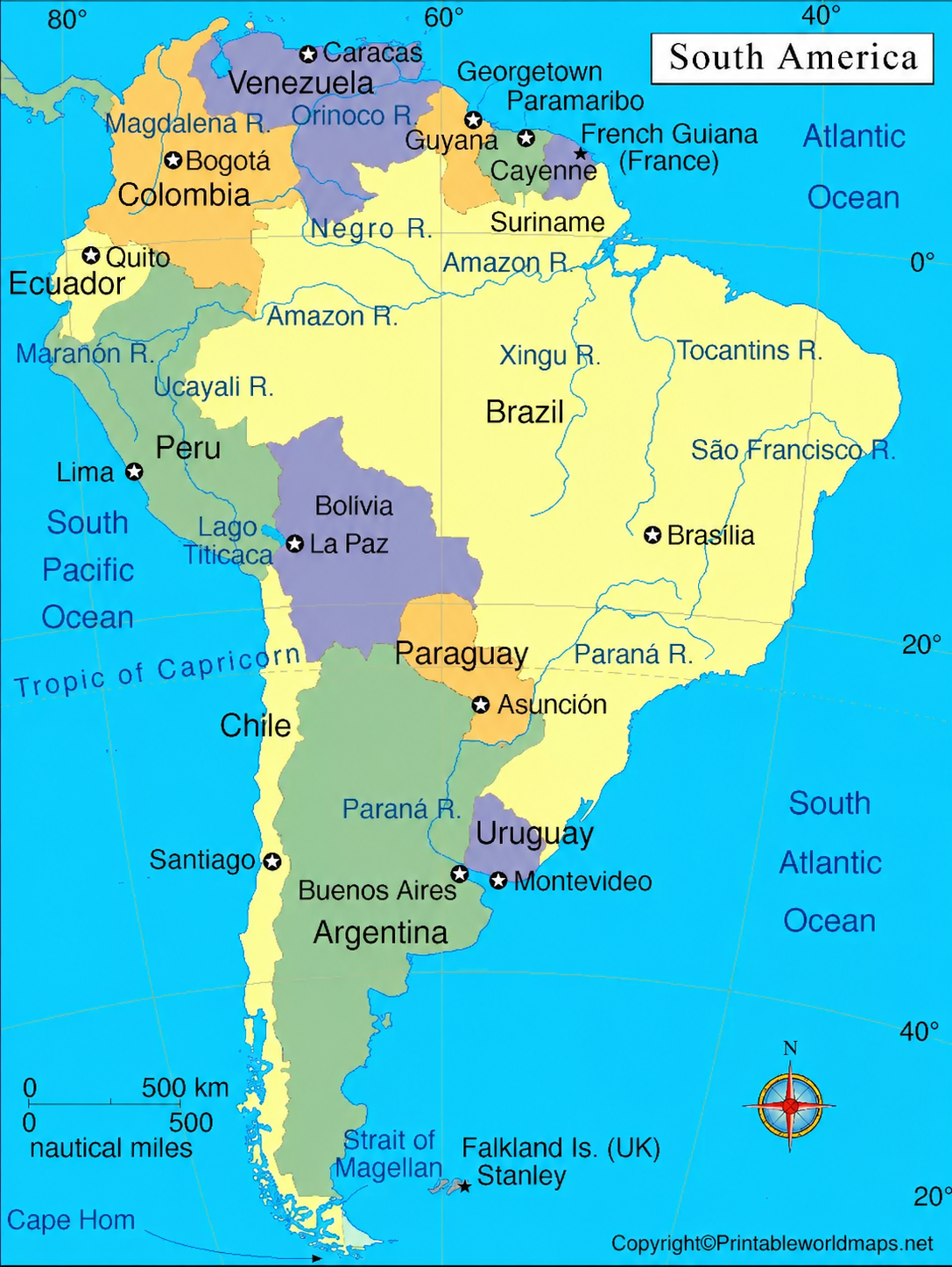
This map is useful for identifying country locations, learning neighboring countries, and practising map-based geography questions.
Labeled South America Map with Capitals
A labeled South America map with capitals makes it easier to connect each country with its capital city. Capital locations are especially useful for school assignments, quizzes, and general knowledge activities.
Here is a reference list of the countries and their capitals:
| Country | Capital |
|---|---|
| Argentina | Buenos Aires |
| Bolivia | Sucre (constitutional capital); La Paz (seat of government) |
| Brazil | Brasília |
| Chile | Santiago |
| Colombia | Bogotá |
| Ecuador | Quito |
| Guyana | Georgetown |
| Paraguay | Asunción |
| Peru | Lima |
| Suriname | Paramaribo |
| Uruguay | Montevideo |
| Venezuela | Caracas |
French Guiana’s capital and prefecture is Cayenne. It is not included in the list of 12 sovereign countries because French Guiana is part of France.
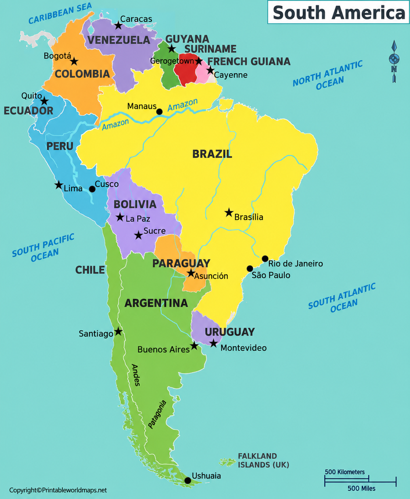
For a more effective study session, locate each capital on the map and then identify the country around it. Pay particular attention to Brasília, Bogotá, Buenos Aires, Lima, Santiago, and Quito, which are useful reference points when learning the continent’s geography.
South America Map with Major Rivers
South America has extensive river systems that influence its ecosystems, agriculture, transport, and settlement patterns. A physical or labeled river map can help readers understand how rivers connect different parts of the continent.
Amazon River
The Amazon River system drains a vast area of northern South America and flows eastward toward the Atlantic Ocean. The Amazon Basin includes parts of several countries and contains extensive tropical rainforest ecosystems.
Paraná River
The Paraná River flows through or along parts of Brazil, Paraguay, and Argentina. Together with other rivers in the Río de la Plata drainage system, it is important for freshwater resources, transport, and hydroelectric power.
Orinoco River
The Orinoco River flows mainly through Venezuela and forms part of the natural drainage system of northern South America. Its basin includes extensive tropical grasslands and wetlands.
Río de la Plata
The Río de la Plata is a large estuary formed by the Paraná and Uruguay river systems along the coasts of Argentina and Uruguay.
For additional study, explore our South America rivers map. Comparing a country map with a river map can help you understand how physical geography relates to political boundaries.
South America Map with Cities Labeled
A South America map with cities labeled helps readers locate major urban centres as well as national capitals. Cities are important reference points for understanding population distribution, transport connections, trade, and regional development.
Some major cities to identify include:
- São Paulo, Brazil: A major financial, industrial, and cultural centre.
- Rio de Janeiro, Brazil: Known for its coastal setting and cultural landmarks.
- Buenos Aires, Argentina: The country’s capital and a major metropolitan centre.
- Lima, Peru: Peru’s capital, located on the Pacific coast.
- Bogotá, Colombia: Colombia’s capital, situated in the Andes.
- Caracas, Venezuela: Venezuela’s capital in the country’s northern region.
- Santiago, Chile: Chile’s capital, located in a valley near the Andes.
The population of a city depends on whether the source measures the city proper, urban area, or metropolitan area. For this reason, avoid comparing city population figures without checking that they use the same definition and reference year.

Important Geography Facts About South America
These facts provide additional context when studying a labeled map of South America.
- Twelve sovereign countries: South America contains 12 independent countries. French Guiana is a French overseas department located on the continent.
- The Andes Mountains: The Andes extend along the western side of South America and form the world’s longest continental mountain range.
- The Amazon Basin: This enormous drainage basin supports extensive tropical rainforest ecosystems and contains a vast network of rivers and tributaries.
- The Equator crosses northern South America: Ecuador, Colombia, and Brazil are among the countries crossed by the Equator.
- Two major oceans: The Pacific Ocean borders the west coast, while the Atlantic Ocean borders the east coast.
- Different languages: Spanish and Portuguese are widely spoken, while Dutch, English, Indigenous languages, and French are also spoken in different parts of the continent.
- Diverse landscapes: South America includes tropical rainforests, high mountains, grasslands, deserts, plateaus, wetlands, and glacial landscapes.
These geographical features explain why South America is an important region for studying climate, biodiversity, physical geography, and human settlement.
How to Use a Printable South America Map
A printable map can be used in several practical ways:
- For students: Learn country names, capitals, borders, and surrounding oceans.
- For teachers: Prepare classroom worksheets, geography quizzes, and map-labeling exercises.
- For exam preparation: Practise identifying countries and capitals without looking at a reference list.
- For travel planning: Use a country map as a starting point for understanding the continent’s geography before consulting detailed road or transport maps.
- For home learning: Print the map and label countries, capitals, mountain ranges, and rivers with different coloured pencils.
For the best results, select a PDF with clear labels and suitable page dimensions. If small country names are difficult to read, print on larger paper or use the PDF’s zoom function.
Frequently Asked Questions
How many countries are there in South America?
South America has 12 sovereign countries: Argentina, Bolivia, Brazil, Chile, Colombia, Ecuador, Guyana, Paraguay, Peru, Suriname, Uruguay, and Venezuela.
Is French Guiana a country?
No. French Guiana is an overseas department and region of France located on the northeastern coast of South America.
What is the largest country in South America?
Brazil is the largest country in South America by both land area and population.
What is the capital of South America?
South America is a continent, not a country, so it does not have a single capital. Each sovereign country has its own capital.
What are the capitals of South American countries?
The capitals are Buenos Aires, Sucre, Brasília, Santiago, Bogotá, Quito, Georgetown, Asunción, Lima, Paramaribo, Montevideo, and Caracas. Bolivia’s seat of government is in La Paz, while Sucre is its constitutional capital.
Where can I download a labeled map of South America in PDF format?
You can download the maps linked in this article, including versions showing country names, capitals, and major cities. Check the individual PDF before printing to confirm which labels it includes.
What is the difference between a labeled and a blank map?
A labeled map includes information such as country names, capitals, or geographical features. A blank map leaves some or all of these labels out, making it useful for practice and classroom exercises.
Which oceans border South America?
The Pacific Ocean lies to the west, and the Atlantic Ocean lies to the east. The Caribbean Sea borders parts of the continent’s north coast.
Reference links
https://www.un.org/geospatial/file/2567/download?token=YdpDEbiY
https://education.nationalgeographic.org/resource/south-america-physical-geography/
https://education.nationalgeographic.org/resource/south-america-human-geography/
https://data.un.org/legacy/en/iso/br.html
https://data.un.org/legacy/en/iso/bo.html
https://datahelpdesk.worldbank.org/knowledgebase/articles/898590-country-api-queries
South America Map PDF
A free South America map with all the cities labeled is a great tool for teachers, researchers, or students. You can download any map from this page free of charge as a PDF file and print as many copies as you need. You might also want to use these maps as a poster for a classroom wall, for homework assignments or in exams.
Get your South America labeled map and combine it with a blank map of South America or a labeled physical map of South America. Together, these will help you to teach your class about the geography of South America including the Andes mountains, the Amazon basin and other important features.
Other Free Printable Maps to Download
Below you’ll find some links to other maps that might be useful or interesting. You can also explore more maps via our search feature. If none of our maps suits your needs, please get in touch via our contact form. Our team will do their best to find or create any missing map and make it available.
Finally, we also offer ready-made but editable geography worksheets as well as wall maps and other geography resources.
World Maps
- World Map With Continents
- Blank Map of the World
- Political World Map
- Physical World Map
- World Map with Oceans
- World Map Poster
Continent Maps
Blank Maps of Countries
- Blank Map of South Africa
- Ukraine Blank Map
- New Zealand Blank Map
- Blank Map of France
- China Blank Map
- Italy Blank Map

49 thoughts on “Labeled Map of South America with Countries in PDF”