
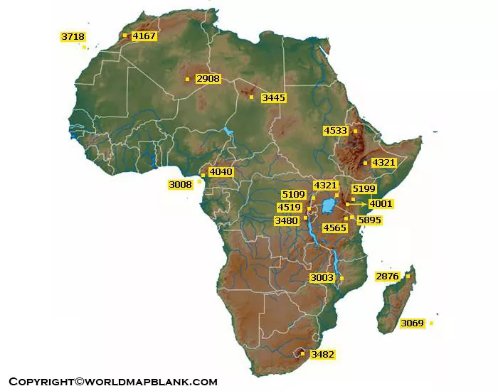
Explore the physical geography of Africa with our Africa Mountains Map collection. These printable maps show major mountain regions, prominent peaks, and mountain ranges across the African continent.
The maps are useful for students, teachers, geography researchers, travelers, and anyone studying African physical geography. You can view the maps online or download the available PNG and PDF versions for printing and classroom use.
Africa Mountains Map
Africa is basically the world’s second-large continent both in the terms of size and population as well. The continent contains about 20% of the total earth’s land area and 16% of the population. The African continent is known for its super-rich natural resources yet the least economic growth.
Africa is the world’s second-largest continent by both land area and population, after Asia. Its physical geography includes deserts, plateaus, highlands, mountains, river systems, tropical forests, and coastal regions.
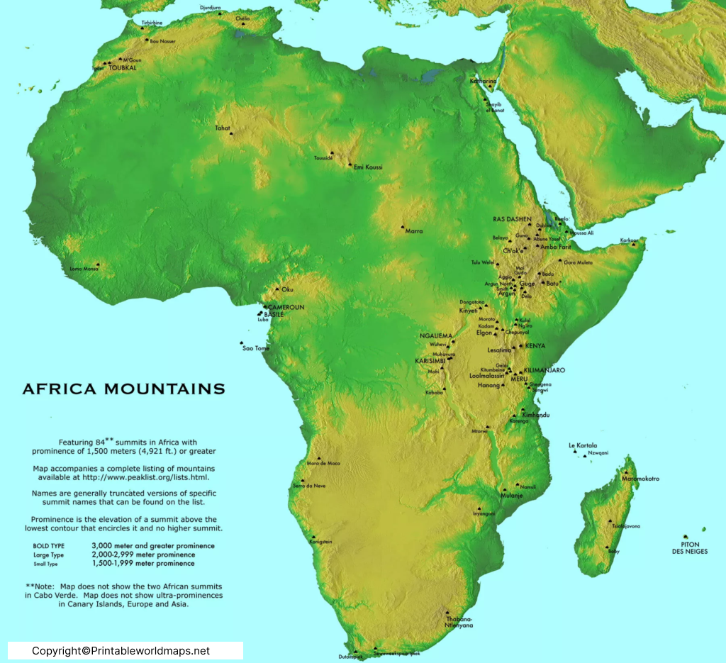
Major Mountain Regions in Africa
Africa’s major mountainous areas include the Atlas Mountains in northwestern Africa, the Ethiopian Highlands in eastern Africa, the East African mountain systems, and the Drakensberg Mountains in southern Africa.
Some of the continent’s highest elevations are concentrated in eastern Africa, including Mount Kilimanjaro, Mount Kenya, and the Rwenzori Mountains.
Africa Map with Mountains
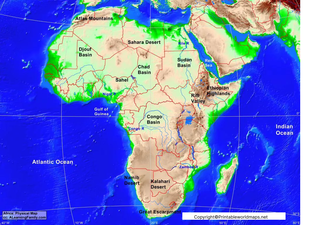
The Africa Map with Mountains provides a broader physical-geography view of the continent and helps users identify mountainous areas in relation to surrounding countries and regions.
Why Are Africa’s Mountains Important?
Africa’s mountain environments influence climate, rainfall, water resources, ecosystems, agriculture, tourism, and human settlement.
Several important rivers and watersheds are associated with African highlands. Mountain environments also contain distinctive ecosystems and support species adapted to high-elevation conditions.
Map of Africa Mountains
The Map of Africa Mountains helps readers locate major mountainous regions across the continent. It can be used as a reference when studying Africa’s physical geography and topography.
Highest Mountain in Africa
Mount Kilimanjaro, located in Tanzania, is the highest mountain in Africa. Its highest point, Uhuru Peak, reaches approximately 5,895 metres (19,341 feet) above sea level.
Kilimanjaro is a volcanic mountain composed of three main volcanic cones: Kibo, Mawenzi, and Shira. Kibo contains Uhuru Peak, the continent’s highest point.
Other notable high mountains include:
- Mount Kenya — Kenya
- Mount Stanley — Uganda/DR Congo
- Mount Speke — Uganda
- Mount Baker — Uganda
- Mount Meru — Tanzania
- Ras Dashen — Ethiopia
Printable Africa Mountains Map Labeled
This Printable Africa Mountains Map Labeled template is designed to make the continent’s mountain geography easier to study.
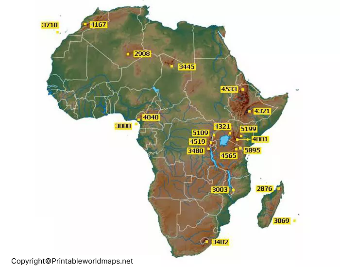
A labeled map can be useful for geography assignments, classroom activities, revision, presentations, quizzes, and personal study.
You can print the map or use the digital version on a computer, tablet, or other device.
Major African Mountain Ranges and Regions
| Mountain range / region | Location | Notable feature |
|---|---|---|
| Atlas Mountains | Morocco, Algeria, Tunisia | Major mountain system of northwestern Africa |
| Ethiopian Highlands | Ethiopia and surrounding region | Extensive highland area in eastern Africa |
| Rwenzori Mountains | Uganda & DR Congo | High mountain range near the Albertine Rift |
| East African volcanic mountains | Kenya & Tanzania | Includes Kilimanjaro and Mount Kenya |
| Drakensberg | South Africa & Lesotho | Major mountain system of southern Africa |
| Ahaggar Mountains | Algeria | Mountain massif in the central Sahara |
| Tibesti Mountains | Chad & Libya | Major Saharan mountain system |
Africa Mountains Map: Geography Facts
Here are some useful facts to remember when studying the Africa Mountains Map:
- Mount Kilimanjaro is Africa’s highest mountain.
- Kilimanjaro is located in northeastern Tanzania.
- Mount Kenya is the second-highest mountain in Africa.
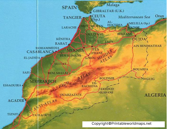
- The Atlas Mountains extend across parts of Morocco, Algeria, and Tunisia.
- The Drakensberg is a major mountain system of southern Africa.
- The Rwenzori Mountains are located along the Uganda–Democratic Republic of the Congo border.
- Africa’s eastern highlands are closely associated with the East African Rift System.
- Mountain areas can create significant differences in rainfall, temperature, vegetation, and local ecosystems.
How to Use the Printable Africa Mountains Map
The maps can be used for several educational purposes:
1. Geography Study
Identify major mountain systems and their locations.
2. Classroom Activities
Teachers can use the labeled and printable versions for geography lessons.
3. Map Practice
Students can compare mountain locations with countries, rivers, lakes, and surrounding physical features.
4. Assignments & Projects
The maps can provide a visual reference for Africa geography projects.
5. Revision
Use a blank or printable version to practice identifying important mountain regions.
Africa Mountains Map PDF and PNG
The maps are available in PNG and PDF formats. PNG files are convenient for viewing digitally, while PDF versions are useful when a printable document is preferred.
Before printing, check the map dimensions and printer settings to ensure labels remain readable.
Frequently Asked Questions
What is the Africa Mountains Map?
The Africa Mountains Map is a physical-geography reference showing major mountain areas, ranges, and prominent elevations across Africa.
What is the highest mountain in Africa?
Mount Kilimanjaro in Tanzania is the highest mountain in Africa, with Uhuru Peak reaching approximately 5,895 metres (19,341 feet).
Where are the Atlas Mountains located?
The Atlas Mountains are primarily located in Morocco, Algeria, and Tunisia in northwestern Africa.
What are the major mountain ranges in Africa?
Important mountain systems and regions include the Atlas Mountains, Ethiopian Highlands, Rwenzori Mountains, Drakensberg, Ahaggar Mountains, and Tibesti Mountains.
Where is Mount Kenya located?
Mount Kenya is located in central Kenya and is the second-highest mountain in Africa.
What is the Rwenzori Mountains range?
The Rwenzori Mountains are a high mountain range along the Uganda–Democratic Republic of the Congo border. The range includes Mount Stanley, whose highest summit is Margherita Peak.
Can I print the Africa Mountains Map?
Yes. The provided map resources include PNG and PDF versions, making them suitable for digital viewing and printing.
Who can use an Africa Mountains Map?
Students, teachers, researchers, geography enthusiasts, travelers, and anyone studying African physical geography can use the map as a visual reference.
What is the difference between an Africa Mountains Map and a political map?
A political map primarily shows countries and boundaries, while a mountains or physical map focuses on terrain, elevation, mountain systems, and other natural geographic features.
Reference link
https://www.britannica.com/place/Africa
https://www.britannica.com/place/Mount-Kilimanjaro
https://earthobservatory.nasa.gov
More Free Maps for Download
Here are some useful links to other printable world maps, continent maps and country maps for download as PDF files.
World Maps
- Labeled World Map
- Time Zone World Map
- Printable World Map Poster
- World Map with Continents
- Physical World Map
- Political World Map
Continent Maps
- Africa Map with Countries
- Labeled Map of South America
- Blank Map of Asia
- Labeled Map of Europe
- Physical Map of Australia
- Blank Map of South America
- Blank Map of Europe









