
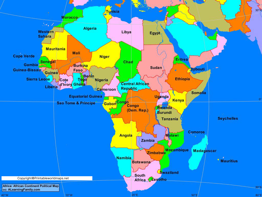

Africa Map with Countries is a useful reference for learning the geography of the African continent. This collection includes labeled maps showing African countries, country names, capitals, major rivers, and other important geographic features.
You can use these Africa maps for geography lessons, classroom activities, homework, presentations, travel planning, research, and general reference. The maps are available in printable formats so they can be downloaded and used for educational or personal purposes.
Last reviewed: August 2026
Geographic scope: Africa
UN-recognized African states: 54
African Union member states: 55
Africa is a geographically diverse continent extending from the Mediterranean Sea in the north to the southern tip of the continent and bordered by the Atlantic Ocean to the west and the Indian Ocean to the east and southeast.
Contents
- Labeled Map of Africa
- Africa Map with Countries
- How Many Countries Are in Africa?
- Africa Map With Capitals
- List of African Countries and Capitals
- Largest and Smallest Countries in Africa
- Africa Population Facts
- Africa Map With Rivers
- Major Rivers of Africa
- African Regions
- Interesting Facts About Africa
- How to Use an Africa Map
- Frequently Asked Questions
- References
Labeled Map of Africa
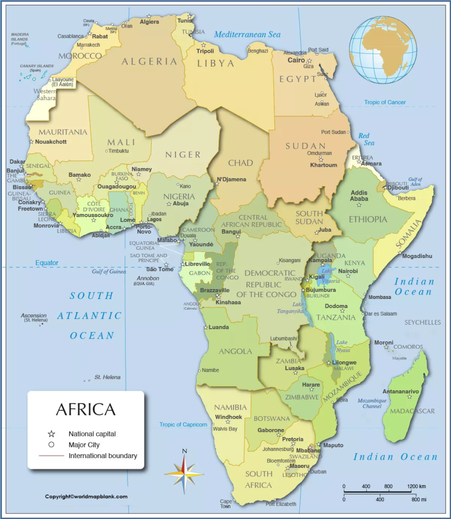
Our Africa Map with Countries shows the political geography of the continent with country boundaries and country names.
A labeled map is especially useful for identifying the location of countries and understanding how African nations are positioned relative to one another.
For the best learning experience, compare the labeled map with a blank Africa map. Students can first study the labeled version and then test their knowledge by filling in country names on the blank map.
How Many African Countries Are There?
There are 54 nations in Africa that are members of the United Nations and the African Union. These countries are fully recognized sovereign states. However, there are also two countries with limited international recognition: Somaliland and Western Sahara.
What Is the Largest African Country?
The largest country in Africa is Algeria with an area of 919,595 square miles (approx. 2.38 million square kilometers). Following closely behind is the Democratic Republic of Congo, measuring in at 905,355 square miles (2.34 million square kilometers). Third place goes to Sudan with an area of 718,723 square miles (1.86 million square kilometers).
| Rank | Country | Approx. Area |
|---|---|---|
| 1 | Algeria | 2.38 million km² |
| 2 | Democratic Republic of the Congo | 2.34 million km² |
| 3 | Sudan | 1.86 million km² |
| 4 | Libya | 1.76 million km² |
| 5 | Chad | 1.28 million km² |
| 6 | Niger | 1.27 million km² |
| 7 | Angola | 1.25 million km² |
| 8 | Mali | 1.24 million km² |
| 9 | South Africa | 1.22 million km² |
| 10 | Ethiopia | 1.10 million km² |
Area figures can vary slightly between sources depending on whether inland waters and territorial definitions are included.
What is the smallest country in Africa?
The Seychelles is the smallest country in Africa by land area.
Seychelles is an island country in the western Indian Ocean consisting of numerous islands northeast of Madagascar.
It is also one of Africa’s smallest countries by population.
Other relatively small African countries include São Tomé and Príncipe, Mauritius, Comoros, Cabo Verde, and The Gambia.
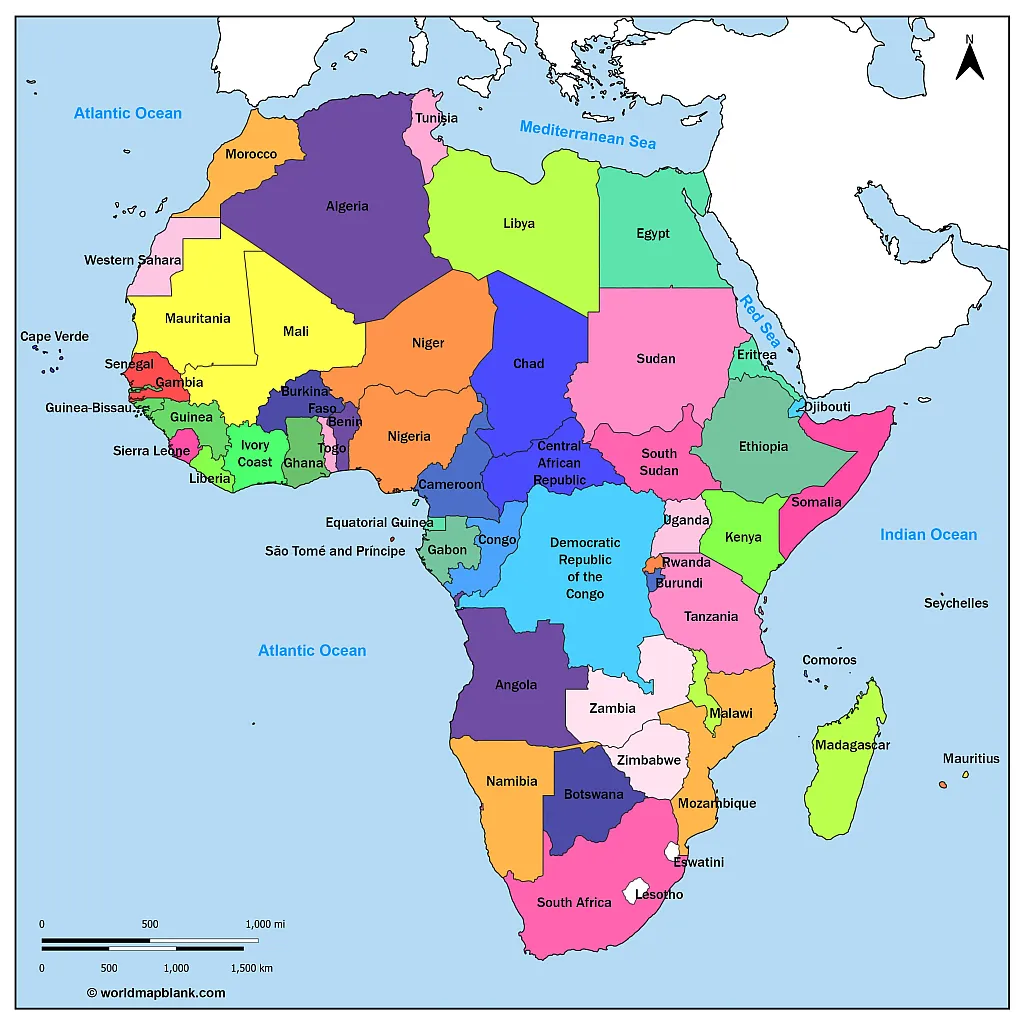
Africa Map with Countries
The African continent is bounded by the Mediterranean Sea to the north, the Red Sea to the northeast, the Indian Ocean to the southeast, and the Atlantic Ocean to the west. It is the second-largest continent in the world with a total area of 11.7 million square miles (30.2 million square kilometers).
Here is a map of African countries that shows all the nations of Africa but not their capitals:
As of 2025, Africa’s population is estimated to be approximately 1.484 billion people, accounting for about 17% of the world’s population, making it the second most populous continent after Asia.
The continent continues to experience rapid population growth, with an annual growth rate of approximately 2.5%. This growth is accompanied by a notably young demographic, with a median age of 19.7 years. (Source)
Urbanization in Africa is also on the rise. As of 2025, approximately 44% of the African population resides in urban areas, indicating a significant shift towards urban living. (Source)
These trends highlight the dynamic demographic changes occurring across the continent, presenting both opportunities and challenges for sustainable development, infrastructure planning, and economic growth.
Africa Map With Capitals
Africa contains 54 countries that are members of the United Nations African regional group. The African Union, however, has 55 member states, because its membership includes the Sahrawi Arab Democratic Republic, commonly associated with Western Sahara. (Ask UN)
This distinction is important when answering the question, “How many countries are in Africa?”
The safest way to state it is:
- 54 African countries are UN member states.
- 55 states are members of the African Union.
- Western Sahara/Sahrawi Arab Democratic Republic is the reason for the difference between the two figures.
Political maps may also differ in how they depict disputed territories, so map users should check the map’s legend and source when political boundaries are important.
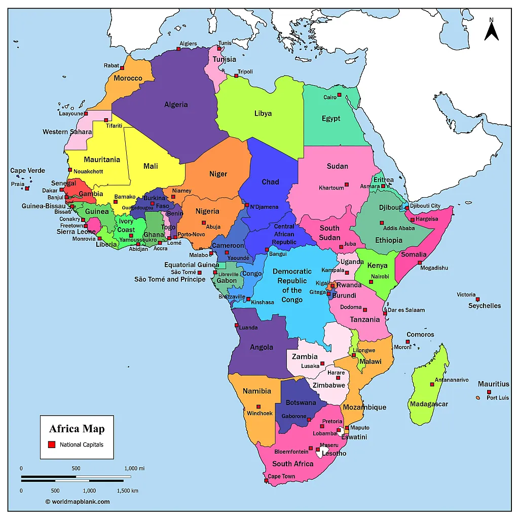
Please note that the above Africa map with names of countries is older and does not include South Sudan or other newly independent territories.
What Are the African Countries?
As of 2025, Africa’s population has experienced significant growth, with many countries seeing notable increases. Below is an updated overview of African countries, their capitals, and estimated populations:
| Country | Capital City | Estimated Population (2025) |
|---|---|---|
| Algeria | Algiers | 46,800,000 |
| Angola | Luanda | 37,000,000 |
| Benin | Porto-Novo | 15,000,000 |
| Botswana | Gaborone | 2,500,000 |
| Burkina Faso | Ouagadougou | 26,000,000 |
| Burundi | Gitega | 15,000,000 |
| Cabo Verde | Praia | 600,000 |
| Cameroon | Yaoundé | 30,000,000 |
| Central African Republic | Bangui | 6,000,000 |
| Chad | N’Djamena | 20,000,000 |
| Comoros | Moroni | 1,000,000 |
| Democratic Republic of Congo | Kinshasa | 108,000,000 |
| Republic of Congo | Brazzaville | 6,000,000 |
| Djibouti | Djibouti City | 1,200,000 |
| Egypt | Cairo | 117,000,000 |
| Equatorial Guinea | Malabo | 2,000,000 |
| Eritrea | Asmara | 7,000,000 |
| Eswatini | Mbabane | 1,300,000 |
| Ethiopia | Addis Ababa | 133,000,000 |
| Gabon | Libreville | 2,500,000 |
| Gambia | Banjul | 3,000,000 |
| Ghana | Accra | 36,000,000 |
| Guinea | Conakry | 16,000,000 |
| Guinea-Bissau | Bissau | 2,500,000 |
| Ivory Coast | Yamoussoukro | 30,000,000 |
| Kenya | Nairobi | 56,000,000 |
| Lesotho | Maseru | 2,500,000 |
| Liberia | Monrovia | 6,000,000 |
| Libya | Tripoli | 7,000,000 |
| Madagascar | Antananarivo | 33,000,000 |
| Malawi | Lilongwe | 24,000,000 |
| Mali | Bamako | 27,000,000 |
| Mauritania | Nouakchott | 5,000,000 |
| Mauritius | Port Louis | 1,300,000 |
| Morocco | Rabat | 39,000,000 |
| Mozambique | Maputo | 40,000,000 |
| Namibia | Windhoek | 3,000,000 |
| Niger | Niamey | 33,000,000 |
| Nigeria | Abuja | 235,000,000 |
| Rwanda | Kigali | 14,000,000 |
| São Tomé and Príncipe | São Tomé | 250,000 |
| Senegal | Dakar | 19,000,000 |
| Seychelles | Victoria | 100,000 |
| Sierra Leone | Freetown | 9,000,000 |
| Somalia | Mogadishu | 20,000,000 |
| South Africa | Pretoria | 60,000,000 |
| South Sudan | Juba | 14,000,000 |
| Sudan | Khartoum | 47,000,000 |
| Tanzania | Dodoma | 70,000,000 |
| Togo | Lomé | 10,000,000 |
| Tunisia | Tunis | 12,000,000 |
| Uganda | Kampala | 51,000,000 |
| Zambia | Lusaka | 22,000,000 |
| Zimbabwe | Harare | 19,000,000 |
Please note that these population figures are estimates for the year 2025 and may vary depending on different data sources.
Some countries have multiple capital cities serving different administrative functions. For instance, South Africa has three capitals: Pretoria (administrative), Bloemfontein (judicial), and Cape Town (legislative).
Additionally, certain countries have moved their capitals or have plans to do so. For example, Tanzania officially designated Dodoma as its capital, moving from Dares Salaam, though many government offices still remain in the latter.
Population estimates are based on data from sources such as Worldometer and World Population Review.
Africa Map With Rivers
Our following map shows the locations of the largest rivers in Africa. These include the Nile River which is not only the longest river in Africa, but also in the world (while some research suggests that the Amazon River is slightly longer). We also offer more African river maps.
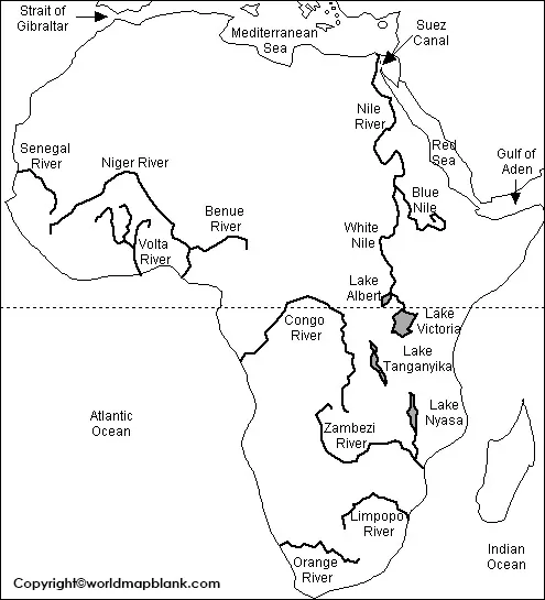
Here is the updated table format for the five longest rivers in Africa as of 2025:
| Rank | River Name | Length (km) | Length (miles) | Key Countries | Notable Features |
|---|---|---|---|---|---|
| 1 | Nile River | 6,650 | 4,132 | Egypt, Sudan, Uganda, Ethiopia, Kenya, DR Congo, Tanzania, Rwanda, Burundi, South Sudan, Eritrea | Longest river in Africa and the world; flows northward into the Mediterranean Sea. |
| 2 | Congo River | 4,700 | 2,920 | DR Congo, Central African Republic, Angola, Republic of Congo, Zambia | Second-longest in Africa; deepest river in the world, with depths over 220 meters. |
| 3 | Niger River | 4,180 | 2,597 | Guinea, Mali, Niger, Benin, Nigeria | Major river of West Africa; empties into the Gulf of Guinea. |
| 4 | Zambezi River | 2,574 | 1,599 | Zambia, Angola, Namibia, Botswana, Zimbabwe, Mozambique | Home to Victoria Falls, one of the largest waterfalls in the world. |
| 5 | Ubangi-Uele Rivers | 2,270 | 1,411 | DR Congo, Central African Republic | Largest tributary of the Congo River; merges from the Uele and Mbomou rivers. |
These rivers play crucial roles in Africa’s ecosystems, economies, and transportation networks.
Africa Map with Countries
An Africa Map with Capitals helps identify the capital city associated with each country.
Capital cities are important geographic reference points because they are generally the centers of national government and administration. However, some countries have special arrangements involving multiple capitals or separate official and administrative centers.
For example, South Africa has three capitals:
- Pretoria – administrative
- Cape Town – legislative
- Bloemfontein – judicial
The South African government officially identifies these three capitals and their respective functions. (Government of South Africa)
Another important recent change is Equatorial Guinea. In January 2026, the country officially transferred its capital from Malabo to Ciudad de la Paz, following a presidential decree dated January 4, 2026. (Ministère des Affaires Étrangères)
This means older Africa maps may still incorrectly show Malabo as the capital of Equatorial Guinea.
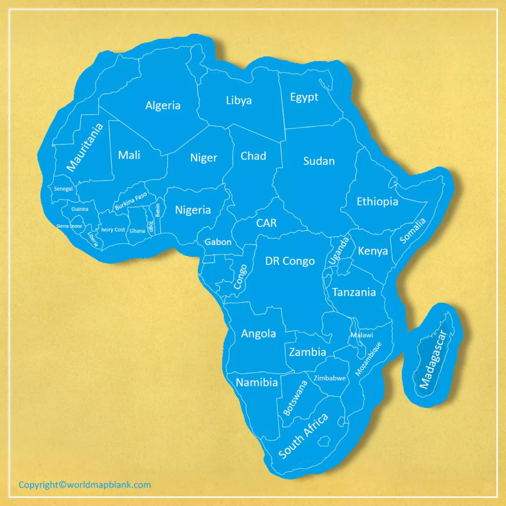
Africa Map with all the Countries
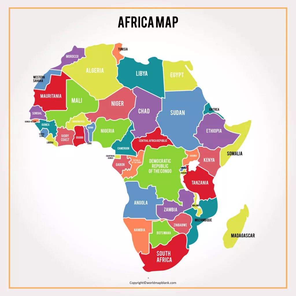
Labeled Africa Map
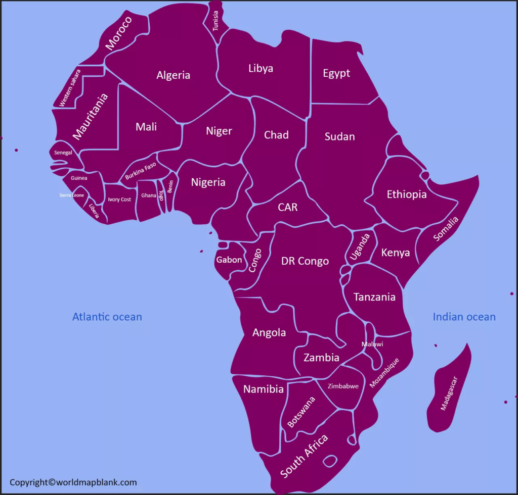
What Is the Largest Country in Africa?
Algeria is the largest country in Africa by total area, covering approximately 2.38 million square kilometers.
Algeria became Africa’s largest country after the independence of South Sudan changed Sudan’s total area.
The Democratic Republic of the Congo is the second-largest country in Africa by area, followed by Sudan.
Africa Population Facts
Africa is the world’s second-largest continent by population after Asia and is currently the fastest-growing continental region in demographic terms.
According to UNData, Africa’s estimated population for 2025 was approximately 1.55 billion people, with a surface area of about 29.65 million square kilometers in the UN regional dataset. (UNdata)
Population figures change every year, so population numbers on an Africa map or country table should always include the year and source.
The United Nations also projects substantial future population growth across Africa, particularly in sub-Saharan Africa. (United Nations)
Most Populous Countries in Africa
The largest populations are concentrated in countries such as:
- Nigeria
- Ethiopia
- Egypt
- Democratic Republic of the Congo
- Tanzania
- South Africa
- Kenya
- Sudan
- Uganda
- Algeria
Exact rankings can change as new population estimates are released. For current population statistics, the UN World Population Prospects should be preferred over undated third-party estimates.
Africa Map With Rivers
An Africa Map with Rivers shows the continent’s major river systems and helps explain its physical geography.
Africa contains several major international river basins that cross national borders. These rivers support agriculture, transportation, hydropower, ecosystems, fisheries, and communities across multiple countries.
The Nile, Congo, Niger, and Zambezi are among the most important major rivers shown on physical maps of Africa.
Major Rivers of Africa
| Rank | River | Approx. Length | Main Region |
|---|---|---|---|
| 1 | Nile | 6,650 km | Northeastern Africa |
| 2 | Congo | 4,700 km | Central Africa |
| 3 | Niger | 4,180 km | West Africa |
| 4 | Zambezi | 2,574 km | Southern/Eastern Africa |
| 5 | Orange | about 2,300 km | Southern Africa |
River lengths can differ between sources because measurements depend on how a river system and its headwaters are defined. The CIA World Factbook lists the Nile at about 6,650 km, the Congo at about 4,700 km and the Niger at about 4,180 km. (CIA)
NASA also gives the Nile an estimated length of approximately 6,695 km and notes that identifying the river’s ultimate source has been a subject of geographic debate. (NASA Science)
Nile River
The Nile River flows northward through northeastern Africa and empties into the Mediterranean Sea.
It is commonly described as the longest river in Africa and is one of the world’s most significant river systems.
Its major tributaries include the White Nile and Blue Nile.
Congo River
The Congo River is one of Africa’s largest rivers by discharge and is the continent’s second-longest major river by many standard measurements.
The Congo Basin covers a huge portion of central Africa and supports the Congo rainforest ecosystem.
Recent scientific research has suggested longer measurements for the Congo system depending on which headwaters are included, demonstrating why river-length figures should be treated as estimates rather than absolute values. (Chinese Academy of Sciences)
Niger River
The Niger River is one of West Africa’s most important rivers. It flows through several countries before reaching the Gulf of Guinea.
Its unusual inland curve through Mali is a notable feature of African physical geography.
Zambezi River
The Zambezi River is one of southern Africa’s major rivers and flows into the Indian Ocean.
The river is particularly well known for Victoria Falls, located on the border between Zambia and Zimbabwe.
Regions of Africa
Africa is commonly divided into five geographic regions:
Northern Africa
Includes countries such as:
- Algeria
- Egypt
- Libya
- Morocco
- Sudan
- Tunisia
Western Africa
Includes:
- Ghana
- Nigeria
- Senegal
- Mali
- Niger
- Guinea
- Côte d’Ivoire
- Liberia
- Sierra Leone
- and other West African states
Central Africa
Includes:
- Cameroon
- Central African Republic
- Chad
- Democratic Republic of the Congo
- Republic of the Congo
- Equatorial Guinea
- Gabon
- São Tomé and Príncipe
Eastern Africa
Includes:
- Ethiopia
- Kenya
- Tanzania
- Uganda
- Rwanda
- Burundi
- Somalia
- South Sudan
- Eritrea
- Djibouti
- Seychelles
- Comoros
- Madagascar
- Mauritius
Southern Africa
Includes:
- South Africa
- Namibia
- Botswana
- Zimbabwe
- Zambia
- Malawi
- Mozambique
- Angola
- Lesotho
- Eswatini
Regional classifications can differ slightly between organizations, so a map should identify the classification system used.
Africa’s Geographic Extremes
Africa has several remarkable geographic features.
Largest Country
Algeria is the largest African country by area.
Smallest Country
Seychelles is the smallest African country by area.
Largest Island Country
Madagascar is Africa’s largest island country.
Largest Desert
The Sahara Desert covers much of northern Africa and is the world’s largest hot desert.
Highest Mountain
Mount Kilimanjaro in Tanzania is Africa’s highest mountain, with its highest summit, Uhuru Peak, at approximately 5,895 meters above sea level.
Longest River
The Nile is generally recognized as Africa’s longest river, although exact river-system measurements vary depending on the source and definition used.
Interesting Facts About Africa
Here are some useful facts that make an Africa map easier to understand:
- Africa is the world’s second-largest continent by land area after Asia.
- The continent contains 54 UN member states.
- The African Union has 55 member states. (African Union)
- Africa’s 2025 population was approximately 1.55 billion according to UNData. (UNdata)
- Algeria is the largest African country by area.
- Seychelles is the smallest African country by area.
- Nigeria is Africa’s most populous country.
- Madagascar is the largest island country in Africa.
- The Nile is one of the world’s major river systems.
- The Congo Basin is one of the world’s most important tropical rainforest regions.
- South Africa has three capital cities serving different government functions. (Government of South Africa)
- Equatorial Guinea officially moved its capital from Malabo to Ciudad de la Paz in January 2026. (Ministère des Affaires Étrangères)
- Africa is surrounded by the Mediterranean Sea, Atlantic Ocean, Indian Ocean, and Red Sea.
Why Use an Africa Map With Countries?
A labeled Africa map can be useful for several purposes.
For Students
Students can use the map to learn:
- Country locations
- Country names
- African capitals
- Neighboring countries
- Regional geography
- Major rivers
- Physical geography
For Teachers
Teachers can use printable Africa maps for:
- Geography worksheets
- Classroom quizzes
- Map-labeling exercises
- Homework
- Country identification activities
- Geography tests
- Classroom displays
For Travel and Research
An Africa map can also help with:
- Understanding regional locations
- Planning travel routes
- Researching countries
- Studying international borders
- Understanding major transportation corridors
- Comparing geographic regions
How to Study African Countries Using a Map
A simple way to learn African geography is to divide the continent into regions.
Step 1: Start with Northern Africa.
Step 2: Learn the countries of Western Africa.
Step 3: Move to Central Africa.
Step 4: Study Eastern Africa and the Horn of Africa.
Step 5: Finish with Southern Africa.
Step 6: Add the capital cities.
Step 7: Test yourself using a blank map.
This method is generally easier than trying to memorize all African countries at once.
Africa Map With Countries – Printable PDF
Our printable Africa Map with Countries is designed to provide a convenient geographic reference.
You can use the map for:
- School projects
- Geography classes
- Educational worksheets
- Country identification
- Presentations
- Home learning
- Research
- General reference
For printing, use the highest-resolution version available and select the appropriate paper size in your printer settings.
If you need a map without country names, use a blank map of Africa for quizzes, assignments, and practice.
Africa Map With Countries vs. Blank Africa Map
A labeled map and blank map serve different purposes.
| Map Type | Best For |
|---|---|
| Labeled Africa Map | Learning country locations |
| Africa Map With Capitals | Learning capitals |
| Blank Africa Map | Testing geographic knowledge |
| Africa Map With Rivers | Physical geography |
| Africa Political Map | Country boundaries |
| Africa Physical Map | Mountains, rivers and terrain |
Using several map types together can make geography learning more effective.
Frequently Asked Questions
How many countries are in Africa?
There are 54 UN member states in Africa. The African Union has 55 member states, including the Sahrawi Arab Democratic Republic. (Ask UN)
What is the largest country in Africa?
Algeria is the largest country in Africa by area, covering approximately 2.38 million square kilometers.
What is the smallest country in Africa?
Seychelles is the smallest country in Africa by land area.
What is the most populous country in Africa?
Nigeria is the most populous country in Africa. Population rankings should be checked against the latest UN population estimates because they change over time.
What is the capital of Africa?
Africa does not have a single capital because it is a continent, not a country.
The African Union’s headquarters are in Addis Ababa, Ethiopia, which is an important political and diplomatic center for the continent.
What is the longest river in Africa?
The Nile River is generally recognized as the longest river in Africa. Commonly cited measurements are around 6,650–6,695 km, although exact figures vary according to how the river system is measured. (CIA)
How many countries are shown on an Africa map?
A standard political Africa map generally shows the 54 UN member states. Some maps also depict Western Sahara separately because of its disputed political status.
Which country has three capitals in Africa?
South Africa has three capitals: Pretoria, Cape Town, and Bloemfontein. They serve administrative, legislative, and judicial functions respectively. (Government of South Africa)
What is the new capital of Equatorial Guinea?
Since January 2026, Ciudad de la Paz is the official capital of Equatorial Guinea. The capital was previously Malabo. (Ministère des Affaires Étrangères)
Is Western Sahara a country?
Western Sahara has a disputed political status. The African Union includes the Sahrawi Arab Democratic Republic among its 55 member states, while the United Nations does not count it among the 54 African UN member states. (Ask UN)
What are the five regions of Africa?
Africa is commonly divided into Northern Africa, Western Africa, Central Africa, Eastern Africa, and Southern Africa.
Sources and References
For geographic and statistical accuracy, the following authoritative sources are recommended:
- United Nations – African regional group: confirms the 54 African UN member states. (United Nations)
- African Union – About the AU: confirms the AU’s 55 member states. (African Union)
- UNData – Africa: provides regional population and surface-area statistics. (UNdata)
- United Nations Population: provides information on Africa’s demographic growth and population projections. (United Nations)
- South African Government: official information on South Africa’s three capitals. (Government of South Africa)
- Government of Equatorial Guinea: official information regarding the 2026 capital transfer to Ciudad de la Paz. (Ministère des Affaires Étrangères)
- CIA World Factbook: reference data for major river lengths. (CIA)
- NASA Earth Observatory: Nile River geographic information. (NASA Science)
Editorial and Data Note
Geographic boundaries, capital cities, population estimates, and political classifications can change. This page should therefore be reviewed periodically and updated when authoritative sources publish new information.
Population figures should always be presented with the year and source, while disputed territories should be clearly identified rather than presented as universally recognized sovereign states.
This approach helps keep the Africa Map with Countries resource useful for students, teachers, researchers, and general readers while reducing the risk of outdated geographic information.
Reference links to add as outbound links
I recommend adding these as normal follow outbound links rather than nofollow:
- United Nations – African States
- United Nations – 54 African UN Member States
- African Union – About the African Union
- UNData – Africa Statistics
- United Nations – Population Information
- South African Government – Capitals of South Africa
- CIA World Factbook – Major Rivers
- NASA – Quest for the Source of the Nile

6 thoughts on “Africa Map with Countries – Labeled Map of Africa [PDF]”