


Explore the Printable Africa Rivers Map to locate major rivers, understand Africa’s drainage systems, and learn important physical geography facts. This page provides free river map images and PDF downloads, including a labeled map for students, teachers, researchers, and geography enthusiasts.
Use these printable maps for school assignments, classroom activities, revision, or personal learning. Choose the map version that best suits your needs and download the PDF for convenient printing.
Africa Rivers Map
Africa has a diverse network of rivers shaped by its climate, highlands, plateaus, tropical forests, and deserts. These waterways support communities, agriculture, transportation, fisheries, and hydroelectric power across the continent.
The Nile, Congo, Niger, Zambezi, Orange, Senegal, and Volta are among Africa’s major rivers. Their drainage basins vary considerably in size, climate, and the countries they cross.
Download the Africa Rivers Map to identify the main river systems and understand how they are distributed across the continent.

Map of Africa Rivers
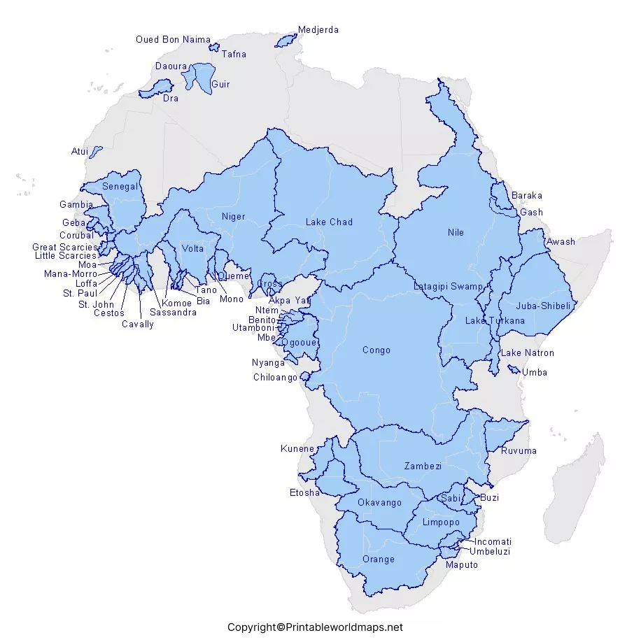
A map of Africa’s rivers highlights the locations, courses, and distribution of the continent’s major waterways. Depending on the map, it may show river names, tributaries, lakes, surrounding countries, and river outlets.
River maps are useful for understanding where water flows, which regions depend on particular river systems, and how rivers connect inland areas with the Atlantic Ocean, Indian Ocean, Mediterranean Sea, or inland lakes.
For the best results, compare the river map with a political map of Africa. This makes it easier to identify the countries through which a river flows.

Map of Africa Rivers Labeled
The Africa rivers map labeled version is particularly useful for geography lessons, classroom exercises, and self-study. River names help readers connect the waterways shown on the map with their locations and surrounding geographical features.
When studying a labeled map, try locating each river before checking its name. You can also trace its general direction of flow and identify the ocean, sea, lake, or river into which it drains.
Students should check the labels and geographic details on the map before using it for formal assignments, especially when precise tributaries or smaller rivers are required.

Printable Africa Rivers Map
A printable Africa rivers map provides a convenient way to study African river systems without relying entirely on a screen. Print the map for classroom discussions, homework, revision, geography projects, or personal reference.
Choose the PDF version for printing or saving, and use the image version for quick viewing. For detailed labels, select a suitable print size and check the preview before printing.
How to use the printable map:
- Open the river map image or PDF using the links above.
- Review the river names and their locations.
- Print the map at a size that keeps labels readable.
- Trace selected rivers and identify the countries and water bodies associated with them.
- Use an atlas or a trusted geographical reference to verify additional details.
7 Major Rivers in Africa and Their Facts
Learning the names and characteristics of major rivers makes an Africa rivers map more useful. The following examples introduce seven important African river systems.
1. Nile River
The Nile flows northward through northeastern Africa and empties into the Mediterranean Sea. Its river system is closely associated with the White Nile, Blue Nile, and other tributaries. The Nile has played an important role in agriculture, settlement, and the history of Egypt and neighboring regions.
2. Congo River
The Congo River flows through Central Africa and reaches the Atlantic Ocean. Its extensive basin includes large areas of tropical rainforest. The river is notable for its immense discharge and exceptional depth, and it supports transportation, fisheries, and ecosystems throughout the basin.
3. Niger River
The Niger is a major river of West Africa. It follows a distinctive curved course through several landscapes, including the inland delta in Mali, before reaching the Gulf of Guinea in Nigeria. The river supports farming, fishing, and communities across its basin.
4. Zambezi River
The Zambezi flows eastward across southern Africa and enters the Indian Ocean in Mozambique. It is associated with Victoria Falls and major hydroelectric facilities. The Zambezi River Basin extends across several countries, making cooperation over water resources important.
5. Orange River
The Orange River, also known as the Gariep in some local contexts, is a major river of southern Africa. It flows westward from the Lesotho highlands across South Africa toward the Atlantic Ocean. Its water is important for irrigation and other uses in an otherwise relatively dry region.
6. Senegal River
The Senegal River forms part of the geographical boundary between Senegal and Mauritania along sections of its course. It drains parts of West Africa and flows into the Atlantic Ocean. The river is important for irrigation, local livelihoods, and regional water management.
7. Volta River
The Volta River system is located in West Africa and is closely associated with Ghana. The Black Volta, White Volta, and Oti are important components of the wider system. Lake Volta, formed by the Akosombo Dam, is a major feature of Ghana’s water and energy geography.
Why Are African Rivers Important?
African rivers have physical, economic, and ecological importance. Their value differs from one region to another, depending on rainfall, terrain, population, infrastructure, and water availability.
- Agriculture: Rivers provide water for irrigation and help sustain farming communities.
- Hydroelectricity: Dams on river systems such as the Nile and Zambezi support electricity generation.
- Transportation: Some rivers act as transport routes where navigable conditions permit.
- Biodiversity: River channels, wetlands, floodplains, and deltas provide habitats for many species.
- Livelihoods: Fishing, tourism, and other river-related activities support local economies.
- Regional cooperation: Many river basins cross national borders, making water management a shared responsibility.
How to Read an Africa Rivers Map
To get the most value from your map, start by locating the continent’s major regions: North Africa, West Africa, Central Africa, East Africa, and Southern Africa. Then identify the largest rivers and follow their courses toward their outlets.
Look for tributaries, lakes, deltas, and inland drainage areas. Remember that not every river flows directly into the ocean; some waterways drain into lakes, wetlands, or inland basins.
Map scale and label detail also matter. A general continent-wide map is excellent for an overview, while a regional map or detailed atlas may be more appropriate for smaller rivers and tributaries.
Frequently Asked Questions
Where can I download a printable Africa rivers map?
You can download the Africa rivers map from the image and PDF links provided in this article. A labeled version is also available for geography study and classroom activities.
Which are the major rivers of Africa?
Major African rivers include the Nile, Congo, Niger, Zambezi, Orange, Senegal, and Volta. Other important waterways include the Limpopo, Gambia, and Ogooué.
Which direction does the Nile River flow?
The Nile generally flows northward through northeastern Africa before reaching the Mediterranean Sea.
Which African river flows into the Atlantic Ocean?
Several major rivers reach the Atlantic Ocean, including the Congo, Niger, Orange, Senegal, and Gambia. Their locations and drainage patterns differ across the continent.
Why is the Congo River important?
The Congo River supports ecosystems, communities, transportation, fisheries, and economic activity in Central Africa. Its basin includes extensive tropical rainforest.
Can I use the Africa rivers map for school projects?
Yes. The printable maps can be useful for school projects, revision, and geography activities. Check the map’s labels and confirm important facts with a reliable reference before submitting academic work.
What is the difference between a river and a river basin?
A river is a natural flowing body of water. A river basin is the area of land from which rainfall and other surface water drain into that river and its tributaries.
Are the Africa rivers map downloads free?
The image and PDF links are provided here for readers to access. Check the website’s applicable terms and any copyright notices before redistributing or republishing the maps.
Reference links
https://education.nationalgeographic.org/resource/nile-river
https://education.nationalgeographic.org/resource/africa-physical-geography
https://education.nationalgeographic.org/resource/understanding-rivers
Nile Basin Initiative:
https://nilebasin.org/nile-basin
https://nilebasin.org/en/media-center/maps/major-subbasins
Food and Agriculture Organization (FAO):
https://www.fao.org/4/W4347E/w4347e0n.htm
https://www.fao.org/4/w4347e/w4347e0o.htm
U.S. Geological Survey:
https://www.usgs.gov/centers/eros/science/physical-geography
More Free Maps for Download
Here are some useful links to other printable world maps, continent maps and country maps for download as PDF files.
World Maps
- Labeled World Map
- Time Zone World Map
- World Map with Continents
- Physical World Map
- Political World Map
Continent Maps
- Africa Map with Countries
- Labeled Map of South America
- Blank Map of Asia
- Labeled Map of Europe
- Physical Map of Australia
- Blank Map of South America
