

A labeled map of Andorra helps you identify the country’s capital, major towns, administrative parishes, rivers, and mountainous landscape. Andorra is a small, landlocked country in southwestern Europe, situated in the eastern Pyrenees between Spain and France. It covers approximately 468 square kilometres and is known for its mountain scenery, ski resorts, and historic villages.
This collection includes printable maps of Andorra with its seven parishes, capital, and major cities and towns. You can use the maps for geography lessons, school assignments, travel planning, presentations, and general reference.
- World map with continents
- Physical world map
- Political world map
- Labeled map of Asia
- Labeled map of Africa
- Labeled map of Europe
- Labeled map of South America
- World time zone map
- Labeled map of World
- Blank map of world
- Labeled map of North America
- Blank map of Asia
- World map with oceans
- World map poster
Labeled Map of Andorra
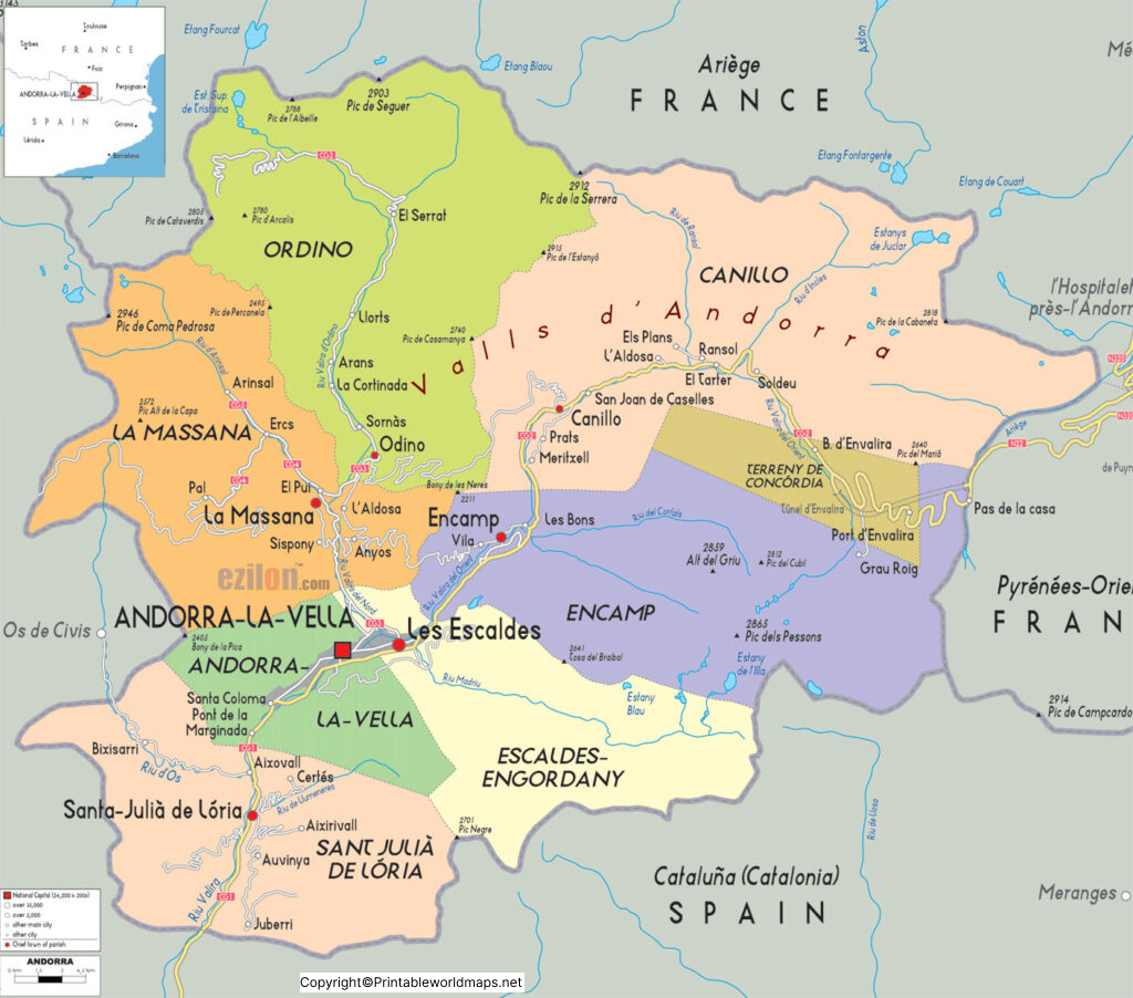
A labeled map of Andorra provides a geographical overview of the country and helps readers understand the locations of its settlements and natural features.
Andorra’s landscape consists mainly of high mountains, narrow valleys, forests, and rivers. The Gran Valira is the country’s principal river system, formed by the meeting of the Valira del Nord and Valira d’Orient. These river valleys have played an important role in the location and development of Andorra’s towns.
Key facts about Andorra
- Official name: Principality of Andorra
- Capital: Andorra la Vella
- Location: Eastern Pyrenees, between Spain and France
- Total area: Approximately 468 km²
- Administrative divisions: Seven parishes
- Official language: Catalan
- Currency: Euro (€)
- Highest point: Comapedrosa, approximately 2,942 metres
- Geographical features: Mountains, forests, valleys, rivers, and glacial lakes
For official geographical and travel information, consult Visit Andorra.
Labeled Map of Andorra with States
Andorra is divided into seven administrative areas called parishes, rather than states or provinces. These parishes form the country’s principal local administrative divisions.
The seven parishes are:
- Canillo
- Encamp
- Ordino
- La Massana
- Andorra la Vella
- Sant Julià de Lòria
- Escaldes-Engordany
A labeled map of Andorra with parishes helps students and readers identify these administrative areas and understand how the country’s territory is organised. Although the term “states” is sometimes used in map searches, “parishes” is the correct administrative term for Andorra.
Labeled Map of Andorra with Cities
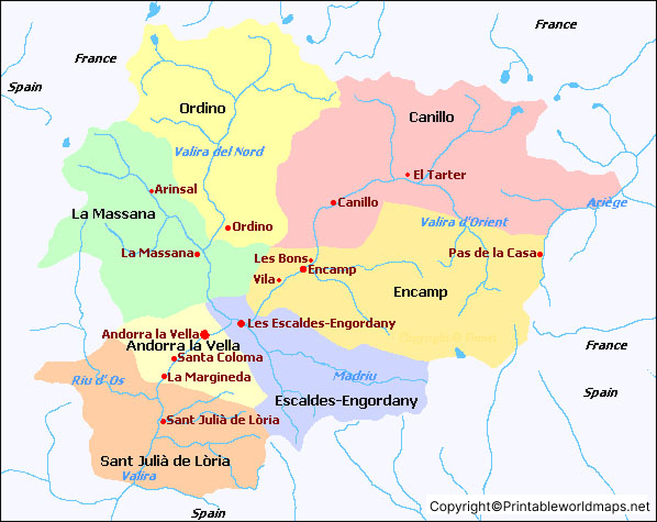
A labeled map of Andorra with cities helps readers locate important towns and settlements throughout the country. Andorra has numerous villages and urban areas, many of which developed along river valleys and mountain roads.
Important towns and settlements include:
- Andorra la Vella: The national capital and a major commercial centre.
- Escaldes-Engordany: An urban parish adjoining the capital, known for its thermal waters and Caldea spa complex.
- Encamp: A town with access to mountain recreation and the Grandvalira ski area.
- Sant Julià de Lòria: A southern parish near the Spanish border.
- La Massana: A mountain parish associated with the Pal-Arinsal ski area.
- Ordino: Known for its traditional architecture and mountain scenery.
- Canillo: A mountainous parish with access to ski slopes and hiking areas.
- Santa Coloma: A settlement near Andorra la Vella, known for its historic church.
- El Pas de la Casa: A mountain settlement close to the French border and a well-known ski destination.
- Arinsal: A village in La Massana that provides access to mountain trails and the Comapedrosa area.
These places differ in size and administrative status. Some are towns or villages within the seven parishes, so they should not all be described as separate administrative divisions.
Labeled Andorra with Capital
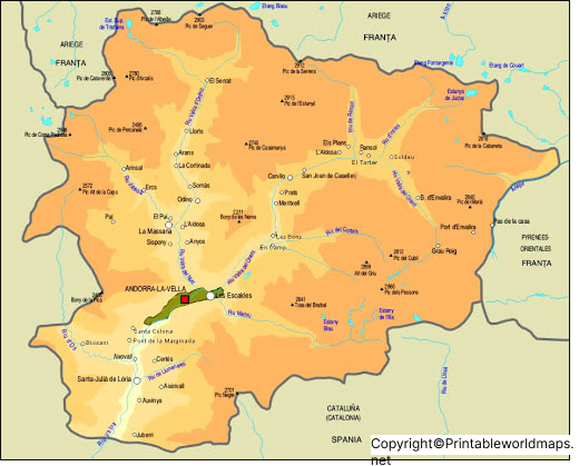
Andorra la Vella is the capital of the Principality of Andorra. Located in the central part of the country, it is an important centre for government, commerce, shopping, and tourism.
The capital lies in a mountainous setting near the Gran Valira river system. Its urban area connects with neighbouring settlements, including Escaldes-Engordany, making this part of Andorra an important population and commercial centre.
Catalan is the country’s official language. Spanish, French, and Portuguese are also used in everyday life because of Andorra’s geographical position and international population.
Andorra’s economy includes tourism, retail trade, financial services, and other service industries. The country’s mountain environment attracts visitors throughout the year, with skiing and winter sports particularly important during the colder months.
Geography and Landscape of Andorra
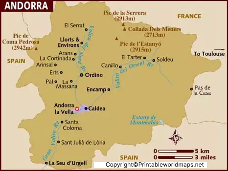
Andorra is a mountainous country in the eastern Pyrenees. Its terrain includes steep slopes, high peaks, forested hillsides, narrow valleys, and mountain lakes. The settlements are concentrated largely in the valleys, where transport routes and rivers connect communities.
Comapedrosa, at approximately 2,942 metres, is Andorra’s highest peak. The Gran Valira and its tributaries are important geographical features, while lakes such as Juclà and the Tristaina lakes add to the country’s distinctive mountain landscape.
Because of its elevation, Andorra experiences cold winters with regular snowfall at higher altitudes. Summers are generally milder in the mountains than in many surrounding lowland areas.
A physical map is useful for studying elevation and natural features, while a labeled political or administrative map is more suitable for identifying parishes, towns, and the capital.
Population and Area of Andorra
Andorra covers approximately 468 square kilometres, making it one of Europe’s smallest countries. Its population figures vary by year and statistical source, so older estimates should not be presented as current data.
The official tourism authority reports a population of 85,101 based on the 2023 census. For newer population figures, consult the Andorran government’s Department of Statistics rather than relying on historical estimates.
The country’s compact size does not mean its geography is uniform. Mountain ranges, valleys, and differences in elevation influence settlement patterns, road connections, tourism, and land use.
How to Use and Print the Andorra Maps
These maps can be used for educational activities, geography revision, travel research, and presentations.
- Choose a map: Select the map showing the capital, towns, or administrative parishes you need.
- Open the image: Use the PNG link to view the map in your browser.
- Download the PDF: Choose the PDF version when you need a document for printing.
- Check the labels: Make sure the place names are readable at your chosen print size.
- Use the map appropriately: For schoolwork, identify the source and distinguish administrative parishes from towns and villages.
For the clearest results, select a print size that preserves the legibility of small place names. The downloadable file’s resolution and page layout will determine the best print size.
Frequently Asked Questions About Andorra Maps
1. What is the capital of Andorra?
Andorra la Vella is the capital of Andorra. It is an important centre for government, shopping, business, and tourism.
2. How many states are there in Andorra?
Andorra does not have states. It has seven administrative divisions called parishes: Canillo, Encamp, Ordino, La Massana, Andorra la Vella, Sant Julià de Lòria, and Escaldes-Engordany.
3. What is the official language of Andorra?
Catalan is the official language of Andorra. Spanish, French, and Portuguese are also widely used.
4. What countries border Andorra?
Andorra is bordered by Spain to the south and France to the north. It is a landlocked country in the eastern Pyrenees.
5. What is the highest mountain in Andorra?
Comapedrosa is the highest mountain in Andorra, with an elevation of approximately 2,942 metres.
6. Can I download a labeled map of Andorra as a PDF?
Yes. PDF versions of the maps are linked above. Open the relevant PDF link to view or download the file for printing and educational use.
7. What is the difference between a map of Andorra with cities and a map with parishes?
A city map identifies settlements and towns, while a parish map shows Andorra’s seven main administrative divisions. The two types of maps serve different geographical purposes.
8. What is the best map of Andorra for school projects?
A labeled map showing the capital, towns, and seven parishes is useful for general geography projects. A physical map is more appropriate when the assignment focuses on mountains, rivers, valleys, and elevation.
Conclusion
A labeled map of Andorra is a useful resource for understanding the country’s capital, settlements, administrative parishes, and mountainous geography. The downloadable PNG and PDF maps can support school assignments, geography lessons, travel research, and general reference. For the most reliable information about Andorra’s population, administrative divisions, and geographical features, compare map labels with official government and tourism sources.
Reference links
https://visitandorra.com/en/essential-information-about-andorra/
