


A labeled map of the world makes it easier to identify countries, continents, oceans, and seas at a glance. On this page, you can download free printable world maps in PDF format for geography lessons, classroom activities, homework, and personal study.
Choose a map with country names or a map that labels the seven continents and oceans. You can view the maps online, download the PDF files, and print them for convenient reference.
If you need a different style, explore our related blank world maps, political maps, maps showing oceans and seas, and world maps for kids. Teachers and parents can also use printable map worksheets to help learners practise geography.
Labeled Map of the World
Our first labeled map of the world shows country names, along with oceans and seas. This political world map is useful for identifying countries and understanding their relative locations across the globe.
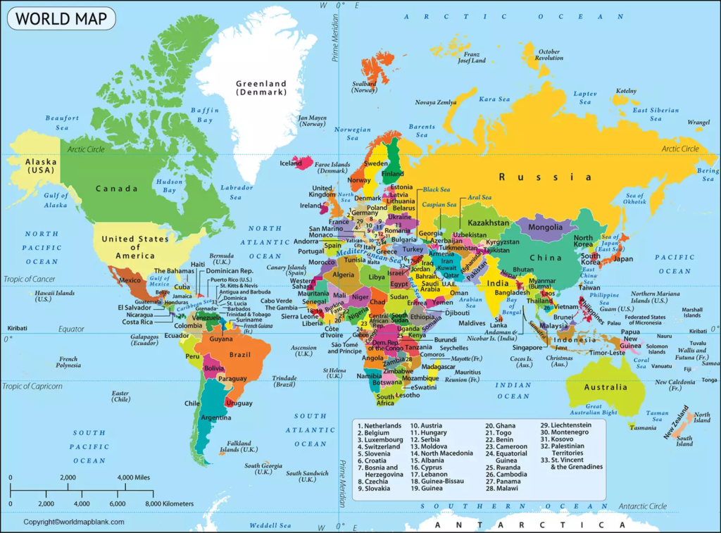
Use this map for school assignments, geography revision, country identification exercises, and general reference. For the clearest printed result, select a paper size that keeps the country labels readable.
Map of the World Labeled With Continents and Oceans
This labeled world map focuses on the seven continents and the world’s oceans. It is a useful option for students who are learning the basic structure of Earth’s landmasses and major bodies of water.
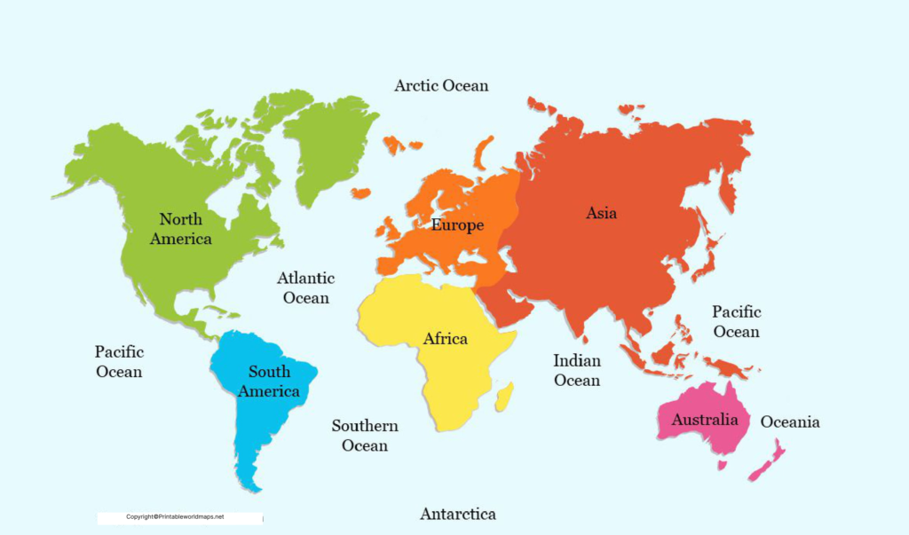
The seven continents are Africa, Antarctica, Asia, Europe, North America, South America, and Australia. Some educational systems use the term Oceania for the broader region that includes Australia and many Pacific islands.
This map is suitable for introductory geography lessons, classroom displays, and activities that ask learners to locate continents and oceans.
For more detailed regional study, explore our maps of Africa, North America, South America, Europe, Asia, Australia, and Antarctica.
Labeled World Map With Countries
A world map with countries labeled helps readers locate national boundaries and learn country names. It can also be useful when studying international geography, world regions, and the locations of neighboring countries.
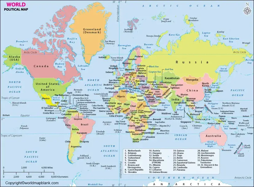
Before using a map for a formal report or current-events assignment, check its publication date and boundary conventions. Political boundaries, place names, and the international status of certain territories can change or be represented differently by different publishers.
How Many Countries Are There in the World?
A commonly used count is 195 countries: the 193 United Nations member states plus the two UN General Assembly non-member observer states, the Holy See and the State of Palestine.
However, the number depends on the definition of a country and the recognition criteria being used. Some territories and states have disputed or limited international recognition, so not every source uses the same total.
For authoritative background, consult the United Nations’ official pages on member states and non-member observer states:
A labeled world map is a useful starting point for identifying countries, but a map’s labels and boundaries should be read in the context of its source and publication date.
What Are the Largest Countries in the World?
Countries can be ranked by land area, total surface area, or population. These measures are different, so it is important to specify which one a list uses.
10 Largest Countries in the World by Land Area
The following figures are rounded land-area estimates in square kilometres, based on the World Bank’s land-area data for 2024. They exclude inland water area as defined by that indicator.
| Rank | Country | Land area (approx.) |
|---|---|---|
| 1 | Russia | 16.38 million km² |
| 2 | China | 9.39 million km² |
| 3 | United States | 9.15 million km² |
| 4 | Canada | 8.79 million km² |
| 5 | Brazil | 8.36 million km² |
| 6 | Australia | 7.69 million km² |
| 7 | India | 2.97 million km² |
| 8 | Argentina | 2.74 million km² |
| 9 | Kazakhstan | 2.70 million km² |
| 10 | Algeria | 2.38 million km² |
Note that rankings can differ when total surface area is used instead of land area. This is particularly relevant when comparing countries with substantial inland water areas.
10 Largest Countries in the World by Population
Population estimates change over time because of births, deaths, and migration. For a reliable comparison, use estimates from the same year and the same statistical source.
The United Nations’ World Population Prospects 2024 provides population estimates and projections by country. Its estimates identify India and China as the two most populous countries, followed by the United States, Indonesia, and Pakistan.
For an up-to-date, consistent ranking, consult the UN’s population data rather than combining figures from different years:
When using population figures in a school project or article, state the reference year. Projections are estimates of possible future population levels, not guaranteed outcomes.
Seven Interesting Facts About the World Map
- Earth has seven commonly recognized continents. The seven-continent model is widely used in schools, although continent classifications vary between educational traditions.
- The Pacific Ocean is the largest ocean. It stretches across a vast area between Asia and Australia on one side and the Americas on the other.
- Antarctica surrounds the geographic South Pole. It is the southernmost continent and is covered largely by ice.
- Russia spans Europe and Asia. Its enormous territory makes it the world’s largest country by land area.
- Africa is crossed by the Equator. The Equator also passes through parts of South America and Asia, as well as several island regions.
- A flat world map always involves distortion. Because Earth is approximately spherical, projecting its surface onto a flat sheet changes some combination of area, shape, distance, or direction.
- Political maps and physical maps serve different purposes. Political maps emphasize borders and place names, while physical maps highlight natural features such as mountains, rivers, and plains.
These facts can help students use a labeled world map for more than memorizing country names. They also provide a starting point for exploring climate, landforms, oceans, and the relationships between geographical regions.
How to Print a Labeled Map of the World
Follow these steps to print your chosen map:
- Select the map that best matches your learning or reference needs.
- Open the PDF download link.
- Save the file to your device.
- Open the PDF in a viewer and select Print.
- Choose landscape or portrait orientation according to the map’s proportions.
- Use print preview to check that labels and borders are visible and not cut off.
- Select a suitable paper size and print quality before printing.
For maps with many country names, larger paper such as A3 can improve readability if your printer supports it. If you are printing on A4 paper, use the fit-to-page option and check the preview before printing.
For classroom worksheets, consider printing one copy for reference and additional copies for students to annotate or use in geography quizzes.
How to Use a Labeled World Map for Learning
A labeled world map can support several simple geography activities:
- Country identification: Ask learners to find countries by name and locate their neighboring countries.
- Continents and oceans: Practise naming all seven continents and the five commonly recognized oceans.
- Regional comparisons: Compare countries by location, climate zone, land area, or population using reliable reference sources.
- Map-label practice: Pair a labeled map with a blank map to test recall.
- Classroom projects: Mark selected countries, capitals, major mountain ranges, or important rivers using a consistent legend.
For younger learners, start with continents and oceans before introducing individual countries. Older students can use political and physical maps together to explore how geography relates to population, transport, climate, and trade.
Frequently Asked Questions About Labeled World Maps
1. Where can I download a labeled map of the world for free?
You can use the PDF links provided in this article to download maps showing country names, continents, and oceans. Check each file before printing to confirm that it matches your needs.
2. What does a labeled world map show?
A labeled world map may show country names, national borders, continents, oceans, seas, and sometimes capitals or other geographical features. The exact information depends on the map design.
3. Can I print a labeled world map in PDF format?
Yes. Open the PDF, save it to your device, and print it using a suitable paper size and orientation. Check the print preview to make sure labels are readable.
4. How many continents are there in the world?
The commonly taught seven-continent model includes Africa, Antarctica, Asia, Europe, North America, South America, and Australia. Some systems classify continents differently.
5. How many countries are there in the world?
A common total is 195: 193 UN member states and two non-member observer states. Other totals may be used depending on how countryhood and international recognition are defined.
6. What is the difference between a political map and a physical map?
A political map highlights country borders, administrative boundaries, and place names. A physical map emphasizes natural features such as elevation, mountains, rivers, and plains.
7. Which world map is best for students?
A map with clear country labels is useful for learning national names and locations. A continents-and-oceans map is often easier for beginners, while a blank map is useful for practice and testing.
8. Why do some world maps look different from others?
Maps can use different projections, scales, label conventions, boundary representations, and publication dates. A flat map also distorts some aspects of Earth’s curved surface, so shapes and areas may appear different depending on the projection.
Reference links
https://www.un.org/en/about-us/member-states
https://www.un.org/en/about-us/non-member-states
https://data.worldbank.org/indicator/AG.LND.TOTL.K2
https://digitallibrary.un.org/record/4018339/files/GEGN.2_2023_116_CRP.116-FR.pdf
https://en.wikipedia.org/wiki/PDF
More Maps of the World, Continents, and Countries
Please find below a list of other useful maps of the world, its continents, and countries. Check them out and get your free printable maps as PDF files.
Continent Maps
- Political Map of Europe
- Blank Map of Europe
- Physical Map of Europe
- Labeled Map of Europe
- Blank Map of Asia
- Labeled Map of Asia
- Labeled Map of Africa
- Africa Political Map
- North America Political Map
- Political Map of South America
- Blank Map of South America
- Labeled Map of Australia

16 thoughts on “Labeled Map of the World – Map of the World Labeled [PDF]”