
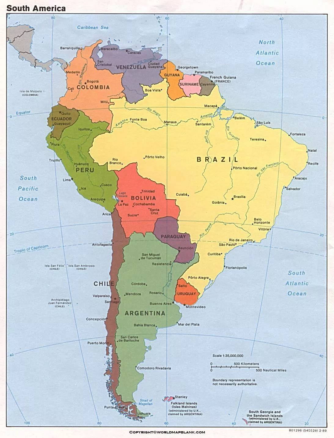

Our South America Political Map helps students, teachers, travelers, and geography enthusiasts explore the continent’s national boundaries and political divisions. View the labeled map online or download a printable PDF for classroom activities, geography assignments, and personal study.
South America has 12 sovereign countries. A political map helps readers identify these countries, compare their locations, and understand their neighboring borders. French Guiana is also shown on many regional maps, but it is an overseas department of France rather than an independent country.
South America Political Map
South America is located entirely in the Western Hemisphere, with most of the continent in the Southern Hemisphere. It is the world’s fourth-largest continent by land area and is bordered by the Pacific Ocean to the west and the Atlantic Ocean to the east. The Caribbean Sea lies to the north.

The map displays the countries and their political boundaries, helping readers understand how the continent is divided. Depending on the map version, additional details may include country names, neighboring territories, coastlines, and internal administrative boundaries.
Map of South America Political
A political map focuses on national borders, country names, and other administrative divisions rather than primarily showing mountains, rivers, or elevation. It is useful for learning where each country is located and which nations share a border.
South America’s 12 sovereign countries are Argentina, Bolivia, Brazil, Chile, Colombia, Ecuador, Guyana, Paraguay, Peru, Suriname, Uruguay, and Venezuela.

South American countries have different political systems and administrative structures. A political map provides a geographical overview of their locations and boundaries; it does not necessarily explain current political events, disputed borders, or changes in government.
Map of South America Political Labeled
A labeled South America political map makes it easier to identify individual countries without repeatedly consulting a separate reference. It is particularly useful for school assignments, geography quizzes, classroom displays, and map-labeling exercises.

When studying the labeled map, start with Brazil, the continent’s largest country by area. Then locate Argentina in the south, Chile along the western edge, and Peru and Ecuador on the Pacific side. Continue by identifying Colombia and Venezuela in the north, followed by Bolivia, Paraguay, Uruguay, Guyana, and Suriname.
Check the labels carefully when using a map for educational or research purposes. Not every political map includes state, province, or department boundaries, and some maps may use different conventions for territories.
Printable South America Political Map
A printable South America political map is convenient for offline learning, homework, revision, and classroom activities. Choose the PNG image for quick viewing or printing, or use the PDF version when you want a document that is easier to save and print.

For the clearest print, select a suitable paper size, use the print preview to check the orientation, and choose a high-quality print setting. If country names appear too small, print on a larger sheet or zoom in on the digital version before printing.
Before using a map in a report, presentation, or publication, check its date, source, labeling, and terms of use. Political boundaries and territorial descriptions can change, so use an authoritative reference when current or official information is required.
Countries of South America and Their Capitals
South America has 12 sovereign countries. The following table lists each country and its commonly recognized capital city. Bolivia has Sucre as its constitutional capital, while La Paz is the seat of government.
| Country | Capital |
|---|---|
| Argentina | Buenos Aires |
| Bolivia | Sucre; La Paz is the seat of government |
| Brazil | Brasília |
| Chile | Santiago |
| Colombia | Bogotá |
| Ecuador | Quito |
| Guyana | Georgetown |
| Paraguay | Asunción |
| Peru | Lima |
| Suriname | Paramaribo |
| Uruguay | Montevideo |
| Venezuela | Caracas |
Use this list alongside the political map to practice matching country names with their locations and capitals.
Important Facts About South America
- 12 sovereign countries: The continent contains 12 independent countries.
- Largest country: Brazil is the largest South American country by area.
- Smallest sovereign country by area: Suriname is the smallest of the 12 sovereign countries by area.
- Major mountain range: The Andes extend along much of the continent’s western side.
- Major river system: The Amazon River and its tributaries form one of the world’s largest river systems.
- Language diversity: Spanish and Portuguese are widely spoken, while English, Dutch, French, Indigenous languages, and other languages are also used across the continent.
- French Guiana: This territory is geographically part of South America but politically an overseas department of France, not a thirteenth sovereign country.
These facts provide additional context for interpreting the political map and understanding the continent’s geography.
How to Use a South America Political Map
- Identify all 12 sovereign countries using their labels.
- Locate each country’s capital with a separate capitals reference if the map does not show capital cities.
- Compare neighboring countries and trace their shared land borders.
- Find the Atlantic and Pacific coasts to understand the continent’s position.
- Use a blank map to test your knowledge by labeling countries from memory.
- Consult an authoritative source if you need current administrative boundaries or information about disputed territories.
Frequently Asked Questions
How many countries are there in South America?
How many countries are there in South America?
What does a South America political map show?
A political map shows countries, national boundaries, and country names. Some versions also show capital cities and internal administrative divisions.
Can I download a South America political map in PDF format?
Yes. The PDF links provided above let you access printable versions of the South America political map. Check the downloaded file before printing to confirm that it has the labels and layout you need.
Which is the largest country in South America?
Brazil is the largest country in South America by area and occupies a substantial part of the continent.
Is French Guiana a country in South America?
No. French Guiana is geographically located in South America but is an overseas department and region of France. It is not an independent sovereign country.
What is the capital of Bolivia?
Sucre is Bolivia’s constitutional capital, while La Paz is the seat of government. Both names are useful to know when studying South American capitals.
What is the difference between a political map and a physical map?
A political map emphasizes countries, boundaries, and administrative divisions. A physical map emphasizes natural features such as mountains, rivers, plains, and elevation.
Who can use a printable South America political map?
Students, teachers, researchers, travelers, and geography enthusiasts can use it for learning, assignments, revision, presentations, and general reference.
Reference links
https://education.nationalgeographic.org/resource/Continent
https://www.un.org/geospatial/mapsgeo/generalmaps
https://www.cia.gov/the-world-factbook/static/9f46f4dbc5f42b191f5a8cda6c46cd36/south_america_phy.pdf

2 thoughts on “South America Political Map – Map of South America Political”