

The map of Mediterranean world helps visualize the Mediterranean Sea, the countries surrounding it, and the geographic regions connecting southern Europe, North Africa, and western Asia. The Mediterranean Sea is an important semi-enclosed sea of the Atlantic Ocean, connected to the Atlantic through the Strait of Gibraltar.
Map of Mediterranean World

The Mediterranean region is much larger than a group of seven countries. The Mediterranean Sea is bordered by countries in Europe, Africa, and Asia, including Spain, France, Monaco, Italy, Slovenia, Croatia, Bosnia and Herzegovina, Montenegro, Albania, Greece, Turkey, Cyprus, Syria, Lebanon, Israel, Palestine, Egypt, Libya, Tunisia, Algeria, and Morocco.
The exact list can vary depending on whether a source is referring specifically to countries with a coastline on the Mediterranean Sea or to the broader Mediterranean region.
The Mediterranean Sea covers approximately 2.5 million square kilometers and extends from the Atlantic Ocean in the west toward the Levant in the east. Its geography includes numerous islands, peninsulas, gulfs, straits, and smaller seas.

Mediterranean Sea on World Map
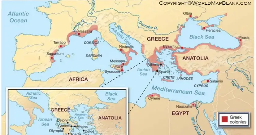
On a world map, the Mediterranean Sea is located between southern Europe, northern Africa, and western Asia. It provides an important geographic connection between these three continents.
The Mediterranean is connected to the Atlantic Ocean through the Strait of Gibraltar. It also connects with the Red Sea through the Suez Canal, which provides an important maritime route between the Mediterranean and the Indian Ocean.
Important geographical subdivisions include the:
- Aegean Sea
- Adriatic Sea
- Ionian Sea
- Tyrrhenian Sea
- Ligurian Sea
- Balearic Sea
- Alboran Sea
- Levantine Sea
These smaller seas help explain the complex geography shown on a detailed Mediterranean Sea map.
Printable Map of Mediterranean World
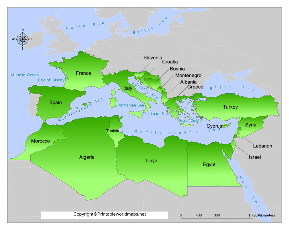
A printable map of Mediterranean world can be useful for geography lessons, classroom activities, travel planning, research, and general reference. A printable version allows users to study the region without relying entirely on an online map.
For students, a Mediterranean map can help identify countries, surrounding continents, major islands, seas, and important waterways.
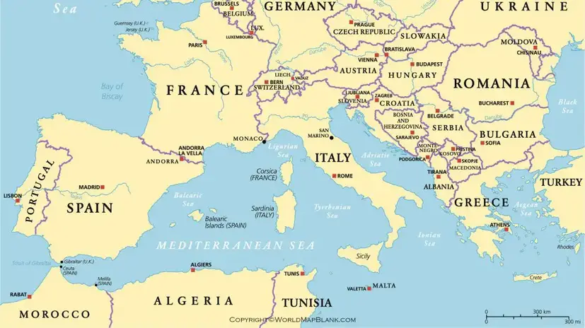
A printable map can also be useful for creating geography exercises, including:
- Identifying Mediterranean countries
- Locating major islands
- Labeling surrounding seas
- Identifying Europe, Africa, and Asia
- Studying major maritime routes
- Comparing Mediterranean countries and coastlines
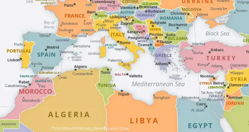
Mediterranean Countries and Geography
The Mediterranean coastline contains countries from three continents.
Europe: Spain, France, Monaco, Italy, Slovenia, Croatia, Bosnia and Herzegovina, Montenegro, Albania, Greece, and Malta.
Asia: Turkey, Cyprus, Syria, Lebanon, Israel, and the Palestinian territories.
Africa: Egypt, Libya, Tunisia, Algeria, and Morocco.
Some broader definitions of the Mediterranean region also include countries that do not directly border the Mediterranean Sea because of their geographic, climatic, historical, or cultural connections to the region.
Major Islands in the Mediterranean Sea
The Mediterranean Sea contains many important islands and island groups. Some of the best-known include:
- Sicily
- Sardinia
- Corsica
- Crete
- Cyprus
- Malta
- Rhodes
- Mallorca
- Menorca
- Ibiza
Sicily is the largest island in the Mediterranean Sea. Cyprus is another major Mediterranean island located in the eastern part of the sea.
Mediterranean Sea Geography
The Mediterranean has a distinctive geography shaped by its surrounding landmasses and connections to other bodies of water.
The Strait of Gibraltar forms its western connection with the Atlantic Ocean. At the eastern end, the Mediterranean connects with the Levantine region, while the Suez Canal provides an artificial connection toward the Red Sea.
The sea contains several deep basins and numerous smaller seas. Its coastline includes major ports and historically important maritime centers.
Mediterranean Climate
The Mediterranean region is also associated with the Mediterranean climate, although this climate does not cover every area surrounding the sea.
A typical Mediterranean climate has:
- Hot, relatively dry summers
- Mild, wetter winters
- Seasonal rainfall concentrated mainly during the cooler months
The climate is particularly associated with parts of southern Europe, North Africa, western Turkey, and other regions around the Mediterranean basin.
Why Use a Mediterranean World Map?
A Mediterranean world map is useful for understanding the geographic relationship between three continents. It can help users:
- Locate Mediterranean countries
- Identify the Mediterranean Sea
- Study major islands and seas
- Understand the relationship between Europe, Africa, and Asia
- Learn about important maritime routes
- Support geography assignments and classroom activities
- Plan travel across Mediterranean destinations
Mediterranean Map for Students and Teachers
Teachers can use a map of Mediterranean world for geography lessons, worksheets, quizzes, and classroom discussions.
Students can use a printable map to practice locating countries and physical features. A blank Mediterranean map can also be used as a labeling exercise where students identify countries, islands, seas, and surrounding continents themselves.
Mediterranean Sea: Quick Facts
| Fact | Information |
|---|---|
| Location | Between Europe, Africa, and Asia |
| Ocean connection | Atlantic Ocean |
| Western gateway | Strait of Gibraltar |
| Approximate area | 2.5 million km² |
| Major artificial connection | Suez Canal |
| Largest island | Sicily |
| Surrounding continents | Europe, Africa, Asia |
| Climate association | Mediterranean climate |
| Major regions | Western, Central, and Eastern Mediterranean |
Map of Mediterranean World: Important Facts
The Mediterranean is not simply a sea separating Europe and Africa. It has played an important role in trade, migration, agriculture, navigation, cultural exchange, and the development of civilizations for thousands of years.
Ancient civilizations including the Egyptians, Greeks, Phoenicians, Romans, and others developed important settlements and trading networks around the Mediterranean.
Today, the Mediterranean remains an important region for international shipping, tourism, fisheries, agriculture, energy infrastructure, and regional trade.
How to Use the Printable Mediterranean Map
You can use the printable map for both digital and educational purposes:
- Open the map image or PDF.
- Download the printable version.
- Print it on your preferred paper size.
- Use it to identify countries, islands, and seas.
- Add labels or notes for geography practice.
For digital learning, the high-resolution map can also be viewed on a computer, tablet, or mobile device.
Frequently Asked Questions About the Map of Mediterranean World
What is the Mediterranean world?
The Mediterranean world generally refers to the geographic region surrounding the Mediterranean Sea, including parts of Europe, North Africa, and western Asia.
Which countries border the Mediterranean Sea?
Countries with Mediterranean coastlines include Spain, France, Monaco, Italy, Slovenia, Croatia, Bosnia and Herzegovina, Montenegro, Albania, Greece, Turkey, Cyprus, Syria, Lebanon, Israel, Egypt, Libya, Tunisia, Algeria, and Morocco, along with the Palestinian territories.
Which continents surround the Mediterranean Sea?
The Mediterranean Sea lies between Europe, Africa, and Asia.
What is the largest island in the Mediterranean Sea?
Sicily, an autonomous region of Italy, is the largest island in the Mediterranean Sea.
Where is the Mediterranean Sea on a world map?
The Mediterranean Sea is located between southern Europe, northern Africa, and western Asia. It connects with the Atlantic Ocean through the Strait of Gibraltar.
Is the Mediterranean Sea connected to the Atlantic Ocean?
Yes. The Mediterranean Sea connects to the Atlantic Ocean through the Strait of Gibraltar.
Can I print the Mediterranean world map?
Yes. A printable Mediterranean world map can be used for classroom activities, geography study, assignments, and general reference.
What is the climate around the Mediterranean?
The Mediterranean region includes several climate types, but the Mediterranean climate is generally characterized by hot, dry summers and mild, wetter winters.
Why is the Mediterranean Sea important?
The Mediterranean has major geographic, historical, economic, cultural, and maritime importance. It connects regions of Europe, Africa, and Asia and contains important shipping routes and ports.









