

Looking for a United States map with states that you can download and print? Explore our collection of political USA maps in PDF format, including maps with state names, two-letter abbreviations, state capitals, major cities, and the Great Lakes.
These printable US maps are useful for students, teachers, geography enthusiasts, and anyone who needs a clear reference map of the United States. Choose the version that suits your needs and download the available PDF for printing or offline study.
You can also explore our blank map of the United States, US Interstate Highways Map, and United States map worksheets with capitals for additional learning resources.
USA Map with States
A USA map with states helps you identify the location, shape, and boundaries of all 50 US states. A political map focuses on administrative boundaries and place names rather than physical features such as mountains and elevation.
Our collection includes several versions of a United States map with states, from simple labeled maps to more detailed maps showing capitals, cities, and state abbreviations.
Choose a map based on your purpose:
- State names: Identify all 50 states by their full names.
- State abbreviations: Learn the official two-letter postal abbreviations.
- States and capitals: Study each state’s capital city.
- States and cities: Locate selected major US cities.
- Maps with the Great Lakes: See the Great Lakes alongside state boundaries.


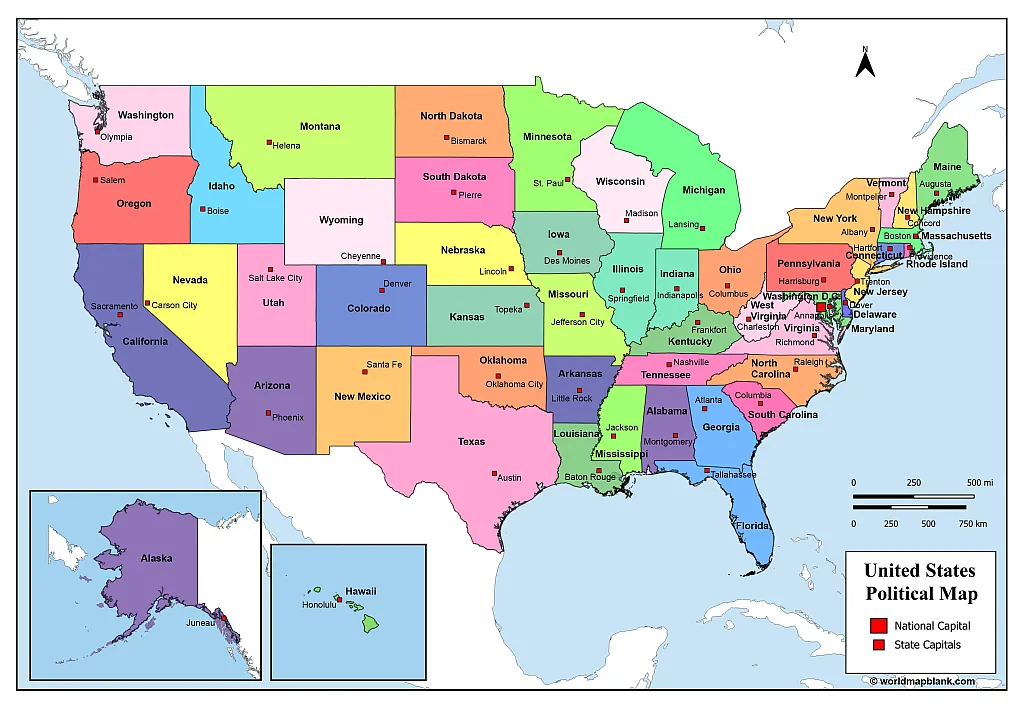
United States 50 States Map
This printable United States 50 states map displays the full names of the states. It is suitable for basic geography study, classroom activities, revision, and general reference.
This version does not include the Great Lakes. If you need a map that shows these lakes, use the alternative version in the next section.

Download as PDF (A4)
Download as PDF (A5)
A Brief History of the Original 13 States
The United States began as 13 British colonies that declared independence in 1776. These colonies later became the original states of the new nation.
The original 13 states were Delaware, Pennsylvania, New Jersey, Georgia, Connecticut, Massachusetts, Maryland, South Carolina, New Hampshire, Virginia, New York, North Carolina, and Rhode Island.
Delaware became the first state to ratify the US Constitution on December 7, 1787. It is often called the First State for this reason. The United States subsequently expanded to its present total of 50 states.
For historical verification, see the National Archives’ information on Constitution ratification.
USA Map with the States Names and Great Lakes
The following map is the same as the previousThis version of the USA map includes the full names of the states and the Great Lakes. It can help readers understand the relationship between the northern US states and the lakes along the US–Canada border. one, but it also includes the Great Lakes.
The five Great Lakes are Lake Superior, Lake Michigan, Lake Huron, Lake Erie, and Lake Ontario. Lake Michigan is the only Great Lake located entirely within the United States; the other four are shared by the United States and Canada.

Download as PDF (A4)
Download as PDF (A5)
If you need more geographic detail, compare this map with a physical map that shows mountains, rivers, and other landforms.
The First State of the United States
Delaware was the first state to ratify the US Constitution, doing so on December 7, 1787. Pennsylvania followed on December 12, 1787, and New Jersey ratified on December 18, 1787.
Today, the United States consists of 50 states. Each state has its own government, capital, and state-level laws, while also being part of the federal system.
Here is the complete list of the 50 US states in alphabetical order:
Alabama, Alaska, Arizona, Arkansas, California, Colorado, Connecticut, Delaware, Florida, Georgia, Hawaii, Idaho, Illinois, Indiana, Iowa, Kansas, Kentucky, Louisiana, Maine, Maryland, Massachusetts, Michigan, Minnesota, Mississippi, Missouri, Montana, Nebraska, Nevada, New Hampshire, New Jersey, New Mexico, New York, North Carolina, North Dakota, Ohio, Oklahoma, Oregon, Pennsylvania, Rhode Island, South Carolina, South Dakota, Tennessee, Texas, Utah, Vermont, Virginia, Washington, West Virginia, Wisconsin, and Wyoming.
For a state-specific reference, explore our California map, Florida map, Massachusetts map, Nebraska map, and Texas map.
United States Map with Abbreviations
A United States map with abbreviations shows each state using its standard two-letter postal abbreviation. This format is useful when studying US geography, reading addresses, or learning state codes.
For example, California is CA, Texas is TX, Florida is FL, and New York is NY. These abbreviations are standardized for postal use by the United States Postal Service (USPS).
The USPS introduced the current two-letter state abbreviations in October 1963, following the introduction of the five-digit ZIP Code. Nebraska’s abbreviation was changed from NB to NE in 1969 to avoid confusion with New Brunswick, Canada.

Download as PDF (A4)
Download as PDF (A5)
Major Geographic Regions of the United States
The United States is geographically diverse, with regions commonly described as the Northeast, Midwest, South, and West. Some educational maps divide the South into the Southeast and Southwest, depending on the classification used.
- Northeast: Includes states such as New York, Pennsylvania, Massachusetts, and Maine.
- Midwest: Includes Illinois, Ohio, Michigan, Wisconsin, and Minnesota.
- South: Includes states such as Georgia, Alabama, Tennessee, and Florida.
- West: Includes states such as California, Oregon, Washington, and Nevada.
Regional classifications can vary by source. For statistical consistency, consult the US Census Bureau’s geographic regions and divisions.
A labeled US map makes these regions easier to compare and helps learners understand the distribution of states across the country.
USA Map with States
A general USA map with states provides a simple view of the country’s state boundaries and locations. It is useful for reference, basic geography lessons, and activities that involve locating individual states.

Download as PDF (A4)
Download as PDF (A5)
When using a map for schoolwork, check whether you need state names, abbreviations, capitals, or city labels before printing. A simpler map is often easier to read when the goal is memorizing state locations.
United States Map Capitals
A United States map with capitals helps readers connect each state with its capital city. Capital cities are important administrative centers and are commonly included in geography lessons, quizzes, and reference materials.
A capital is not necessarily the state’s largest or best-known city. For example, Sacramento is the capital of California, while Los Angeles is its largest city by population. Similarly, Albany is the capital of New York, not New York City.
Our political United States map includes state names and capitals, making it a useful reference for learning these differences.
Complete List of US States and Their Capitals
| State | Capital |
|---|---|
| Alabama | Montgomery |
| Alaska | Juneau |
| Arizona | Phoenix |
| Arkansas | Little Rock |
| California | Sacramento |
| Colorado | Denver |
| Connecticut | Hartford |
| Delaware | Dover |
| Florida | Tallahassee |
| Georgia | Atlanta |
| Hawaii | Honolulu |
| Idaho | Boise |
| Illinois | Springfield |
| Indiana | Indianapolis |
| Iowa | Des Moines |
| Kansas | Topeka |
| Kentucky | Frankfort |
| Louisiana | Baton Rouge |
| Maine | Augusta |
| Maryland | Annapolis |
| Massachusetts | Boston |
| Michigan | Lansing |
| Minnesota | Saint Paul |
| Mississippi | Jackson |
| Missouri | Jefferson City |
| Montana | Helena |
| Nebraska | Lincoln |
| Nevada | Carson City |
| New Hampshire | Concord |
| New Jersey | Trenton |
| New Mexico | Santa Fe |
| New York | Albany |
| North Carolina | Raleigh |
| North Dakota | Bismarck |
| Ohio | Columbus |
| Oklahoma | Oklahoma City |
| Oregon | Salem |
| Pennsylvania | Harrisburg |
| Rhode Island | Providence |
| South Carolina | Columbia |
| South Dakota | Pierre |
| Tennessee | Nashville |
| Texas | Austin |
| Utah | Salt Lake City |
| Vermont | Montpelier |
| Virginia | Richmond |
| Washington | Olympia |
| West Virginia | Charleston |
| Wisconsin | Madison |
| Wyoming | Cheyenne |
Use this list alongside a labeled USA map to practice identifying each state and its capital.
Political United States Map
A political United States map highlights state boundaries, state names, and administrative locations. Unlike a physical map, which emphasizes terrain and elevation, a political map is designed to make borders and place names easy to identify.
The United States shares land borders with Canada to the north and Mexico to the south. The contiguous 48 states occupy the central portion of North America. Alaska lies northwest of Canada, while Hawaii is an island state in the Pacific Ocean.

Download as PDF (A4)
Download as PDF (A5)
The Great Lakes on a Political Map
The Great Lakes are Superior, Michigan, Huron, Erie, and Ontario. They form a major freshwater system along the United States–Canada border and are important for transportation, regional economies, ecosystems, and recreation.
When choosing a political map, look for a version that explicitly includes the Great Lakes if you need to study the geography of the northern states.
For additional geographic information, consult official resources such as the US Geological Survey.
USA Map with Great Lakes
This version of the USA map includes the Great Lakes alongside state boundaries and labels. It is helpful for identifying the states around the Great Lakes region and understanding the geography shared by the United States and Canada.

For best results, open the PDF before printing and check that the state names and lake labels remain readable at your chosen paper size.
USA Map with Abbreviations and Capitals
A USA map with abbreviations and capitals combines two useful kinds of information: postal state codes and the names or locations of state capitals.
This format is suitable for learners who already recognize the states and want to practice their abbreviations and capital cities together.

For students, a helpful activity is to cover the labels and use the map to identify states from their abbreviations, then check the answers using the full-label version.
United States Labeled Map
A United States labeled map makes it easier to identify state boundaries and place names without consulting a separate list. Depending on the version, labels may include full state names, abbreviations, capitals, or the Great Lakes.

For classroom use, you can pair a labeled map with a blank map of the United States to create labeling exercises and geography quizzes.
United States Map with States and Cities
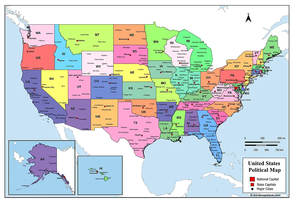
A United States map with states and cities provides a broader view of US geography by combining state boundaries with selected city locations. This can help readers understand where major urban centers are situated in relation to state borders.
City maps can be useful for geography projects, travel planning, classroom discussions, and general reference. However, the cities shown depend on the map version, and not every city or town will be labeled.

Largest US Cities by Population
According to the US Census Bureau’s July 1, 2024 city population estimates, the five most populous US cities within city limits were:
| Rank | City | State | Estimated population |
|---|---|---|---|
| 1 | New York City | New York | 8,478,072 |
| 2 | Los Angeles | California | 3,878,704 |
| 3 | Chicago | Illinois | 2,721,308 |
| 4 | Houston | Texas | 2,390,125 |
| 5 | Phoenix | Arizona | 1,673,164 |
Source: US Census Bureau — Vintage 2024 Population Estimates.
These figures refer to city populations, not metropolitan areas. Population rankings and estimates may change with subsequent releases.
How to Choose and Print a United States Map
Choosing the right map depends on how you intend to use it.
- For learning state locations: Choose a labeled map with all 50 state names.
- For studying state capitals: Select a political map that labels each capital.
- For postal codes: Use a map with official two-letter state abbreviations.
- For city geography: Choose a map that includes major city labels.
- For worksheets and quizzes: Pair a labeled map with a blank map.
- For the Great Lakes region: Select a version that explicitly shows all five lakes.
Frequently Asked Questions About the United States Map with States
1. How many states are there in the United States?
The United States has 50 states. Washington, DC, is the federal district and is not a state.
2. Can I download a United States map with states in PDF format?
Yes. The maps linked in this article include PDF options in A4 and A5 sizes. Open the relevant download link to access the file.
3. Which United States map is best for students?
A labeled map with all 50 state names is a good starting point. Students studying capitals can use a political map with capital labels, while blank maps are useful for practice and quizzes.
4. What is the difference between a political map and a physical map?
A political map emphasizes administrative boundaries, state names, and cities. A physical map emphasizes natural features such as mountains, rivers, plains, and elevation.
5. What are the official two-letter US state abbreviations?
They are standardized two-letter codes used for postal addresses. Examples include CA for California, TX for Texas, NY for New York, and FL for Florida. The USPS publishes the complete list.
6. What was the first state in the United States?
Delaware was the first state to ratify the US Constitution, on December 7, 1787.
7. Which states border the Great Lakes?
The US states bordering at least one of the Great Lakes are Minnesota, Wisconsin, Illinois, Indiana, Michigan, Ohio, Pennsylvania, and New York. The lakes also border Ontario, Canada.
8. What is the capital of the United States?
Washington, DC, is the capital of the United States. It is a federal district, not one of the 50 states.
9. Are state capitals always the largest cities in their states?
No. Many state capitals are not their state’s most populous city. For example, Sacramento is California’s capital, while Los Angeles is its largest city by population.
10. Where can I find an official list of US state abbreviations?
The USPS publishes the standard two-letter state abbreviations in its Postal Explorer reference.
Reference links
https://www.census.gov/newsroom/press-releases/2025/vintage-2024-popest.html
https://pe.usps.com/text/pub28/28apb.htm
https://about.usps.com/who/profile/history/state-abbreviations.htm
https://www.archives.gov/education/lessons/constitution-day/ratification.html
https://www.census.gov/programs-surveys/economic-census/guidance-geographies/levels.html
More Maps of the United States and the World
Please find below a collection of other topics that we offer printable maps for. All of our maps can be downloaded as PDF files for free. If the map you need is not listed here, just use our search function at the top of this page. In case you need a particular map that you cannot find at all on our site, please leave us a comment below and describe what you need. We might be able to create the map for you free of charge.
USA Maps
- Blank Map of the United States
- US Interstate Map
- Blank Map of New York
- Arizona Blank Map
- Blank map of Ohio
- Wisconsin Blank Map
Continent Maps
- Blank Map of South America
- Labeled Map of Europe
- Blank Map of Europe
- Asia Map with Countries
- Blank Asia Map
- Political Map of Africa
- Map of Australia with States and Cities

3 thoughts on “United States Map with States – Political USA Map [PDF]”