
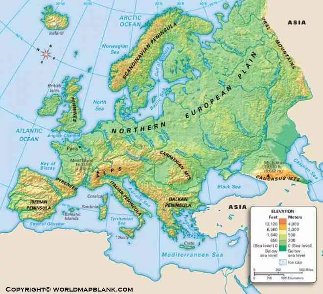

Explore the Europe Mountains Map to understand the continent’s major mountain ranges, famous peaks, and physical geography. This printable resource is useful for students, teachers, geography enthusiasts, researchers, travelers, and anyone studying the physical landscape of Europe.
Europe has a highly varied landscape, from the Alps and Pyrenees to the Carpathians, Caucasus, Scandinavian Mountains, and Balkan Mountains. A Europe Mountains Map makes it easier to identify these ranges and understand their locations relative to European countries.
- World coronavirus map
- World geographical map
- World Map Wallpaper
- Political Map of Europe
- World population map
- Labeled Map of Europe
- Accurate map of World
- Ancient World map
Map of Europe Mountains

Our Map of Europe Mountains provides a visual reference for exploring the continent’s major mountain regions. It can be used for geography lessons, classroom assignments, map-based research, trip planning, and general geographic reference.
What Can You Find on a Europe Mountains Map?
A detailed Europe Mountains Map can help identify:
- Alps
- Pyrenees
- Carpathian Mountains
- Apennine Mountains
- Scandinavian Mountains
- Balkan Mountains
- Dinaric Alps
- Caucasus Mountains
- Ural Mountains
- Scottish Highlands
- Cantabrian Mountains
- Sierra Nevada
- Pindus Mountains
The exact ranges and labels shown depend on the map’s scale and design.
Europe Mountains Map
The Europe Mountains Map is useful for understanding how Europe’s major mountain systems are distributed across the continent.

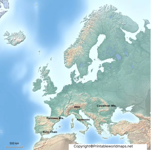
The Alps extend across several countries in central Europe, while the Pyrenees form a natural mountain barrier between Spain and France. The Carpathians curve through central and eastern Europe, and the Apennines form the mountainous backbone of much of Italy.
The Scandinavian Mountains dominate parts of Norway and Sweden, while the Caucasus forms an important mountain system between the Black Sea and Caspian Sea.
These mountain systems influence Europe’s climate, rivers, ecosystems, transportation routes, agriculture, tourism, and settlement patterns.
Europe Map with Mountains

A Europe Map with Mountains provides geographic context by showing mountain systems in relation to countries, seas, major cities, and other physical features.
This type of map is particularly useful when studying how Europe’s physical geography interacts with its political geography.
Major Mountain Ranges in Europe
| Mountain range | Main region | Notable high point |
|---|---|---|
| Alps | Central Europe | Mont Blanc |
| Pyrenees | Spain–France border | Aneto |
| Carpathians | Central & Eastern Europe | Gerlachovský štít |
| Apennines | Italy | Corno Grande |
| Scandinavian Mountains | Norway & Sweden | Galdhøpiggen |
| Caucasus | Between Black & Caspian Seas | Mount Elbrus |
| Balkan Mountains | Bulgaria & Serbia region | Botev Peak |
| Dinaric Alps | Southeastern Europe | Maja Jezercë |
| Pindus Mountains | Greece & Albania | Mount Smolikas |
| Cantabrian Mountains | Northern Spain | Torre Cerredo |
Printable Europe Mountains Map Labeled
A Printable Europe Mountains Map Labeled is particularly useful for students and teachers who need a physical geography reference for classroom activities, homework, presentations, and revision.
A labeled map can make it easier to locate major mountain ranges without requiring users to interpret an unlabeled physical map.
For printing, PDF is generally the most convenient format because it preserves the document layout and can be printed at an appropriate page size.
Uses of a Printable Europe Mountains Map
You can use a printable map for:
- Geography homework
- Classroom teaching
- School projects
- Geography quizzes
- Map-labeling exercises
- Physical geography study
- Travel research
- Educational presentations
- Reference material
- Homeschooling activities
Highest Mountains in Europe
One of the most common questions when studying Europe’s physical geography is which mountain is the highest.
Under the commonly used geographic convention that includes the Caucasus within Europe, Mount Elbrus is generally regarded as Europe’s highest mountain, at approximately 5,642 meters (18,510 feet) above sea level.
Mont Blanc, in the Alps, is approximately 4,806 meters high, although its measured summit elevation can vary because the ice and snow cap changes over time.
This distinction is important because lists of Europe’s highest mountains can differ depending on the geographic boundary used for Europe.
Major Mountain Regions of Europe
Alps
The Alps are one of Europe’s most important mountain systems. They extend across countries including France, Switzerland, Italy, Austria, Germany, Slovenia, Liechtenstein and Monaco.
The Alps are especially significant for tourism, skiing, biodiversity, hydrology, transportation and European geography.
Pyrenees
The Pyrenees form a natural mountain barrier between the Iberian Peninsula and the rest of continental Europe. They extend along the border region between Spain and France and include Andorra.
Carpathian Mountains
The Carpathians form a large arc across Central and Eastern Europe. They extend through or near countries including Slovakia, Poland, Ukraine, Romania and Serbia.
Apennine Mountains
The Apennines run through much of the Italian Peninsula and are an important feature of Italy’s physical geography.
The Scandinavian Mountains extend through Norway and Sweden and are closely associated with the rugged landscapes and fjords of Norway.
Caucasus Mountains
The Caucasus Mountains lie between the Black Sea and Caspian Sea. The range is particularly important when discussing Europe’s highest peaks because Mount Elbrus is located there.
Europe Mountains Map for Students
Students can use the Europe Mountains Map to learn:
- Where Europe’s major mountain ranges are located
- Which countries contain major mountain systems
- Where Europe’s highest peaks are found
- How mountain ranges relate to rivers and climate
- How physical geography affects settlement
- How Europe’s landscapes vary between regions
Teachers can also use a labeled map as a starting point for map quizzes and physical geography assignments.
Why Are Europe’s Mountains Important?
Europe’s mountain ranges are more than geographic landmarks. They have played an important role in shaping the continent.
Mountains influence:
Climate: High elevations generally experience lower temperatures and can affect precipitation patterns.
Rivers: Many major European rivers have sources or tributaries associated with mountainous regions.
Biodiversity: Mountain environments contain specialized habitats and species adapted to elevation and climate.
Tourism: The Alps, Pyrenees, Dolomites and other ranges attract visitors for hiking, skiing and sightseeing.
Transportation: Mountain passes, tunnels and valleys have historically influenced European travel and trade routes.
Human settlement: Elevation, climate, water availability and terrain have influenced where communities developed.
How to Use the Printable Europe Mountains Map
- Download the map in PDF or image format.
- Select the appropriate paper size for printing.
- Print the map at the required scale.
- Use the labels to identify major mountain ranges.
- Compare the physical map with a political map of Europe.
- Use the map for study, teaching, research, or reference.
Frequently Asked Questions
What is the Europe Mountains Map?
The Europe Mountains Map is a physical geography reference showing major mountain ranges and mountainous regions across Europe.
What are the major mountain ranges in Europe?
Major European mountain systems include the Alps, Pyrenees, Carpathians, Apennines, Scandinavian Mountains, Balkan Mountains, Dinaric Alps, Pindus Mountains and Caucasus Mountains.
What is the highest mountain in Europe?
Mount Elbrus is generally considered Europe’s highest mountain under the geographic convention that includes the Caucasus in Europe. Its elevation is approximately 5,642 meters.
Is Mont Blanc the highest mountain in Europe?
No. Mont Blanc is the highest mountain in the Alps and Western Europe, but Mount Elbrus is generally recognized as higher when the Caucasus is included within Europe.
Where are the Alps located?
The Alps extend across parts of France, Switzerland, Italy, Austria, Germany, Slovenia, Liechtenstein and Monaco.
Why is a Europe Mountains Map useful?
It helps users identify mountain ranges, understand Europe’s physical geography, study geographic relationships, and locate important peaks and mountainous regions.
Can I print the Europe Mountains Map?
Yes. A printable map can be downloaded and printed for classroom activities, geography projects, study, or personal reference.
Which mountain range is between Spain and France?
The Pyrenees form the principal mountain barrier between Spain and France and also extend through Andorra.
Are the Caucasus Mountains part of Europe?
The answer depends on the geographic convention used to define the Europe–Asia boundary. Under the commonly used convention that places the Greater Caucasus watershed within Europe, Mount Elbrus is Europe’s highest peak.
Geography Facts About Europe’s Mountains
Here are several useful facts for geography students:
- The Alps are one of the major mountain systems of central Europe.
- The Pyrenees separate the Iberian Peninsula from the rest of continental Europe.
- The Carpathians form a broad arc across Central and Eastern Europe.
- The Apennines extend along much of Italy.
- The Scandinavian Mountains are concentrated in Norway and Sweden.
- The Caucasus lies between the Black Sea and Caspian Sea.
- Mountain landscapes influence European climate, ecosystems, rivers and tourism.
- Elevation generally decreases temperature, producing different ecological zones at different heights.
- Many European mountain areas are important sources of freshwater.
- Mountain passes and valleys have historically influenced transportation and settlement.
Reference Links
https://www.britannica.com/place/Europe
https://www.britannica.com/place/Alps
https://www.britannica.com/place/Caucasus
https://www.britannica.com/place/Carpathian-Mountains
https://www.britannica.com/place/Pyrenees
https://www.britannica.com/place/Apennine-Range
https://www.britannica.com/place/Scandinavian-Mountains
