

Explore the Australia Mountains Map to discover the country’s major mountain ranges, famous peaks, and important landforms. This guide includes printable mountain maps, labeled map options, and PDF downloads for students, teachers, geography enthusiasts, and travelers.
Use these maps to identify mountain regions across Australia, understand where the highest peaks are located, and support geography lessons or personal travel planning.
Australia Mountains Map
The Australia Mountains Map provides a visual reference for exploring the country’s mountain geography. Use the map to identify mountain areas and understand their locations in relation to Australia’s states, territories, and surrounding landscapes.

Australia has extensive lowlands and plateaus, along with mountain ranges, rugged escarpments, volcanic landforms, and alpine environments. The eastern highlands contain many of the mainland’s best-known mountain regions.
According to Geoscience Australia, Mount Kosciuszko reaches 2,228 metres above sea level, making it the highest mountain on the Australian mainland. It is located in New South Wales within the Snowy Mountains region.
Map of Australia Mountains
The map of Australia mountains helps readers understand the distribution of major mountain regions across the country. Australia’s mountainous landscapes are especially notable in the east and southeast, although significant peaks and elevated landforms also occur elsewhere.

The Great Dividing Range extends for thousands of kilometres along eastern Australia. It includes a variety of uplands, plateaus, ranges, and mountain regions rather than one continuous wall of high peaks.
Mountain geography is important for understanding Australia’s natural environment. Elevated areas influence local weather conditions, support distinctive plant and animal communities, and contribute to the water catchments that supply rivers and surrounding regions.
Printable Australia Mountains Map Labeled
A printable Australia mountains map labeled with mountain names can make geography lessons easier to follow. Students can use it to locate mountain regions, compare their positions, and develop a better understanding of Australia’s physical geography.

Some important mountain regions and peaks to learn about include:
- Snowy Mountains: Located in southeastern New South Wales and known for containing Mount Kosciuszko.
- Australian Alps: An alpine region spanning parts of New South Wales, Victoria, and the Australian Capital Territory.
- Victorian Alps: A mountainous region that includes Mount Bogong, Victoria’s highest mountain.
- Great Dividing Range: A major system of highlands and ranges running along much of eastern Australia.
- Glass House Mountains: A distinctive group of volcanic landforms in Queensland.
- Blue Mountains: A well-known mountainous region west of Sydney, recognised for its sandstone landscapes and deep valleys.
Use the labeled map alongside a physical or topographic map when you need more detail about elevation, terrain, and surrounding geographical features.
Mountains Map of Australia
The mountains map of Australia is useful for classroom activities, geography projects, revision, and general reference. You can view the image on a computer or mobile device, or print the PDF for offline use.
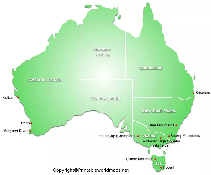
Before printing, check whether the map includes the labels and geographical details you need. A general mountain map is suitable for identifying major regions, while a topographic map is more appropriate for studying elevation, contour lines, and terrain.
Seven Famous Australian Peaks and Mountain Areas
1. Mount Kosciuszko, New South Wales
Mount Kosciuszko is the highest peak on mainland Australia at 2,228 metres. It lies within Kosciuszko National Park and is a major destination for walking and alpine scenery.
2. Mount Townsend, New South Wales
Mount Townsend reaches approximately 2,209 metres and is one of Australia’s highest mainland peaks. It is located near Mount Kosciuszko in the Snowy Mountains.
3. Mount Twynam, New South Wales
Mount Twynam is approximately 2,195 metres high and forms part of the high mountain country in the Snowy Mountains region.
4. Mount Bogong, Victoria
At approximately 1,986 metres, Mount Bogong is the highest mountain in Victoria. It is located in the Alpine National Park and is known for its challenging hiking routes and alpine environment..5. Mount Ossa, Tasmania
Mount Ossa rises to approximately 1,617 metres and is Tasmania’s highest mountain. It lies within the Cradle Mountain–Lake St Clair National Park area.
6. Mount Bartle Frere, Queensland
Mount Bartle Frere reaches approximately 1,611 metres and is Queensland’s highest mountain. It is located in the tropical rainforest region of northeastern Queensland.
7. Mount Zeil, Northern Territory
Mount Zeil reaches approximately 1,531 metres and is the highest mountain in the Northern Territory. It is located in the MacDonnell Ranges region of central Australia.
Elevation figures are rounded and may vary slightly between mapping and surveying sources.
Why Are Australia’s Mountains Important?
Australia’s mountains are valuable for more than their scenery. They help shape regional ecosystems, support biodiversity, and contribute to important water catchments.
The Australian Alps contain distinctive alpine plants and animals adapted to cold conditions. Snowfall and seasonal snowmelt in the high country also contribute to river systems in southeastern Australia.
Mountain regions also provide opportunities for hiking, skiing, nature study, photography, and environmental education. When visiting these areas, check current park alerts, weather conditions, access restrictions, and walking-track information before setting out.
How to Use and Print the Australia Mountains Map
Follow these steps to get the most from the printable maps:
- Choose the PNG image if you want to view the map quickly or use it in a digital presentation.
- Select the PDF version if you want a document that is convenient to print.
- Check the map labels and confirm that the required mountain names are visible.
- Print using a suitable paper size and landscape or portrait orientation, depending on the map’s proportions.
- Use a current atlas or authoritative topographic map to verify elevations and precise locations.
These printable resources can support school assignments, geography quizzes, classroom displays, and personal reference.
Frequently Asked Questions
1. What is the highest mountain in Australia?
Mount Kosciuszko, at 2,228 metres above sea level, is the highest mountain on mainland Australia. Australia’s external territories include higher summits, such as Mawson Peak on Heard Island.
2. Where are most of Australia’s highest mountains located?
Most of Australia’s highest mainland peaks are concentrated in the Snowy Mountains region of New South Wales, near the Victorian Alps. These regions form part of the Great Dividing Range.
3. What is the Great Dividing Range?
The Great Dividing Range is an extensive system of highlands, plateaus, and mountain ranges along eastern Australia. It influences drainage patterns and includes many important mountain regions.
4. Which mountain is the highest in Victoria?
Mount Bogong is the highest mountain in Victoria, reaching approximately 1,986 metres above sea level.
5. Which mountain is the highest in Tasmania?
Mount Ossa is Tasmania’s highest mountain, with an elevation of approximately 1,617 metres.
6. Can I download the Australia Mountains Map for free?
The PNG and PDF files linked in this article are provided as map resources. Check the terms on the source website before reusing or redistributing them.
7. How can I use a printable Australia mountains map for school?
You can use a printable map to identify mountain regions, practise locating peaks, prepare geography worksheets, and compare mountain locations with states and territories. A labeled map is useful for learning names, while a topographic map provides more detailed terrain information.
8. What is the difference between a mountain map and a topographic map?
A mountain map highlights mountain ranges or peaks. A topographic map shows terrain and elevation in greater detail, often using contour lines, spot heights, and other geographic symbols.
Reference links
https://www.ga.gov.au/scientific-topics/national-location-information/landforms/highest-mountains
https://www.dcceew.gov.au/parks-heritage/heritage/places/national/australia-alps
https://www.nationalparks.nsw.gov.au/things-to-do/lookouts/mount-kosciuszko-summit-lookout
https://www.parks.vic.gov.au/places-to-see/parks/alpine-national-park/attractions/mount-bogong
More Free and Printable Maps for Download
Below you’ll find a link collection to other interesting maps of different parts of the world. We offer world maps, country and continent maps as well as physical and other maps. All our maps are available for free download as PDF files.
World Maps
Continent Maps
- Political Map of Europe
- Blank Map of Europe
- Labeled Map of Africa
- Blank Map of South America
- Labeled Map of South America
- Blank Map of Asia
- Political Map of Asia
- Physical Map of Asia
- Labeled Map of South America
- Labeled Map of Europe

2 thoughts on “Australia Mountains Map – Map of Australia Mountains”