


The Labeled Map of Bahrain helps you locate the country’s capital, major cities, islands, and administrative governorates. Whether you are studying Middle Eastern geography, preparing a school project, or looking for a printable reference, these maps provide a convenient way to explore Bahrain.
Bahrain, officially known as the Kingdom of Bahrain, is an island country in the Arabian Gulf, also widely called the Persian Gulf. Its capital is Manama, and its territory includes the main island of Bahrain and several smaller islands. The country is connected to Saudi Arabia by the King Fahd Causeway.
On this page, you can explore a labeled map of Bahrain, a map showing its governorates, a map of major cities, and a map identifying the national capital. Printable PDF versions are also available for convenient offline use.
Labeled Map of Bahrain

A labeled map of Bahrain helps readers understand the country’s location, island geography, and important settlements. The main island contains Manama and many of the country’s major urban areas, while smaller islands form part of the wider national territory.
Bahrain lies east of Saudi Arabia and west of Qatar. Its location in the Arabian Gulf has contributed to its historic role in regional trade and maritime activity.
The following geographic facts provide additional context for reading the map:
- Official name: Kingdom of Bahrain
- Capital city: Manama
- Region: Middle East, Western Asia
- Land area: Approximately 786.8 square kilometres, according to Bahrain’s official government figures
- Official language: Arabic
- Currency: Bahraini dinar (BHD)
- Time zone: Arabian Standard Time (UTC+3)
Labeled Map of Bahrain with States

Bahrain is divided into four governorates, which are the country’s principal administrative divisions. They are the Capital Governorate, Muharraq Governorate, Northern Governorate, and Southern Governorate.
Older maps and articles may refer to five governorates because Bahrain previously had a Central Governorate. The administrative structure changed in 2014, so current maps should show the four-g governorate system rather than the former five-governorate arrangement.
The four governorates are:
- Capital Governorate: Includes Manama, the national capital and an important commercial centre.
- Muharraq Governorate: Includes Muharraq Island and surrounding urban areas.
- Northern Governorate: Covers communities in the northern part of Bahrain.
- Southern Governorate: Includes southern communities and a comparatively extensive area of land.
A governorate map is useful for understanding administrative boundaries, locating communities, and distinguishing the country’s main regions. Keep in mind that governorates are not equivalent to states in countries with a federal system.
Labeled Map of Bahrain with Cities
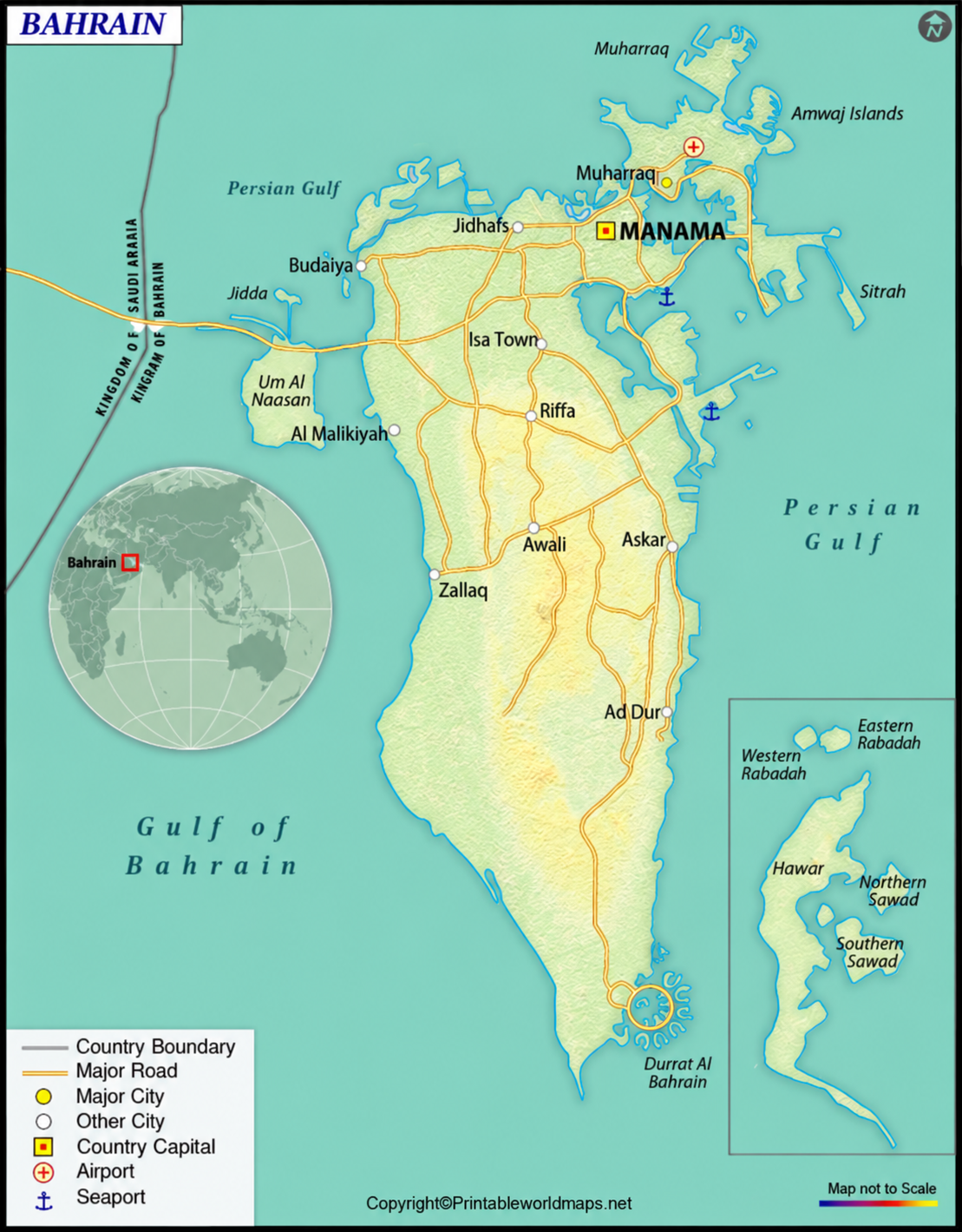
The labeled map of Bahrain with cities helps readers identify important urban areas and understand how settlements are distributed across the islands. Manama is the capital, while Muharraq, Riffa, Isa Town, Hamad Town, and Sitra are among the country’s other well-known urban areas.
Major cities and towns to look for on a Bahrain map include:
- Manama: The national capital and a major financial and commercial centre.
- Muharraq: A historic urban centre on Muharraq Island.
- Riffa: A major urban area in the southern part of the country.
- Hamad Town: A planned residential community.
- Isa Town: An established urban community.
- Sitra: An island and urban area associated with industrial and residential development.
- A’ali: A settlement known for its traditional pottery heritage.
- Jidhafs: An urban locality in northern Bahrain.
- Budaiya: A settlement along Bahrain’s northwestern coast.
- Al-Malikiyah: A community in western Bahrain.
Population figures for individual cities can vary depending on the year, administrative boundaries, and whether a source counts a municipality or a wider urban area. For accuracy, use dated official statistics rather than treating older figures as current.
Labeled Bahrain Map with Capital

Manama is the capital of Bahrain and one of its most important urban centres. Located on the northeastern side of Bahrain Island, the city plays a central role in the country’s government, finance, commerce, and tourism.
Manama has developed into a modern Gulf city while retaining connections to Bahrain’s maritime and trading history. Its landmarks, commercial districts, cultural attractions, and waterfront developments make it an important destination for visitors.
The country’s historical economy included fishing, pearling, boatbuilding, and trade. The discovery and development of petroleum helped transform Bahrain’s economy, contributing to industrial growth and modern infrastructure.
When reading a capital map, look for Manama in the northeastern part of the main island. Its position also helps explain the concentration of transport links, commercial districts, and other urban developments in northern Bahrain.
Bahrain Geography and Location
Bahrain is an archipelago in the Arabian Gulf. Its geography includes the main island, smaller islands, coastal areas, and reclaimed land. The country has no land border with another nation, but the King Fahd Causeway provides a road connection to Saudi Arabia.
The country’s geographical location has influenced its history as a centre for maritime trade, pearl fishing, and regional commerce. Today, Bahrain combines urban development and modern transport infrastructure with its coastal and island landscape.
For a broader geographic perspective, a regional map can help readers locate Bahrain in relation to Saudi Arabia, Qatar, and other Gulf countries.
Interesting Facts About Bahrain
Here are several useful facts to help you understand Bahrain’s geography and national profile:
- An island nation: Bahrain consists of a main island and numerous smaller islands.
- A capital in the northeast: Manama is located on the northeastern side of Bahrain Island.
- Four governorates: The current administrative divisions are Capital, Muharraq, Northern, and Southern.
- A road connection to Saudi Arabia: The King Fahd Causeway links Bahrain with Saudi Arabia.
- Arabic is the official language: English is also commonly used in business.
- The Bahraini dinar: Bahrain’s official currency is the Bahraini dinar (BHD).
- A diverse population: Bahrain’s official 2024 statistics recorded a total population of 1,588,670, including Bahraini and non-Bahraini residents.
Population and administrative information can change over time. Consult official government sources for the latest available figures before using them in reports, publications, or school assignments.
How to Use and Print the Bahrain Maps
These labeled maps can support geography lessons, educational projects, presentations, and general reference.
- Choose the map that matches your needs: general geography, governorates, cities, or the capital.
- Open the PNG image to view it at a larger size.
- Select the corresponding PDF link if you want a printable document.
- Use the map labels to identify locations and compare the country’s administrative and urban geography.
For the clearest print result, choose a suitable paper size and check the preview before printing. The final image quality depends on the resolution of the original file.
Frequently Asked Questions About Bahrain Maps
What is the capital of Bahrain?
Manama is the capital of the Kingdom of Bahrain. It is located on the northeastern side of Bahrain Island and is a major centre for government, finance, and commerce.
How many governorates does Bahrain have?
Bahrain has four governorates: Capital, Muharraq, Northern, and Southern. The country previously had five governorates, but the Central Governorate was removed as part of the 2014 administrative reorganisation.
What are the major cities in Bahrain?
Major urban areas include Manama, Muharraq, Riffa, Hamad Town, Isa Town, Sitra, A’ali, Jidhafs, Budaiya, and Al-Malikiyah. The classification of a place as a city or town may differ between sources.
Can I download a printable map of Bahrain?
Yes. The map sections above include PNG images and links to PDF versions. Open the relevant PDF link to view or print the map.
Where is Bahrain located?
Bahrain is an island country in the Arabian Gulf, in Western Asia. It lies east of Saudi Arabia and west of Qatar.
What is the difference between a Bahrain states map and a governorates map?
Bahrain uses governorates as its principal administrative divisions rather than states. A map described as a states map may use informal wording, but the current official administrative structure consists of four governorates.
What is the land area of Bahrain?
Bahrain’s official government figures list its land area as approximately 786.8 square kilometres. This is different from its total area when territorial waters are included.
Which language is spoken in Bahrain?
Arabic is the official language. English is also commonly used in business and commercial settings.
Reference links
https://www.bahrain.gov.bh/wps/portal/en/BNP/BahrainAtAGlance/AboutBahrain
https://www.data.gov.bh/explore/dataset/02-area-by-governorate-2023/?flg=en-gb
https://data.gov.bh/pages/statistics-page/?flg=en-gb
https://unstats.un.org/unsd/publications/pocketbook/files/world-stats-pocketbook-2024.pdf
