
The Missouri River Map helps you explore the course, location, tributaries, drainage basin, and major geographical features of the Missouri River, the longest river in the United States. Stretching approximately 2,341 miles (3,767 km) from its headwaters in the Rocky Mountains of Montana to its confluence with the Mississippi River near St. Louis, Missouri, the river plays a vital role in transportation, agriculture, wildlife, flood management, and recreation. This guide includes a detailed Missouri River Map, printable maps, location information, and fascinating geographical facts.
Missouri River Map
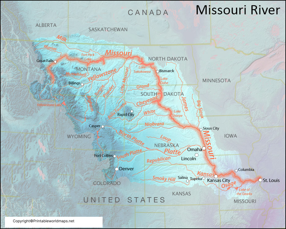
A detailed Missouri River Map illustrates the river’s entire course, beginning at the confluence of the Jefferson, Madison, and Gallatin Rivers near Three Forks, Montana. It flows through Montana, North Dakota, South Dakota, Nebraska, Iowa, Kansas, Missouri, and eventually joins the Mississippi River just north of St. Louis.
The Missouri River basin covers approximately 529,350 square miles (1.37 million km²), making it one of the largest drainage basins in North America. The watershed extends across 10 U.S. states and parts of Alberta and Saskatchewan in Canada, supplying water to millions of people while supporting agriculture, hydroelectric power, and diverse ecosystems.
Where is the Missouri River Located on a Map
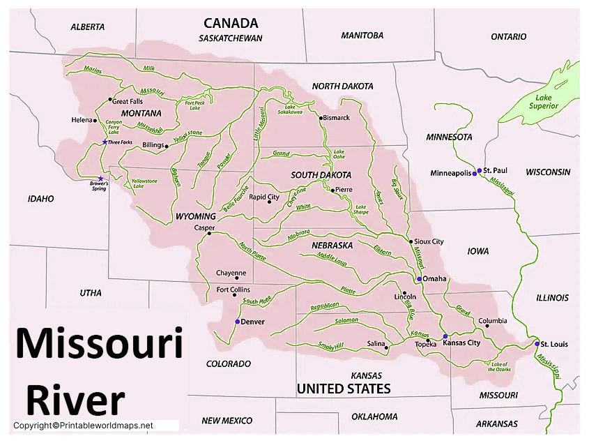
The Missouri River Map shows the river beginning in southwestern Montana before flowing generally southeast across the Great Plains. It passes through or forms the borders of several states before emptying into the Mississippi River in Missouri.
States Through Which the Missouri River Flows
- Montana
- North Dakota
- South Dakota
- Nebraska
- Iowa (border)
- Kansas (border)
- Missouri
The river serves as an important natural boundary between several states and has historically been a major transportation and trade route.
Missouri River Tributaries Map
The Missouri River Map highlights its extensive tributary system, which includes more than 95 major tributaries and hundreds of smaller streams.
Major Tributaries
- Yellowstone River
- Platte River
- Milk River
- James River
- White River
- Niobrara River
- Little Missouri River
- Osage River
- Big Sioux River
- Grand River
- Kansas River
Among these, the Yellowstone River is the longest free-flowing tributary in the contiguous United States, while the Platte River contributes significant water from the Rocky Mountains.
Labeled Missouri River Map Printable
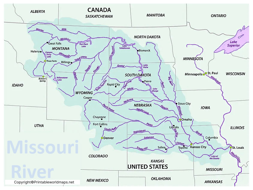
A labeled Missouri River Map printable is useful for:
- Geography education
- School assignments
- Classroom activities
- River basin studies
- Environmental research
- Travel planning
- Wall maps and presentations
Printable versions clearly display the river’s source, tributaries, surrounding states, major cities, dams, and drainage basin.
Missouri River Basin and Drainage
The Missouri River drains nearly one-sixth of the continental United States. Its basin stretches from the Rocky Mountains in the west to the Mississippi River Valley in the east.
The river system supports:
- Agricultural irrigation
- Municipal water supplies
- Hydroelectric dams
- Commercial navigation
- Wildlife habitats
- Flood control projects
- Recreation and tourism
Major reservoirs along the river include Fort Peck Lake, Lake Sakakawea, Lake Oahe, and Lewis and Clark Lake.
Map of Missouri River
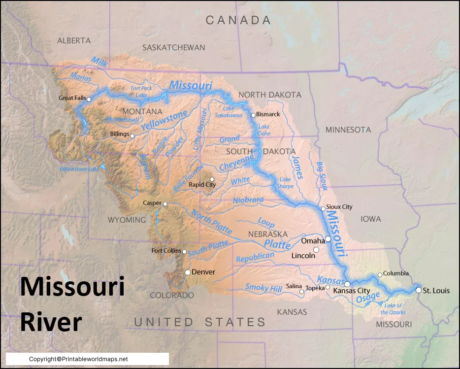
The Niobrara River is about 568 miles long and passes through Wyoming and Nebraska. Moreover, it drains most of the arid parts of the Great Plains. The Little Missouri River is about 560 miles long in the northern Great Plains of the US. It is also one of the major tributaries of the Missouri River. The Osage River is about 276 miles long in central Missouri. Besides that, it is the eighth-most extended river in the state. It drains about 15,300 square miles.
Its watershed includes Kansas and a large part of west-central and central Missouri. It drains northwest of the Ozark Plateau. The Missouri River map is significant for tourism and recreational activities. It is necessary to check for droughts and floods. Human activities also affect water quality. It is essential to check the level of water for irrigating the fields.
Missouri River Facts
Here are some interesting facts about the Missouri River:
- The Missouri River is approximately 2,341 miles (3,767 km) long.
- It is the longest river in North America by main stem length.
- The Missouri-Mississippi river system forms the fourth-largest river system in the world by length.
- The river basin covers around 529,350 square miles.
- More than 10 million people depend on the Missouri River Basin for drinking water.
- The river helped shape the historic Lewis and Clark Expedition (1804–1806).
- Several large hydroelectric dams generate renewable energy along the river.
Why is the Missouri River Important?
The Missouri River Map is valuable for understanding one of North America’s most significant waterways. It helps researchers, students, travelers, and environmental professionals study:
- River geography
- Flood-prone regions
- Navigation routes
- Watershed management
- Water conservation
- Ecosystem protection
- Fishing and boating areas
- National parks and recreation sites
The river continues to play a major role in agriculture, commerce, hydroelectric power generation, biodiversity conservation, and tourism throughout the central United States.
Frequently Asked Questions (FAQs)
How long is the Missouri River?
The Missouri River is approximately 2,341 miles (3,767 km) long.
Where does the Missouri River start?
It begins near Three Forks, Montana, where the Jefferson, Madison, and Gallatin Rivers meet.
Where does the Missouri River end?
The river joins the Mississippi River just north of St. Louis, Missouri.
Which is the largest tributary of the Missouri River?
The Yellowstone River is the longest major tributary, while the Platte River is among the largest by drainage contribution.
Why is the Missouri River famous?
It is famous for being the longest river in the United States, its role in westward expansion, the Lewis and Clark Expedition, hydroelectric dams, agriculture, and wildlife habitats.









