
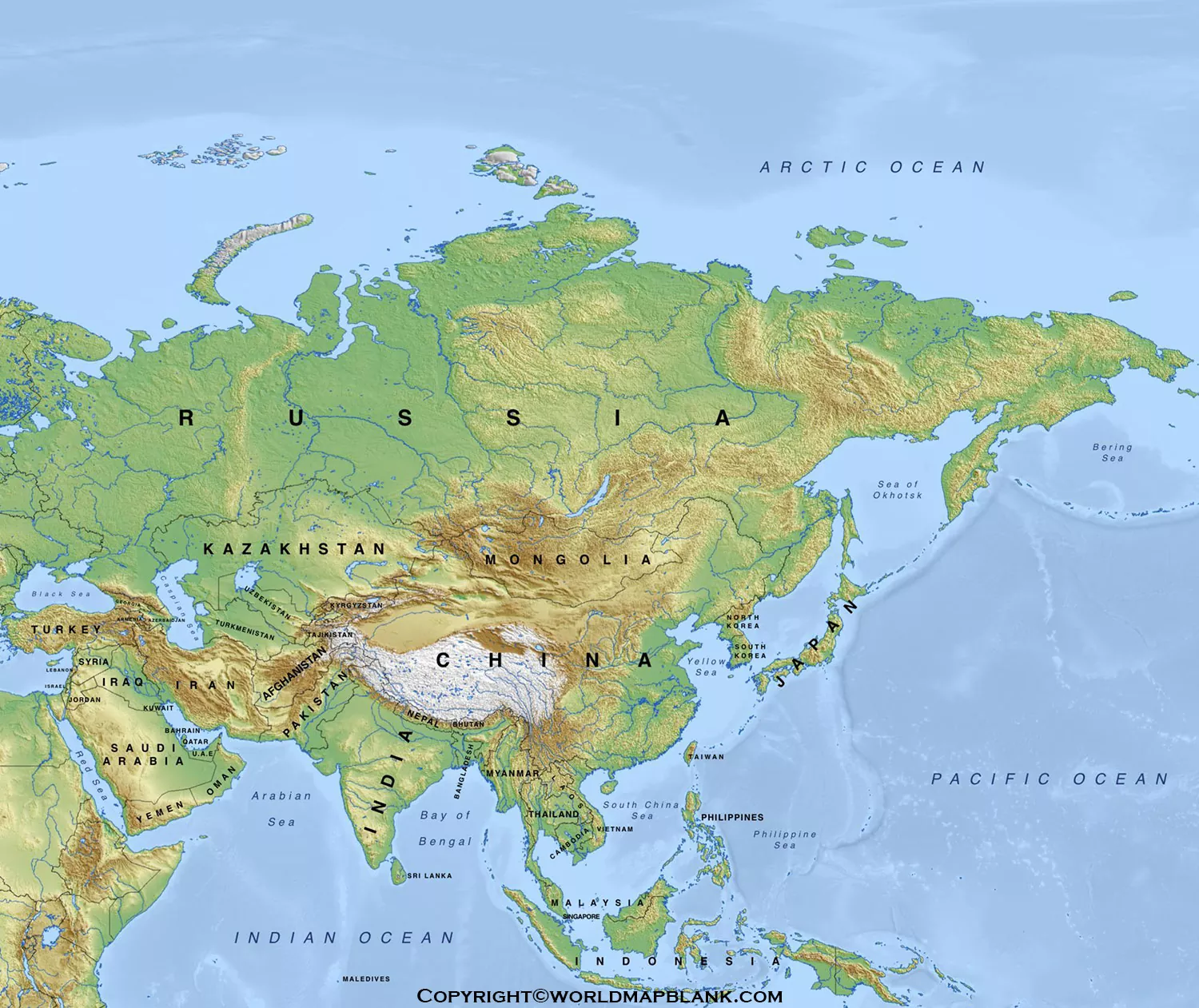
A Printable Asia Physical Map is a useful resource for studying the continent’s major natural features, including mountains, plateaus, plains, deserts, rivers, lakes, and surrounding oceans. This page provides printable map resources and PDF versions that can be used for geography lessons, classroom activities, homework, research, and general reference.
Asia is the largest continent by land area and the world’s most populous continent. It covers approximately 30% of Earth’s land area and is home to roughly 60% of the world’s population.
A physical map focuses primarily on natural geography rather than political boundaries. It helps readers identify elevation patterns, mountain systems, waterways, deserts, plateaus, plains, and other major physical features.
Asia Physical Map
Asia occupies the eastern portion of the Eurasian landmass. It is bordered by the Arctic Ocean to the north, the Pacific Ocean to the east, and the Indian Ocean to the south. The commonly used western geographic boundary includes features such as the Ural Mountains, Caucasus Mountains, Caspian Sea, and Black Sea.
The continent has an exceptionally varied physical landscape. Its geography includes some of Earth’s highest mountains, extensive plateaus and plains, large deserts, major river systems, and deep freshwater lakes.

What Does a Physical Map of Asia Show?
A physical map can help identify:
- Mountain ranges and high peaks
- Plateaus and elevated regions
- Plains and lowlands
- Deserts and arid regions
- Major rivers and lakes
- Seas and surrounding oceans
- Important physical regions
- Elevation and terrain patterns
These features make a Printable Asia Physical Map particularly useful for students who need a visual way to understand Asian geography.
Printable Asia Physical Map
The printable map can be used for classroom instruction, geography assignments, homeschooling, study notes, presentations, and personal reference.
For better results when printing, choose a high-resolution version and select Fit to Page or a similar printer setting. A PDF version is generally preferable when you want to retain the map’s layout and text quality.

Physical Map of Asia
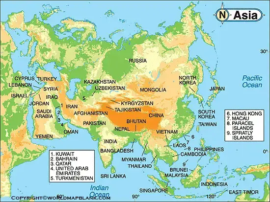
A Physical Map of Asia represents the continent’s major landforms and bodies of water. Unlike a political map, which emphasizes countries and borders, a physical map is designed to make natural geographic features easier to recognize.
Major Mountain Systems
Asia contains many of the world’s highest mountain systems. The Himalayas are particularly important because they include Mount Everest, the highest point on Earth. The Himalayas extend for roughly 2,400–2,500 kilometers across South Asia.
Other important mountain systems include:
- Himalayas
- Hindu Kush
- Tien Shan
- Kunlun Mountains
- Altai Mountains
- Ural Mountains
- Caucasus Mountains
The Himalayas were formed through the continuing interaction of the Indian and Eurasian tectonic plates. This tectonic activity continues to influence the region’s landscape.
Map of Asia Physical

Mount Everest
Mount Everest is the highest point on Earth, with an elevation of approximately 8,850 metres (29,035 feet). It forms part of the Himalaya range along the Nepal–China border region.
This makes the Himalayas one of the most important features to identify when studying a physical map of Asia.
Major Plateaus of Asia
Asia contains several large and geographically important plateaus.
Tibetan Plateau
The Tibetan Plateau is one of the most prominent high-elevation regions in Asia. It has an average elevation of more than 4,500 metres and is often called the “Rooftop of the World.” Its glaciers and snowfields contribute water to several major Asian river systems.
Deccan Plateau
The Deccan Plateau covers a large part of southern India. Its major rivers include the Godavari and Krishna, which flow toward the Bay of Bengal.
Iranian Plateau
The Iranian Plateau extends across much of Iran and parts of Afghanistan and Pakistan. It includes mountainous areas, river basins, and major desert regions.
Major Rivers of Asia
Asia has some of the world’s most important river systems. Major rivers shown or associated with physical maps of Asia include:
- Yangtze
- Yellow River
- Ganges
- Brahmaputra
- Indus
- Mekong
- Tigris
- Euphrates
- Ob
- Yenisei
- Lena
The Yangtze River is the longest river in Asia, extending approximately 6,300 kilometres from the Tibetan Plateau to the East China Sea.
The Ganges, Brahmaputra, Indus, Mekong, Yellow River, and other major waterways are also important physical features because they support ecosystems, agriculture, settlements, transportation, and economic activity across different parts of Asia.
Major Deserts in Asia
Asia contains extensive arid and semi-arid landscapes. Important deserts include:
- Gobi Desert
- Arabian Desert
- Taklamakan Desert
- Thar Desert
- Karakum Desert
- Kyzylkum Desert
- Dasht-e Kavir
- Dasht-e Lut
The Gobi Desert, located mainly in Mongolia and northern China, is one of Asia’s best-known desert regions.
Lakes and Freshwater Features
Asia also contains significant freshwater resources.
Lake Baikal, located in southern Russia, is the world’s deepest lake, reaching approximately 1,620 metres (5,315 feet) at its deepest point. It contains around 20% of the world’s unfrozen freshwater and is also one of Earth’s oldest lakes.
Other notable lakes and inland water bodies associated with Asia include:
- Caspian Sea
- Aral Sea
- Lake Balkhash
- Dead Sea
- Lake Baikal
Oceans and Seas Around Asia
The physical geography of Asia is strongly influenced by surrounding water bodies.
The three major oceans bordering Asia are:
- Arctic Ocean — north
- Pacific Ocean — east
- Indian Ocean — south
Important seas and marginal waters include the Arabian Sea, Bay of Bengal, South China Sea, East China Sea, Yellow Sea, Sea of Japan, and Bering Sea.
Asia Physical Geography: 10 Key Facts
Here are useful facts to remember when studying a Printable Asia Physical Map:
- Asia is the world’s largest continent by land area.
- Asia contains approximately 30% of Earth’s land area.
- Asia is the world’s most populous continent.
- Approximately 60% of the world’s population lives in Asia.
- Mount Everest is Earth’s highest point.
- The Himalayas are one of Asia’s major mountain systems.
- The Tibetan Plateau is one of the world’s highest extensive plateaus.
- The Yangtze is the longest river in Asia.
- Lake Baikal is the world’s deepest lake.
- Asia contains environments ranging from Arctic landscapes to tropical regions.
Printable Map of Asia for Students
A printable physical map can be particularly helpful for students studying:
- Asian geography
- Continents and oceans
- Mountain ranges
- Major rivers
- Deserts and plateaus
- Physical features of India and Asia
- World geography
- Map-labeling exercises
- Geography quizzes
- School projects
Teachers can also use a blank or lightly labeled physical map for classroom exercises in which students identify major landforms and waterways.
How to Use a Printable Asia Physical Map
For effective geography study:
Step 1: Download the PDF map.
Step 2: Print it at the desired paper size.
Step 3: Identify the major mountain systems.
Step 4: Locate the major rivers and lakes.
Step 5: Find the major deserts and plateaus.
Step 6: Identify the surrounding oceans and seas.
Step 7: Compare the physical features with a political map of Asia.
This approach helps students understand how physical geography relates to the location of countries, cities, rivers, and population centers.
Digital and PDF Asia Physical Maps
The map resources on this page can be useful in both printed and digital formats. A PDF is convenient for downloading, printing, sharing with students, or keeping as a geography reference.
For digital study, users can view the map on a computer, tablet, or smartphone and zoom into individual physical features.
Frequently Asked Questions
What is a Printable Asia Physical Map?
A Printable Asia Physical Map is a map designed to show Asia’s natural geographic features, such as mountains, rivers, plateaus, deserts, lakes, seas, and elevation patterns.
What does a physical map of Asia show?
A physical map of Asia primarily shows natural features including mountain ranges, highlands, plateaus, plains, deserts, rivers, lakes, seas, and oceans.
What is the highest mountain in Asia?
Mount Everest is the highest mountain in Asia and the highest point on Earth, with an elevation of approximately 8,850 metres (29,035 feet).
What is the largest continent in the world?
Asia is the world’s largest continent by land area. It covers approximately 30% of Earth’s land area.
What is the longest river in Asia?
The Yangtze is the longest river in Asia, measuring approximately 6,300 kilometres.
What are the major physical features of Asia?
Major physical features include the Himalayas, Tibetan Plateau, Gobi Desert, West Siberian Plain, major Asian rivers, Lake Baikal, and surrounding oceans and seas.
Why is the Tibetan Plateau important?
The Tibetan Plateau is a major high-elevation region and an important source area for several Asian river systems. Its glaciers and snowfields contribute to freshwater resources across the continent.
Can I print the Asia physical map for school?
Yes. A printable physical map can be used for geography lessons, homework, map-labeling exercises, classroom activities, and school projects.
What is the difference between a physical map and a political map?
A physical map emphasizes natural features such as mountains, rivers, deserts, and elevation. A political map emphasizes human-made boundaries such as countries, states, and administrative regions.
Which oceans surround Asia?
Asia is bordered primarily by the Arctic Ocean in the north, Pacific Ocean in the east, and Indian Ocean in the south.
Reference link
https://education.nationalgeographic.org/resource/asia
https://education.nationalgeographic.org/resource/mount-everest
https://unstats.un.org/unsd/publications/pocketbook/files/world-stats-pocketbook-2024.pdf









