

A labeled map of Kyrgyzstan shows the country’s location in Central Asia, its international borders, capital, major cities, regions, and important geographic features. Kyrgyzstan is a landlocked country bordered by Kazakhstan to the north, Uzbekistan to the west, Tajikistan to the south, and China to the east.
Kyrgyzstan is officially known as the Kyrgyz Republic. The country is highly mountainous, with about 94% of its territory classified as mountainous. Its capital and largest city is Bishkek, while Osh is another major city and has republican significance.
The current official statistical information provides population data beginning with January 1, 2026, so older figures from 2020 should not be presented as current population data.
- World map with continents
- Physical world map
- Political world map
- Labeled map of Asia
- Labeled map of Africa
- Labeled map of Europe
- Labeled map of South America
- World time zone map
- Labeled map of World
- Blank map of world
- Labeled map of North America
- Blank map of Asia
- World map with oceans
- World map poster
Labeled Map of Kyrgyzstan
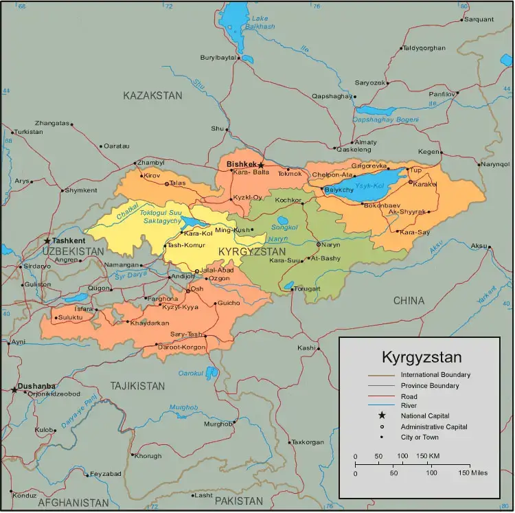
This labeled map of Kyrgyzstan can be used to identify the country’s position in Central Asia and understand its surrounding countries and major geographic areas.
Why Use a Labeled Kyrgyzstan Map?
A labeled map can be useful for:
- Geography lessons and classroom activities
- Identifying Kyrgyzstan’s neighboring countries
- Locating Bishkek and Osh
- Studying Kyrgyzstan’s administrative regions
- Learning the locations of major cities
- Travel and geographic research
- Printable school assignments and reference materials
Labeled Map of Kyrgyzstan with States
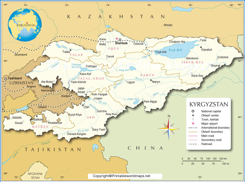
Kyrgyzstan’s administrative structure consists of 7 regions (oblasts) and 2 cities of republican significance: Bishkek and Osh. The seven regions are Batken, Chuy, Jalal-Abad, Issyk-Kul, Naryn, Osh, and Talas.
Therefore, the earlier statement that the country has seven provinces including Bishkek was inaccurate. Bishkek is a city of republican significance, not an oblast. The same applies to Osh.
7 Regions of Kyrgyzstan
| Region | Regional Center |
|---|---|
| Batken Region | Batken |
| Chuy Region | Bishkek* |
| Jalal-Abad Region | Jalal-Abad |
| Issyk-Kul Region | Karakol |
| Naryn Region | Naryn |
| Osh Region | Osh |
| Talas Region | Talas |
Bishkek is the national capital and a separate city of republican significance; it is located in the Chuy Valley but is administratively separate from Chuy Region. Official Kyrgyz sources identify Bishkek as a separate administrative unit.
Labeled Kyrgyzstan Map with Cities
A labeled Kyrgyzstan map with cities helps locate important population centers and regional centers throughout the country.
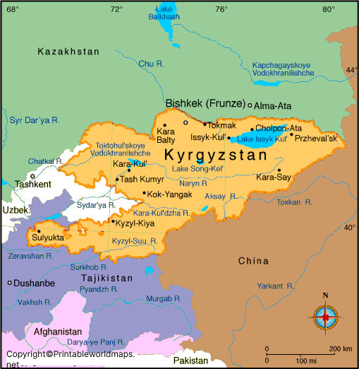
Important cities and settlements shown on maps of Kyrgyzstan include:
- Bishkek
- Osh
- Karakol
- Jalal-Abad
- Naryn
- Talas
- Batken
- Balykchy
- Tokmok
- Kara-Balta
- Kara-Suu
- Uzgen
- Cholpon-Ata
- Tash-Kumyr
- Kyzyl-Kiya
- Talas
City names and administrative classifications can change over time, so maps intended for current reference should be checked against recent official statistical or government information. The Kyrgyz National Statistical Committee maintains current regional and city-level statistical information.
Labeled Kyrgyzstan Map with Capital
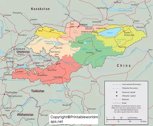
Bishkek is the capital of the Kyrgyz Republic and its largest city. It is located in the northern part of the country in the Chuy Valley, near the Kyrgyz Ala-Too range and close to the Kazakhstan border. The Kyrgyz National Statistical Committee identifies Bishkek as a special administrative unit and a city of republican significance.
The original content stated that Bishkek had about nine million inhabitants. That figure is incorrect for the city and should be removed. Current official sources should be used for population figures instead. The Kyrgyz government’s investment agency, citing the National Statistical Committee’s 2026 statistical handbook, reports Bishkek at approximately 1.4 million people as of January 1, 2026.
Kyrgyzstan Map: Geography and Location
Kyrgyzstan is located in Central Asia and is surrounded by four countries:
- Kazakhstan — north
- Uzbekistan — west
- Tajikistan — south
- China — east
The country is dominated by the Tien Shan mountain system, which explains the extensive mountainous terrain shown on a physical map of Kyrgyzstan. Approximately 94% of the country’s territory is mountainous.
Its geographic position has also made Kyrgyzstan an important part of Central Asian transportation and historical trade routes.
Major Rivers and Lakes in Kyrgyzstan
Water features are an important part of Kyrgyzstan’s geography. Snow and glaciers contribute significantly to the country’s mountain water systems.
The Naryn River is one of the country’s most important rivers and forms part of the Syr Darya river system. Other notable rivers include the Chu (Chuy), Talas, and Kara Darya.
Issyk-Kul, one of the world’s major high-altitude lakes, is another defining geographic feature and is one of the most recognizable features on a physical map of Kyrgyzstan.
For a map-based article, it is better to describe these geographic features rather than use the older claim that Kyrgyzstan has exactly 40,000 rivers and streams unless a current authoritative source is provided.
Kyrgyzstan Map for Students and Teachers
A printable labeled map of Kyrgyzstan can help students learn:
- The capital city
- The seven regions
- Major cities
- Neighboring countries
- Mountainous areas
- Major lakes and rivers
- Central Asian geography
Teachers can use the labeled version as a reference and pair it with a blank map for geography exercises and quizzes.
Interesting Facts About Kyrgyzstan
- Kyrgyzstan is a landlocked country in Central Asia.
- Its official name is the Kyrgyz Republic.
- Bishkek is the national capital.
- Bishkek and Osh are cities of republican significance.
- The country has 7 regions (oblasts).
- About 94% of the country’s territory is mountainous.
- Kyrgyzstan shares international borders with Kazakhstan, Uzbekistan, Tajikistan, and China.
- Osh is one of the country’s major cities and the administrative center of Osh Region.
- The country is strongly associated with the Tien Shan mountain system.
- Issyk-Kul is one of the country’s best-known natural geographic features.
Frequently Asked Questions About the Labeled Map of Kyrgyzstan
What does a labeled map of Kyrgyzstan show?
A labeled map of Kyrgyzstan can show the country’s borders, capital, regions, major cities, rivers, lakes, mountains, and other geographic features.
What is the capital of Kyrgyzstan?
Bishkek is the capital of Kyrgyzstan. It is also the country’s largest city and a city of republican significance.
How many regions does Kyrgyzstan have?
Kyrgyzstan has 7 regions (oblasts): Batken, Chuy, Jalal-Abad, Issyk-Kul, Naryn, Osh, and Talas. Bishkek and Osh are separate cities of republican significance.
What countries border Kyrgyzstan?
Kyrgyzstan borders Kazakhstan, Uzbekistan, Tajikistan, and China.
Is Bishkek part of Chuy Region?
No. Bishkek is administratively separate from Chuy Region and has the status of a city of republican significance. It is located in the Chuy Valley.
What is the second major city of Kyrgyzstan?
Osh is one of Kyrgyzstan’s principal cities and is a city of republican significance. It is also the administrative center of Osh Region.
Can I print the labeled Kyrgyzstan map?
Yes. Printable PDF versions can be provided with the map sections above for educational and reference use.
Why is Kyrgyzstan called a mountainous country?
A large majority of Kyrgyzstan’s territory is mountainous. The country’s geography is dominated by the Tien Shan mountain system, with about 94% of its territory classified as mountainous.
Reference Links
https://www.stat.gov.kg/en/statistics/naselenie
https://stat.gov.kg/en/about/territorialnye-organy
https://www.gov.kg/index.php/en/region/osh
https://www.gov.kg/ru/p/constitution
