
The Labeled Map of Iraq helps identify the country’s governorates, capital, major cities, rivers, and surrounding countries. Iraq is located in Western Asia and forms part of the Middle East. It shares international borders with Turkey to the north, Iran to the east, Kuwait and Saudi Arabia to the south, Jordan to the southwest, and Syria to the west.
Iraq also has a short coastline along the Persian Gulf. Its geography includes the Tigris and Euphrates river systems, extensive plains, desert areas, and mountainous terrain in the north and northeast.
A labeled map is useful for students, teachers, researchers, travelers, and anyone studying the geography of Iraq.
- World map with continents
- Physical world map
- Political world map
- Labeled map of Asia
- Labeled map of Africa
- Labeled map of Europe
- Labeled map of South America
- World time zone map
- Labeled map of world
- Blank map of world
- Labeled map of North America
- Blank map of Asia
- World map with oceans
- World map poster
Labeled Map of Iraq
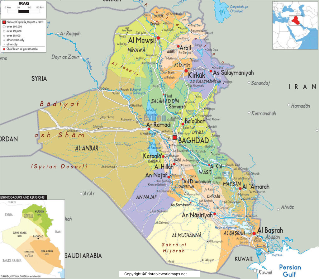
Iraq covers approximately 438,317 square kilometers and has a small coastline on the Persian Gulf. Baghdad is the national capital and one of the country’s most important political, cultural, and economic centers.
The Tigris and Euphrates are Iraq’s two principal rivers. Together, they have played an important role in the development of settlements and agriculture in the region.
For current population information, it is better to use recent United Nations or World Bank datasets rather than older population estimates.
Labeled Map of Iraq with States
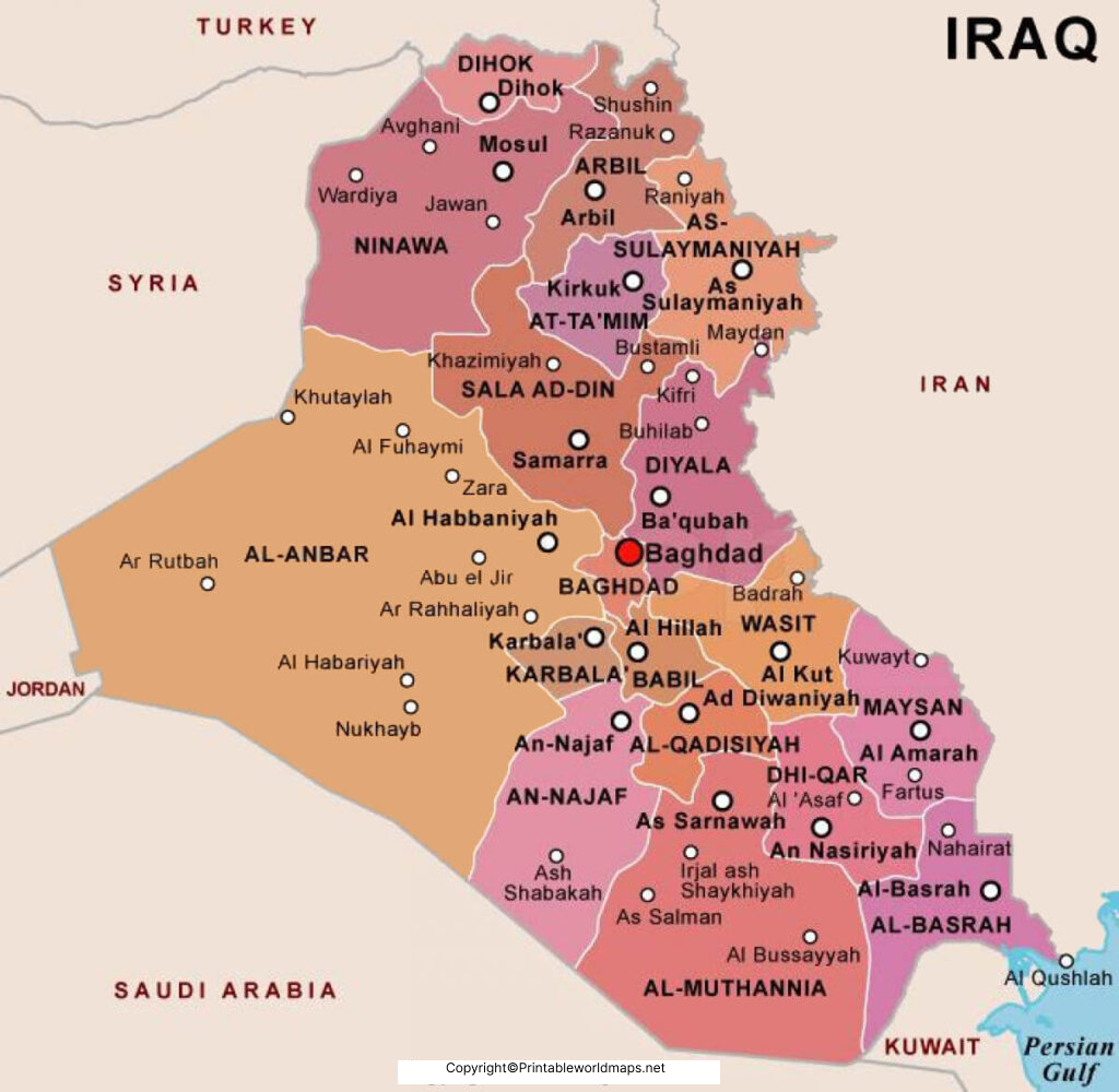
Iraq is administratively divided into governorates, which are sometimes referred to as provinces. The administrative structure has changed over time, so map users should distinguish between the governorates represented on a particular map and later administrative changes.
Major governorates include Baghdad, Basra, Anbar, Erbil, Nineveh, Najaf, Karbala, Kirkuk, Diyala, Dhi Qar, Maysan, Wasit, Babil, Salah al-Din, Sulaymaniyah, Dohuk, Qadisiyah, Muthanna, and Halabja.
Major Governorates of Iraq
| Governorate | Administrative center |
|---|---|
| Baghdad | Baghdad |
| Basra | Basra |
| Anbar | Ramadi |
| Erbil | Erbil |
| Nineveh | Mosul |
| Najaf | Najaf |
| Karbala | Karbala |
| Kirkuk | Kirkuk |
| Diyala | Baqubah |
| Dhi Qar | Nasiriyah |
| Maysan | Amarah |
| Wasit | Kut |
| Babil | Hillah |
| Salah al-Din | Tikrit |
| Sulaymaniyah | Sulaymaniyah |
| Dohuk | Dohuk |
| Qadisiyah | Diwaniyah |
| Muthanna | Samawah |
| Halabja | Halabja |
Labeled Map of Iraq with Cities
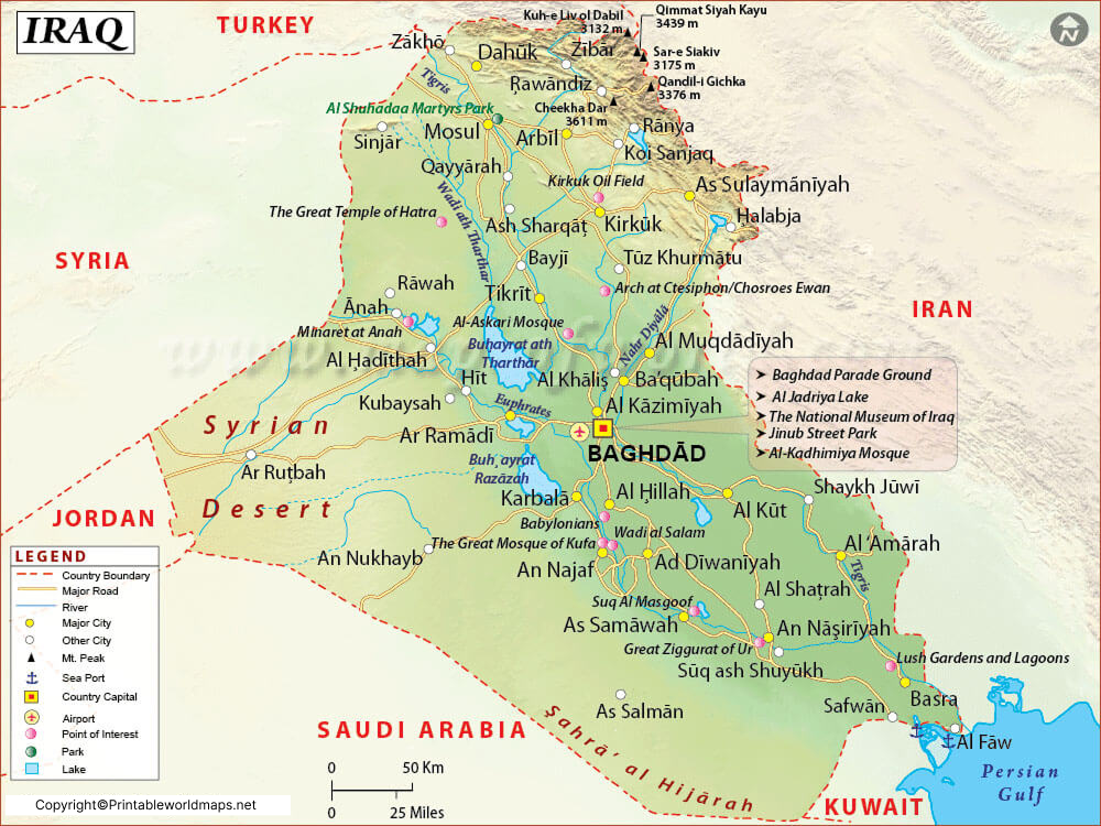
The Labeled Map of Iraq with Cities makes it easier to locate important urban centers across the country. Major cities include Baghdad, Basra, Mosul, Erbil, Kirkuk, Najaf, Karbala, Sulaymaniyah, Nasiriyah, and Hillah.
Baghdad is the country’s capital and largest urban center. Basra is an important southern city and port area, while Mosul is a major city in northern Iraq. Erbil and Sulaymaniyah are important urban centers in the Kurdistan Region.
Major Cities to Locate on an Iraq Map
- Baghdad
- Basra
- Mosul
- Erbil
- Kirkuk
- Najaf
- Karbala
- Sulaymaniyah
- Nasiriyah
- Hillah
Population figures for individual cities can vary depending on the year, census methodology, and whether metropolitan areas or administrative boundaries are being measured. Therefore, older city-population figures should not be presented as current without a source.
Labeled Map of Iraq with Capital
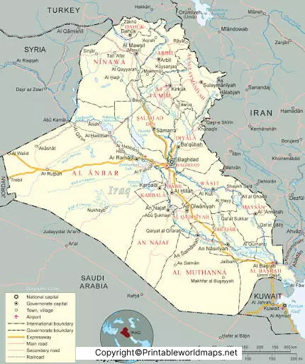
The Labeled Map of Iraq with Capital identifies Baghdad, the capital of Iraq.
Baghdad lies along the Tigris River in central Iraq. The city was founded in the eighth century during the Abbasid period and became an important center of scholarship, culture, administration, and trade.
The Tigris passes through Baghdad, and the city developed on both sides of the river. The historic division between Rusafa on the eastern bank and Karkh on the western bank remains an important geographic reference when studying the city.
Geography of Iraq
Iraq’s geography can be broadly understood through several physical regions:
- Northern and northeastern mountains: Higher elevations occur toward the borders with Turkey and Iran.
- Mesopotamian plain: The Tigris and Euphrates river systems shape much of central and southern Iraq.
- Western desert: Large arid areas extend across western Iraq.
- Southern wetlands: The Mesopotamian Marshes are an important wetland ecosystem in southern Iraq.
- Persian Gulf coastline: Iraq has a relatively short coastline in the southeast.
The Tigris and Euphrates have historically supported agriculture and settlements and are central to understanding Iraq’s geography.
Major Rivers Shown on a Map of Iraq
The two principal rivers are:
Tigris River: Flows through northern and central Iraq, including Baghdad, before continuing toward the Shatt al-Arab.
Euphrates River: Crosses western and central parts of Iraq before joining the Tigris system in the south.
Other important waterways and tributaries include the Diyala, Great Zab, and Little Zab.
Why Use a Labeled Map of Iraq?
A Labeled Map of Iraq can be useful for:
- Geography assignments
- School and college projects
- Learning Iraqi governorates
- Locating major Iraqi cities
- Understanding Iraq’s neighboring countries
- Studying the Tigris and Euphrates
- Planning geography lessons
- Printing classroom reference material
- Comparing political and physical geography
The downloadable PDF versions are particularly useful when a printable reference is needed.
Interesting Facts About Iraq
- Baghdad is the capital of Iraq.
- Iraq is located in Western Asia.
- The country has borders with six countries: Turkey, Iran, Kuwait, Saudi Arabia, Jordan, and Syria.
- Iraq has a short coastline along the Persian Gulf.
- The Tigris and Euphrates are the country’s two major rivers.
- Ancient Mesopotamia developed around the Tigris and Euphrates river systems.
- The Mesopotamian Marshes are located in southern Iraq and form an important wetland landscape.
Frequently Asked Questions
What is the capital of Iraq?
Baghdad is the capital of Iraq. It is located on the Tigris River in central Iraq.
How many governorates does Iraq have?
Iraq’s administrative structure includes 19 governorates when Halabja is included. Administrative classifications can change, so official Iraqi government sources should be checked for the latest status.
What are the major cities in Iraq?
Major Iraqi cities include Baghdad, Basra, Mosul, Erbil, Kirkuk, Najaf, Karbala, and Sulaymaniyah.
Which countries border Iraq?
Iraq shares land borders with Turkey, Iran, Kuwait, Saudi Arabia, Jordan, and Syria.
What are the major rivers in Iraq?
The Tigris and Euphrates are Iraq’s principal rivers. The country also has several tributaries and other waterways.
What is the largest city in Iraq?
Baghdad is Iraq’s largest urban center and its capital.
Baghdad is Iraq’s largest urban center and its capital.
Iraq is located in Western Asia, within the Middle East. It lies between Iran, Turkey, Syria, Jordan, Saudi Arabia, and Kuwait.
Can I download a printable Iraq map?
Yes. The map images and PDF files on this page can be used as printable geographic references, subject to the site’s usage terms.
Reference Links
https://www.cia.gov/the-world-factbook/countries/iraq
https://data.worldbank.org/country/iraq
https://data.un.org/en/iso/iq.html









