

A Labeled Map of Kuwait helps you identify the country’s six governorates, capital city, major urban areas, islands, and neighboring countries. Kuwait is located in Western Asia at the northwestern end of the Arabian Gulf, between Iraq and Saudi Arabia. Its location, administrative divisions, and coastal geography make it an interesting country to explore on a political or reference map.
This guide includes labeled maps of Kuwait, maps showing its governorates and cities, a capital map, and printable PDF resources for students, teachers, travelers, and geography enthusiasts.
- World map with continents
- Physical world map
- Political world map
- Labeled map of Asia
- Labeled map of Africa
- Labeled map of Europe
- Labeled map of South America
- World time zone map
- Labeled map of world
- Blank map of world
- Labeled map of North America
- Blank map of Asia
- World map with oceans
- World map poster
Labeled Map of Kuwait
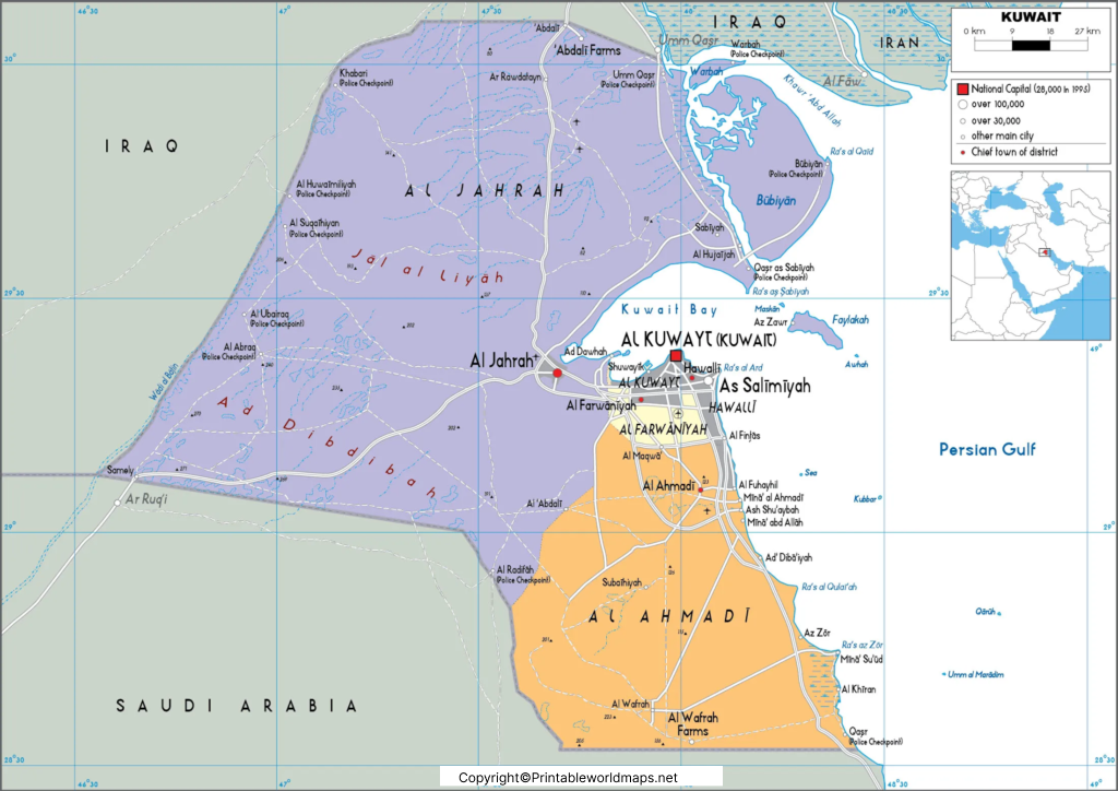
A labeled map makes it easier to understand Kuwait’s position on the Arabian Peninsula and the distribution of its cities and coastal areas. Depending on the map’s labels, you can use it to locate Kuwait City, surrounding urban communities, neighboring countries, and important islands.
Kuwait has a total area of approximately 17,818 square kilometers. Its landscape is predominantly flat and arid, with desert terrain and a coastline along the Arabian Gulf. The country has no permanent rivers, making its physical geography quite different from that of countries with extensive river systems.
Kuwait’s official language is Arabic, and its currency is the Kuwaiti dinar (KWD). Kuwait City is the national capital and the country’s principal urban center.
Labeled Kuwait Map with States
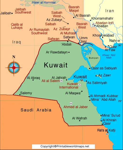
Kuwait is administratively divided into six governorates, locally known as muhafazat. Although they may sometimes be described as states or provinces in informal map searches, governorates is the correct administrative term.
The six governorates of Kuwait are:
- Capital Governorate (Al Asimah): Includes Kuwait City and important government, commercial, and cultural institutions.
- Hawalli Governorate: A densely populated urban area with residential and commercial districts.
- Al Ahmadi Governorate: Located south of the capital and associated with important oil and industrial activities.
- Al Farwaniyah Governorate: A major population center that includes the area around Kuwait International Airport.
- Al Jahra Governorate: The country’s largest governorate by area, with desert landscapes and agricultural areas.
- Mubarak Al-Kabeer Governorate: A governorate in the southern part of the metropolitan region, named after Sheikh Mubarak Al-Sabah.
These administrative divisions help organize local government and public services. A labeled governorate map is useful for understanding their relative locations and for distinguishing administrative boundaries from individual cities and neighborhoods.
Labeled Map of Kuwait with Cities
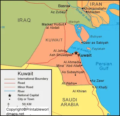
Kuwait contains several important cities, towns, and urban districts. Their locations help explain how residential communities, commercial centers, industrial areas, and transport facilities are distributed throughout the country.
Major places to identify on a labeled Kuwait city map include:
- Kuwait City: The national capital and a major commercial, cultural, and administrative center.
- Hawalli: A prominent urban area east of the capital.
- Salmiya: A coastal urban district known for residential and commercial development.
- Farwaniya: A major urban area in the country’s metropolitan region.
- Jahra: An important urban center to the west of Kuwait City.
- Ahmadi: A city associated with Kuwait’s oil industry.
- Fahaheel: A coastal urban area in the south.
- Mangaf and Mahboula: Residential and commercial communities south of the capital.
- Sabah Al Ahmad: A planned urban development in southern Kuwait.
Place names and boundaries may appear differently across maps because some sources identify municipalities, some show cities, and others label neighborhoods or urban districts. Check the map legend to understand what each label represents.
Labeled Kuwait Map with Capital
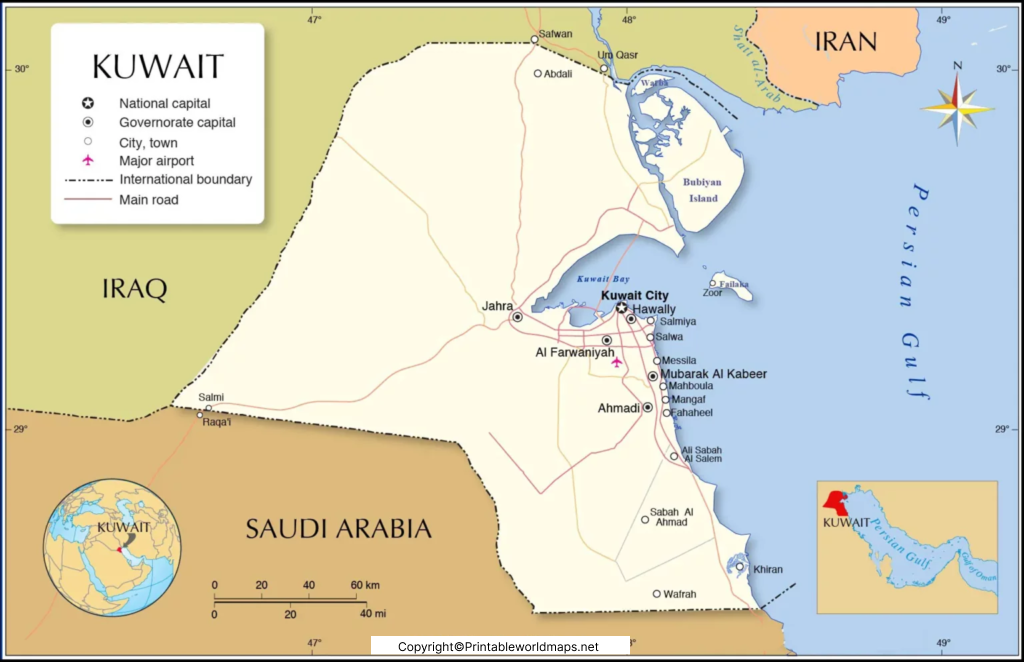
Kuwait City is the capital of the State of Kuwait. It is situated on the southern shore of Kuwait Bay, along the Arabian Gulf. The city is the country’s principal center for national administration, business, finance, culture, and many public institutions.
Kuwait City and its surrounding metropolitan areas form a major concentration of residential and commercial activity. The wider urban region includes communities such as Hawalli and Salmiya, while industrial and oil-related centers extend farther south.
The capital map is especially useful for identifying Kuwait City in relation to the coastline, neighboring districts, and the country’s wider road network. For accurate navigation, use an up-to-date road map or official mapping service in addition to a general geographic map.
University of Kuwait
Kuwait University is a public university established in 1966. It is an important institution in the country’s higher education system. Its campuses and facilities are spread across different locations, so a current university source should be consulted for specific campus addresses and directions.
Geography and Location of Kuwait
Kuwait lies in Western Asia at the northeastern end of the Arabian Peninsula. Iraq borders Kuwait to the north and west, Saudi Arabia borders it to the south, and the Arabian Gulf lies to the east.
The country’s geographic position has supported its role in maritime trade and the petroleum industry. Kuwait’s coastline and nearby islands are also important features to look for on a physical or political map.
Key geographic facts include:
- Official name: State of Kuwait
- Capital: Kuwait City
- Region: Western Asia
- Total area: Approximately 17,818 square kilometers
- Official language: Arabic
- Currency: Kuwaiti dinar (KWD)
- Time zone: Arabia Standard Time (UTC+3)
- Land borders: Iraq and Saudi Arabia
- Landscape: Predominantly arid desert terrain
For current population figures, use the Kuwait Central Statistical Bureau or the United Nations data portal. Population estimates vary by reference year and methodology, so a dated official figure is more reliable than an undated number copied from older map content.
Islands of Kuwait
Kuwait includes several islands in the Arabian Gulf. Some are important geographic landmarks, while others are notable for their ecological, historical, or strategic significance.
- Bubiyan Island: The largest island belonging to Kuwait, located in the northern part of the Gulf near the Iraqi border.
- Failaka Island: Known for its archaeological remains and historical connections with ancient settlements and maritime activity.
- Miskan Island: A small island off Kuwait’s coast.
- Auhah Island: One of Kuwait’s smaller offshore islands.
- Umm Al-Namil Island: Noted for archaeological sites.
- Kubbar, Qaruh, and Umm Al-Maradim: Smaller islands in the Gulf.
- The number of islands mentioned in reference materials can vary according to how individual islets and geographic features are counted. Consult official Kuwait sources for authoritative island information.
Why Use a Labeled Map of Kuwait?
A labeled map can support several practical learning and reference tasks:
- Geography education: Learn Kuwait’s location and neighboring countries.
- Administrative studies: Identify all six governorates and their relative positions.
- City identification: Locate major urban centers and distinguish them from governorates.
- Travel planning: Understand the broad geographic relationship between the capital, coastal districts, and southern communities.
- Printable classroom activities: Use the map as a visual reference for lessons and geography exercises.
- Research and presentations: Add a geographic overview to school assignments, reports, and presentations.
For the best results, select a map that clearly distinguishes country boundaries, governorate boundaries, cities, and physical features.
Printable Kuwait Map: PNG and PDF
The maps included in this article are available as image files and PDF documents where provided. PNG images are convenient for viewing on screens and inserting into presentations. PDFs are often more convenient for printing because they can preserve the document’s page layout.
Before printing, check the PDF page size, map labels, and image resolution. A map designed for a screen may need a larger paper size to keep smaller place names readable. For school activities, consider pairing a labeled map with a blank map so learners can practice identifying governorates and cities independently.
Frequently Asked Questions About the Labeled Map of Kuwait
1. What is the capital of Kuwait?
Kuwait City is the capital of the State of Kuwait. It is located on the southern shore of Kuwait Bay along the Arabian Gulf.
2. How many governorates does Kuwait have?
Kuwait has six governorates: Capital, Hawalli, Al Ahmadi, Al Farwaniyah, Al Jahra, and Mubarak Al-Kabeer.
3. What countries border Kuwait?
Kuwait shares land borders with Iraq to the north and west and Saudi Arabia to the south. The Arabian Gulf lies to the east.
4. What is the total area of Kuwait?
Kuwait covers approximately 17,818 square kilometers, according to official and international geographic references.
5. Which are the major cities and urban areas in Kuwait?
Important urban centers and districts include Kuwait City, Hawalli, Salmiya, Farwaniya, Jahra, Ahmadi, Fahaheel, Mangaf, and Mahboula. Their administrative classification can vary by source.
6. What is the largest island in Kuwait?
Bubiyan Island is the largest island belonging to Kuwait.
7. Can I download a printable map of Kuwait?
Yes. This article provides links to Kuwait map images and PDF files. Open the relevant PDF link and use your browser’s download or print function if the file is accessible.
8. What is the difference between a Kuwait governorate map and a city map?
A governorate map shows Kuwait’s six major administrative divisions. A city map focuses on individual cities, towns, and urban districts. The two map types serve different purposes and should not be treated as interchangeable.
Reference links
https://www.e.gov.kw/sites/kgoenglish/Pages/Visitors/AboutKuwait/KuwaitAtaGlaneTopography.aspx
https://e.gov.kw/sites/kgoenglish/Pages/Visitors/AboutKuwait/KuwaitAtaGlaneGeographicalLocation.aspx
