

Looking for a Europe map with countries that you can download and print? Explore our collection of free printable political maps of Europe, including maps with country names, national capitals, major cities, and European Union member states. These maps are useful for students, teachers, geography enthusiasts, and anyone who wants to understand Europe’s political geography.
Choose the map that best suits your needs and download the available PDF for printing or classroom activities. You can also explore our blank map of Europe, labeled map of Europe, and other free continent maps.
Europe Political Map
A political map of Europe shows countries, international boundaries, and, depending on the map, capital cities and major urban areas. It is useful for learning country locations, comparing national borders, and identifying the regions surrounding the continent.
Europe and the European Union (EU) are not the same. Europe is a geographical continent, while the EU is a political and economic union with 27 member countries. Several European countries, including the United Kingdom, Norway, and Switzerland, are not EU members.
Geographical conventions also affect how Europe is represented. Russia spans Europe and Asia, and Türkiye (Turkey) has territory on both continents. The exact countries shown on a map can therefore depend on the geographic definition and the map’s intended purpose.

This map identifies European countries and selected capitals and major cities. Use it to study political boundaries and the location of important urban centres.
Map of Europe with Countries
This printable Europe map with countries focuses on country names and political divisions. It is a useful option for general geography study, school assignments, revision, and map-based learning activities.
Unlike a map that includes numerous city labels, a country-focused map can make national boundaries easier to see. Before printing, check the map’s labels and page layout to ensure that smaller countries and their names remain readable.
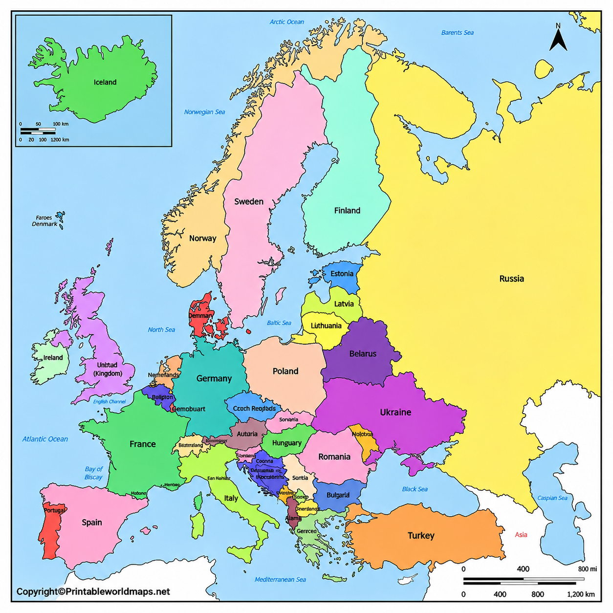
The map also identifies surrounding seas and ocean areas. For more detailed information about mountains, plains, rivers, and other natural features, visit our physical map of Europe.
How to Use a Printable Europe Map
- Students: Practise identifying countries and locating them in relation to neighbouring states.
- Teachers: Use printed maps for classroom quizzes, geography lessons, and group activities.
- Travellers: Get a broad overview of countries and their relative locations before planning a trip.
- Geography enthusiasts: Compare national boundaries and learn how Europe’s political geography differs from its physical geography.
For the best results, choose a larger page format when a map contains many country names or capital labels.
Cold War Map of Europe Political
Europe’s political map changed considerably during the twentieth century. A historical political map helps explain how borders and countries evolved during and after the Cold War.
Germany was divided into the Federal Republic of Germany (West Germany) and the German Democratic Republic (East Germany) from 1949 until reunification in 1990. The Berlin Wall fell in November 1989, marking a major turning point in the end of the Cold War in Europe.

The Soviet Union dissolved in 1991, and Czechoslovakia separated peacefully into the Czech Republic and Slovakia in 1993. Yugoslavia also broke apart through a complex series of political changes and conflicts that resulted in several independent states.
Northern, Southern, Eastern, and Western Europe
Europe is commonly divided into geographical subregions for statistical, educational, and analytical purposes. The precise country groupings can vary between organisations and reference systems.
The United Nations Statistics Division uses the M49 geographic classification. Its groupings are intended for statistical purposes and should not be treated as a universal definition of regional identity.
- Northern Europe: Includes countries such as Denmark, Finland, Iceland, Norway, Sweden, Estonia, Latvia, and Lithuania, along with the United Kingdom and Ireland in the UN classification.
- Western Europe: Includes countries such as France, Germany, Belgium, the Netherlands, Austria, Switzerland, and Luxembourg.
- Eastern Europe: Includes countries such as Poland, Czechia, Slovakia, Hungary, Romania, Bulgaria, Belarus, Ukraine, and the Russian Federation in the UN classification.
- Southern Europe: Includes countries such as Italy, Spain, Portugal, Greece, Croatia, Serbia, Albania, and other countries in the southern part of the continent.
Central Europe is also a widely used regional term, although its boundaries vary depending on historical, cultural, and geographical context.
Political Map of Europe with Capitals
A Europe map with capitals helps readers connect each country with its seat of government. It is particularly useful for school geography, quizzes, travel preparation, and learning European political geography.
Some maps also include major cities, which can help distinguish a country’s capital from other important urban centres. For example, Amsterdam is the constitutional capital of the Netherlands, while The Hague is the seat of government.
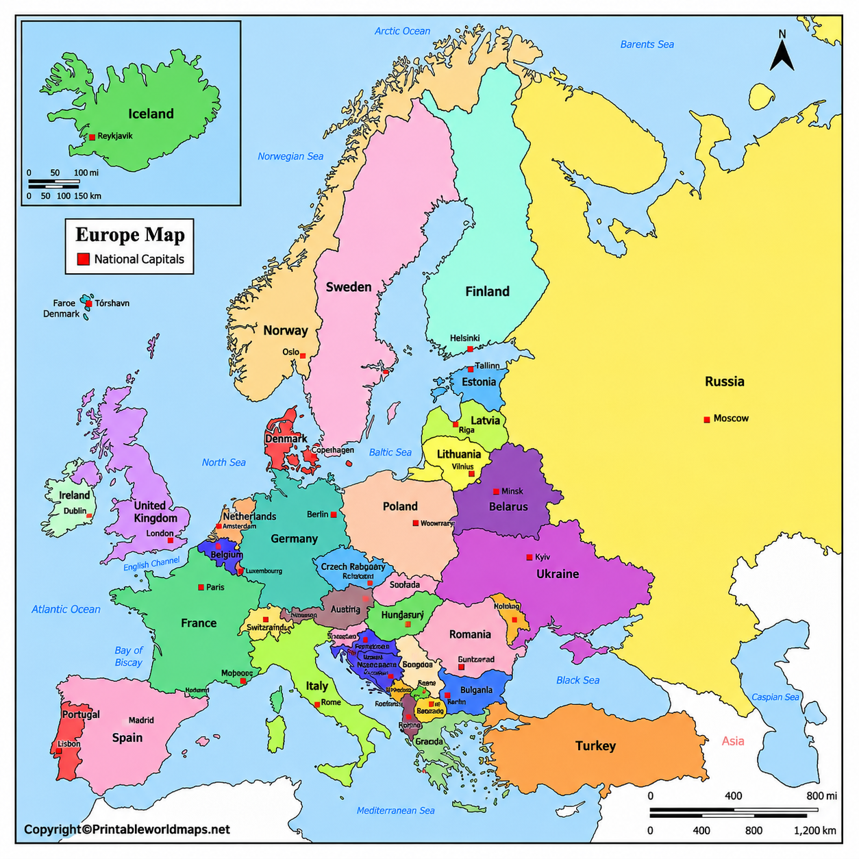
For additional learning materials, visit our labeled map of Europe and blank map of Europe.
Printable Europe Political Map of the European Union
A political map of the European Union highlights the countries that belong to this political and economic union. It should not be confused with a map of the entire European continent.
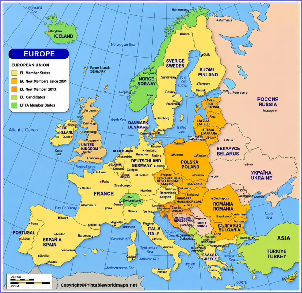
The European Union currently has 27 member countries. Its modern institutional history includes the European Economic Community, established by the Treaty of Rome in 1957 by Belgium, France, Italy, Luxembourg, the Netherlands, and West Germany. The United Kingdom left the EU on 31 January 2020.
Ukraine became an EU candidate country in June 2022. Candidate status does not mean that a country is already an EU member.
Europe Political Map Labeled
A labeled political map of Europe makes it easier to identify countries and understand their positions relative to neighbouring countries, coastlines, and seas.
Europe is bordered by the Atlantic Ocean to the west, the Arctic Ocean to the north, and the Mediterranean and Black seas to the south and southeast. The conventional boundary between Europe and Asia passes through areas that include the Ural Mountains and the Caucasus region, although geographic definitions can differ.
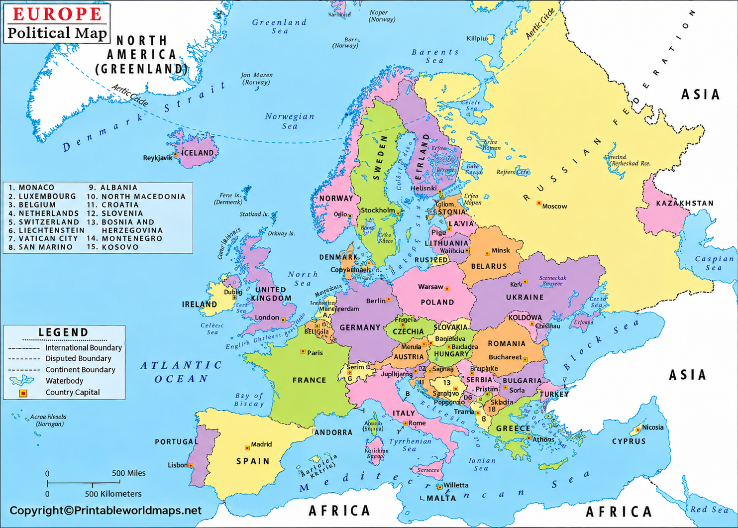
Istanbul is a major city spanning the European and Asian sides of the Bosporus. Moscow is the capital of Russia, while Kyiv is the capital of Ukraine.
European Countries and Their Capitals
The table below provides a practical reference to commonly recognised European sovereign states and their capitals. Lists of European countries can differ according to geographic scope and political recognition, particularly for transcontinental countries and Kosovo.
| Country | Capital |
|---|---|
| Albania | Tirana |
| Andorra | Andorra la Vella |
| Austria | Vienna |
| Belarus | Minsk |
| Belgium | Brussels |
| Bosnia and Herzegovina | Sarajevo |
| Bulgaria | Sofia |
| Croatia | Zagreb |
| Cyprus | Nicosia |
| Czechia | Prague |
| Denmark | Copenhagen |
| Estonia | Tallinn |
| Finland | Helsinki |
| France | Paris |
| Germany | Berlin |
| Greece | Athens |
| Hungary | Budapest |
| Iceland | Reykjavík |
| Ireland | Dublin |
| Italy | Rome |
| Kosovo | Pristina |
| Latvia | Riga |
| Liechtenstein | Vaduz |
| Lithuania | Vilnius |
| Luxembourg | Luxembourg |
| Malta | Valletta |
| Moldova | Chișinău |
| Monaco | Monaco |
| Montenegro | Podgorica |
| Netherlands | Amsterdam |
| North Macedonia | Skopje |
| Norway | Oslo |
| Poland | Warsaw |
| Portugal | Lisbon |
| Romania | Bucharest |
| Russia | Moscow |
| San Marino | San Marino |
| Serbia | Belgrade |
| Slovakia | Bratislava |
| Slovenia | Ljubljana |
| Spain | Madrid |
| Sweden | Stockholm |
| Switzerland | Bern |
| Türkiye (Turkey) | Ankara |
| Ukraine | Kyiv |
| United Kingdom | London |
| Vatican City | Vatican City |
The United Kingdom’s constituent countries—England, Scotland, Wales, and Northern Ireland—are not four separate sovereign states. For this reason, the table lists the United Kingdom as one country rather than listing its constituent countries separately.
Tips for Printing a Europe Map PDF
- Select the PDF version that best matches your purpose, whether it shows countries only, capitals, or the European Union.
- Use A4 paper for most school assignments and everyday printing. A5 can be convenient for compact handouts, but labels may be smaller.
- Select “Fit to printable area” in your printer settings if the map is cropped at the edges.
- Use colour printing when political regions are distinguished by colour. For black-and-white printing, confirm that country boundaries and labels remain visible.
- Check the map’s publication date and geographic conventions before using it for formal educational or reference purposes.
Frequently Asked Questions
1. Where can I download a Europe map with countries for free?
You can download the printable PDF maps linked on this page. Choose a country-labeled map, a political map with capitals, or the European Union map according to your requirements.
2. How many countries are in Europe?
There is no single universally agreed count because definitions differ for transcontinental countries and territories with disputed or partially recognised status. Many general references count approximately 44 to 50 countries, depending on their criteria. Always check the definition used by your source.
3. Is Europe the same as the European Union?
No. Europe is a continent, while the European Union is a political and economic union consisting of 27 member countries. Not every European country belongs to the EU.
4. Can I print these Europe maps for school projects?
Yes, the linked PDFs are suitable for personal study and classroom activities. Check the website’s usage terms before reproducing or distributing maps commercially.
5. What is the difference between a political map and a physical map of Europe?
A political map focuses on countries, borders, and sometimes capitals. A physical map shows natural features such as mountains, rivers, plains, and elevations.
6. Which Europe map is best for learning capitals?
Choose a labeled political map that clearly identifies both countries and capital cities. If the labels are too crowded, use a larger printable format.
7. Why do some Europe maps include Russia and Türkiye?
Both countries have territory in Europe and Asia. Map publishers may include all of either country or only the territory conventionally considered European, depending on the map’s purpose.
8. What is the best paper size for a printable Europe map?
A4 is a good general-purpose option. A5 is useful for smaller handouts, while larger formats may improve readability when a map contains many labels.
Reference links
https://unstats.un.org/unsd/methodology/m49
https://european-union.europa.eu/principles-countries-history/country-profiles_en
https://www.coe.int/en/web/about-us/our-member-states
https://printableworldmaps.net/wp-content/uploads/2025/05/EUROPE-political-maps.jpg-797×1024-1.pdf
https://printableworldmaps.net/wp-content/uploads/2023/07/Europe-Map-with-Countries-A4.pdf
https://printableworldmaps.net/wp-content/uploads/2023/07/Europe-Map-with-Countries-A5.pdf
https://printableworldmaps.net/wp-content/uploads/2025/05/EUROPE-political-map.jpg-802×1024-1.pdf
https://printableworldmaps.net/wp-content/uploads/2023/07/Europe-Map-with-Capitals-A4.pdf
https://printableworldmaps.net/wp-content/uploads/2023/07/Europe-Map-with-Capitals-A5.pdf
https://printableworldmaps.net/wp-content/uploads/2023/07/EUROPE-map-political.pdf
https://printableworldmaps.net/wp-content/uploads/2023/07/map-of-EUROPE-political.pdf
More Free Maps to Download and Print
Have you found the political Europe map you were looking for? If not, maybe you will find a convenient map of Europe or any other map you might need via the link selection below. You can also use our search bar at the top of the page to find more maps of the world, its continents and many countries.
We offer physical, blank and political maps but also river and mountain maps of different regions of the world. You can download them all as PDF files and print them out as often as you like.
Other Maps of Europe
European Country Maps
Map of Germany with States and Cities
Map of Sweden with States and Cities
Other Country Maps
US State Maps
Continent Maps
Labeled Map of Africa with Countries


