

Looking for a labeled map of Sweden to learn about its cities, capital, and geographical divisions? This page provides printable Sweden maps with labels, including maps showing major cities, administrative counties, and capital locations. You can view the maps online or download the available PDF versions for educational and personal use.
Sweden is a Nordic country in Northern Europe. It shares land borders with Norway to the west and Finland to the northeast, while Denmark lies to the southwest across the Öresund Strait. Stockholm is the capital of Sweden and one of the country’s most important urban centres.
Sweden is divided into 21 counties and 290 municipalities. These administrative divisions are useful for understanding regional boundaries, while the country’s 25 traditional provinces represent historical and cultural regions. The maps below help students, teachers, travellers, and geography enthusiasts explore Sweden more easily.
- World coronavirus map
- World geographical map
- World map for kids
- World population map
- Accurate map of World
- Ancient World map
- World Map Wallpaper
Labeled Map of Sweden
A labeled map of Sweden identifies the country’s location, major geographical features, and other details according to the information included on the map. It is a useful starting point for learning about Sweden’s overall shape, neighbouring countries, and important locations.

Use this map for geography lessons, classroom activities, country identification, and general reference. Check the labels and legend on the map to understand exactly which geographical features are shown.
Labeled Map of Sweden with States(Counties)
Sweden does not have states in the same administrative sense as countries such as the United States. Instead, its main regional administrative divisions are called counties, known in Swedish as län.
There are 21 counties in Sweden, including Stockholm County, Skåne County, Västra Götaland County, and Uppsala County. These divisions help organise regional administration and provide a practical way to study the country’s geography.
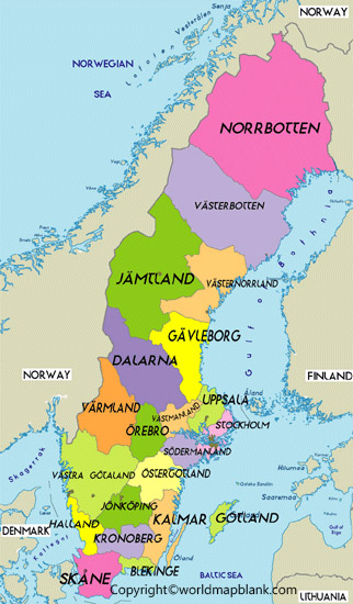
This map can help learners compare regional boundaries and identify the counties shown. For the most accurate information about current administrative divisions, consult Statistics Sweden’s official county and municipality information.
Remember that Sweden’s 25 traditional provinces are different from its 21 administrative counties. Provinces are mainly historical and cultural regions, so a province map and a county map serve different purposes.
Sweden Map with Cities Labeled
A Sweden map with cities labeled helps readers locate major urban centres and understand their geographical distribution. Sweden’s cities and towns extend from the southern region around Malmö to central Sweden and the far north around Kiruna.
Some well-known Swedish cities include Stockholm, Gothenburg (Göteborg), Malmö, Uppsala, Västerås, Örebro, Linköping, Umeå, and Kiruna. Their locations make it easier to understand the country’s north–south extent and the relationship between its major population centres.

Use this map to practise locating cities, plan geography exercises, or gain a general understanding of Sweden’s urban geography. The exact cities included depend on the map’s labels, so check the image before using it for a specific assignment.
For current geographical and statistical information, visit Statistics Sweden.
Labeled Sweden Map with Capitals
Stockholm is the national capital of Sweden. It is situated in the eastern part of the country, near the Baltic Sea, and is built across several islands and connected waterways.
A map highlighting Sweden’s capital can help learners distinguish the national capital from other important cities. It is also useful for understanding Stockholm’s position relative to Gothenburg in the southwest and Malmö in the south.

Use the map for school projects, capital-city identification, and general geography study. If you need the administrative centres of all 21 counties rather than the national capital alone, use an appropriate county reference map and verify the names against official sources.
Geography of Sweden: Important Facts
The following facts provide additional context for readers using a labeled map of Sweden.
- Capital: Stockholm.
- Region: Northern Europe; part of the Nordic region.
- Land borders: Norway and Finland.
- Administrative divisions: 21 counties and 290 municipalities.
- Traditional provinces: 25 historical and cultural provinces.
- Major cities: Stockholm, Gothenburg, Malmö, Uppsala, Västerås, Örebro, Linköping, Umeå, and Kiruna.
- Important bodies of water: The Baltic Sea, Gulf of Bothnia, Lake Vänern, and Lake Vättern.
- Geographical character: Sweden stretches a considerable distance from north to south and includes forests, lakes, coastal areas, islands, and mountainous terrain in the northwest.
These facts can help readers interpret the maps and understand why Sweden’s regional geography varies between the south, central areas, and the north.
How to Use and Print a Sweden Map
Follow these simple steps to use the maps on this page:
- Choose the map that best matches your needs, such as a general labeled map, a city map, or a county map.
- Open the image to inspect its labels and geographical details.
- Select the corresponding PDF link when a printable version is available.
- Print the PDF using the page size and orientation that best fit the map.
- For schoolwork or research, cross-check administrative names and boundaries against official Swedish sources.
For the clearest printed results, choose a high-resolution file and review the print preview before printing. A map designed for general learning may not include every municipality, road, or settlement.
Frequently Asked Questions About the Labeled Map of Sweden
What is the capital of Sweden?
Stockholm is the capital of Sweden. It is located in the eastern part of the country and is an important centre for government, business, culture, and transport.
How many states does Sweden have?
Sweden does not use states as its main administrative divisions. It has 21 counties and 290 municipalities. The term “states” in the title is retained for search continuity, but “counties” is the more accurate term for the administrative map.
How many provinces does Sweden have?
Sweden has 25 traditional provinces, known as landskap. They are historical and cultural regions rather than the country’s current main administrative divisions.
Which are the major cities in Sweden?
Stockholm, Gothenburg, Malmö, Uppsala, Västerås, Örebro, Linköping, Umeå, and Kiruna are among Sweden’s well-known cities. The cities displayed on a particular map depend on its level of detail.
Can I download a labeled map of Sweden in PDF format?
Yes. PDF links are provided alongside the maps where available. Open the relevant PDF link to view or download the printable file.
Which map of Sweden is best for students?
A general labeled map is a good starting point for learning the country’s location and geographical features. A city map is useful for identifying urban centres, while a county map is more suitable for studying administrative divisions.
Where can I verify Sweden’s county boundaries?
Statistics Sweden provides official information about the country’s counties and municipalities. Consult its county and municipality reference page to verify administrative divisions.
Reference links
https://www.government.se/how-sweden-is-governed/the-swedish-model-of-government-administration

3 thoughts on “Labeled Map of Sweden with States, Cities & Capital”