
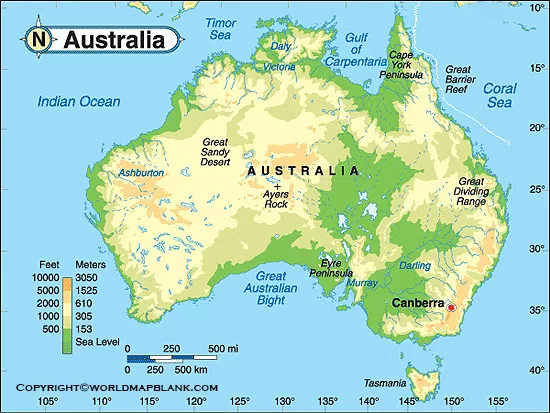
Explore the Australia Physical Map to understand the continent’s major landforms, elevation patterns, deserts, mountain ranges, rivers, plains, and surrounding seas. These printable physical maps are useful for geography students, teachers, researchers, and anyone learning about Australia’s physical geography.
Australia is both a country and a continent. Its physical geography is characterized by a relatively flat interior, extensive deserts, a mountain system along the eastern side, and long coastal areas. Tasmania and numerous smaller islands are also part of Australia.
Australia Physical Map
Australia is located in Oceania, between the Indian Ocean and the Pacific Ocean. It is the world’s smallest continent by land area and is also one of the world’s most geographically diverse regions.
The Australia Physical Map helps identify major physical features such as mountain ranges, deserts, rivers, plains, plateaus, and coastal areas.
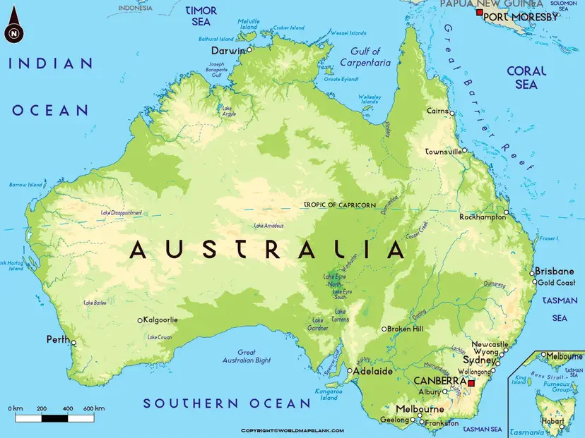
Australia’s mainland covers about 7.69 million square kilometres, making it the sixth-largest country in the world by area. Its interior contains large arid and semi-arid regions, while more populated areas are concentrated mainly along the eastern, southeastern, and southwestern coasts.
Major Physical Features of Australia
Some of the important physical features shown or associated with an Australia physical map include:
- Great Dividing Range – Australia’s major mountain system, extending along much of the eastern part of the country.
- Australian Alps – The highest mountain region in Australia, located within the Great Dividing Range.
- Mount Kosciuszko – Australia’s highest mainland mountain at 2,228 metres above sea level.
- Western Plateau – A vast elevated region covering much of western Australia.
- Central Lowlands – A broad low-lying region between the Western Plateau and the Great Dividing Range.
- Great Artesian Basin – One of the world’s largest groundwater basins.
- Great Barrier Reef – A vast coral reef system off Queensland’s northeastern coast.
- Nullarbor Plain – A large, predominantly treeless plain extending across southern Australia.
- Murray-Darling Basin – Australia’s largest major river basin and an important agricultural region.
Printable Australia Physical Map
The Printable Australia Physical Map is useful for classroom activities, geography assignments, map labeling, revision, and general reference.
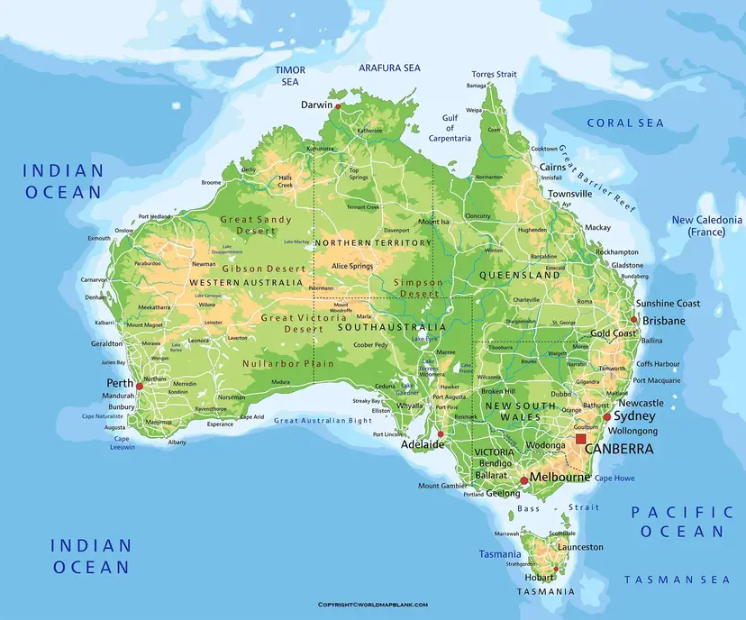
A physical map focuses on Australia’s natural landscape rather than political boundaries. Depending on the map, colors and shading can indicate elevation, terrain, and major geographical regions.
Major Australian cities such as Sydney, Melbourne, Brisbane, Perth, Adelaide, Darwin, Hobart, and Canberra can be used as geographic reference points when studying the relationship between Australia’s population centers and its physical landscape.
The Arafura Sea lies north of Australia, while the Timor Sea is located between northern Australia and Timor. The Coral Sea lies off Australia’s northeastern coast, and the Tasman Sea separates mainland Australia from New Zealand.
Map of Australia Physical
The Map of Australia Physical provides a visual overview of the continent’s natural geography. It can help users identify the relationship between Australia’s mountain systems, plateaus, lowlands, deserts, rivers, and coastal regions.
Australia’s landscape is commonly described through three broad physical divisions:
- Western Plateau – Covers much of western Australia and contains extensive deserts and ancient geological landscapes.
- Central Lowlands – Includes major drainage areas and low-lying plains across central Australia.
- Eastern Highlands – Includes the Great Dividing Range and Australia’s highest mountain areas.
- These divisions make a physical map particularly useful for understanding Australia’s overall terrain and elevation.
Map of Australia Physical Labeled
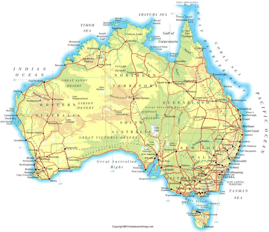
The Map of Australia Physical Labeled provides a clearer reference for identifying physical geographic features.
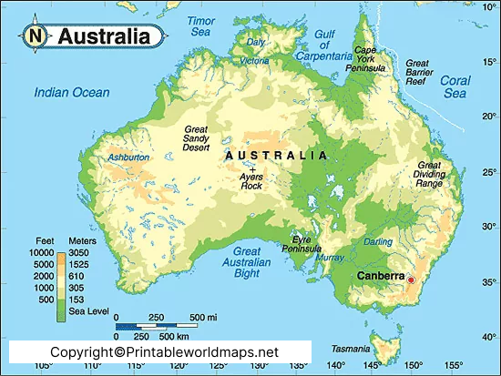
The labeled map can be useful for students studying Australian geography because important landforms and geographic regions can be identified directly on the map. It can also be printed for classroom exercises, geography projects, and revision.
Important Landforms to Locate on an Australia Physical Map
When studying an Australia physical map, look for these major features:
| Physical Feature | Location / Significance |
|---|---|
| Great Dividing Range | Eastern Australia; Australia’s major mountain system |
| Australian Alps | Southeastern Australia; Australia’s highest mountain region |
| Mount Kosciuszko | New South Wales; 2,228 m high |
| Western Plateau | Covers much of western Australia |
| Great Victoria Desert | Western and southern interior |
| Great Sandy Desert | Northwestern Australia |
| Gibson Desert | Central-western Australia |
| Simpson Desert | Central Australia |
| Nullarbor Plain | Southern Australia |
| Murray River | Major river of southeastern Australia |
| Darling River | Major river within the Murray-Darling system |
| Lake Eyre / Kati Thanda–Lake Eyre | Australia’s largest lake when filled, in South Australia |
| Great Artesian Basin | Major groundwater system beneath parts of eastern Australia |
| Great Barrier Reef | Offshore Queensland |
Why Australia Physical Maps Are Useful
A physical map makes it easier to understand how Australia’s terrain varies across the continent. Instead of studying individual landforms separately, students can see their relative locations and connections.
For example, the Great Dividing Range lies along eastern Australia, while large desert regions occupy much of the interior and western parts of the continent. The Murray-Darling river system is concentrated in southeastern Australia.
This spatial relationship is important when studying Australia’s climate, agriculture, settlement patterns, water resources, and biodiversity.
Australia Physical Geography Facts
Here are some useful facts for geography learning:
- Australia is the smallest of the world’s seven continents by area.
- Australia has a land area of approximately 7.69 million km².
- Mount Kosciuszko is the highest mountain on Australia’s mainland at 2,228 metres.
- The Great Dividing Range extends for roughly 3,500 km along eastern Australia.
- Much of Australia’s interior is dry or semi-arid.
- The Murray-Darling Basin is Australia’s largest river basin.
- The Great Artesian Basin is a major groundwater resource covering a large part of inland eastern Australia.
- The Great Barrier Reef is located off the northeastern coast of Queensland.
- Tasmania is Australia’s largest island state and lies south of the mainland.
- Australia’s physical environment ranges from tropical landscapes in the north to temperate, alpine, arid, and semi-arid environments across other regions.
Australia Physical Map for Students and Teachers
An Australia physical map can be used for:
- Geography classroom lessons
- School assignments and projects
- Map-labeling exercises
- Australian landform studies
- Printable geography worksheets
- Physical geography revision
- Teaching Australia’s deserts and mountain ranges
- Studying Australian rivers and drainage systems
- Understanding elevation and terrain
- General geographic reference
For the best results when printing, use the downloadable PDF version where available and select a suitable paper size and print quality.
Frequently Asked Questions
What is an Australia Physical Map?
An Australia Physical Map shows the continent’s natural geographic features, including mountains, deserts, rivers, plains, plateaus, and other landforms.
What are the major physical features of Australia?
Major features include the Great Dividing Range, Western Plateau, Central Lowlands, Australian Alps, Murray-Darling Basin, Great Artesian Basin, major deserts, and extensive coastal environments.
What is the highest mountain in Australia?
Mount Kosciuszko is the highest mountain on Australia’s mainland, with an elevation of 2,228 metres above sea level.
What is the Great Dividing Range?
The Great Dividing Range is Australia’s major mountain system. It extends along much of the eastern side of the continent.
What are the major deserts shown on an Australia physical map?
Important Australian deserts include the Great Victoria Desert, Great Sandy Desert, Gibson Desert, Simpson Desert, Tanami Desert, and Great Sandy Desert.
What is Australia’s largest river basin?
The Murray-Darling Basin is Australia’s largest major river basin and covers a substantial portion of southeastern Australia.
Can I print the Australia Physical Map?
Yes. The maps and PDF resources provided on this page can be used as printable references, subject to the applicable source and usage rights.
Why is Australia’s interior so dry?
Large parts of Australia’s interior are influenced by subtropical high-pressure systems, distance from moisture sources, and surrounding climatic patterns, contributing to extensive arid and semi-arid environments.
What is the difference between a physical and political map of Australia?
A physical map emphasizes natural landforms and terrain, while a political map emphasizes state and territory boundaries, cities, and administrative divisions.
Is Australia a country or a continent?
Australia is both a country and a continent. The country of Australia occupies the Australian mainland, Tasmania, and numerous smaller islands.









