
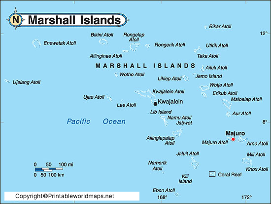
The Labeled Map of Marshall Islands helps you understand the geography, atolls, capital city, major settlements, and political divisions of the Republic of the Marshall Islands. Located in the central Pacific Ocean, the country is part of Micronesia and consists of 29 coral atolls and 5 isolated islands, spread across an Exclusive Economic Zone (EEZ) of more than 2 million square kilometers. Although its land area is only about 181 km² (70 sq mi), the nation covers one of the world’s largest ocean territories.
A labeled map makes it easier to identify important locations such as Majuro, Kwajalein, Jaluit, Arno, and the two major island chains, Ratak (Sunrise) in the east and Ralik (Sunset) in the west. Whether you’re a student, teacher, traveler, or geography enthusiast, this guide provides an accurate overview of the country’s geography, capital, major cities, and administrative atolls.
- World map with continents
- Physical world map
- Political world map
- Labeled map of Asia
- Labeled map of Africa
- Labeled map of Europe
- Labeled map of South America
- World time zone map
- Labeled map of World
- Blank map of world
- Labeled map of North America
- Blank map of Asia
- World map with oceans
- World map poster
Labeled Map of Marshall Islands
Labeled Map of Marshall Islands displays the country’s islands, atolls, surrounding Pacific Ocean, neighboring countries, and major settlements. The Marshall Islands lie approximately halfway between Hawaii and Australia and share maritime boundaries with Kiribati, the Federated States of Micronesia, Nauru, and Wake Island (U.S.).
The nation has around 1,156 individual islands and islets grouped into 29 atolls. Since there are no mountains or rivers, most islands rise only a few meters above sea level, making them particularly vulnerable to climate change and sea-level rise.
Quick Facts
| Feature | Details |
|---|---|
| Official Name | Republic of the Marshall Islands |
| Capital | Majuro |
| Largest City | Majuro |
| Region | Micronesia, Oceania |
| Total Land Area | 181 km² (70 sq mi) |
| Total Atolls | 29 |
| Isolated Islands | 5 |
| Official Languages | Marshallese, English |
| Currency | United States Dollar (USD) |
| Time Zone | UTC +12 |
| Population (2025 estimate) | Around 39,000–42,000 |
Labeled Map of Marshall Islands with States
Although commonly searched as a Labeled Map of Marshall Islands with States, the country does not have states like the United States or Australia. Instead, it is divided into 24 inhabited municipalities, mostly based on individual atolls and islands.
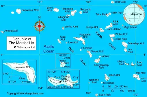
Some of the most important administrative atolls include:
- Majuro
- Kwajalein
- Arno
- Jaluit
- Ailinglaplap
- Maloelap
- Mili
- Wotje
- Likiep
- Rongelap
A labeled administrative map clearly identifies these municipalities and their geographical locations.
Labeled Map of Marshall Islands with Cities
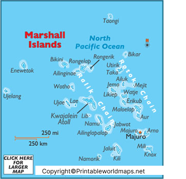
A Labeled Map of Marshall Islands with Cities highlights the country’s major urban centers and settlements.
Major Cities and Towns
| City | Atoll | Importance |
|---|---|---|
| Majuro | Majuro Atoll | Capital and largest city |
| Ebeye | Kwajalein Atoll | Second-largest population center |
| Jabor | Jaluit Atoll | Historic administrative center |
| Laura | Majuro Atoll | Residential district |
| Arno Village | Arno Atoll | Local administrative settlement |
Majuro and Ebeye are the country’s most densely populated urban areas and serve as important economic and governmental centers.
Labeled Marshall Islands Map with Capital
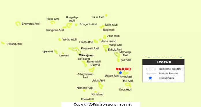
A Labeled Marshall Islands Map with Capital identifies Majuro, the national capital located on Majuro Atoll.
Majuro serves as the country’s:
- Seat of government
- Commercial center
- Main international port
- Financial hub
- Location of Marshall Islands International Airport (MAJ)
The capital consists of over 60 small islands connected by roads and causeways, forming one of the most important urban areas in Micronesia.
Geography of the Marshall Islands
The Marshall Islands extend across nearly 1,300 kilometers (810 miles) from northwest to southeast.
Geographical highlights include:
- Two parallel island chains:
- Ratak Chain (Sunrise Islands)
- Ralik Chain (Sunset Islands)
- Coral reef ecosystems
- White sandy beaches
- Large lagoons
- Tropical marine climate
- No permanent rivers
- Highest natural elevation is only about 10 meters (33 feet) above sea level
These unique geographical features make labeled maps especially useful for studying the country’s physical layout.
Climate
The Marshall Islands experience a tropical climate throughout the year.
- Average temperature: 27°C–30°C
- Wet season: May–November
- Dry season: December–April
- Frequent influence from El Niño and La Niña weather patterns
Economy
The economy depends largely on:
- Fishing
- Copra production
- Government services
- U.S. financial assistance under the Compact of Free Association
- Tourism
- Handicrafts
Fishing remains one of the country’s most valuable natural resources.
Interesting Facts About the Marshall Islands
- The Marshall Islands contains over 1,100 islands and islets.
- Bikini Atoll became famous for U.S. nuclear testing between 1946 and 1958.
- The country uses the United States Dollar (USD).
- Marshallese and English are both official languages.
- Majuro is connected by causeways across multiple small islands.
- The islands have one of the world’s largest Exclusive Economic Zones compared to their land area.
- Traditional stick charts were historically used by Marshallese navigators to navigate the Pacific Ocean.
- The Marshall Islands became independent in 1986 under the Compact of Free Association with the United States.
Why Use a Labeled Map of Marshall Islands?
A labeled map is useful for:
- Geography assignments
- School and university projects
- UPSC and competitive exam preparation
- Travel planning
- Learning about Pacific island nations
- Understanding atolls, municipalities, and major cities
FAQs
Where are the Marshall Islands located?
The Marshall Islands are located in the central Pacific Ocean in the Micronesia region of Oceania, between Hawaii and Australia.
What is the capital of the Marshall Islands?
Majuro is the capital and largest city of the Republic of the Marshall Islands.
How many atolls are in the Marshall Islands?
The country consists of 29 coral atolls and 5 isolated islands, comprising over 1,100 individual islands and islets.
Does the Marshall Islands have states?
No. The Marshall Islands do not have states. Instead, they are administered through municipalities based on atolls and islands.
What does a labeled map of the Marshall Islands show?
It shows the capital, major cities, municipalities, atolls, island chains, neighboring countries, and important geographical features.
What language is spoken in the Marshall Islands?
Marshallese and English are the country’s official languages.
Which currency is used in the Marshall Islands?
The United States Dollar (USD) is the official currency.
Why is the Marshall Islands famous?
The country is known for its coral atolls, traditional ocean navigation, rich marine biodiversity, and the historic Bikini Atoll nuclear test site.
Conclusion
The Labeled Map of Marshall Islands offers an easy way to understand one of the Pacific Ocean’s most unique island nations. From identifying Majuro, Ebeye, and the country’s major atolls to learning about its geography, municipalities, and history, a labeled map provides valuable information for students, researchers, and travelers alike. Despite its small land area, the Marshall Islands possesses an enormous maritime territory and a fascinating cultural heritage that makes it an important nation in Oceania.









