
The Labeled Map of Mauritius helps readers understand the geography, districts, capital city, major towns, rivers, and surrounding islands of this beautiful Indian Ocean nation. Mauritius is officially known as the Republic of Mauritius and lies approximately 900 km east of Madagascar and about 2,000 km off the southeast coast of mainland Africa. It is one of Africa’s most prosperous island countries and is famous for its multicultural society, tropical beaches, volcanic landscapes, and thriving tourism industry.
Whether you are a student, traveler, teacher, or geography enthusiast, this Labeled Map of Mauritius provides an easy way to identify the country’s administrative divisions, important cities, physical features, and political boundaries.
- World map with continents
- Physical world map
- Political world map
- Labeled map of Asia
- Labeled map of Africa
- Labeled map of Europe
- Labeled map of South America
- World time zone map
- Labeled map of World
- Blank map of world
- Labeled map of North America
- Blank map of Asia
- World map with oceans
- World map poster
Labeled Map of Mauritius
Mauritius is an island nation formed primarily through volcanic activity millions of years ago. Besides the main island, the Republic of Mauritius also includes several smaller islands such as Rodrigues, Agaléga Islands, St. Brandon (Cargados Carajos Shoals), and other islets.
The country covers a total area of approximately 2,040 square kilometres (787 square miles) and has an estimated population of around 1.27 million people. Mauritius consistently ranks among Africa’s most developed countries with a high Human Development Index (HDI) and a diversified economy based on tourism, financial services, manufacturing, agriculture, and information technology.
The island is surrounded by one of the world’s largest coral reef systems, protecting its lagoons and beaches while supporting rich marine biodiversity.
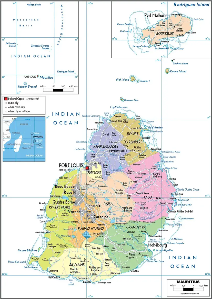
Quick Facts about Mauritius
- Official Name: Republic of Mauritius
- Continent: Africa
- Capital: Port Louis
- Largest City: Port Louis
- Official Language: English
- Widely Spoken Languages: French and Mauritian Creole
- Currency: Mauritian Rupee (MUR)
- Area: 2,040 km²
- Population: Around 1.27 million
- Time Zone: UTC +4
- Driving Side: Left
Mauritius has 25 major rivers and numerous smaller streams. The Grand River South East is the country’s longest river at approximately 34 km, followed by the Black River, Grand River North East, Poste River, and Rivière du Rempart. The country is also home to Black River Gorges National Park, which protects native forests and endangered wildlife.
Labeled Map of Mauritius with States (Districts)
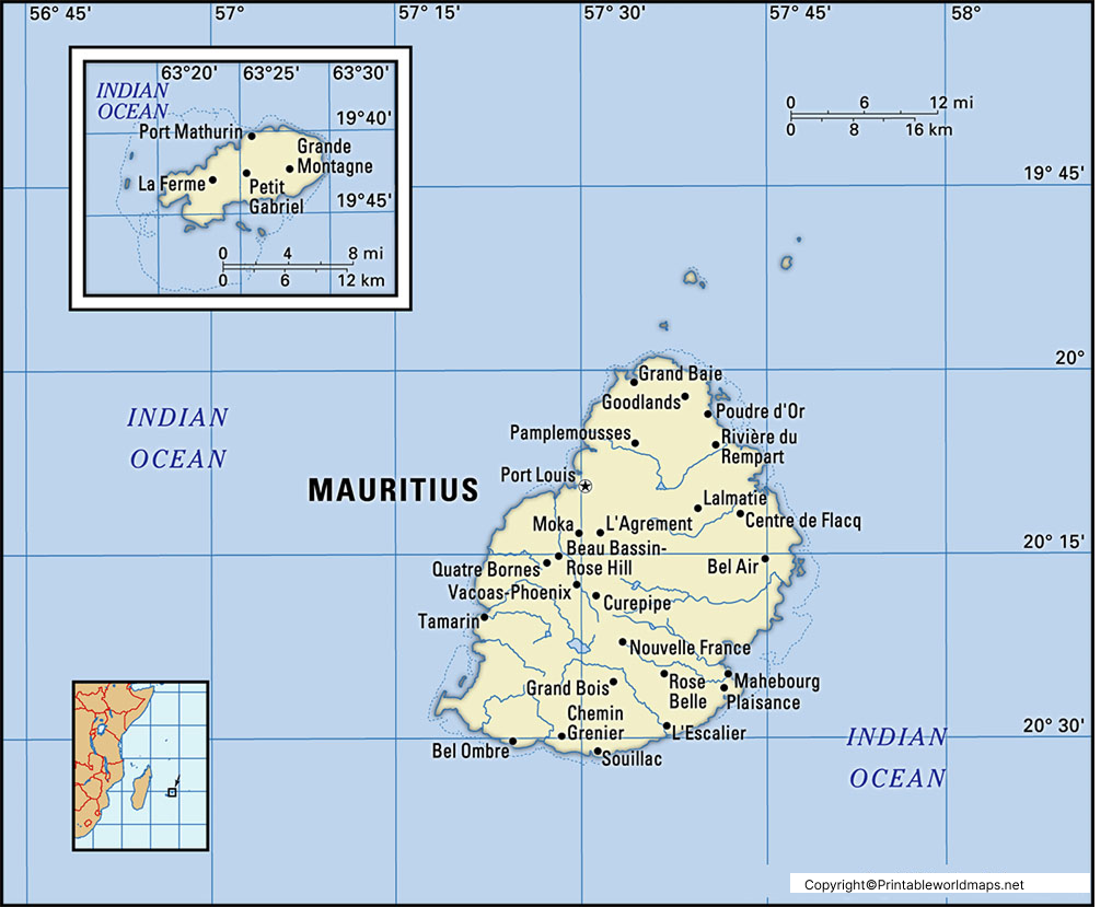
Although many people refer to them as states, Mauritius is officially divided into 9 administrative districts. These districts include one capital city, several municipalities, towns, and more than one hundred villages.
The nine districts of Mauritius are:
- Black River
- Flacq
- Grand Port
- Moka
- Pamplemousses
- Plaines Wilhems
- Port Louis
- Rivière du Rempart
- Savanne
Each district has its own local administration and contributes to the country’s economy through agriculture, tourism, manufacturing, education, or financial services.
The Plaines Wilhems District is the most urbanized region and includes the major towns of Beau Bassin-Rose Hill, Curepipe, Quatre Bornes, and Vacoas-Phoenix.
Labeled Map of Mauritius with Cities
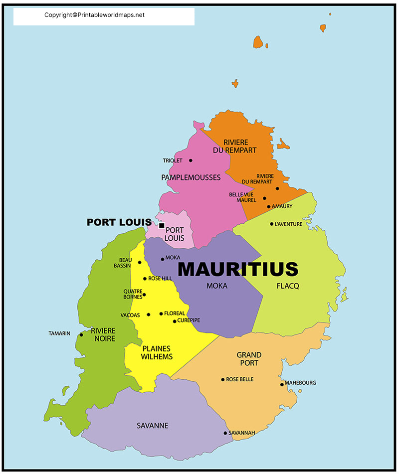
The Labeled Map of Mauritius also highlights the country’s important cities and towns, making it easier to understand urban development and transportation networks.
Major cities and towns include:
- Port Louis
- Beau Bassin-Rose Hill
- Curepipe
- Quatre Bornes
- Vacoas-Phoenix
- Centre de Flacq
- Mahébourg
- Goodlands
- Triolet
- Rose Belle
These cities serve as commercial, educational, residential, and tourism centers. Port Louis remains the country’s financial and administrative hub, while Curepipe is known for its cooler climate due to its higher elevation.
Labeled Mauritius Map with Capital
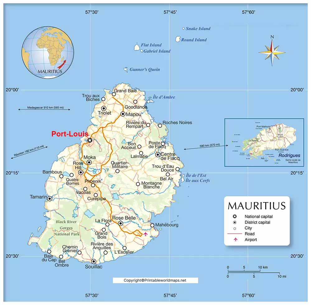
The Labeled Map of Mauritius with Capital clearly identifies Port Louis, the nation’s capital and largest city.
Located on the northwestern coast of Mauritius, Port Louis is the country’s primary seaport and economic center. The city is surrounded by mountain ranges including Pieter Both and Le Pouce, creating one of the most recognizable landscapes in Mauritius.
Port Louis is home to:
- Government offices
- Parliament of Mauritius
- Port Louis Harbour
- Central Market
- Caudan Waterfront
- Financial and banking institutions
- Museums and historical landmarks
The city is connected to the rest of the island through modern highways, making travel convenient for both residents and visitors.
Geography of Mauritius
The island features volcanic mountains, fertile plains, tropical forests, waterfalls, rivers, coral reefs, and white-sand beaches. The highest point in Mauritius is Piton de la Petite Rivière Noire, reaching 828 metres (2,717 feet) above sea level.
The tropical maritime climate provides warm temperatures throughout the year, with the rainy season generally occurring between November and April.
Economy of Mauritius
Mauritius has transformed from an agriculture-based economy into one of Africa’s strongest diversified economies. Major industries include:
- Tourism
- Financial Services
- Textile Manufacturing
- Sugar Production
- Information Technology
- Seafood Processing
- Real Estate
- Renewable Energy
The country is recognized for its political stability, business-friendly environment, and high standard of living.
Interesting Facts about Mauritius
- Mauritius is one of the safest and most developed countries in Africa.
- The extinct Dodo Bird was native to Mauritius.
- The island is almost completely surrounded by coral reefs.
- Mauritius has no standing army.
- It is one of the world’s top honeymoon destinations.
- The country celebrates cultural festivals from Hindu, Christian, Muslim, Chinese, and Creole communities.
- UNESCO has recognized Aapravasi Ghat and Le Morne Cultural Landscape as World Heritage Sites.
- Mauritius ranks among Africa’s leading countries for ease of doing business and quality of life.
Why Use a Labeled Map of Mauritius?
A Labeled Map of Mauritius is useful for:
- School geography assignments
- Competitive exam preparation
- Learning district names
- Understanding physical geography
- Travel planning
- Educational presentations
- Research projects
- Tourism studies
The map allows users to quickly identify the country’s districts, capital, major cities, rivers, mountains, and surrounding islands in a simple visual format.
FAQs – Labeled Map of Mauritius
What does a labeled map of Mauritius show?
A labeled map of Mauritius shows the country’s districts, capital city, major towns, rivers, surrounding islands, and important geographical features. It helps students, travelers, and researchers understand the country’s political and physical layout.
What is the capital of Mauritius?
The capital of Mauritius is Port Louis. It is the country’s largest city, main seaport, and the center of government, commerce, and finance.
How many districts are there in Mauritius?
Mauritius is divided into 9 administrative districts:
Black River
Flacq
Grand Port
Moka
Pamplemousses
Plaines Wilhems
Port Louis
Rivière du Rempart
Savanne
Is Mauritius divided into states or districts?
Mauritius is officially divided into districts, not states. Many educational resources use the term “states” informally, but the correct administrative divisions are districts.
What are the major cities in Mauritius?
Some of the major cities and towns in Mauritius include Port Louis, Beau Bassin-Rose Hill, Curepipe, Quatre Bornes, Vacoas-Phoenix, Centre de Flacq, Goodlands, and Mahébourg.
Where is Mauritius located?
Mauritius is an island country in the Indian Ocean, located about 900 km east of Madagascar and approximately 2,000 km southeast of mainland Africa.
What is the total area of Mauritius?
Mauritius has a total land area of approximately 2,040 square kilometres (787 square miles), including Rodrigues and other smaller islands.
What is Mauritius famous for?
Mauritius is famous for its white-sand beaches, coral reefs, luxury resorts, multicultural heritage, extinct dodo bird, volcanic landscapes, and thriving tourism industry.
Which is the longest river in Mauritius?
The Grand River South East is the longest river in Mauritius, stretching approximately 34 kilometres (21 miles).
Why is a labeled map of Mauritius useful?
A labeled map of Mauritius is useful for geography studies, school assignments, competitive exam preparation, travel planning, and understanding the country’s districts, cities, and physical features.
What language is spoken in Mauritius?
English is the official language of Mauritius, while Mauritian Creole and French are the most widely spoken languages in daily life.
Which continent does Mauritius belong to?
Mauritius is geographically located in the Indian Ocean but is considered part of the African continent.
References
- Government of Mauritius. https://govmu.org/
- Statistics Mauritius. https://statsmauritius.govmu.org/
- World Bank – Mauritius. https://www.worldbank.org/en/country/mauritius
- United Nations Data. https://data.un.org/
- Encyclopaedia Britannica – Mauritius. https://www.britannica.com/place/Mauritius









