
The Yellow River on world map helps you locate one of China’s most important rivers and understand its route across northern China. Also known as the Huang He, the Yellow River is China’s second-longest river and an important part of the country’s geography, agriculture, and ancient history. It is approximately 5,464 kilometres (3,395 miles) long.
In this guide, you can explore the Yellow River map of China, discover its source and mouth, understand its major geographical regions, and access printable maps for educational and research purposes.
Yellow River on World Map
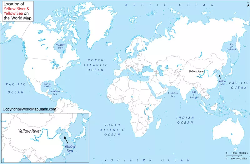
The Yellow River is located in northern China, in East Asia. It begins in the Bayan Har Mountains in Qinghai Province and flows generally eastward before reaching the Bohai Sea. Its route crosses varied landscapes, including highlands, the Loess Plateau, and the North China Plain.
The river is known for carrying large quantities of fine sediment, particularly loess-derived material. This sediment gives the water its characteristic yellow-brown appearance and has influenced the development of the surrounding landscape.
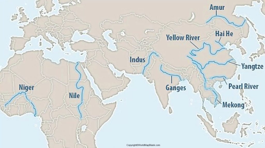
The Yellow River is also historically significant because its valley supported early Chinese communities and agricultural development. However, its sediment load and history of flooding have made river management important for people living along its banks.
Yangtze River Map
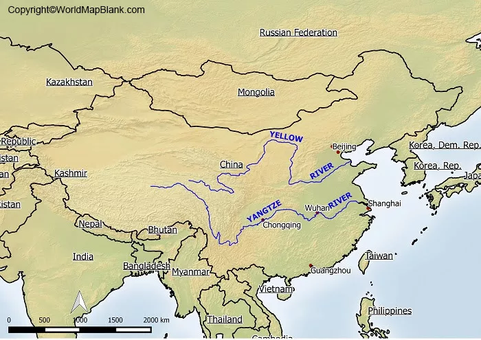
The Yangtze River, also called the Chang Jiang, is China’s longest river and flows through central China toward the East China Sea. It is geographically distinct from the Yellow River, which flows across northern China and reaches the Bohai Sea.
Comparing a Yellow River map with a Yangtze River map helps readers understand the distribution of China’s major river systems.
The Yangtze is approximately 6,300 kilometres (3,915 miles) long, compared with approximately 5,464 kilometres (3,395 miles) for the Yellow River. Length figures are rounded and can vary slightly among reference sources. National Geographic: Asia’s Physical Geography
The two rivers have played important roles in China’s history, agriculture, settlement patterns, and economic development. Their different routes also help explain the diversity of China’s physical geography.
7 Amazing Facts About the Yellow River
1. It is China’s second-longest river
The Yellow River is approximately 5,464 kilometres long, making it one of Asia’s major river systems.
2. It is also called the Huang He
Huang He is the river’s name in Chinese. The English name Yellow River refers to the yellowish appearance caused by sediment carried in its water.
3. It begins in western China
The river’s headwaters originate in the Bayan Har Mountains in Qinghai Province, in the highlands of western China.
4. It flows into the Bohai Sea
After crossing northern China, the river reaches the Bohai Sea along the coast of Shandong Province.
5. It helped shape ancient Chinese civilization
The Yellow River Valley was an important centre of early Chinese settlement and agricultural development. The river is often called the “Mother River” because of its historical and cultural importance.
6. Its sediment affects the surrounding landscape
The river carries substantial amounts of sediment from the Loess Plateau. This material contributes to the river’s distinctive colour and affects the landforms along its route.
7. It has a long history of flooding
Floods and changes in the river’s course have affected communities across northern China. Embankments, reservoirs, irrigation systems, and other water-management measures help manage the river’s risks and resources.
Yellow River Location on World Map
The Yellow River lies in the northern part of China. To locate it on a world map, first find East Asia and then identify China. The river begins in the west, in the highlands of Qinghai, and follows a winding route across northern China toward the Bohai Sea.
Its source is in the Bayan Har Mountains, while its mouth lies on the coast of Shandong Province near the Bohai Sea. This west-to-east journey crosses several different physical environments.
When studying the map, look for three broad sections of the river:
- Upper course: The river begins in highland and mountainous terrain.
- Middle course: It crosses the Loess Plateau, where erosion contributes substantial sediment to the river.
- Lower course: It flows across the North China Plain toward the Bohai Sea.
These sections provide a useful overview of the river’s changing landscape. The boundaries between them are geographical approximations rather than universally fixed dividing lines.
Printable Yellow River on World Map
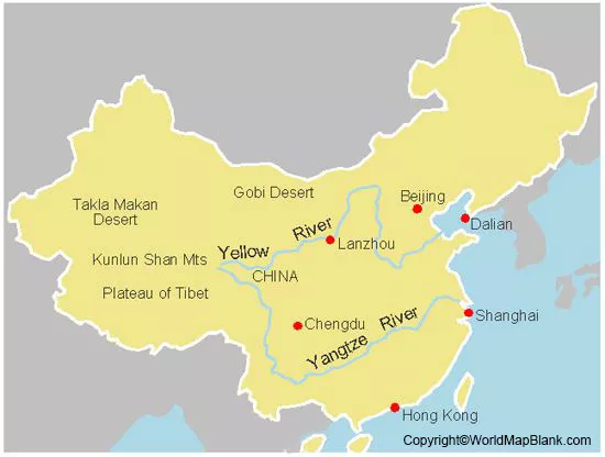
A printable Yellow River map is useful for classroom lessons, geography assignments, presentations, and independent study. A clear map can help readers identify the river’s location, trace its route, and understand its relationship with other physical features of China.
Before printing, check whether the map includes labels, a scale, a north arrow, and the names of relevant regions. These details can make the map easier to interpret.
For a simple classroom activity, print the map and ask students to mark the source, the main direction of flow, the lower course, and the Bohai Sea. They can also compare the Yellow River’s route with that of the Yangtze River.
Yellow River Map of China
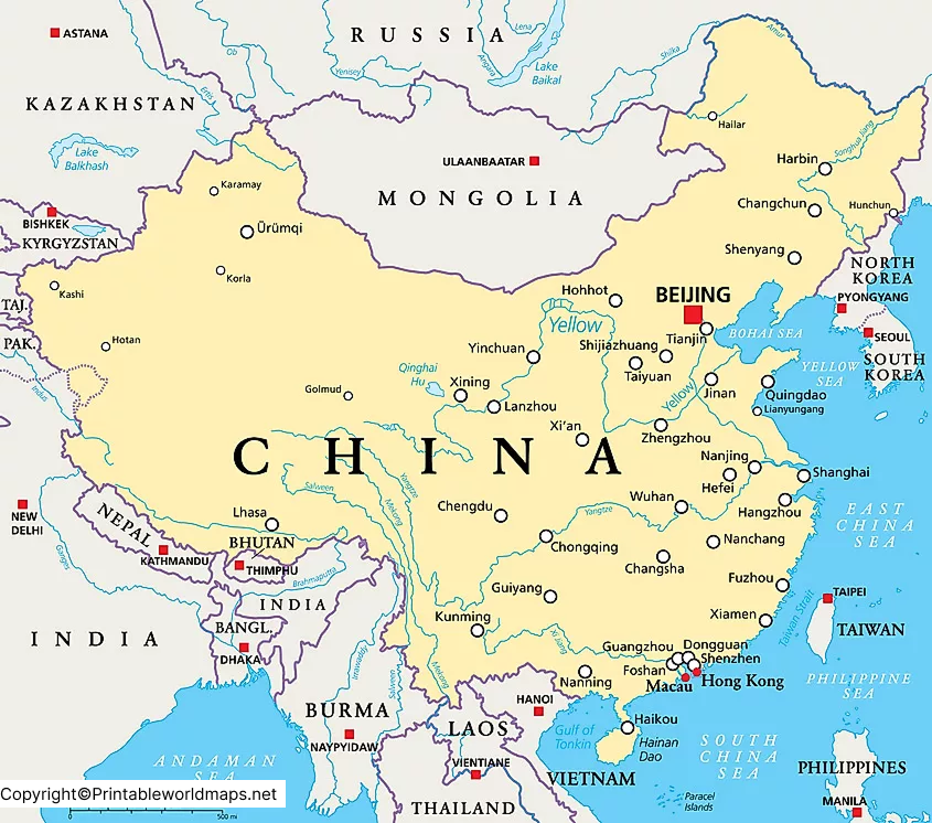
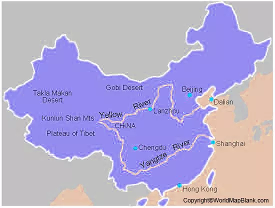
A Yellow River map of China helps readers follow the river from its mountainous source to its outlet on the coast. The river passes through or along the boundaries of several provincial-level administrative regions, including Qinghai, Sichuan, Gansu, Ningxia, Inner Mongolia, Shaanxi, Shanxi, Henan, and Shandong.
The exact route is easier to understand when the map identifies major bends, neighbouring provinces, tributaries, and the lower river’s approach to the Bohai Sea.
For students, teachers, and geography enthusiasts, a labelled map can be useful for learning Chinese physical geography, locating important river basins, and understanding how rivers connect inland regions with coastal areas.
Why Is the Yellow River Important?
The Yellow River is important for several interconnected reasons:
- Agriculture: Its water supports irrigation and farming in parts of northern China.
- History and culture: The river valley is closely associated with the development of early Chinese civilization.
- Geography: Its route demonstrates how rivers shape plains, plateaus, valleys, and coastal environments.
- Water management: Flood control, sediment management, and water allocation are important issues throughout the river basin.
- Education: Maps of the Yellow River help students understand China’s landscape, river systems, and regional geography.
The river provides valuable resources, but it also presents challenges. Sediment accumulation, flooding, water demand, and environmental pressures make the sustainable management of the basin an important topic.
How to Use a Yellow River Map for Learning
A Yellow River map can be used for more than simply locating the river. Follow these steps to study it effectively:
- Locate China on a world map and identify the river in northern China.
- Mark the source in the Bayan Har Mountains.
- Trace the river eastward across its major geographical regions.
- Identify the lower course and the Bohai Sea.
- Compare the river’s route with the Yangtze River.
- Use a labelled map to identify surrounding provinces and major cities where shown.
These activities can help students improve map-reading skills and connect physical geography with historical and environmental topics.
Frequently Asked Questions About the Yellow River
1. Where is the Yellow River located on a world map?
The Yellow River is located in northern China in East Asia. It begins in Qinghai Province and flows eastward toward the Bohai Sea.
2. What is the length of the Yellow River?
The Yellow River is approximately 5,464 kilometres (3,395 miles) long. Published figures may vary slightly depending on the source and measurement method.
3. What is the Chinese name of the Yellow River?
The river is called Huang He in Chinese. It is also known as the Huang Ho in some older English-language references.
4. Where does the Yellow River start and end?
The river begins in the Bayan Har Mountains in Qinghai Province and empties into the Bohai Sea on China’s eastern coast.
5. Why is the Yellow River yellow?
The river carries fine sediment, including material eroded from the Loess Plateau. This sediment gives the water its characteristic yellow-brown colour.
6. Is the Yellow River longer than the Yangtze River?
No. The Yangtze River is longer. It measures approximately 6,300 kilometres, while the Yellow River measures approximately 5,464 kilometres.
7. Can I download a printable Yellow River map?
Yes. You can use the printable PDF links provided in this article for educational and personal reference. Check the individual file for its labels, scale, and print quality before using it in an assignment.
8. Why is the Yellow River historically important?
The Yellow River Valley supported early Chinese communities and agricultural development. Its long history of settlement, farming, flooding, and river management makes it an important region in Chinese history.
Reference links
https://education.nationalgeographic.org/resource/huang-he-valley
https://education.nationalgeographic.org/resource/asia
https://education.nationalgeographic.org/resource/understanding-rivers
https://www.nationalgeographic.com/magazine/article/china-yellow-river-fragile-landscape
More Free and Printable Maps for Download
Below you’ll find a link collection to other interesting maps of different parts of the world. We offer world maps, country and continent maps as well as physical and other maps. All our maps are available for free download as PDF files.
World Maps
Continent Maps
- Political Map of Europe
- Blank Map of Europe
- Labeled Map of Africa
- Blank Map of South America
- Blank Map of Asia
- Political Map of Asia
- Physical Map of Asia
- Labeled Map of Europe
Country Maps
- Blank Map of the United States
- Map of Ukraine with Regions
- Blank Map of Russia
- Blank Map of China
- Labeled Map of Bahrain









