
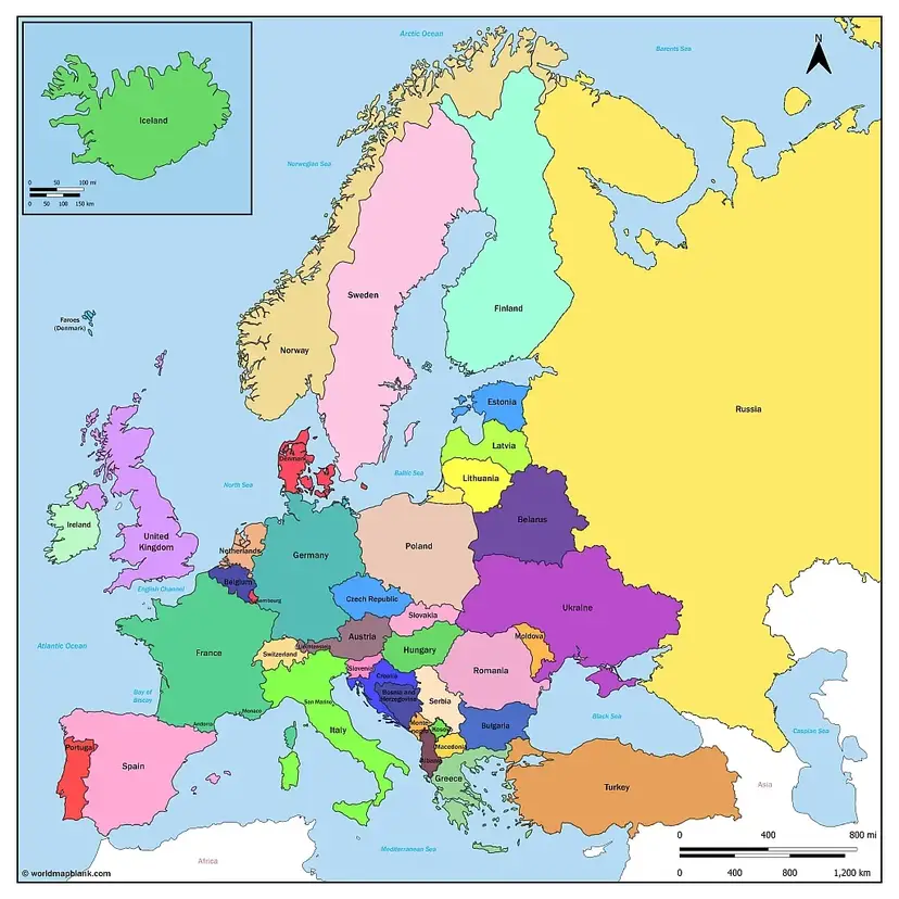

Explore a Europe map with countries to learn about European borders, country names, capital cities, and political divisions. This page offers free printable political maps of Europe in PDF format, including maps with capitals, labeled countries, and historical political boundaries.
These printable Europe maps are useful for students, teachers, geography enthusiasts, and anyone who wants a clear reference map for studying the continent.
You can choose a map with country names, identify capital cities, explore historical borders, or print a copy for classroom activities. You can also explore our free continent maps, blank map of Europe, and Europe map worksheets.
Europe Political Map
A political map of Europe shows countries, international boundaries, and, depending on the version, capital cities and major urban centers. It is useful for understanding the political geography of the continent.
Europe is a continent, while the European Union (EU) is a political and economic union. The EU has 27 member countries, but many European countries are not EU members.
Geographical definitions of Europe also include parts of Russia and Turkey. The precise number of countries associated with Europe can vary depending on the geographical definition and the treatment of transcontinental countries and disputed territories.
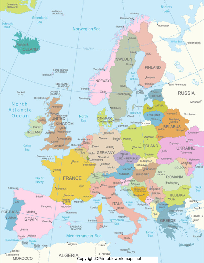
This version includes country names, European capitals, and selected major cities. It is suitable for geography lessons, reference, and printing.
Map of Europe with Countries
A Europe map with countries makes it easier to identify individual nations and understand how they are positioned in relation to their neighbors. A labeled map is particularly helpful when learning country locations, while an unlabeled map is better for practice and testing geographical knowledge.
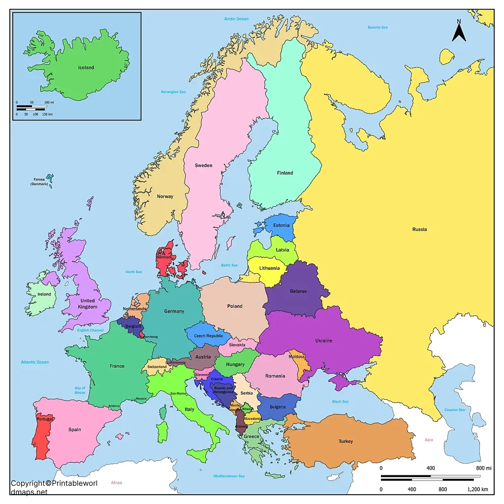
The map identifies countries and major surrounding water bodies, including the Atlantic Ocean, Mediterranean Sea, and Black Sea. Check the PDF’s page dimensions before printing to ensure that labels remain legible.
Cold War Map of Europe Political
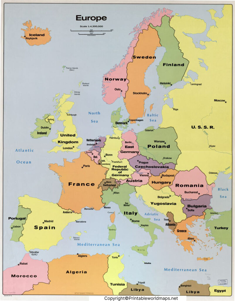
Europe’s political boundaries changed considerably during the 20th century. During the Cold War, Germany was divided into East Germany and West Germany, while Czechoslovakia, Yugoslavia, and the Soviet Union existed as larger political entities.
Europe’s political boundaries changed considerably during the 20th century. During the Cold War, Germany was divided into East Germany and West Germany, while Czechoslovakia, Yugoslavia, and the Soviet Union existed as larger political entities.
For studying regional geography, Europe is often divided into Northern, Southern, Eastern, and Western Europe. Central Europe is also commonly used as a regional grouping. These categories are useful, but the exact country groupings vary between institutions and geographical conventions.
Political Map of Europe with Capitals
A political map of Europe with capitals helps learners connect each country with its seat of government. It can be used for school assignments, geography quizzes, classroom displays, and general reference.
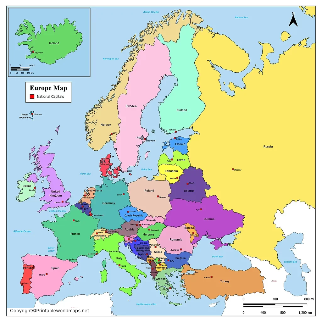
Some countries have complex political or constitutional arrangements, and the capital shown on a general map may not tell the whole story. For detailed research, consult official national or international sources.
Printable Europe Political Map
Political maps are also useful for understanding the European Union’s enlargement over time. The EU began with six founding countries in the European Economic Community in 1957, and its membership expanded through successive enlargement rounds.
As of October 2026, the European Union has 27 member states. The United Kingdom left the EU on 31 January 2020. Ukraine is an EU candidate country, not a member state.
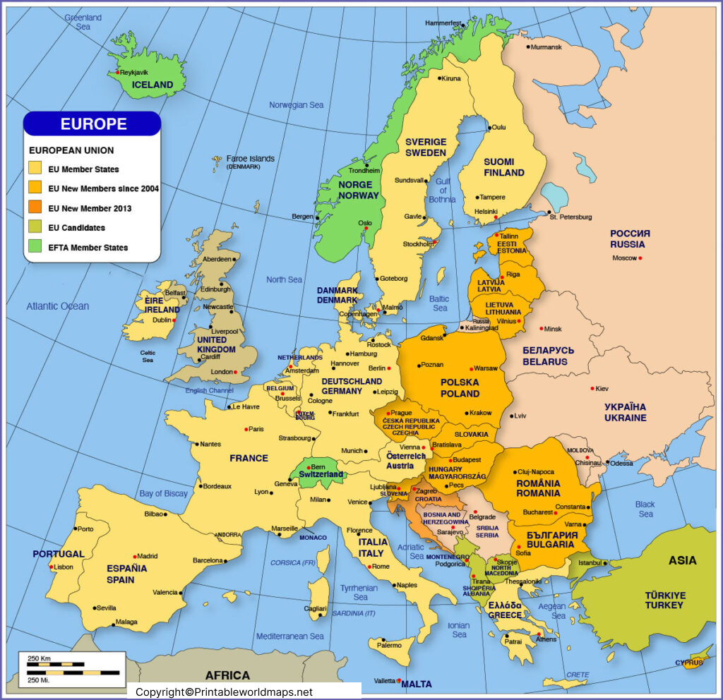
Europe Political Map Labeled
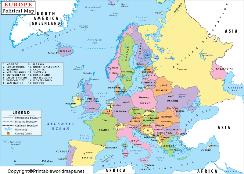
Europe extends from the Atlantic Ocean in the west to the Ural region in the east under a commonly used geographical convention. The Arctic Ocean lies to the north, while the Mediterranean and Black seas are important geographical features to the south and southeast.
A labeled political map helps readers locate countries, compare their positions, and understand neighboring states. Depending on the map, it may also display capital cities, major cities, seas, and surrounding oceans.
European Countries and Their Capitals
The table below provides a useful reference for commonly recognized European countries and their capitals. Transcontinental countries and territories with disputed or special status require additional context; the list is not intended to settle every question about Europe’s boundaries or state recognition.
| Country | Capital |
|---|---|
| Albania | Tirana |
| Andorra | Andorra la Vella |
| Austria | Vienna |
| Belarus | Minsk |
| Belgium | Brussels |
| Bosnia and Herzegovina | Sarajevo |
| Bulgaria | Sofia |
| Croatia | Zagreb |
| Cyprus | Nicosia |
| Czechia | Prague |
| Denmark | Copenhagen |
| Estonia | Tallinn |
| Finland | Helsinki |
| France | Paris |
| Germany | Berlin |
| Greece | Athens |
| Hungary | Budapest |
| Iceland | Reykjavík |
| Ireland | Dublin |
| Italy | Rome |
| Latvia | Riga |
| Liechtenstein | Vaduz |
| Lithuania | Vilnius |
| Luxembourg | Luxembourg |
| Malta | Valletta |
| Moldova | Chișinău |
| Monaco | Monaco |
| Montenegro | Podgorica |
| Netherlands | Amsterdam |
| North Macedonia | Skopje |
| Norway | Oslo |
| Poland | Warsaw |
| Portugal | Lisbon |
| Romania | Bucharest |
| Russia | Moscow |
| San Marino | San Marino |
| Serbia | Belgrade |
| Slovakia | Bratislava |
| Slovenia | Ljubljana |
| Spain | Madrid |
| Sweden | Stockholm |
| Switzerland | Bern |
| Türkiye (Turkey) | Ankara |
| Ukraine | Kyiv |
| United Kingdom | London |
| Vatican City | Vatican City |
The Netherlands has Amsterdam as its constitutional capital, while the Dutch government and parliament are located in The Hague. Russia and Türkiye are transcontinental countries, and their inclusion in European country lists depends on the geographical or political context.
England, Scotland, Wales, and Northern Ireland are constituent countries of the United Kingdom, not separate sovereign states. Kosovo is recognized as independent by many countries but not by all; its status is disputed.
How to Choose the Right Europe Map PDF
Choose a map based on what you need to learn or teach:
- Political map: Best for country borders and political divisions.
- Labeled map: Useful for identifying countries without memorizing locations from scratch.
- Map with capitals: Best for geography revision and quizzes.
- Blank map: Useful for labeling exercises and classroom tests.
- Historical map: Helps compare Europe’s political boundaries across different periods.
- European Union map: Useful for distinguishing EU member states from other European countries.
Printing Tips
- Open the PDF using a PDF reader.
- Select A4 or A5 paper according to the file’s actual page size.
- Choose landscape or portrait orientation as appropriate.
- Use fit-to-page scaling if the map is cut off.
- Select a good-quality print setting so small country names remain readable.
For study activities, print a labeled map for reference and a blank map for practice.
Frequently Asked Questions About the Europe Map with Countries
1. Where can I download a Europe map with countries for free?
You can use the PDF links on this page to access printable political maps, country maps, and maps with capitals. Check each file’s page size and print settings before printing.
2. How many countries are in Europe?
There is no single universally accepted count because geographical boundaries, transcontinental countries, and disputed territories are treated differently by different sources. Use a clearly defined country list when an exact count is required.
3. Is Europe the same as the European Union?
No. Europe is a continent, whereas the European Union is a political and economic union. The EU has 27 member countries as of October 2026, and several European countries are not EU members.
4. What is a political map of Europe?
A political map shows countries and their boundaries. Depending on the map, it may also identify capitals, major cities, and surrounding bodies of water.
5. Can I print a Europe map for school?
Yes. The PDF maps on this page can be used for educational purposes, provided the applicable terms of use permit your intended use. Check the PDF dimensions and print preview before printing.
6. What is the difference between a labeled and a blank Europe map?
A labeled map includes country names and may include capitals. A blank map removes some or all labels, making it useful for quizzes, worksheets, and geography practice.
7. Does a Europe political map include Russia and Türkiye?
Some maps include both countries because parts of their territories lie in Europe. The coverage depends on the map’s geographical definition and purpose.
8. What is the best Europe map for learning capital cities?
Choose a political map that labels both countries and capitals. A blank map can then be used to test recall and improve familiarity with European geography.
Reference links
https://european-union.europa.eu/principles-countries-history/eu-countries_en
https://commission.europa.eu/topics/enlargement_en
https://www.coe.int/en/web/portal/46-member-states
More Free Maps to Download and Print
Have you found the political Europe map you were looking for? If not, maybe you will find a convenient map of Europe or any other map you might need via the link selection below. You can also use our search bar at the top of the page to find more maps of the world, its continents and many countries.
We offer physical, blank and political maps but also river and mountain maps of different regions of the world. You can download them all as PDF files and print them out as often as you like.
Other Maps of Europe
European Country Maps
- Map of France with Regions
- Blank Map of France
- Bulgaria Map Blank
- Austria Map Blank
- Map of Austria with States
- Map of Sweden with States and Cities
