
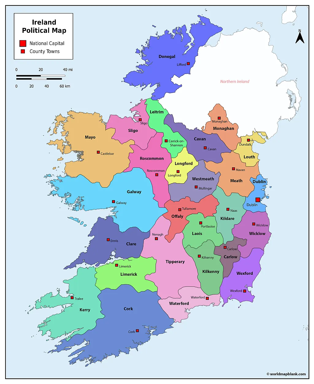
Do you need a printable Ireland map for school, teaching, geography projects, travel planning, or personal reference? This page provides free maps of Ireland with counties, towns, cities, administrative boundaries, and major geographic features in printable PDF formats.
Our printable Ireland map collection includes county maps, maps showing county towns and additional towns, and a general labeled map with major roads, railways, airports, and other geographic features.
You can download and print these Ireland maps for educational and personal use.
Map of Ireland Counties
The Republic of Ireland is located in northwestern Europe and occupies most of the island of Ireland. The island is traditionally divided into four provinces: Leinster, Munster, Connacht, and Ulster. These provinces have historical, cultural, and sporting importance but do not function as modern administrative governments. Three of the nine counties of Ulster are within the Republic of Ireland.
The Republic of Ireland has 26 counties. Modern local government is organized through 31 local authorities, including county councils, city councils, and city-and-county councils.
Our first Ireland map with counties shows the county boundaries of the Republic of Ireland and includes Northern Ireland for geographic context.
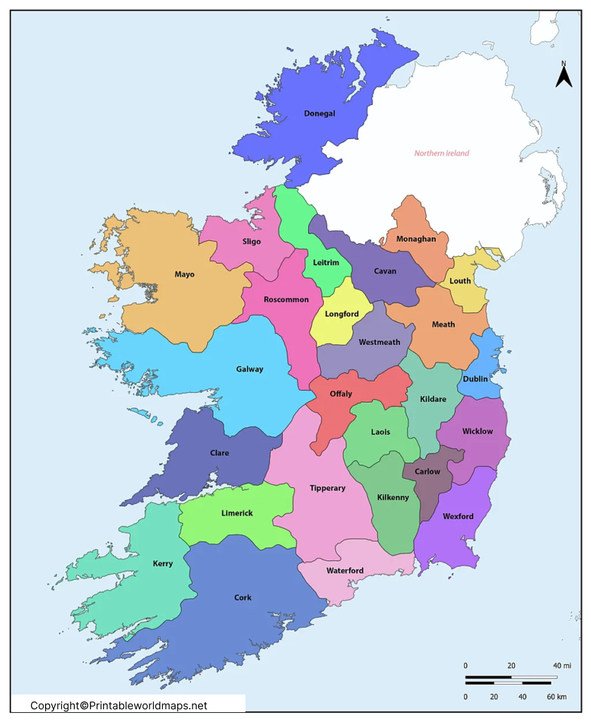
How Many Counties are in Ireland?
The Republic of Ireland has 26 counties. The island of Ireland as a whole has 32 traditional counties, with six counties forming Northern Ireland. The distinction between the island’s traditional counties and the Republic’s modern administrative counties is important when using an Ireland county map. Tailte Éireann’s current statutory-boundary dataset confirms that there are 26 counties in the Republic of Ireland.
The 26 counties of the Republic of Ireland are:
- Carlow
- Cavan
- Clare
- Cork
- Donegal
- Dublin
- Galway
- Kerry
- Kildare
- Kilkenny
- Laois
- Leitrim
- Limerick
- Longford
- Louth
- Mayo
- Meath
- Monaghan
- Offaly
- Roscommon
- Sligo
- Tipperary
- Waterford
- Westmeath
- Wexford
- Wicklow
Important Dublin Administrative Detail
Dublin is divided into four local authority areas:
- Dublin City
- Dún Laoghaire-Rathdown
- Fingal
- South Dublin
This is why modern population and administrative datasets may show these areas separately rather than treating Dublin as one local authority. The Central Statistics Office uses these four Dublin administrative areas in its geographic data.
Ireland County Map with County Towns and Administrative Centers
A county map of Ireland becomes more useful when county towns and administrative centers are identified. Our next map shows Ireland’s counties together with their principal county towns or administrative centers.
The terminology can vary because Ireland’s local-government structure includes county councils, city councils, and combined city-and-county authorities. Therefore, a map labeled “county capitals” should generally be understood as showing county towns or administrative centers, rather than national capitals.
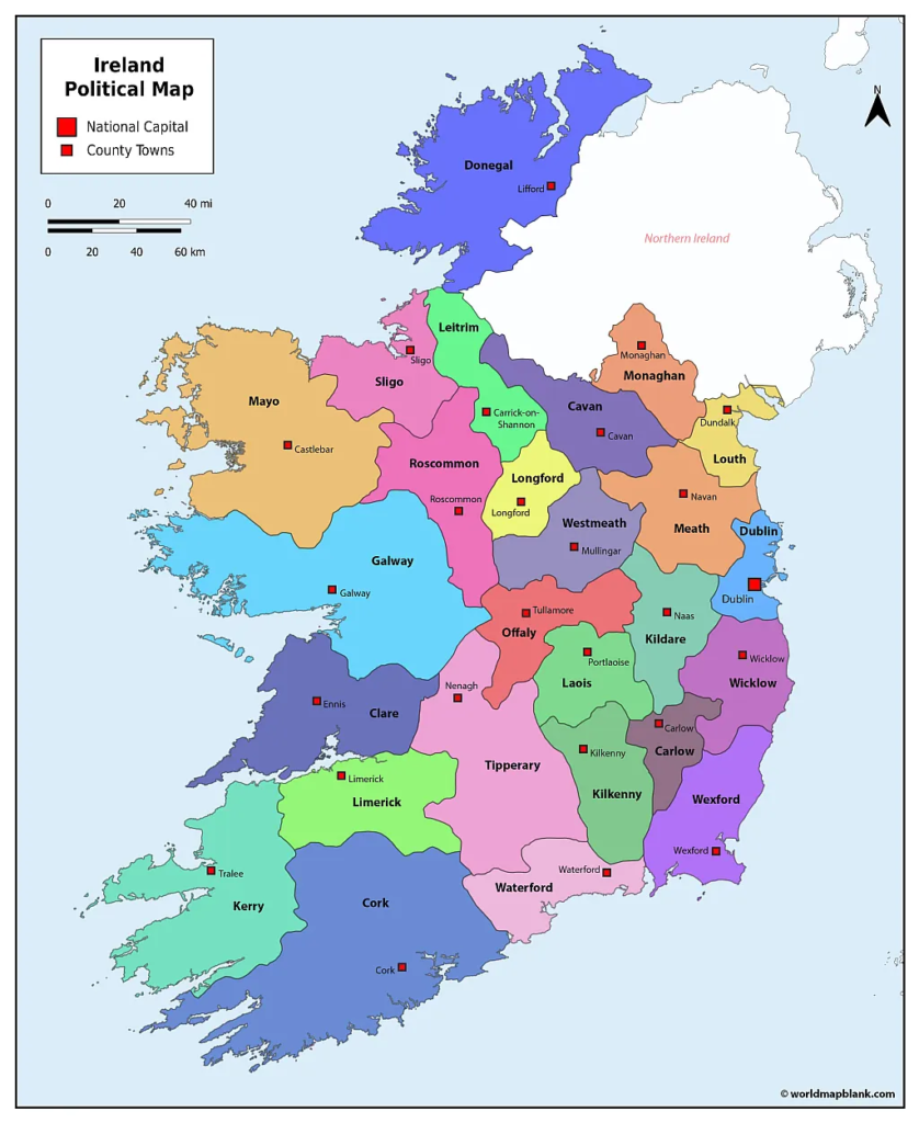
County Towns and Administrative Centers
| County | County Town / Administrative Center |
|---|---|
| Carlow | Carlow |
| Cavan | Cavan |
| Clare | Ennis |
| Cork | Cork |
| Donegal | Lifford |
| Dublin | Dublin |
| Galway | Galway |
| Kerry | Tralee |
| Kildare | Naas |
| Kilkenny | Kilkenny |
| Laois | Portlaoise |
| Leitrim | Carrick-on-Shannon |
| Limerick | Limerick |
| Longford | Longford |
| Louth | Dundalk |
| Mayo | Castlebar |
| Meath | Navan |
| Monaghan | Monaghan |
| Offaly | Tullamore |
| Roscommon | Roscommon |
| Sligo | Sligo |
| Tipperary | Clonmel and Nenagh |
| Waterford | Waterford |
| Westmeath | Mullingar |
| Wexford | Wexford |
| Wicklow | Wicklow |
Map: Ireland County Map with Towns / Administrative Centers
Ireland Map with Counties and Towns
An Ireland map with counties and towns is useful for understanding how settlements are distributed across the island and how towns relate to county boundaries.
Ireland is an island in the North Atlantic region of Europe. It is separated from Great Britain by bodies of water including the Irish Sea, North Channel, Celtic Sea, and St George’s Channel.
The island contains two political jurisdictions:
- Republic of Ireland — an independent sovereign state.
- Northern Ireland — part of the United Kingdom.
This distinction should be kept in mind when using a map that displays the entire island.
Our detailed map shows county boundaries, county towns, additional towns, and the boundary between the Republic of Ireland and Northern Ireland.
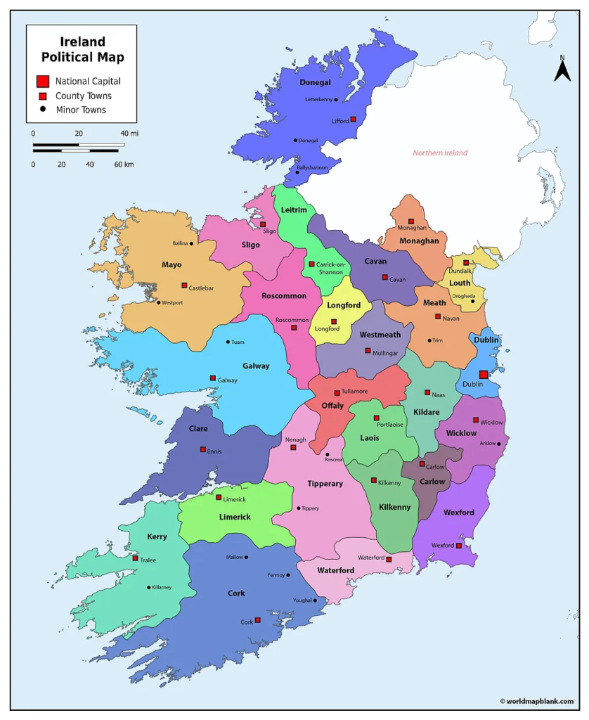
The map can be useful for:
- Geography lessons
- School assignments
- County identification
- Travel planning
- Classroom activities
- Ireland geography projects
- Printable reference material
Printable Ireland Map
A printable Ireland map is also useful when studying Ireland’s physical geography.
The River Shannon is Ireland’s longest river, flowing for approximately 360 km. Ireland is also known for its numerous lakes, many of which are called loughs.
Lough Corrib is the largest lake in the Republic of Ireland by surface area, according to Irish geographic references. The country’s landscape also includes extensive Atlantic coastline, mountains, rivers, lakes, lowlands, and agricultural areas.
Our general printable map does not focus on county boundaries. Instead, it shows useful geographic and transportation information including:
- Towns and settlements
- Major roads
- Railways
- Airports
- Geographic locations
- Northern Ireland and the Republic of Ireland
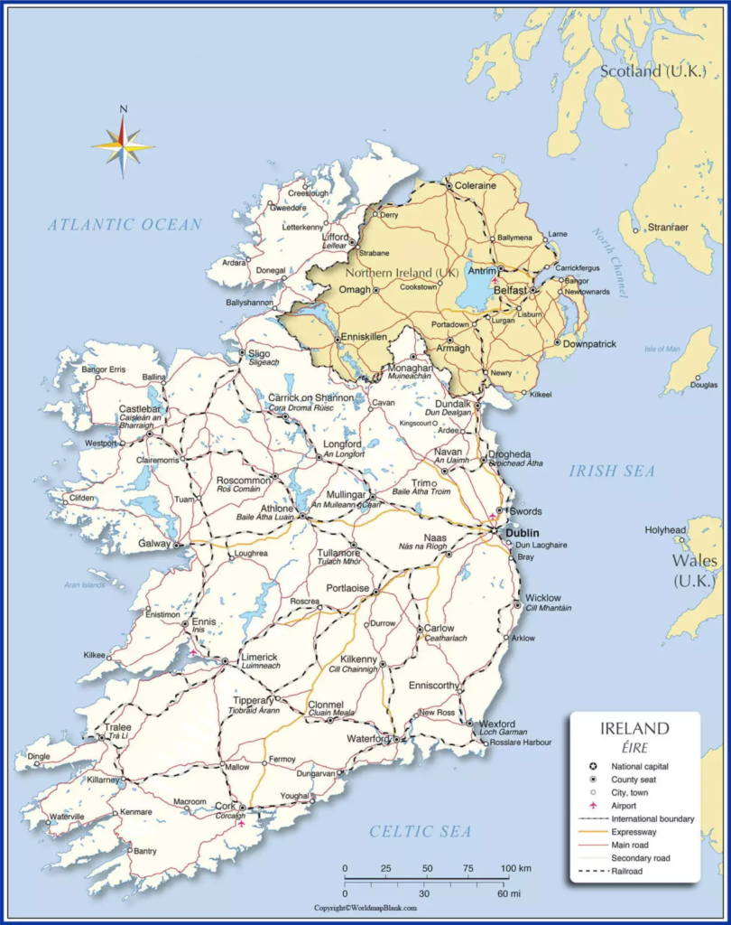
Ireland Map for Students and Teachers
A printable Ireland map can be used for a variety of educational activities.
Teachers can use county maps for:
- County identification exercises
- Geography quizzes
- Map-labeling activities
- Ireland geography lessons
- Classroom displays
- Homework assignments
Students can use blank or labeled maps to practice identifying counties, towns, provinces, cities, rivers, and other geographic features.
Four Provinces of Ireland
Ireland has four traditional provinces:
- Leinster
- Munster
- Connacht
- Ulster
The provinces are historically and culturally important but are not modern administrative governments. The provincial boundaries correspond with county boundaries, while only three of Ulster’s nine counties are within the Republic of Ireland.
This makes a province map particularly useful when studying the historical geography and cultural divisions of Ireland.
Ireland Geography Facts
Here are some useful facts that can make an Ireland map easier to understand:
- The island of Ireland contains 32 traditional counties.
- 26 counties are within the Republic of Ireland.
- Northern Ireland contains the remaining six traditional counties.
- Ireland has four traditional provinces: Leinster, Munster, Connacht, and Ulster.
- Dublin is divided into four local authority areas: Dublin City, Dún Laoghaire-Rathdown, Fingal, and South Dublin.
- The River Shannon is the longest river in Ireland.
- The Republic of Ireland’s official population statistics are produced by the Central Statistics Office.
- Ireland’s current statutory county boundary datasets are maintained through Ireland’s national geographic and mapping authorities.
Frequently Asked Questions About the Printable Ireland Map
How many counties are in the Republic of Ireland?
There are 26 counties in the Republic of Ireland. The island of Ireland has 32 traditional counties in total, with six located in Northern Ireland.
How many provinces are there in Ireland?
Ireland has four traditional provinces: Leinster, Munster, Connacht, and Ulster. They are important historical and cultural regions but do not operate as modern administrative governments.
Is Northern Ireland part of Ireland?
Northern Ireland is geographically located on the island of Ireland but is part of the United Kingdom. The Republic of Ireland is an independent sovereign state.
Can I print the Ireland map?
Yes. The maps on this page are provided in printable formats, including PDF versions designed for convenient printing.
Can I use an Ireland county map for school?
Yes. County maps are useful for geography lessons, classroom activities, assignments, quizzes, and map-labeling exercises.
What are the four provinces of Ireland?
The four provinces are Leinster, Munster, Connacht, and Ulster.
A county is a geographic and statutory division, while a local authority is the public body responsible for local government services in a particular administrative area. Ireland currently has 31 local authorities.
What is the capital of Ireland?
Dublin is the capital and largest city of the Republic of Ireland.
What is the longest river in Ireland?
The River Shannon is the longest river in Ireland.
What is the largest lake in the Republic of Ireland?
Lough Corrib is the largest lake in the Republic of Ireland by surface area.
Reference Links
https://data.gov.ie/dataset/counties-national-statutory-boundaries-ungeneralised-20261
https://data.gov.ie/dataset/provinces-national-statutory-boundaries-2019
More Free and Printable Maps of the World
Below we have compiled a collection of links to other interesting maps. If your desired map is not included, please use the search feature on top of this page. You can also leave a comment below, and we will try to create your map for you. All of our maps can be downloaded free of charge as PDF files.
Country Maps
- Outline Map of Ireland
- Blank Map of Italy
- France Map Outline
- Map of France with Regions
- Map of Australia with States
Continent Maps
- Blank Map of Asia
- Asia Mountains Map
- Printable Map of Europe
- Blank Map of Europe
- Blank Map of South America









