

A Labeled Map of Malaysia helps you identify the country’s states, federal territories, capital cities, major urban centres, and geographical regions. Located in Southeast Asia, Malaysia consists of two main regions: Peninsular Malaysia and East Malaysia, which are separated by the South China Sea.
Peninsular Malaysia occupies the southern part of the Malay Peninsula, while East Malaysia comprises Sabah and Sarawak on the island of Borneo. Malaysia shares land borders with Thailand, Indonesia, and Brunei, and Singapore lies just south of Peninsular Malaysia.
Whether you are a student, teacher, traveller, or geography enthusiast, these labeled maps can help you understand Malaysia’s administrative divisions and locate important cities.
- World map with continents
- Physical world map
- Political world map
- Labeled map of Asia
- Labeled map of Africa
- Labeled map of Europe
- Labeled map of South America
- World time zone map
- Labeled map of World
- Blank map of world
- Labeled map of North America
- Blank map of Asia
- World map with oceans
- World map poster
Labeled Map of Malaysia
Malaysia covers approximately 330,534 square kilometres, according to the Malaysian government’s location profile. The country is known for its tropical climate, diverse landscapes, coastal regions, and important waterways.
The South China Sea separates the country’s two principal geographical regions. Peninsular Malaysia borders Thailand to the north and is connected to Singapore by causeways and a bridge. East Malaysia occupies the northern part of Borneo and shares land borders with Indonesia and Brunei.
Some of Malaysia’s important rivers include the Rajang in Sarawak, the Kinabatangan in Sabah, the Pahang in Peninsular Malaysia, and the Perak River. These rivers are useful geographical reference points when studying the country’s physical landscape.
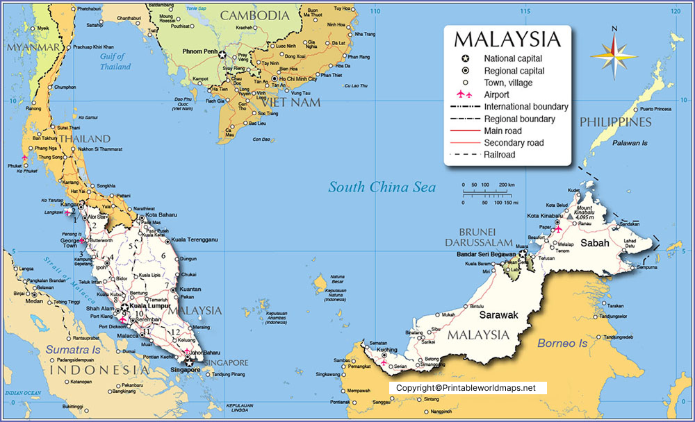
Labeled Map of Malaysia with States
Malaysia is a federation comprising 13 states and 3 federal territories. Eleven states are located in Peninsular Malaysia, while Sabah and Sarawak are located in East Malaysia.
The 13 states are:
- Johor
- Kedah
- Kelantan
- Melaka (Malacca)
- Negeri Sembilan
- Pahang
- Penang (Pulau Pinang)
- Perak
- Perlis
- Sabah
- Sarawak
- Selangor
- Terengganu
The three federal territories are Kuala Lumpur, Putrajaya, and Labuan. Unlike the states, federal territories are administered directly by the federal government.
Kuala Lumpur is Malaysia’s national capital, while Putrajaya serves as the federal administrative centre. This distinction is important when identifying the country’s capital and government institutions on a map.
A labeled states map is particularly useful for learning state boundaries, understanding regional locations, and preparing geography assignments.
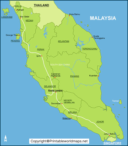
Labeled Map of Malaysia with Cities
Malaysia has several important cities and urban centres that serve as administrative, commercial, educational, industrial, and tourism hubs.
Some major cities and urban centres to locate on a labeled map include:
- Kuala Lumpur: The national capital and a major financial and commercial centre.
- George Town: The capital of Penang, known for its historic urban area and cultural heritage.
- Johor Bahru: A major urban centre in southern Peninsular Malaysia, near Singapore.
- Ipoh: The capital of Perak, known for its heritage architecture and surrounding limestone hills.
- Kota Kinabalu: The capital of Sabah and an important gateway to Malaysian Borneo.
- Kuching: The capital of Sarawak and a major centre in East Malaysia.
- Alor Setar: The capital of Kedah.
- Kuantan: The capital of Pahang and an important city on the east coast.
- Kota Bharu: The capital of Kelantan.
- Kuala Terengganu: The capital of Terengganu.
- Malacca City: The capital of Melaka and a well-known historical destination.
- Sandakan and Tawau: Important urban centres in Sabah.
City labels are useful for understanding where population centres are located in relation to state boundaries, coastlines, neighbouring countries, and transport routes.
Remember that a state’s capital is not always its largest or best-known city. Check the map legend and administrative labels when using a map for educational or research purposes.

Labeled Malaysia Map with Capital
Printable version: Use the map image above or create a downloadable PDF version if one is available for this specific map.
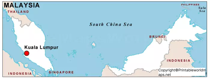
Kuala Lumpur is Malaysia’s national capital and the location of Parliament and many major national institutions. It is also one of the country’s most prominent commercial, cultural, and tourism centres.
Putrajaya, located south of Kuala Lumpur, is the federal administrative centre and houses many government ministries and offices. Although Putrajaya is important to Malaysia’s administration, it does not replace Kuala Lumpur as the national capital.
Kuala Lumpur lies in the Klang Valley, an urban region associated with the confluence of the Klang and Gombak rivers. The wider metropolitan area includes other important urban centres, including Petaling Jaya and Shah Alam.
When reading a capital map, distinguish between a national capital, a state capital, and a federal administrative centre. This helps avoid confusion when studying Malaysia’s political and administrative geography.
Geography of Peninsular Malaysia and East Malaysia
Malaysia’s geography is distinctive because its two main regions are separated by the South China Sea.
Peninsular Malaysia includes states such as Selangor, Johor, Perak, Pahang, Kedah, Kelantan, and Terengganu. It shares a land border with Thailand and lies north of Singapore.
East Malaysia comprises Sabah and Sarawak on Borneo. It borders Indonesia and Brunei and includes extensive forests, mountain ranges, river systems, and coastal areas.
The federal territory of Labuan is also located off the coast of Borneo. A map showing both Peninsular and East Malaysia is especially useful for understanding the country’s overall shape and regional separation.
How to Use a Labeled Map of Malaysia
A labeled map can support several practical learning activities:
- Identify all 13 states and the three federal territories.
- Locate Kuala Lumpur, Putrajaya, and the state capitals.
- Compare Peninsular Malaysia with East Malaysia.
- Identify neighbouring countries, coastlines, and the South China Sea.
- Practise locating major cities and rivers.
- Use a printable PDF for classroom activities, revision, or geography projects.
For the clearest results, choose a high-resolution map when printing and check whether state boundaries, city names, and the map legend remain readable at the selected paper size.
Frequently Asked Questions
1. How many states are there in Malaysia?
Malaysia has 13 states: 11 in Peninsular Malaysia and two in East Malaysia, namely Sabah and Sarawak.
2. How many federal territories does Malaysia have?
Malaysia has three federal territories: Kuala Lumpur, Putrajaya, and Labuan.
3. What is the capital of Malaysia?
Kuala Lumpur is Malaysia’s national capital. Putrajaya is the federal administrative centre.
4. What are the two main regions of Malaysia?
The two main regions are Peninsular Malaysia and East Malaysia. They are separated by the South China Sea.
Malaysia shares land borders with Thailand, Indonesia, and Brunei. Singapore lies immediately south of Peninsular Malaysia and is connected to it by road links.
6. What is the total area of Malaysia?
The Malaysian government’s location profile reports an area of approximately 330,534 square kilometres. Figures can differ slightly between sources because of measurement and reporting conventions.
7. Which are some of the major cities in Malaysia?
Major cities and urban centres include Kuala Lumpur, George Town, Johor Bahru, Ipoh, Kota Kinabalu, Kuching, Alor Setar, Kuantan, and Malacca City.
8. Can I download a printable map of Malaysia?
Yes. The PNG and PDF links provided in this article can be used to view or download the corresponding maps. Check the map’s labels and print quality before using it for assignments or presentations.
9. What is the difference between a state capital and the national capital?
The national capital is the country’s main capital city, while a state capital is the administrative centre of an individual state. Kuala Lumpur is Malaysia’s national capital, whereas cities such as Johor Bahru, Ipoh, and Kota Kinabalu are state capitals.
10. Where can I find official information about Malaysia’s geography and population?
The Malaysian government’s official portal provides geographical information, while the Department of Statistics Malaysia publishes population estimates and related statistical data. Consult these sources when you need current or authoritative figures.
Reference links
https://www.malaysia.gov.my/en/government/kenali-malaysia/lokasi
https://www.malaysia.travel/about-malaysia
https://www.dosm.gov.my/portal-main/release-content/current-population-estimates-2026
