
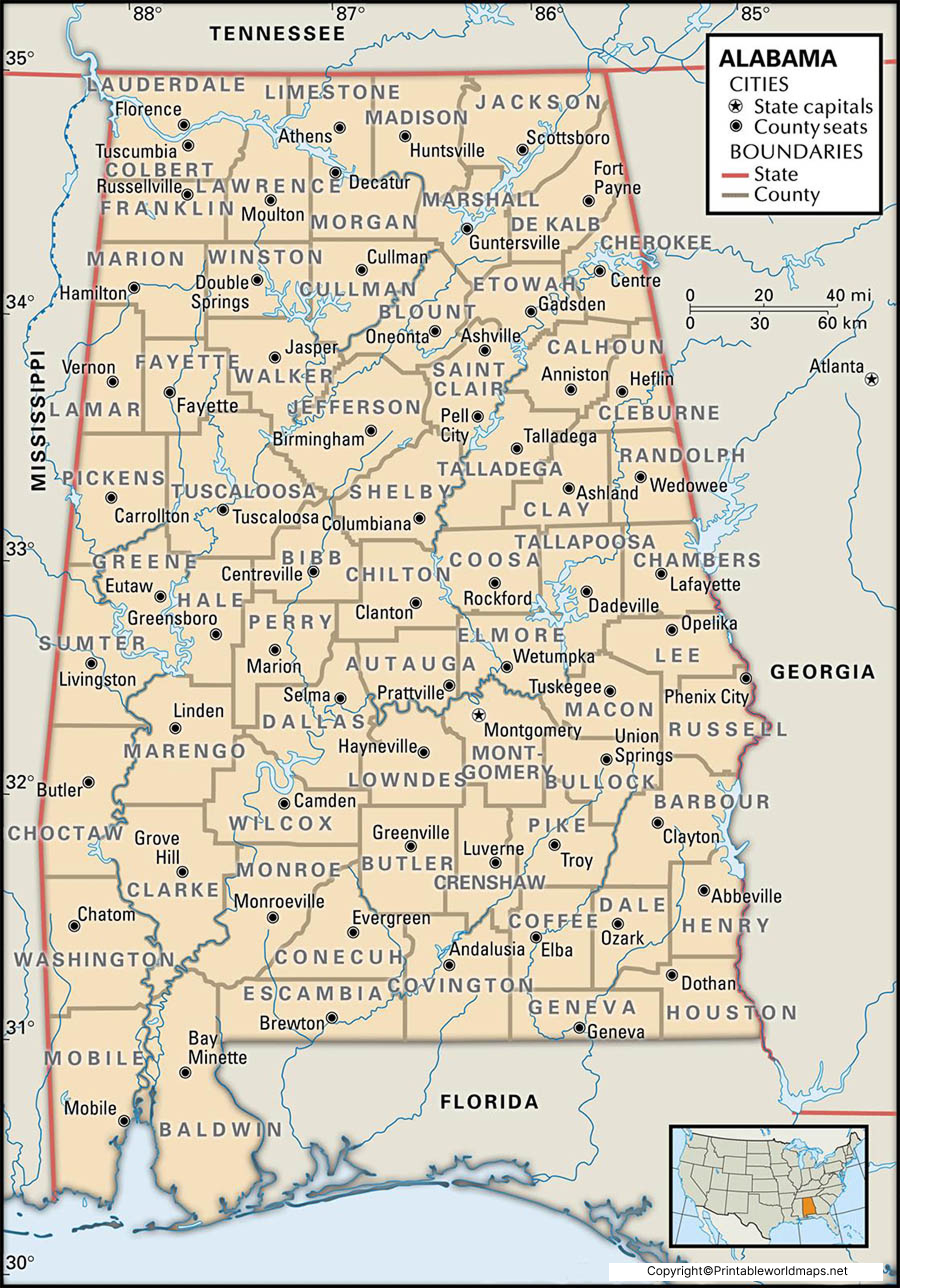
The Labeled Map of Alabama shows the location of Alabama in the southeastern United States, along with its capital, major cities, counties, rivers, highways, and other geographic features.
Alabama became the 22nd state of the United States on December 14, 1819. It is bordered by Tennessee to the north, Georgia to the east, Florida and the Gulf of Mexico to the south, and Mississippi to the west.
Montgomery is the state capital, while Huntsville, Birmingham, Mobile, and Montgomery are among Alabama’s major population centers.
This collection of labeled Alabama maps is useful for students, teachers, researchers, travelers, and anyone looking for a printable reference map of the state.
Labeled Map of Alabama
A labeled map of Alabama provides a geographic overview of the state and identifies important locations and physical features. Depending on the map, you can find Montgomery, Birmingham, Huntsville, Mobile, Tuscaloosa, major highways, rivers, lakes, and other populated places.
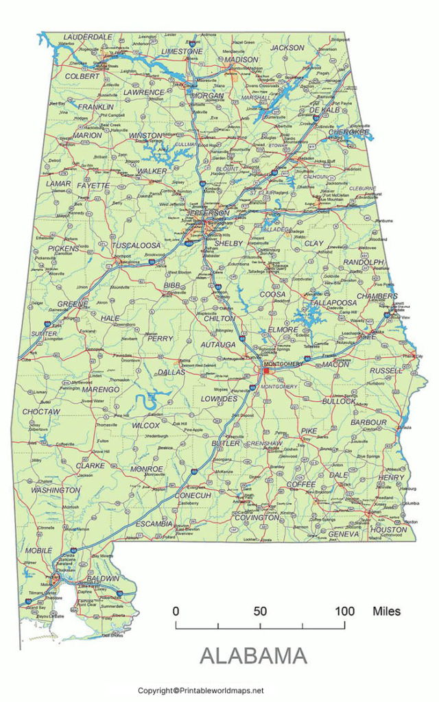
Alabama covers approximately 52,420 square miles (135,767 square kilometers), making it the 30th-largest U.S. state by total area.
The state has an important geographic connection to the Gulf of Mexico, with its southern coastline located in Mobile and Baldwin counties.
Alabama Geographic Facts
| Fact | Information |
|---|---|
| State | Alabama |
| Capital | Montgomery |
| Region | Southeastern United States |
| Statehood | December 14, 1819 |
| Statehood order | 22nd state |
| Largest city by population | Huntsville |
| Counties | 67 |
| Total area | About 52,420 sq mi |
| Major waterway | Tennessee River |
| Gulf coastline | Yes |
| Time zones | Central Time Zone |
The U.S. Census Bureau provides official geographic and demographic information for Alabama and its counties. U.S. Census Bureau – Alabama
Printable Alabama Map Labeled
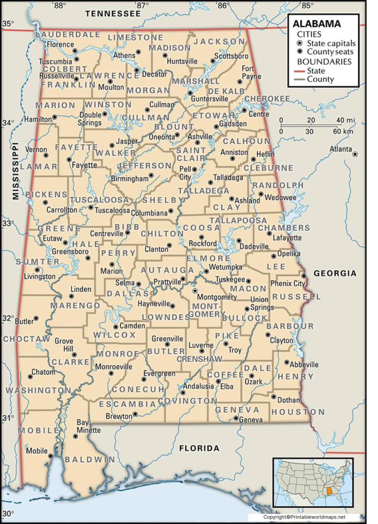
A printable Alabama map labeled with major locations can be useful for classroom activities, geography assignments, trip planning, and general referen
When printing the map, selecting a larger paper size or using the printer’s “fit to page” option can make city and geographic labels easier to read.
Labeled Map of Alabama with Cities
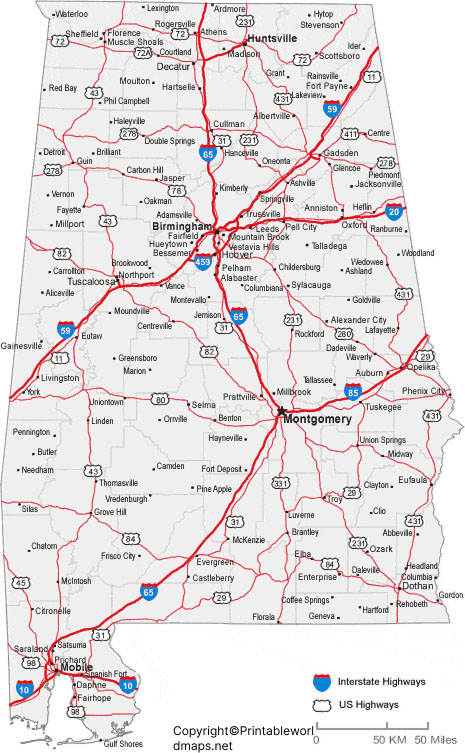
A labeled map of Alabama with cities makes it easier to locate major population centers throughout the state.
Some of Alabama’s best-known cities include:
- Huntsville — located in northern Alabama and home to a major aerospace and technology sector.
- Birmingham — an important metropolitan and commercial center in central Alabama.
- Montgomery — the state capital and a significant governmental center.
- Mobile — located near Mobile Bay on the Gulf Coast.
- Tuscaloosa — located in west-central Alabama and known as a major university city.
- Auburn — located in eastern Alabama and known for Auburn University.
- Dothan — located in southeastern Alabama and an important agricultural center.
Population figures change as new census estimates are released, so older population numbers should not be used as current figures without checking the latest Census Bureau data.
For current population information, consult the U.S. Census Bureau rather than relying on historical figures.
Labeled Alabama Map with Capital
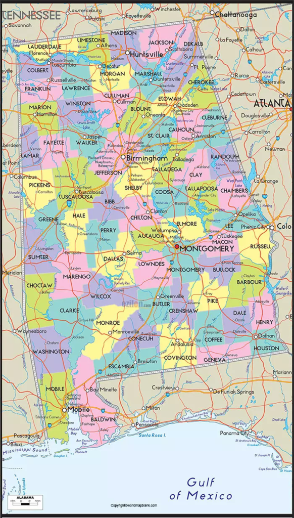
The Labeled Alabama Map with Capital identifies Montgomery as the capital of Alabama.
Montgomery is located in the central part of the state along the Alabama River. It became Alabama’s capital in 1846, replacing Tuscaloosa as the seat of state government.
Montgomery is also the county seat of Montgomery County and is an important center for Alabama’s state government and history.
Alabama Counties and Geographic Regions
Alabama is divided into 67 counties. A county map provides another useful way to understand the state’s administrative geography.
The state can also be broadly understood through geographic areas such as North Alabama, Central Alabama, the Black Belt, Wiregrass, and the Gulf Coast.
The landscape varies considerably across the state, from the Appalachian foothills in the north to coastal areas around Mobile Bay and the Gulf of Mexico.
Major Rivers and Water Features in Alabama
A detailed Labeled Map of Alabama can also help identify some of the state’s major rivers and waterways.
Important waterways include:
- Tennessee River
- Alabama River
- Tombigbee River
- Black Warrior River
- Coosa River
- Chattahoochee River
- Mobile Bay
- Gulf of Mexico
These waterways have played important roles in Alabama’s transportation, agriculture, industry, recreation, and settlement patterns.
Alabama Highways and Transportation
A Labeled Map of Alabama can be useful for classroom geography activities. Students can use it to identify:
- Alabama’s capital
- Major cities
- Neighboring states
- Counties
- Rivers and lakes
- Major highways
- Gulf Coast locations
- Geographic regions
Teachers can also use printable maps for labeling exercises, geography quizzes, state-history lessons, and classroom displays.
Why Use a Labeled Map of Alabama?
A labeled map makes geographic information easier to understand visually. Instead of locating places through a text-only list, users can see how cities, waterways, highways, and neighboring states relate spatially.
The maps on this page can be useful for:
- Students studying U.S. geography
- Teachers preparing classroom materials
- Travelers planning routes through Alabama
- Researchers looking for a geographic reference
- Families teaching children about U.S. states
- Map enthusiasts collecting printable state maps
Alabama Map: Quick Facts
| Category | Detail |
|---|
| State capital | Montgomery |
| Statehood | December 14, 1819 |
| State number | 22nd |
| Counties | 67 |
| Region | Southeastern United States |
| Northern border | Tennessee |
| Eastern border | Georgia |
| Western border | Mississippi |
| Southern border | Florida and Gulf of Mexico |
| Largest city by population | Huntsville |
| Major Gulf port | Mobile |
| Major interstate | I-65 |
| Total area | About 52,420 square miles |
Frequently Asked Questions About the Labeled Map of Alabama
What is the capital of Alabama?
Montgomery is the capital of Alabama. It is located in central Alabama along the Alabama River and serves as the seat of Alabama’s state government.
How many counties are in Alabama?
Alabama has 67 counties.
When did Alabama become a state?
Alabama became the 22nd state of the United States on December 14, 1819.
What states border Alabama?
Alabama borders Tennessee, Georgia, Florida, and Mississippi. It also has coastline along the Gulf of Mexico.
What is the largest city in Alabama?
Based on recent U.S. Census population estimates, Huntsville is Alabama’s largest city by population. Population rankings can change as new estimates are released.
What are the major cities shown on an Alabama map?
Major Alabama cities commonly shown on state maps include Huntsville, Birmingham, Montgomery, Mobile, Tuscaloosa, Auburn, and Dothan.
Does Alabama have a Gulf Coast?
Yes. Alabama has a Gulf Coast along the southern part of the state, including the Mobile Bay and Gulf Shores area.
Where can I download a printable Alabama map?
The printable maps on this page can be downloaded as PNG images and PDF files, making them suitable for classroom, educational, and reference use.
How many states border Alabama?
Four states border Alabama: Tennessee, Georgia, Florida, and Mississippi.
What is Alabama known for geographically?
Alabama contains diverse geographic areas, including the Appalachian foothills, forests, rivers, agricultural regions, the Black Belt, and the Gulf Coast.
Reference Links
https://www.census.gov/quickfacts/fact/table/AL/PST045225
https://www.outdooralabama.com









