

A Labeled Map of Jordan helps you locate the country’s capital, major cities, 12 governorates, neighboring countries, and important geographical features. Jordan, officially known as the Hashemite Kingdom of Jordan, is a country in the Middle East, in Western Asia. Its landscape includes desert regions, highlands, the Jordan Valley, and a short coastline on the Gulf of Aqaba.
Jordan shares land borders with Syria to the north, Iraq to the northeast, Saudi Arabia to the south and east, and Israel and the Palestinian territories to the west. The country is also known for historical and natural attractions such as Petra, the Dead Sea, Wadi Rum, and the Gulf of Aqaba.
This guide includes labeled maps of Jordan, a map showing its governorates, city locations, and the national capital. You can use these maps for school assignments, geography lessons, research, and general reference.
- World map with continents
- Physical world map
- Political world map
- Labeled map of Asia
- Labeled map of Africa
- Labeled map of Europe
- Labeled map of South America
- World time zone map
- Labeled map of world
- Blank map of world
- Labeled map of North America
- Blank map of Asia
- World map with oceans
- World map poster
Labeled Map of Jordan
The labeled map of Jordan helps readers identify the country’s location, capital, major settlements, and surrounding geography. It is useful for understanding how Jordan fits into the Middle East and how its urban areas are distributed across the country.
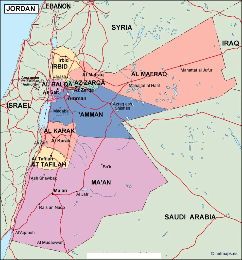
Jordan covers approximately 89,000 square kilometres of land and is largely characterized by arid and semi-arid environments. Its western region includes the Jordan Valley and the Dead Sea, while the eastern and southern parts contain extensive desert landscapes. Elevation varies considerably, from the Dead Sea shoreline, which lies below sea level, to higher plateaus and mountains.
The Jordan River forms part of Jordan’s western boundary. The Dead Sea, shared by Jordan, Israel, and the Palestinian territories, is one of the region’s most distinctive geographical features. In the south, Aqaba provides Jordan with access to the Red Sea through the Gulf of Aqaba.
Labeled Map of Jordan with States
Jordan is divided into 12 governorates, which are its principal administrative divisions. Although these divisions are sometimes informally called states or provinces, governorates is the correct administrative term.
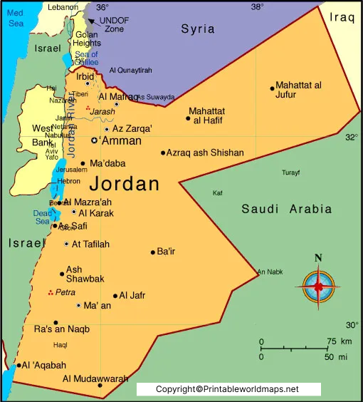
The 12 governorates of Jordan are:
- Amman
- Irbid
- Zarqa
- Balqa
- Madaba
- Karak
- Tafileh
- Ma’an
- Aqaba
- Mafraq
- Jerash
- Ajloun
Amman is the capital governorate and the country’s main political, administrative, and economic centre. Irbid is an important northern urban and educational centre, while Zarqa is a major industrial and population centre. Aqaba is strategically important because it provides Jordan’s only seaport and access to maritime trade.
Each governorate contains smaller administrative areas. The governorate map is therefore useful for understanding Jordan’s internal administrative geography, planning regional studies, and locating major towns.
Labeled Jordan Map with Cities
A labeled Jordan map with cities makes it easier to identify the country’s major urban centres and understand their geographical distribution. Population, urban development, and economic activity vary between the capital region, the northern cities, and the southern parts of the country.
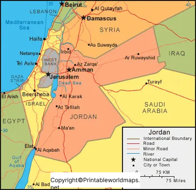
Important cities and urban centres include:
- Amman: Jordan’s capital and principal centre of government, commerce, education, and services.
- Irbid: A major city in northern Jordan known for universities, education, and regional commerce.
- Zarqa: An important industrial and urban centre northeast of Amman.
- Aqaba: A southern port city on the Gulf of Aqaba, important for shipping, tourism, and coastal activities.
- Madaba: Known for historical sites, archaeological heritage, and Byzantine-era mosaics.
- Jerash: Famous for its remarkably preserved Roman-era archaeological remains.
- Salt: A historic city west of Amman, known for its traditional architecture and cultural heritage.
- Karak: Known for its historic Crusader castle and surrounding highland landscapes.
- Ma’an: An important southern town and regional transport centre.
- Petra/Wadi Musa: Wadi Musa is the modern town serving visitors to Petra, the renowned archaeological site.
These locations have different roles in Jordan’s economy, history, education, transport, and tourism. When interpreting a city map, remember that city boundaries and population figures depend on the definition and census year used.
Labeled Jordan with Capital
Amman is the capital of Jordan. It is the country’s main administrative centre and one of its largest urban areas. The city is located in the northwestern part of Jordan, where hills and valleys shape its urban landscape.
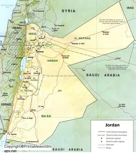
Amman combines modern commercial districts with historic neighbourhoods, archaeological remains, traditional markets, and cultural institutions. The city serves as the headquarters for national government institutions and many of the country’s major businesses and educational organisations.
Its location makes it a useful reference point when studying Jordan’s road network, population distribution, and connections with northern, central, and southern regions. The capital is also a common starting point for journeys to the Dead Sea, Jerash, Petra, and other destinations.
Geography and Location of Jordan
Jordan is located in Western Asia and is commonly included in the geographical region known as the Middle East. Its location places it at the intersection of routes connecting the Levant, the Arabian Peninsula, and neighbouring parts of Southwest Asia.
Key geographical features include:
- Jordan Valley: A low-lying area forming part of the Great Rift Valley system.
- Dead Sea: A hypersaline lake bordering Jordan to the west, with a shoreline far below global mean sea level.
- Gulf of Aqaba: The narrow gulf that gives Jordan access to the Red Sea.
- Eastern Desert: A large arid region covering much of eastern Jordan.
- Highlands: Elevated terrain running through parts of western Jordan and supporting several major settlements.
Jordan’s climate is generally dry, although conditions vary with elevation and location. The highlands tend to receive more rainfall than the eastern desert, and winters can be cool in elevated areas.
Interesting Facts About Jordan
Here are some useful facts to accompany the labeled map of Jordan:
- Official name: Hashemite Kingdom of Jordan.
- Capital: Amman.
- Administrative divisions: 12 governorates.
- Region: Middle East, Western Asia.
- Currency: Jordanian dinar (JOD).
- Official language: Arabic.
- Coastline: Jordan has a short coastline on the Gulf of Aqaba.
- Famous landmarks: Petra, the Dead Sea, Wadi Rum, Jerash, and the Gulf of Aqaba.
Petra is an internationally renowned archaeological site associated with the Nabataean civilisation. Wadi Rum is known for its dramatic sandstone landscapes, while the Dead Sea is notable for its unusually high salinity and low elevation. These landmarks provide useful geographical context beyond the administrative and city labels shown on a map.
How to Use a Labeled Map of Jordan
A labeled map of Jordan can be used for different educational and practical purposes:
- Geography assignments: Locate Jordan, its capital, governorates, neighbouring countries, and major physical features.
- School projects: Identify the 12 governorates and prepare regional geography notes.
- Travel planning: Understand the relative locations of Amman, Aqaba, Petra, Jerash, and the Dead Sea.
- Research and presentations: Use the map as a reference when discussing population distribution, transport, or regional development.
- Printable learning materials: Download the available PDF maps for offline study or classroom use.
For the clearest results, choose a map that matches your purpose. A political or administrative map is best for governorates and borders, while a city map is better for identifying settlements. A physical map is more appropriate for studying elevation, valleys, mountains, and desert regions.
Frequently Asked Questions
1. What is the capital of Jordan?
Amman is the capital of Jordan and the country’s principal political, administrative, commercial, and cultural centre.
2. How many governorates are there in Jordan?
Jordan has 12 governorates: Amman, Irbid, Zarqa, Balqa, Madaba, Karak, Tafileh, Ma’an, Aqaba, Mafraq, Jerash, and Ajloun.
3. Is Jordan divided into states or provinces?
Jordan is administratively divided into governorates. The term states is sometimes used informally in map searches, but governorates is the correct term for its principal administrative divisions.
4. Which countries border Jordan?
Jordan shares land borders with Syria, Iraq, Saudi Arabia, Israel, and the Palestinian territories. Its western boundary includes areas associated with the Jordan River and Dead Sea.
5. What are the major cities in Jordan?
Major urban centres include Amman, Irbid, Zarqa, Aqaba, and other cities such as Madaba, Salt, Karak, and Ma’an. Petra is a famous archaeological site accessed from the modern town of Wadi Musa.
6. Does Jordan have a coastline?
Yes. Jordan has a short coastline on the Gulf of Aqaba at the northern end of the Red Sea. Aqaba is the country’s principal coastal city and seaport.
7. Where can I download a labeled map of Jordan?
You can use the map links in this article to open labeled maps of Jordan, its governorates, cities, and capital. PDF versions are provided where available for printing and offline study.
8. What is Jordan famous for geographically?
Jordan is known for the Dead Sea, the Jordan Valley, desert landscapes, the Gulf of Aqaba, and highland terrain. The country also contains major historical and natural attractions, including Petra and Wadi Rum.
Reference links
https://dosweb.dos.gov.jo/
https://moi.gov.jo/
https://international.visitjordan.com/
https://www.britannica.com/place/Jordan
https://unstats.un.org/unsd/
https://whc.unesco.org/en/statesparties/jo/
