
The Labeled Map of Kazakhstan helps identify the country’s regions, capital, major cities, neighboring countries, and important geographic features. Kazakhstan, officially the Republic of Kazakhstan, is a country in Central Asia with a territory of about 2,724,900 square kilometers. Its capital is Astana.
Kazakhstan became independent from the Soviet Union on December 16, 1991. It borders Russia, China, Kyrgyzstan, Uzbekistan, and Turkmenistan and also has a coastline along the Caspian Sea.
The country is the world’s largest landlocked country by area and is notable for its vast steppe landscapes, deserts, mountains, and major inland water bodies.
Quick Kazakhstan Map Facts
| Fact | Information |
|---|---|
| Official name | Republic of Kazakhstan |
| Region | Central Asia |
| Capital | Astana |
| Area | 2,724,900 km² |
| Independence | December 16, 1991 |
| Currency | Kazakhstani tenge (KZT) |
| Administrative structure | 17 regions + 3 cities of republican significance |
| Population | 20,604,819 as of August 1, 2026 |
| Major cities | Almaty, Astana, Shymkent, Aktobe, Karaganda |
The latest available population release from Kazakhstan’s Bureau of National Statistics reports 20,604,819 people as of August 1, 2026.
- World map with continents
- Physical world map
- Political world map
- Labeled map of Asia
- Labeled map of Africa
- Labeled map of Europe
- Labeled map of South America
- World time zone map
- Labeled map of world
- Blank map of world
- Labeled map of North America
- Blank map of Asia
- World map with oceans
- World map poster
Labeled Map of Kazakhstan
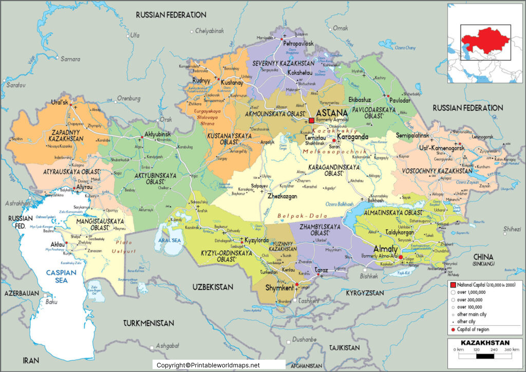
The Labeled Map of Kazakhstan is useful for identifying the country’s overall location, regional boundaries, capital, major cities, and surrounding countries. It can be used by students, teachers, travelers, researchers, and anyone studying Central Asian geography.
Kazakhstan stretches across a large area between Eastern Europe and Central Asia. The country includes extensive steppe regions as well as deserts, semi-deserts, mountain ranges, rivers, and lakes.
Labeled Map of Kazakhstan with States
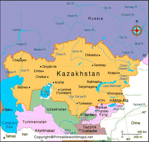
Kazakhstan’s current administrative structure is different from the 14-region structure mentioned in the original article. As of July 1, 2026, Kazakhstan has 17 regions, 195 districts, and 90 cities. Three cities—Astana, Almaty, and Shymkent—have republican significance.
17 Regions of Kazakhstan
The current regions are:
- Abay Region
- Akmola Region
- Aktobe Region
- Almaty Region
- Atyrau Region
- West Kazakhstan Region
- Zhambyl Region
- Zhetisu Region
- Karaganda Region
- Kostanay Region
- Kyzylorda Region
- Mangystau Region
- Pavlodar Region
- North Kazakhstan Region
- Turkistan Region
- Ulytau Region
- East Kazakhstan Region
These administrative divisions are based on Kazakhstan’s official statistical records for July 1, 2026.
Cities of Republican Significance
In addition to the 17 regions, Kazakhstan has three cities with republican significance:
- Astana — national capital
- Almaty — major economic and cultural center
- Shymkent — major city in southern Kazakhstan
Kazakhstan’s official statistics classify these three separately from the regions.
Labeled Kazakhstan Map with Cities
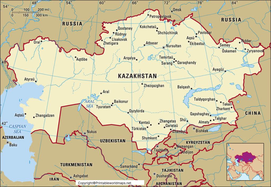
A Labeled Kazakhstan Map with Cities makes it easier to locate important urban centers across the country. Kazakhstan has 90 cities according to the latest administrative statistics available for July 1, 2026.
Important cities shown on Kazakhstan maps can include:
- Astana
- Almaty
- Shymkent
- Karaganda
- Aktobe
- Taraz
- Pavlodar
- Oskemen
- Semey
- Kostanay
- Kyzylorda
- Atyrau
- Aktau
- Petropavl
- Oral
- Turkistan
Almaty
Almaty is Kazakhstan’s largest city and an important economic, cultural, educational, and commercial center. It is located in southeastern Kazakhstan near the country’s mountainous border region.
Astana
Astana is the capital of Kazakhstan and one of the country’s principal administrative and political centers.
Shymkent
Shymkent is located in southern Kazakhstan and is one of the country’s three cities of republican significance.
Labeled Kazakhstan Map with Capital
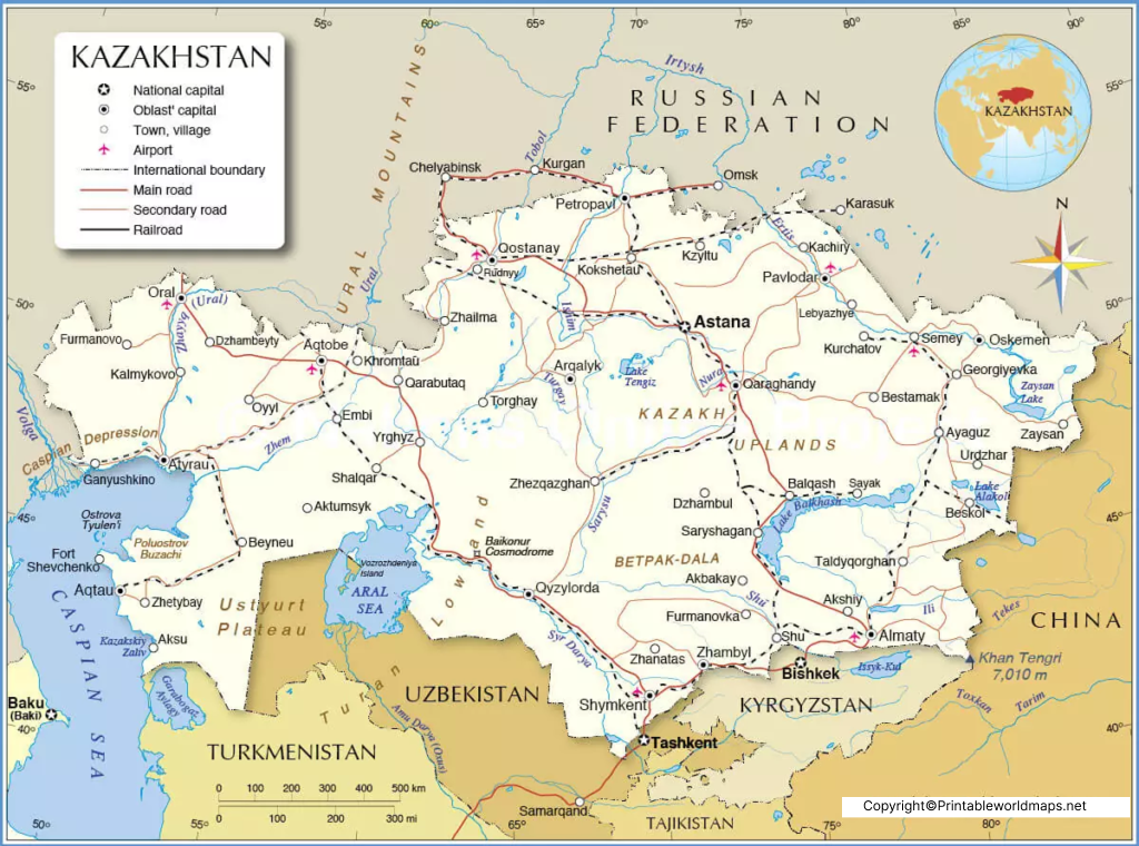
The capital of Kazakhstan is Astana. The city was officially renamed from Nur-Sultan back to Astana in September 2022.
Astana became Kazakhstan’s capital in 1997, after the capital was moved from Almaty. The city is located in the northern part of central Kazakhstan and has developed into an important political and administrative center.
The name history of the capital is useful when reading older maps:
- Akmolinsk — 1830–1961
- Tselinograd — 1961–1992
- Akmola — 1992–1998
- Astana — 1998–2019
- Nur-Sultan — 2019–2022
- Astana — 2022–present
The official 2022 presidential decree restored the name Astana.
Kazakhstan Geography and Location
Kazakhstan is located in Central Asia and has one of the largest land areas of any country in the world. Its territory covers approximately 2,724,900 km².
Countries Bordering Kazakhstan
Kazakhstan shares international borders with:
- Russia to the north and west
- China to the east
- Kyrgyzstan to the southeast
- Uzbekistan to the south
- Turkmenistan to the southwest
The Caspian Sea lies along Kazakhstan’s western side.
This geographic position makes Kazakhstan an important connection between Europe and Asia.
Major Physical Features on a Kazakhstan Map
A physical or labeled map of Kazakhstan can help identify several important geographic features, including:
- Caspian Sea
- Aral Sea
- Lake Balkhash
- Altai Mountains
- Tian Shan Mountains
- Kazakh Steppe
- Ural River
- Irtysh River
- Syr Darya
- Ili River
The country’s landscape ranges from low-lying Caspian areas and broad steppe landscapes to mountainous regions in the east and southeast.
Kazakhstan Map for Students and Teachers
A Labeled Map of Kazakhstan can be particularly useful for geography lessons and classroom activities.
Students can use the map to:
- Locate Kazakhstan in Central Asia
- Identify the capital, Astana
- Find the 17 regions
- Locate major cities
- Identify neighboring countries
- Study physical geography
- Compare Kazakhstan with other Central Asian countries
- Practice map-labeling exercises
Teachers can also use printable Kazakhstan maps for worksheets, geography quizzes, classroom presentations, and educational projects.
Interesting Facts About Kazakhstan
Here are several useful facts that can increase the educational value of the page:
- Kazakhstan is the world’s largest landlocked country by area.
- Kazakhstan became independent on December 16, 1991.
- The country’s capital is Astana.
- Kazakhstan covers approximately 2.725 million square kilometers.
- Kazakhstan currently has 17 regions.
- Astana, Almaty, and Shymkent are cities of republican significance.
- Kazakhstan had 90 cities as of July 1, 2026.
- Kazakhstan’s population was 20,604,819 on August 1, 2026.
- The country has coastlines along the Caspian Sea.
- Kazakhstan is one of the key geographic links between Europe and Asia.
Why Use a Labeled Map of Kazakhstan?
A labeled map provides geographic information in a visual format that can be easier to understand than a text-only description. It allows readers to quickly identify regional boundaries, cities, the capital, and Kazakhstan’s position within Central Asia.
For students, maps can support geography learning. For travelers and researchers, they provide a convenient overview of Kazakhstan’s major locations.
Frequently Asked Questions About the Labeled Map of Kazakhstan
What is the capital of Kazakhstan?
The capital of Kazakhstan is Astana. The city officially returned to the name Astana in September 2022.
How many regions are there in Kazakhstan?
Kazakhstan has 17 regions as of July 1, 2026. It also has three cities of republican significance: Astana, Almaty, and Shymkent.
What are the major cities in Kazakhstan?
Major cities include Astana, Almaty, Shymkent, Karaganda, Aktobe, Taraz, Pavlodar, Oskemen, Semey, Kostanay, Atyrau, Aktau, and Kyzylorda.
Is Kazakhstan in Europe or Asia?
Kazakhstan is generally classified as a Central Asian country. A small portion of its territory west of the Ural River is geographically considered part of Europe, depending on the geographic convention used.
Which countries border Kazakhstan?
Kazakhstan borders Russia, China, Kyrgyzstan, Uzbekistan, and Turkmenistan. It also borders the Caspian Sea.
What is the area of Kazakhstan?
Kazakhstan covers approximately 2,724,900 square kilometers.
What was Kazakhstan’s capital called before Astana?
The capital has had several historical names, including Akmolinsk, Tselinograd, Akmola, Astana, and Nur-Sultan. The official name is currently Astana.
How many cities are in Kazakhstan?
Kazakhstan had 90 cities as of July 1, 2026, according to the country’s Bureau of National Statistics.
What is Kazakhstan known for geographically?
Kazakhstan is known for its vast steppe, deserts, mountains, inland lakes, the Caspian Sea coastline, and its location between Europe and Asia.
Reference Links
https://stat.gov.kz/en/industries/social-statistics/demography/publications/513321
https://stat.gov.kz/ru/industries/social-statistics/demography
https://www.gov.kz/memleket/entities/mfa-prague/press/article/details/113246?lang=en
https://www.gov.kz/memleket/entities/mfa-pretoria/press/news/details/429981?lang=ru
https://www.gov.kz/memleket/entities/vko-altay-polyanskoe/press/events/details/29850









