
Labeled Map of Iran shows the country’s location, provinces, capitals, major cities, surrounding countries and important geographic features. Iran is located in southwestern Asia and has coastlines along the Caspian Sea to the north and the Persian Gulf and Gulf of Oman to the south. It has land borders with Armenia, Azerbaijan, Turkmenistan, Afghanistan, Pakistan, Turkey and Iraq.
Iran covers approximately 1,648,195 square kilometers. The World Bank reports a population of approximately 92.4 million in 2025, replacing the much older 2020 population figure previously used on this page.
The maps below are useful for students, teachers, researchers and anyone looking for a visual reference to Iran’s provinces, capitals and major cities.
- World map with continents
- Physical world map
- Political world map
- Labeled map of Asia
- Labeled map of Africa
- Labeled map of Europe
- Labeled map of South America
- World time zone map
- Labeled map of world
- Blank map of world
- Labeled map of North America
- Blank map of Asia
- World map with oceans
- World map poster
Labeled Map of Iran
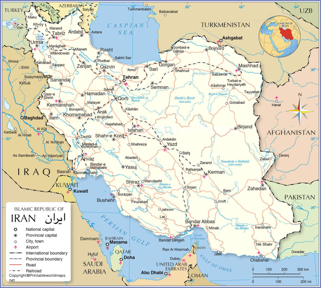
The Labeled Map of Iran provides a visual overview of the country’s location, boundaries and important geographic features. It can be used as a quick reference for geography lessons, classroom activities, map studies and general research.
Iran’s geography includes extensive mountain ranges, high plateaus, deserts and coastal areas. The country’s northern coastline borders the Caspian Sea, while its southern coastline extends along the Persian Gulf and Gulf of Oman.
Labeled Map of Iran with States
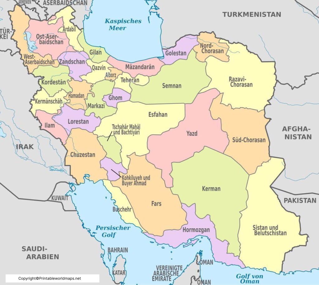
Iran is administratively divided into 31 provinces, each with its own provincial capital. The provinces are the primary administrative divisions shown on most political and administrative maps of Iran.
Iran also groups its 31 provinces into five administrative regions for coordination and regional administration. These regional groupings should not be confused with provinces because the provinces remain the principal administrative divisions.
Labeled Iran Map with Cities
The Five Administrative Regions of Iran
| Region | Regional Center |
|---|---|
| Region 1 | Tehran |
| Region 2 | Isfahan |
| Region 3 | Tabriz |
| Region 4 | Kermanshah |
| Region 5 | Mashhad |
These five regional groupings were established in 2014 based on geographical location, adjacency and similarities among provinces.
Labeled Iran Map with Cities
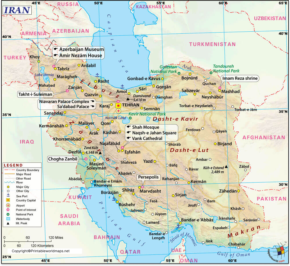
The Labeled Iran Map with Cities identifies important urban centers across the country. Cities commonly shown on Iran maps include Tehran, Mashhad, Isfahan, Shiraz, Tabriz, Karaj, Ahvaz, Qom, Kermanshah, Urmia, Rasht, Yazd, Kerman, Hamadan, Bandar Abbas, Zahedan, Arak, Qazvin and Sanandaj.
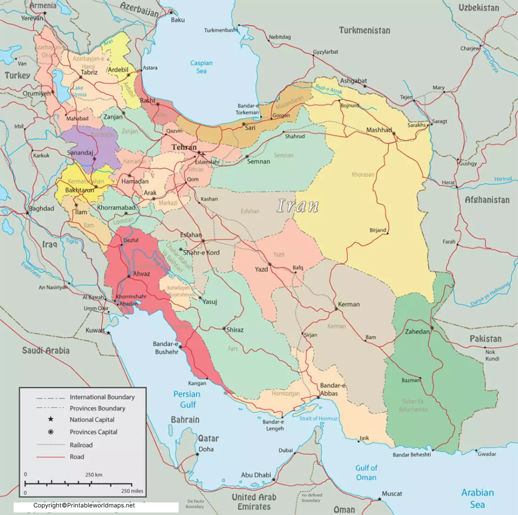
For geographic accuracy, it is useful to distinguish provincial capitals from other major cities. For example, Tehran is both the national capital and the capital of Tehran Province, while Mashhad is the capital of Razavi Khorasan Province.
Labeled Iran Map with Capital
Tehran is the capital city of Iran and is located in Tehran Province. It is the country’s principal political and administrative center.
One of Tehran’s most notable historic landmarks is Golestan Palace. UNESCO describes the palace as being in the historic core of Tehran and records its inscription on the World Heritage List in 2013. The complex is particularly associated with Qajar-era architecture and artistic production.
Other well-known landmarks in Tehran include Azadi Tower and major museums and cultural institutions.
Geography of Iran
Iran is situated in southwestern Asia and occupies a large area of approximately 1.65 million square kilometers. Its physical geography includes mountain ranges, elevated plateaus, deserts, plains and coastal environments.
Northern Iran
The northern part of the country borders the Caspian Sea. Mountainous terrain, including the Alborz range, is an important feature of northern Iran.
Southern Iran
Southern Iran reaches the Persian Gulf and Gulf of Oman, giving the country an important coastal zone.
Eastern Iran
Iran’s eastern land borders are with Afghanistan and Pakistan.
Western Iran
The western side of Iran borders Turkey and Iraq.
Northern Land Borders
Iran also has land borders with Armenia, Azerbaijan and Turkmenistan.
This makes a labeled map particularly useful for understanding Iran’s position in relation to the wider region.
Major Cities Shown on an Iran Map
Some of the most recognizable cities that may appear on a labeled map of Iran include:
- Tehran – National capital
- Mashhad – Capital of Razavi Khorasan
- Isfahan – Capital of Isfahan Province
- Shiraz – Capital of Fars Province
- Tabriz – Capital of East Azerbaijan
- Karaj – Capital of Alborz Province
- Ahvaz – Capital of Khuzestan
- Qom – Capital of Qom Province
- Kermanshah – Capital of Kermanshah Province
- Rasht – Capital of Gilan Province
- Yazd – Capital of Yazd Province
- Kerman – Capital of Kerman Province
- Urmia – Capital of West Azerbaijan
- Bandar Abbas – Capital of Hormozgan Province
- Zahedan – Capital of Sistan and Baluchestan
Interesting Facts About Iran
- Iran covers approximately 1,648,195 square kilometers.
- The country has 31 provinces.
- Tehran is the national capital.
- Iran borders the Caspian Sea in the north.
- The Persian Gulf and Gulf of Oman are located along its southern coastline.
- Iran has land borders with seven countries: Armenia, Azerbaijan, Turkmenistan, Afghanistan, Pakistan, Turkey and Iraq.
- The World Bank lists Iran’s population at approximately 92.4 million in 2025.
- Golestan Palace in Tehran has been a UNESCO World Heritage Site since 2013.
- UNESCO’s Iran country page currently lists 30 World Heritage properties, including Golestan Palace
How to Use the Printable Map of Iran
The printable maps can be useful for:
- Geography assignments
- Classroom activities
- Learning Iran’s provinces
- Identifying provincial capitals
- Studying neighboring countries
- Map-reading practice
- Educational presentations
- General geographic reference
For educational use, a labeled map can be paired with a blank map so students can practice identifying provinces, capitals, cities and surrounding geographic features.
Frequently Asked Questions
How many provinces are there in Iran?
Iran has 31 provinces. Each province has a provincial capital.
What is the capital of Iran?
Tehran is the capital of Iran.
What is the largest city in Iran?
Tehran is Iran’s largest city and national capital.
How many administrative regions does Iran have?
Iran’s 31 provinces are grouped into five administrative regions for regional coordination.
What are the five regional centers of Iran?
The regional centers are Tehran, Isfahan, Tabriz, Kermanshah and Mashhad.
Iran shares land borders with Armenia, Azerbaijan, Turkmenistan, Afghanistan, Pakistan, Turkey and Iraq.
Which seas and gulfs surround Iran?
Iran has a northern coastline along the Caspian Sea and southern coastlines along the Persian Gulf and Gulf of Oman.
Where is Tehran located?
Tehran is located in northern Iran and is the capital of both the country and Tehran Province.
What is Golestan Palace?
Golestan Palace is a historic palace complex in Tehran associated with the Qajar era. UNESCO inscribed it on the World Heritage List in 2013.
Is this map useful for students?
Yes. A labeled map can be used as a visual reference for learning Iran’s provinces, capitals, major cities, neighboring countries and physical geography.
Reference Links
https://data.worldbank.org/country/iran-islamic-rep
https://data.worldbank.org/indicator/SP.POP.TOTL?locations=IR
https://whc.unesco.org/en/statesparties/ir
https://whc.unesco.org/en/list/1422
https://unstats.un.org/unsd/geoinfo/ungegn/docs/3rd-uncsgn-docs/e_conf_69_4_EFS_agenda%207_9.pdf









