


The Labeled Map of Antigua and Barbuda helps you identify the country’s main islands, capital city, important settlements, and administrative divisions. Located in the eastern Caribbean, Antigua and Barbuda is an island nation in the Leeward Islands chain of the Lesser Antilles.
The country consists of two main inhabited islands, Antigua and Barbuda, along with several smaller islands, including uninhabited Redonda. Its national capital, St. John’s, is located on the island of Antigua, while Codrington is the principal settlement on Barbuda.
This guide includes labeled maps of Antigua and Barbuda with administrative divisions, cities, and the capital. You can also use the printable map PDFs for geography lessons, school projects, travel planning, and general reference.
- World map with continents
- Physical world map
- Political world map
- Labeled map of Asia
- Labeled map of Africa
- Labeled map of Europe
- Labeled map of South America
- World time zone map
- Labeled map of World
- Blank map of world
- Labeled map of North America
- Blank map of Asia
- World map with oceans
- World map poster
Labeled Map of Antigua and Barbuda
The labeled map of Antigua and Barbuda shows the country’s geographical position in the Caribbean and helps readers identify its main islands and significant locations.
Antigua and Barbuda covers approximately 442 square kilometers (171 square miles), according to international geographical references. Antigua is the larger and more populated island, while Barbuda lies to its north. Redonda, a small uninhabited island, is situated southwest of Antigua.
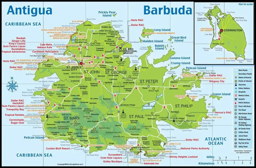
The country is known for its coastline, coral reefs, beaches, and varied landscapes. Antigua has a more developed network of settlements, while Barbuda is characterized by relatively flat terrain, coastal wetlands, and the Codrington Lagoon area.
Labeled Map of Antigua and Barbuda with States
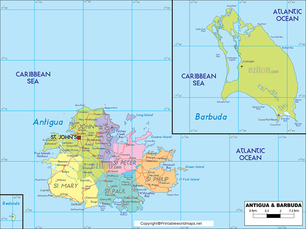
Antigua and Barbuda is an independent country, not a collection of states. Its administrative geography includes six parishes on Antigua, the dependency of Barbuda, and the dependency of Redonda. For geographical accuracy, the term parishes and dependencies is more appropriate than states.
The six parishes of Antigua are:
- Saint George
- Saint John
- Saint Mary
- Saint Paul
- Saint Peter
- Saint Philip
Barbuda and Redonda have distinct administrative status within the country. Barbuda has its own local council, while Redonda is uninhabited.
A map showing these divisions is useful for understanding the country’s administrative structure and the distribution of its communities.
Labeled Map of Antigua and Barbuda with Cities
The labeled map of Antigua and Barbuda with cities identifies important settlements across the two main islands. St. John’s is the national capital and the country’s principal urban centre. Other well-known settlements on Antigua include All Saints, Liberta, Parham, Bolans, and Swetes.
On Barbuda, Codrington is the principal settlement and administrative centre. These places differ in size and administrative importance, so not every settlement shown on a map should be described as a city.
The map can help students and readers understand where communities are located in relation to the islands’ coastlines and main transport routes.
Labeled Antigua and Barbuda Map with Capital
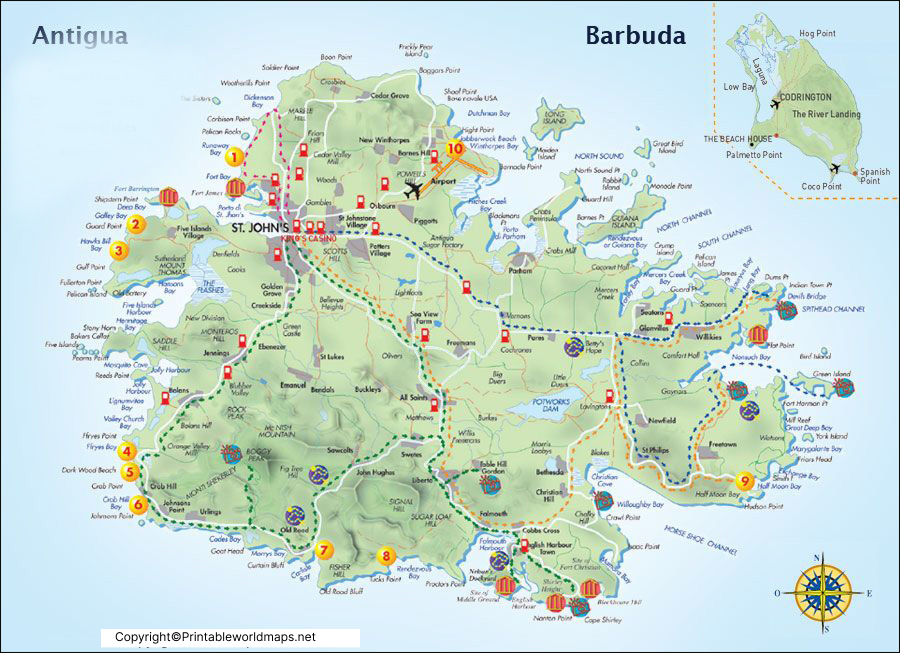
St. John’s is the capital of Antigua and Barbuda. It is located on the northwestern coast of Antigua and serves as the country’s main administrative, commercial, and port centre.
The city contains government offices, businesses, shops, historic buildings, and transport connections. St. John’s Harbour supports maritime activity, while V. C. Bird International Airport, located on Antigua, provides the country’s principal international air connection.
Codrington, located on Barbuda, is the island’s principal settlement. Showing both St. John’s and Codrington on a map helps readers distinguish the national capital from Barbuda’s main community.
Key Facts About Antigua and Barbuda
The following facts provide useful context when reading a labeled map of the country.
| Geographic detail | Information |
|---|---|
| Country | Antigua and Barbuda |
| Region | Eastern Caribbean |
| Island group | Leeward Islands, Lesser Antilles |
| National capital | St. John’s |
| Principal settlement on Barbuda | Codrington |
| Main islands | Antigua and Barbuda |
| Other notable island | Redonda, uninhabited |
| Total area | Approximately 442 km² |
| Official language | English |
| Currency | Eastern Caribbean dollar (XCD) |
| Administrative divisions | Six parishes on Antigua, plus Barbuda and Redonda as dependencies |
| Population | Approximately 94,209 in the World Bank’s 2025 estimate |
Population estimates vary by source and reference year. The figure above is a World Bank estimate, not a claim that the number represents a newly conducted census.
Geography and Landscape
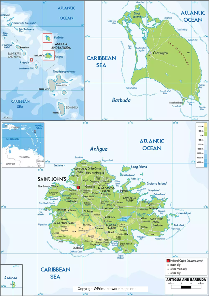
Antigua and Barbuda lies in the eastern Caribbean, where the Atlantic Ocean meets the Caribbean Sea region. The country’s position among the Leeward Islands makes it part of the northern island arc of the Lesser Antilles.
Antigua has a combination of low-lying coastal areas and higher terrain inland. Its highest point is commonly identified as Mount Obama, formerly known as Boggy Peak. Barbuda is much flatter and is known for its lagoon, beaches, and coastal habitats.
Redonda is a small, rocky, uninhabited island southwest of Antigua. Although it is not a major population centre, it is part of the country’s geographical and administrative picture.
The islands do not have a network of large permanent rivers comparable to that found in continental countries. Freshwater availability and water management are therefore important considerations for the islands.
Why Use a Labeled Map of Antigua and Barbuda?
A labeled map makes it easier to identify geographical features without having to look up each location separately. It is particularly useful for:
- Students and teachers: Learning the country’s islands, capital, settlements, and administrative divisions.
- Geography projects: Preparing school assignments, presentations, and Caribbean geography notes.
- Travel planning: Understanding the relative locations of St. John’s, Codrington, the airport, and other settlements.
- Research and reference: Identifying the country’s location within the Leeward Islands and the wider Caribbean.
- Printable study materials: Using a PDF map for classroom exercises, revision, or personal reference.
For school assignments, check that the map uses current geographical names and distinguishes parishes from dependencies. This avoids confusing the country’s administrative divisions with states.
How to Use and Print the Map
Follow these steps to use the map effectively:
- Choose the map that best fits your needs, such as the labeled country map, administrative map, city map, or capital map.
- Open the corresponding PDF download link.
- Check the map labels and legend before using it for study or research.
- Print the PDF using the page-size and orientation options appropriate for the map.
- If you are using the map in a report or presentation, credit the original map source and verify any facts that you add separately.
For digital use, make sure the map is readable on mobile devices. A clear image, descriptive alternative text, and a direct PDF link improve accessibility and usability.
Frequently Asked Questions
1. What is the capital of Antigua and Barbuda?
St. John’s, located on the island of Antigua, is the national capital of Antigua and Barbuda.
2. How many main islands make up Antigua and Barbuda?
The country has two main inhabited islands, Antigua and Barbuda. It also includes smaller islands, including Redonda, which is uninhabited.
3. Does Antigua and Barbuda have states?
No. Antigua and Barbuda does not have states like a federal country. Antigua is divided into six parishes, while Barbuda and Redonda are dependencies.
4. What is the principal settlement on Barbuda?
Codrington is the principal settlement and administrative centre on Barbuda.
5. What is the total area of Antigua and Barbuda?
The country’s total area is approximately 442 square kilometers, although published sources may differ slightly because of rounding and measurement conventions.
6. What language is spoken in Antigua and Barbuda?
English is the official language of Antigua and Barbuda.
7. Can I download a printable map of Antigua and Barbuda?
Yes. The map sections above provide PDF links for the labeled country map, administrative map, city map, and capital map. Open the relevant link to access the file.
8. Where is Antigua and Barbuda located?
Antigua and Barbuda is located in the eastern Caribbean in the Leeward Islands chain of the Lesser Antilles.
Reference links
https://gis.gov.ag/?page_id=130
https://www.ab.gov.ag/detail_template.php?page=aboutAB%2Fbarbuda
https://cip.gov.ag/about-antigua-barbuda/
https://www.paho.org/en/antigua-and-barbuda
https://fred.stlouisfed.org/series/POPTOTAGA647NWDB
https://unstats.un.org/unsd/publications/pocketbook/files/world-stats-pocketbook-2023.pdf
