

The Labeled Map of Afghanistan helps students, teachers, researchers, and geography enthusiasts identify the country’s 34 provinces, national capital, major cities, neighboring countries, and important geographical features. These printable maps are useful for school projects, geography lessons, presentations, and general reference.
Afghanistan is a landlocked country in Asia, known for its mountainous terrain and the Hindu Kush mountain range. Its location connects Central Asia with South Asia and places it near several important regional trade routes.
Explore the labeled maps below to understand Afghanistan’s provincial boundaries, locate Kabul, identify major urban centers, and learn more about the country’s physical geography.
- World map with continents
- Physical world map
- Political world map
- Labeled map of Asia
- Labeled map of Africa
- Labeled map of Europe
- Labeled map of South America
- World time zone map
- Labeled map of World
- Blank map of world
- Labeled map of North America
- Blank map of Asia
- World map with oceans
- World map poster
Labeled Map of Afghanistan
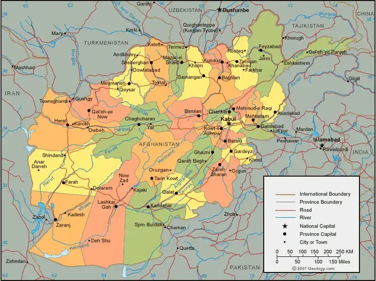
The labeled map of Afghanistan provides a geographical overview of the country, including its location, international boundaries, cities, and selected physical features. Depending on the map version, it may also show major roads, rivers, airports, and transport routes.
Afghanistan covers approximately 652,230 square kilometers and is a landlocked country. Its terrain includes high mountains, valleys, plateaus, and dry lowland areas. The Hindu Kush mountain range is one of its most prominent physical features.
Afghanistan shares internationally recognized land borders with six countries: Pakistan, Iran, Turkmenistan, Uzbekistan, Tajikistan, and China. These neighboring countries make Afghanistan an important geographical link between several parts of Asia.
The Amu Darya forms part of Afghanistan’s northern boundary, while the Helmand River is an important river system in the country’s southwest. The Kabul River is another significant river associated with the country’s capital region.
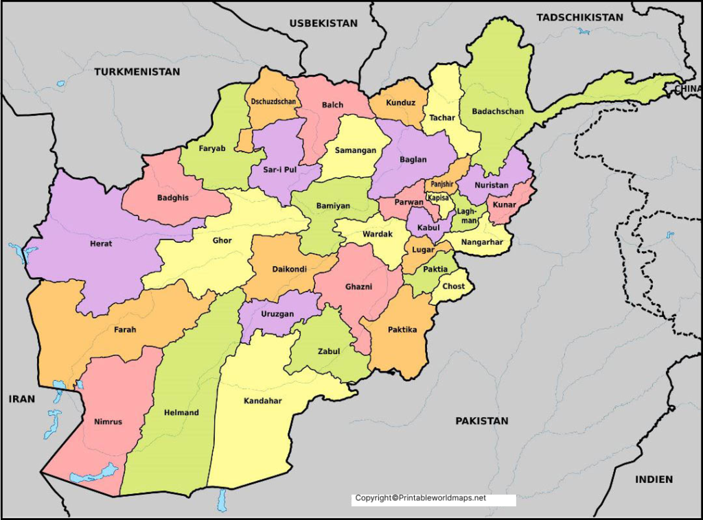
Labeled Map of Afghanistan with States
Afghanistan is divided into 34 provinces, which are its primary administrative divisions. A labeled provincial map helps readers understand where each province is located and how the country is organized geographically.
The 34 provinces are:
- Badakhshan
- Badghis
- Baghlan
- Balkh
- Bamyan
- Daykundi
- Farah
- Faryab
- Ghazni
- Ghor
- Helmand
- Herat
- Jowzjan
- Kabul
- Kandahar
- Kapisa
- Khost
- Kunar
- Kunduz
- Laghman
- Logar
- Nangarhar
- Nimroz
- Nuristan
- Paktika
- Paktiya
- Panjshir
- Parwan
- Samangan
- Sar-e Pol
- Takhar
- Uruzgan
- Wardak
- Zabul
Provincial maps are especially useful for identifying administrative boundaries, comparing the locations of provinces, and learning the relationship between provincial centers and the national capital. Spellings can vary slightly between maps and reference sources because Afghan place names are transliterated from local languages.
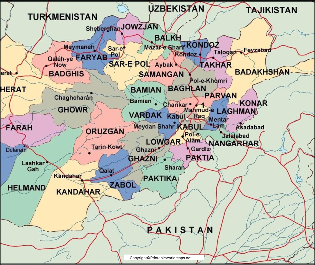
Labeled Map of Afghanistan with Cities
A labeled city map helps readers locate Afghanistan’s major urban centers and understand their geographical distribution. Important cities include Kabul, Kandahar, Herat, Mazar-i-Sharif, Jalalabad, Kunduz, Ghazni, and Lashkar Gah.
Kabul is the national capital and a major administrative, economic, and population center. Kandahar is an important city in the south, while Herat lies in western Afghanistan near the Iranian border. Mazar-i-Sharif is a major urban center in the north, and Jalalabad is located in the east near the route toward Pakistan.
These cities have different regional roles, making them useful reference points when studying Afghanistan’s geography, transportation connections, and settlement patterns.
A city map can help students identify urban locations in relation to provincial boundaries, neighboring countries, mountain ranges, and major rivers.
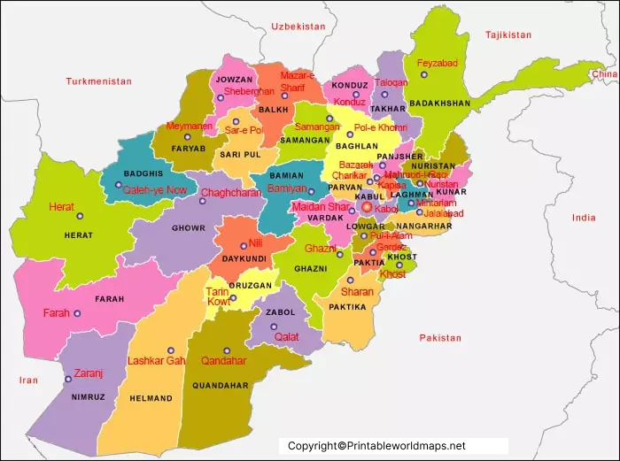
Labeled Afghanistan with Capital
The capital city of Afghanistan is Kabul, located in the eastern part of the country in a mountainous valley. Kabul serves as a major center for administration, commerce, education, and transportation.
A labeled map showing Afghanistan’s capital makes it easier to distinguish the national capital from provincial centers and other major cities. It also helps readers understand Kabul’s position in relation to nearby provinces and the surrounding mountain terrain.
Kabul is associated with the Kabul River and lies along important regional routes connecting different parts of Afghanistan.
Geography of Afghanistan: Important Facts
The following facts provide additional context for understanding Afghanistan’s location and physical geography.
- Location: Afghanistan is a landlocked country in Asia, commonly associated with both Central Asia and South Asia.
- Capital: Kabul.
- Administrative divisions: 34 provinces.
- Total area: Approximately 652,230 square kilometers.
- Neighboring countries: Pakistan, Iran, Turkmenistan, Uzbekistan, Tajikistan, and China.
- Major mountain range: The Hindu Kush.
- Important rivers: The Amu Darya, Helmand, and Kabul rivers.
- Terrain: Mountains, valleys, plateaus, and arid or semiarid regions.
- These facts are useful when interpreting political, administrative, and physical maps of Afghanistan. Population figures and demographic estimates can change over time, so consult a dated and reputable source when current statistics are required.
How to Use a Printable Afghanistan Map
Printable maps can support several educational and research activities:
- School assignments: Label provinces, cities, the capital, and neighboring countries.
- Geography practice: Identify Afghanistan’s location and surrounding regions.
- Classroom learning: Compare administrative maps with physical maps.
- Research and presentations: Use provincial and city boundaries as geographical references.
- Map-labeling exercises: Print a blank map and add place names from a separate reference map.
For the clearest results, choose a high-resolution image or PDF. Check the map legend, date, labels, and source before using it for research or formal educational materials.
Frequently Asked Questions
1. What does a labeled map of Afghanistan show?
A labeled map of Afghanistan can show the country’s provinces, capital, major cities, international borders, and selected geographical features. The exact details depend on the map.
2. How many provinces does Afghanistan have?
Afghanistan has 34 provinces, which are its primary administrative divisions.
3. What is the capital of Afghanistan?
Kabul is the capital of Afghanistan. It is located in the eastern part of the country.
4. Which countries border Afghanistan?
Afghanistan shares land borders with Pakistan, Iran, Turkmenistan, Uzbekistan, Tajikistan, and China.
5. What are the major cities of Afghanistan?
Major cities include Kabul, Kandahar, Herat, Mazar-i-Sharif, Jalalabad, Kunduz, Ghazni, and Lashkar Gah.
6. What is the largest mountain range in Afghanistan?
The Hindu Kush is the country’s principal mountain range and a major feature of its physical geography.
7. Can I print the labeled map of Afghanistan?
Yes. The image and PDF resources provided in this article can be used to view or print the corresponding maps. Check the terms of use if you plan to redistribute or republish them.
8. What is the difference between a political map and a physical map of Afghanistan?
A political map emphasizes boundaries, provinces, cities, and administrative locations. A physical map focuses on natural features such as mountains, valleys, rivers, and elevation.
Reference links
https://www.un.org/geospatial/content/afghanistan
https://www.cia.gov/the-world-factbook/countries/afghanistan
