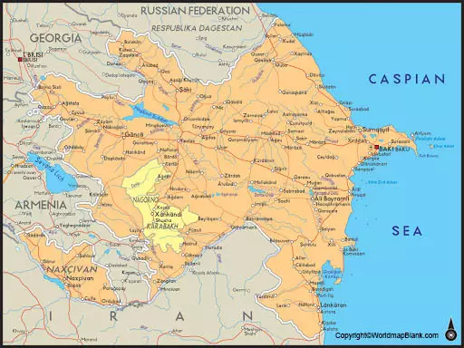
The Azerbaijan Labeled Map shows that it is a republic country, located in the regions of Western Asia and southeastern Europe. Azerbaijan situates in the Caucasus or Transcaucasia, and on the western shore region of the Caspian Sea. Besides, the country is located at the crossroads of Western Asia as well as the Eastern part of Europe. Countries like Turkey, Russia, Iran, Georgia, and Armenia, border Azerbaijan.
- World map with continents
- Physical world map
- Political world map
- Labeled map of Asia
- Labeled map of Africa
- Labeled map of Europe
- Labeled map of Antarctica
- Labeled map of South America
- World time zone map
- Labeled map of World
- World map with Latitude
- Blank map of world
- Labeled map of North America
- Blank map of Asia
- World map with oceans
- World map poster
Contents
Labeled Map of Azerbaijan
The official name was declared as the Republic of Azerbaijan when the former Soviet republic gained independence in 1991. The country occupies an area of 86,600 square kilometers or 33 774 square miles. In this area, places like Nakhichevan and Nagorno-Karabakh is include. The latest updated population of Azerbaijan is equivalent to 10,141,758 as on Sunday, July twelfth of 2020. This population is equivalent to 0.13% of the total global population.
The rivers that flow in this country categorize into three groups. In the first group, the rivers are known as, Kur Basin rivers. There are eight rivers in this group. The second group of rivers are known as, Aras basin rivers. There are five rivers in this group. The third group of rivers consists of rivers that flow directly into the Caspian Sea. Here, there are five rivers. The major religion in Azerbaijan is Islam. More than three-fifths of the population follow Shii religion whereas one third follows Sunni religion. A small percentage of the population follows the Christian religion through Armenian Orthodox Church.

Labeled Map of Azerbaijan with States
As a part of the labeled map of Azerbaijan with states, the country has 77 city provinces or states, which include twelve federal level city provinces or states, sixty-four smaller rayon class city provinces or states, and one special legal status city province or state. Administratively, the country is divide into fifty-nine districts.

Labeled Map of Azerbaijan with Cities
As a part of labeled map of Azerbaijan with Cities, the five biggest cities in Azerbaijan, include Baku, the capital city of the country, Ganja, Sumqayit, Lankaran and Mingachevir. Language spoken is Azerbaijani.

Labeled Azerbaijan with Capital
Through the labeled Azerbaijan with Capital, in 1920, Baku became the capital city of the Republic of Azerbaijan. This consists of the old fortress of Icheri-Shekher. It is on the western shore of the Caspian Sea, and on the southern side of Asbseron Peninsula, surrounding the broad curving sweep of the Bay of Baku.

Islands of Baku Archipelago Shelter the Bay. It provides the best harbor of the Caspian. Abşeron Peninsula provides adequate protection from the northerly winds that blow violently on the city. Its name is derived owing to the importance of oil industry development and administrative functions. Baku is the commercial hub of Azerbaijan with a low-lying coastline. It contains the iconic stone Maiden Tower, a vast royal complex known as, the Palace of the Shirvanshahs. Other contemporary landmarks include three-pointed skyscrapers covered with LED screens, the Flame Towers, and the Zaha Hadid–designed Heydar Aliyev Center.


