

The Labeled Map of Angola helps you locate the country’s provinces, capital city, major urban centres, neighbouring countries, and important geographical features. Angola is a country on the western coast of south-central Africa, bordered by the Atlantic Ocean to the west, Namibia to the south, Zambia to the east, and the Democratic Republic of the Congo to the north and northeast. A small part of its territory, Cabinda, is separated from the rest of the country by the Democratic Republic of the Congo.
Angola covers approximately 1,246,700 square kilometres. Its capital is Luanda, a major coastal city and an important centre for government, commerce, transport, and industry. The country’s official language is Portuguese, and the national currency is the Angolan kwanza.
Use the labeled maps below to identify Angola’s administrative divisions, provincial capitals, cities, and geographical location. The printable PDF versions can be useful for classroom activities, geography assignments, presentations, and personal reference.
- World map with continents
- Physical world map
- Political world map
- Labeled map of Asia
- Labeled map of Africa
- Labeled map of Europe
- Labeled map of South America
- World time zone map
- Labeled map of World
- Blank map of world
- Labeled map of North America
- Blank map of Asia
- World map with oceans
- World map poster
Labeled Map of Angola
The labeled map of Angola provides a geographical overview of the country and helps readers understand its location in Africa. Angola has a long Atlantic coastline, a varied interior landscape, and international borders connecting it with four neighbouring countries.
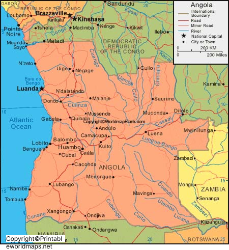
Angola’s landscape includes a coastal plain, elevated interior plateaus, river valleys, and drier regions in the south. The Cuanza River, also written as Kwanza, is one of the country’s important rivers and flows towards the Atlantic Ocean. The Cubango River forms part of the wider Okavango River system, which continues towards Botswana.
The country’s geographical position makes it an important part of the Atlantic coast of Africa. Its climate varies by region, with coastal and southern areas generally drier than many northern areas.
Labeled Map of Angola with States
Angola is administratively divided into 21 provinces, rather than the 18 provinces shown in older maps. The updated administrative division was established under Law No. 14/24 of 5 September 2024, with implementation arrangements introduced as the new structures were organised.
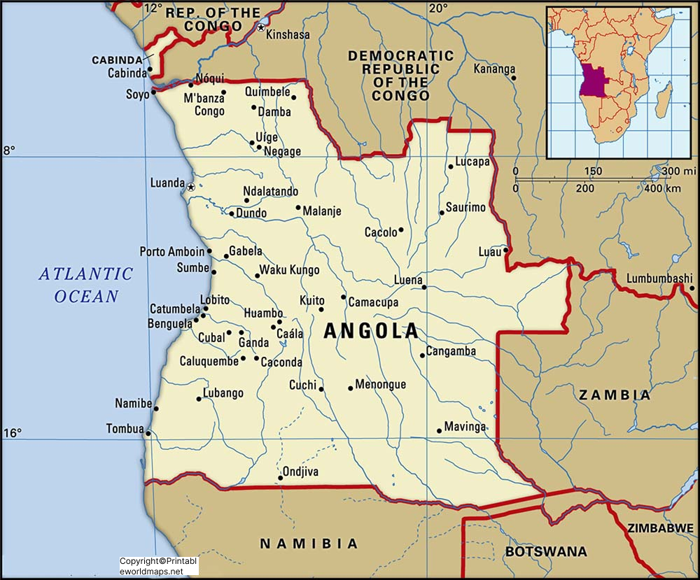
The 21 provinces are:
- Bengo
- Benguela
- Bié
- Cabinda
- Cuando
- Cubango
- Cuanza Norte
- Cuanza Sul
- Cunene
- Huambo
- Huíla
- Icolo e Bengo
- Luanda
- Lunda Norte
- Lunda Sul
- Malanje
- Moxico
- Moxico Leste
- Namibe
- Uíge
- Zaire
The new administrative arrangement includes the provinces of Cuando, Cubango, Icolo e Bengo, and Moxico Leste. These changes resulted from the reorganisation of the former Cuando Cubango, Luanda, and Moxico provinces.
Labeled Map of Angola with Cities
A labeled map of Angola with cities helps readers identify important urban centres and understand their locations in relation to the country’s coastline, interior, and provincial boundaries. It is especially useful for students, teachers, travellers, and anyone studying African geography.

Some notable cities and urban centres in Angola include:
- Luanda: The national capital and a major commercial and transport hub.
- Huambo: An important city in the central highlands.
- Lobito: A coastal port city in Benguela Province.
- Benguela: A historic coastal city and regional commercial centre.
- Lubango: A major urban centre in Huíla Province.
- Malanje: An important city in northern-central Angola.
- Uíge: A city in the north of the country.
- Cabinda: The principal city of the Cabinda exclave.
- Saurimo: The capital of Lunda Sul Province.
- Cuito: The capital of Bié Province.
City populations vary by year and by whether the figures refer to municipal boundaries, urban areas, or metropolitan areas. For that reason, population rankings should be accompanied by a dated, clearly identified source rather than relying on undated city counts.
Labeled Map of Angola with Capital
Luanda is the capital of Angola and is located on the country’s Atlantic coast. It is the seat of national government and one of the country’s principal centres for business, industry, shipping, and international connections.
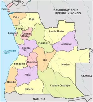
Luanda has a major seaport and plays an important role in Angola’s economy. Economic activities associated with the city and its surrounding region include trade, transport, construction, services, manufacturing, and industries connected with the country’s petroleum sector.
Luanda is also the capital of Luanda Province. However, under Angola’s updated administrative division, the provincial seat is the municipality of Ingombota, while the capital of the country remains Luanda. Icolo e Bengo is now a separate province.
Angola’s Location and Neighbouring Countries
Angola is located on the western side of south-central Africa. Its position along the Atlantic Ocean provides access to maritime trade, while its land borders connect it to Central and Southern Africa.
The country’s neighbours are:
- Democratic Republic of the Congo: To the north and northeast, and also adjacent to Cabinda.
- Republic of the Congo: Along the northern boundary of Cabinda.
- Zambia: To the east.
- Namibia: To the south.
The Atlantic Ocean lies to the west. Cabinda is geographically separated from the main part of Angola, making it an important feature to recognise when studying the country’s political map.
Physical Geography of Angola
Angola has varied physical geography, including coastal lowlands, interior plateaus, highlands, river basins, and relatively dry areas in the south. The highest parts of the country are found in the central highlands.
Important geographical features include the Cuanza River, the Cubango River system, the Atlantic coastline, and the highland areas around Huambo and Huíla. These features influence settlement, transport, agriculture, and regional economic activity.
The climate is not uniform across the country. The north generally receives more rainfall, while the coast and south include areas with drier conditions. Seasonal rainfall also influences river levels and agricultural activities.
How to Use and Print the Angola Maps
The printable Angola maps can be used for school projects, geography lessons, revision, presentations, and general reference.
- Open the map image or PDF link provided in the relevant section.
- Check whether the map shows country borders, provinces, cities, or the capital.
- For a printed copy, select a suitable paper size and use the print settings that preserve map labels and boundaries.
- If you are using the map for current administrative research, compare its province boundaries and names with an official government source.
- For school assignments, add the map’s source and access date where required.
A blank outline map can also be useful for practising province names, identifying neighbouring countries, and marking the capital and major cities.
Frequently Asked Questions About Angola Maps
1. What is the capital of Angola?
Luanda is the capital of Angola. It is situated on the Atlantic coast and serves as the country’s national administrative and economic centre.
2. How many provinces does Angola have?
Angola has 21 provinces under the administrative division established by Law No. 14/24 of 5 September 2024. Older maps may show the previous arrangement of 18 provinces.
3. What are the provinces of Angola?
The 21 provinces are Bengo, Benguela, Bié, Cabinda, Cuando, Cubango, Cuanza Norte, Cuanza Sul, Cunene, Huambo, Huíla, Icolo e Bengo, Luanda, Lunda Norte, Lunda Sul, Malanje, Moxico, Moxico Leste, Namibe, Uíge, and Zaire.
Angola shares land borders with the Democratic Republic of the Congo, the Republic of the Congo, Zambia, and Namibia.
5. What is the official language of Angola?
Portuguese is the official language of Angola. Several national and regional languages are also spoken throughout the country.
6. What is the area of Angola?
Angola covers approximately 1,246,700 square kilometres.
7. Which is the largest city in Angola?
Luanda is Angola’s principal and largest urban centre. Exact population figures depend on the year and the geographic definition used.
8. Can I download a printable map of Angola?
Yes. The map sections above provide links to image files and PDF versions. Check the labels and administrative boundaries before using older maps for current provincial information.
9. Why do some maps show 18 provinces instead of 21?
Maps showing 18 provinces reflect Angola’s former administrative division. The newer division created additional provinces, so an older map may not represent the current boundaries.
10. Where can I find an official map of Angola’s provinces?
The Angolan government provides administrative information through its official government portal. Consult the current provincial and administrative maps there when accuracy is important.
Conclusion
The labeled map of Angola is a useful reference for understanding the country’s location, provinces, capital, cities, and physical geography. Luanda remains the national capital, while Angola’s administrative structure now includes 21 provinces. For the most reliable results, use the printable maps alongside current official government information, particularly when studying provincial boundaries or preparing educational materials.
Reference links
https://governo.gov.ao/angola/provincias
https://www.angolex.com/paginas/leis/lei-da-divisao-politico-administrativa-14a-24a.html

1 thought on “Labeled Map of Angola with States, Capital & Cities”