

A Labeled Map of Japan helps you locate the country’s 47 prefectures, capital city, major urban centers, islands, and geographical regions. Whether you are studying geography, preparing a school project, planning a trip, or looking for a printable reference, these Japan maps make it easier to understand the country’s layout.
Japan is an island country in East Asia, located in the northwestern Pacific Ocean. Its geography includes mountainous terrain, coastal plains, volcanic landscapes, and thousands of islands. The four principal islands are Hokkaido, Honshu, Shikoku, and Kyushu, while Okinawa and other islands extend farther southwest.
Use the maps below to explore Japan’s prefectures, cities, capital, and regional divisions.
- World map with continents
- Physical world map
- Political world map
- Labeled map of Asia
- Labeled map of Africa
- Labeled map of Europe
- Labeled map of South America
- World time zone map
- Labeled map of World
- Blank map of world
- Labeled map of North America
- Blank map of Asia
- World map with oceans
- World map poster

Labeled Map of Japan
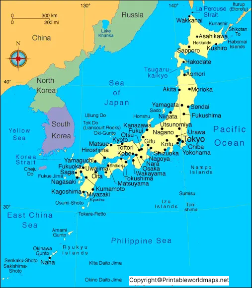
A labeled map of Japan identifies important geographical features and helps readers understand where the country’s main islands and urban areas are located. It is useful for classroom activities, geography revision, travel planning, and general reference.
Japan lies east of the Korean Peninsula, China, and Russia, across surrounding seas and the Pacific Ocean. The Sea of Japan lies to the west of the main Japanese islands, while the Pacific Ocean borders their eastern coastline.
Japan has a total land area of approximately 378,000 square kilometres, according to the Geospatial Information Authority of Japan. The precise figure varies slightly between official measurement dates as geographical data and coastlines are updated.
Labeled Japan Map with States
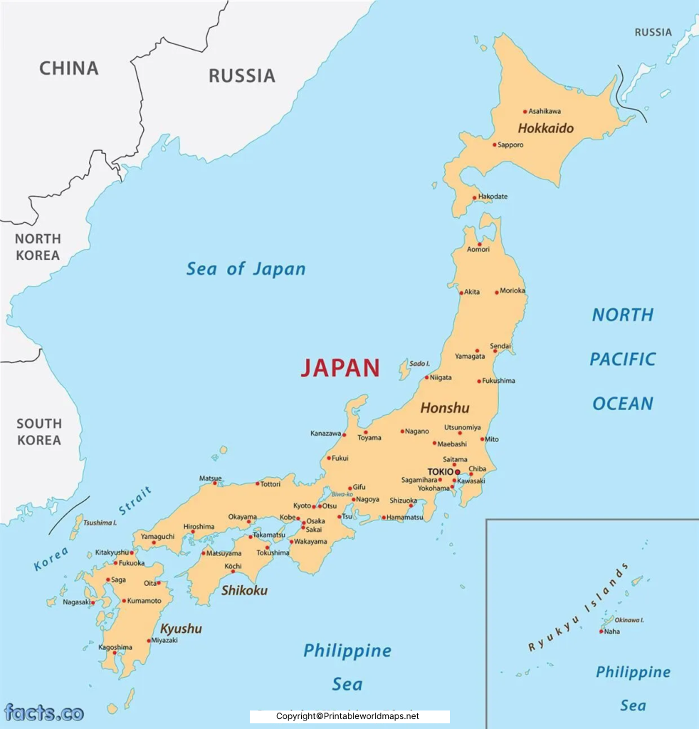
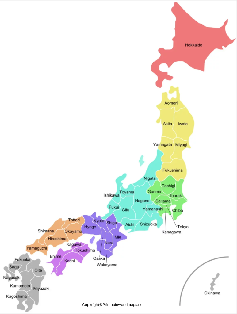
Japan is divided into 47 prefectures, which are the country’s principal prefecture-level administrative divisions. Although they are sometimes described informally as states in English-language map searches, prefectures is the correct administrative term.
The prefectures are commonly grouped into eight geographical regions:
- Hokkaido: The northernmost principal island and its surrounding territory.
- Tohoku: The northeastern part of Honshu.
- Kanto: The region containing Tokyo and nearby prefectures.
- Chubu: Central Honshu, including mountainous areas and the vicinity of Mount Fuji.
- Kansai (Kinki): A region including Osaka, Kyoto, and surrounding prefectures.
- Chugoku: The westernmost region of Honshu.
- Shikoku: The island of Shikoku and its four prefectures.
- Kyushu and Okinawa: Southwestern Japan, including Kyushu and the Ryukyu Islands.
These regional groupings are geographical conventions rather than a separate level of national government. Depending on the map, some regional boundaries or groupings may be presented differently.
A prefecture map is especially helpful for locating administrative boundaries, learning prefecture names, and identifying the areas surrounding major cities.
Labeled Map of Japan with Cities
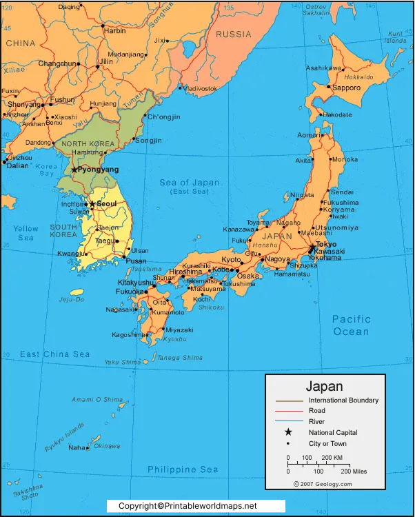
A labeled Japan map with cities helps readers identify important urban centers and understand their locations across the country. Major cities have different roles in Japan’s economy, culture, education, transport, and tourism.
Some important cities and urban centers include:
- Tokyo: Japan’s capital and a major political, commercial, and cultural center.
- Yokohama: A major port city in Kanagawa Prefecture, south of Tokyo.
- Osaka: A large commercial center in the Kansai region.
- Kyoto: Known for its historic temples, shrines, gardens, and traditional architecture.
- Nagoya: A major industrial and transport center in central Japan.
- Sapporo: The largest city in Hokkaido and an important northern urban center.
- Kobe: A port city in Hyogo Prefecture.
- Hiroshima: A major city in western Honshu with important historical sites.
- Sendai: A principal urban center in the Tohoku region.
- Fukuoka: A major city on Kyushu and an important gateway to southwestern Japan.
Other cities, including Nara, Naha, and Nagasaki, are also useful to locate when studying Japanese geography.
Note that Japan has many more cities than those listed here. The cities shown on a map depend on its scale, purpose, and available labeling space.
Labeled Japan with Capital
Tokyo is the capital of Japan. It is located on the eastern side of Honshu, facing Tokyo Bay, within the Kanto region. Tokyo serves as the country’s principal political and administrative center and is home to major business districts, universities, transport networks, and cultural attractions.
Tokyo was historically known as Edo. It became the seat of the imperial government in 1868, when the emperor moved there and the city adopted the name Tokyo.
Important landmarks include the Imperial Palace grounds, Meiji Jingu Shrine, and the Tokyo National Museum. The wider metropolitan area is known for its extensive railway network, modern architecture, shopping districts, traditional neighborhoods, and museums.
When using a Japan capital map, look for Tokyo in the eastern part of Honshu. Its location makes it a useful starting point for understanding the country’s major transport connections and the relationship between the Kanto region and other parts of Japan.
Japan’s Four Principal Islands
Japan’s physical geography is shaped by four principal islands and numerous smaller islands.
Honshu: The largest island, home to Tokyo, Osaka, Kyoto, Nagoya, and many other major cities.
Hokkaido: The northernmost of the four principal islands, known for its extensive natural landscapes, colder winters, and regional cities such as Sapporo.
Kyushu: Located southwest of Honshu, with major cities including Fukuoka and Kumamoto. The island has volcanic landscapes and important transport connections.
Shikoku: The smallest of the four principal islands, located south of western Honshu and known for its coastal scenery and pilgrimage routes.
Okinawa and the Ryukyu Islands extend southwest from Kyushu toward Taiwan. A map that includes these islands provides a more complete picture of Japan’s geographical extent.
Important Geographical Facts About Japan
The following facts provide helpful context when reading a labeled Japan map.
- Location: East Asia, in the northwestern Pacific Ocean.
- Capital: Tokyo.
- Administrative divisions: 47 prefectures.
- Principal islands: Hokkaido, Honshu, Shikoku, and Kyushu.
- Geographical regions: Commonly grouped into eight regions.
- Land area: Approximately 378,000 square kilometres, subject to official measurement updates.
- Landscape: Mountain ranges, volcanic terrain, river valleys, coastal plains, and islands.
- Nearby countries and territories: Japan’s surrounding region includes Russia, the Korean Peninsula, China, and Taiwan across maritime waters.
Japan does not share a land border with another country. References to neighboring countries describe geographical proximity across seas rather than land boundaries.
How to Use and Print a Labeled Map of Japan
A printable map of Japan can support schoolwork, travel planning, presentations, and geography lessons. Choose a map that matches the information you need.
- For learning prefectures: Use the map with prefecture names and boundaries.
- For studying cities: Choose a map that labels major urban centers.
- For locating the capital: Use the capital map to find Tokyo and its position within Honshu.
- For classroom practice: Use a blank outline map to label prefectures, islands, and cities yourself.
- For printing: Open the image or PDF link, download the file, and check the page orientation and print preview before printing.
For a clearer result, choose a high-resolution PDF when available. Make sure small place names remain readable at the selected paper size.
Frequently Asked Questions About the Labeled Map of Japan
1. What is the capital of Japan?
Tokyo is the capital of Japan and its principal political and administrative center.
2. How many prefectures does Japan have?
Japan has 47 prefectures. They are the country’s principal prefecture-level administrative divisions.
3. Does Japan have states?
No. Japan’s administrative divisions are called prefectures, not states. The phrase “Japan map with states” is sometimes used in searches, but “Japan prefectures map” is more accurate.
4. What are the eight regions of Japan?
The commonly used geographical regions are Hokkaido, Tohoku, Kanto, Chubu, Kansai or Kinki, Chugoku, Shikoku, and Kyushu–Okinawa.
5. What are the four main islands of Japan?
The four principal islands are Hokkaido, Honshu, Shikoku, and Kyushu.
6. Which Japanese cities should I look for on a labeled map?
Useful cities to locate include Tokyo, Yokohama, Osaka, Kyoto, Nagoya, Sapporo, Kobe, Hiroshima, Sendai, and Fukuoka.
7. Can I print the labeled map of Japan?
Yes. Open the image or PDF provided in the relevant section and use your browser’s download or print option. Check the file’s resolution and print preview before printing.
8. Where can I find an official map of Japan?
The Geospatial Information Authority of Japan provides official geographical and mapping resources. Its publications are useful when you need authoritative geographical information and administrative area data.
Reference links
https://www.japan.go.jp/japan/index.html
https://www.gsi.go.jp/KOKUJYOHO/MENCHO-title
https://www.stat.go.jp/english/data/handbook/
https://www.japan.travel/en/

1 thought on “Labeled Map of Japan with States, Capital & Cities”