

A labeled map of Algeria helps you identify the country’s capital, major cities, neighboring countries, and administrative divisions. Algeria is located in North Africa and has a Mediterranean coastline in the north. With a total area of approximately 2,381,741 square kilometers, it is the largest country in Africa by land area.
Algeria’s capital is Algiers, an important coastal city and the country’s political and economic center. These printable Algeria maps can help students, teachers, researchers, and travelers understand the country’s geography and locate important places.
Use the labeled maps and downloadable PDF files below for educational purposes, geography projects, and reference.
- World map with continents
- Physical world map
- Political world map
- Labeled map of Asia
- Labeled map of Africa
- Labeled map of Europe
- Labeled map of South America
- World time zone map
- Labeled map of World
- Blank map of world
- Labeled map of North America
- Blank map of Asia
- World map with oceans
- World map poster
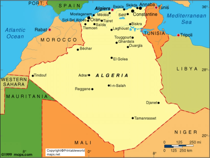
Labeled Map of Algeria
A labeled map of Algeria shows the country’s location, boundaries, coastline, and important geographical features. Algeria shares land borders with Tunisia, Libya, Niger, Mali, Mauritania, Morocco, and the territory of Western Sahara. The Mediterranean Sea lies along its northern coast.
Algeria’s geography includes the Tell Atlas, high plateaus, the Saharan Atlas, and extensive areas of the Sahara Desert. Most of the population lives in the northern part of the country, particularly along the Mediterranean coast.
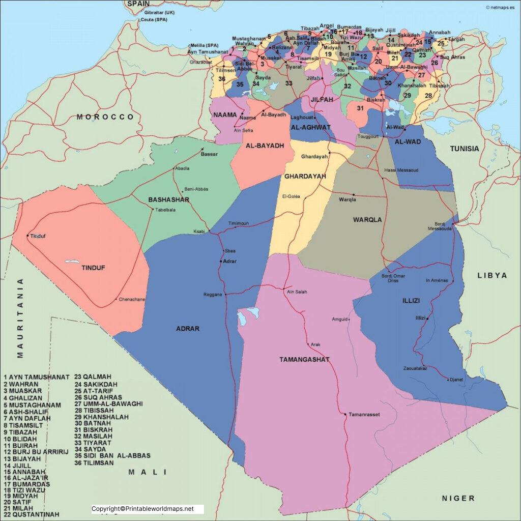
Labeled Map of Algeria with States
A labeled map of Algeria with states helps readers understand the country’s administrative divisions and locate individual regions. Algeria traditionally used 58 wilayas, the administrative units commonly translated as provinces or states.
However, Algeria’s territorial organization changed in 2026. Law No. 26-06, published in the Official Gazette in April 2026, formalized a new division comprising 69 wilayas and 1,541 communes.
This distinction matters when choosing a map. The existing map image below may represent the previous 58-wilaya arrangement. Check its boundaries and labels before using it as a current administrative reference.
For the latest administrative information, consult the Algerian government and the country’s official legal publications.
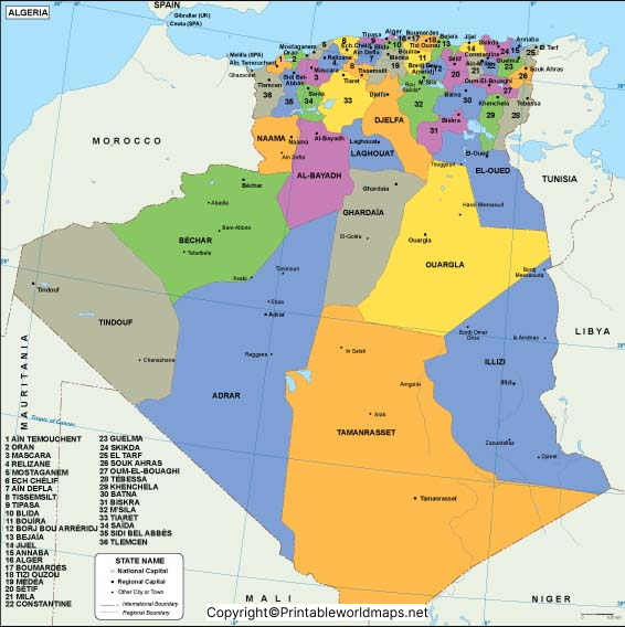
Labeled Map of Algeria with Cities
A labeled map of Algeria with cities helps readers identify major urban centers and understand their positions within the country. Important cities include Algiers, Oran, Constantine, Annaba, Blida, Batna, Sétif, Biskra, Djelfa, and Sidi Bel Abbès.
Algiers is located on the Mediterranean coast. Oran is an important city in northwestern Algeria, while Constantine is known for its dramatic ravines and bridges in the northeast. Annaba is another significant coastal city, close to the Tunisian border.
City maps are useful for geography lessons, school assignments, travel planning, and identifying regional centers. Population rankings can differ depending on whether a source measures the city proper, municipality, or wider metropolitan area.
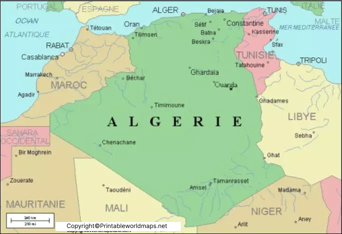
Labeled Algeria with Capital
Algiers is the capital of Algeria and is situated on the country’s Mediterranean coastline. It is the main center of national government and an important hub for commerce, transportation, education, and culture.
The city is known for its historic Casbah, traditional architecture, waterfront setting, and modern urban districts. Its location makes it a useful reference point when studying Algeria’s northern coastal region and the distribution of its major cities.
A labeled Algeria map with the capital marked helps readers distinguish Algiers from other important urban centers, such as Oran and Constantine.
Important Facts About Algeria
Here are some key facts to help readers understand the country’s geography:
- Country: People’s Democratic Republic of Algeria
- Region: North Africa
- Capital: Algiers
- Total area: Approximately 2,381,741 square kilometers
- Population: Approximately 47.4 million in the United Nations’ 2025 data
- Administrative divisions: 69 wilayas under the territorial division formalized in 2026
- Local government units: 1,541 communes
- Northern coastline: Mediterranean Sea
- Major cities: Algiers, Oran, Constantine, Annaba, Blida, and Batna
- Official languages: Arabic and Tamazight
- Currency: Algerian dinar (DZD)
Population figures refer to a specific statistical year and may vary slightly among estimates. Administrative boundaries should be checked against the latest official map.
Geography and Location of Algeria
Algeria occupies a large area of northwestern Africa. Its northern region includes coastal plains, mountain ranges, and populated urban centers. Farther south, the landscape transitions into the Sahara, which covers a substantial part of the country’s territory.
The country’s neighboring land areas include Tunisia and Libya to the east, Niger to the southeast, Mali to the southwest, Mauritania and Western Sahara to the west, and Morocco to the northwest. The Mediterranean Sea forms its northern boundary.
These geographical features make a labeled map particularly useful for understanding Algeria’s location within Africa and its relationship with neighboring countries.
How to Use and Print the Algeria Maps
You can use the maps in this article for school projects, classroom activities, geography assignments, presentations, and personal reference.
- Choose the map that best suits your needs: general geography, administrative divisions, major cities, or the capital.
- Open the PNG image for a quick preview.
- Choose the PDF version when you prefer a document suitable for printing.
- Check the labels and administrative boundaries if you need current official information.
- Print the map at a size that keeps city names and other labels readable.
For an assignment that requires the latest provincial boundaries, use an updated official administrative map rather than assuming an older printable map reflects the 2026 changes.
Frequently Asked Questions
1. Where is Algeria located on the map?
Algeria is located in North Africa. It borders the Mediterranean Sea to the north and several neighboring countries to the east, south, and west.
2. What is the capital of Algeria?
Algiers is the capital of Algeria. It is located on the Mediterranean coast and serves as the country’s main political center.
3. How many wilayas does Algeria have?
Algeria’s territorial division was formalized as 69 wilayas in 2026, alongside 1,541 communes. Older maps may still show the previous 58-wilaya arrangement.
4. Which are the major cities of Algeria?
Major cities include Algiers, Oran, Constantine, Annaba, Blida, Batna, Sétif, Biskra, and Djelfa. Their population rankings depend on the geographical boundaries used for comparison.
5. Can I download a labeled map of Algeria as a PDF?
Yes. This article provides PDF links for the general labeled map, the map with administrative divisions, the cities map, and the capital map.
6. What is the total area of Algeria?
Algeria covers approximately 2,381,741 square kilometers, making it the largest country in Africa by area.
7. Which sea borders Algeria?
The Mediterranean Sea borders Algeria to the north. Its coastline includes several major urban and port areas.
8. Are the Algeria maps on this page up to date?
The images on this page were uploaded in 2023, and the linked PDFs were uploaded in 2025. They should not automatically be treated as reflecting the 2026 administrative changes. Verify the map’s boundaries before using it as an official or current administrative reference.
Reference links
https://data.un.org/en/iso/DZ.html
https://data.worldbank.org/indicator/SP.POP.TOTL?locations=DZ
