

A Map of California is useful for locating the state’s counties, cities, capital, major highways, and geographic regions. This page provides labeled California maps that can be viewed, downloaded, and printed as PDFs for educational, planning, and reference purposes.
You can find a California map with counties, a California map with cities, and additional labeled maps showing the state capital and major highways.
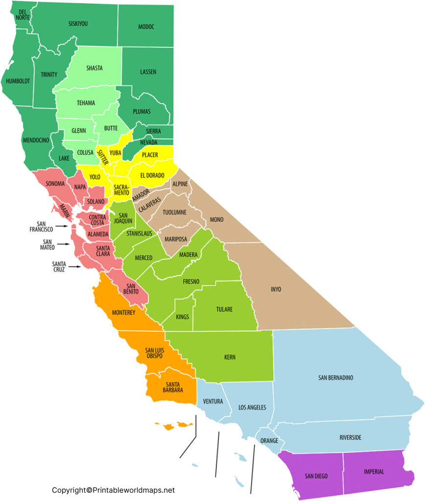
Labeled California Map with Counties
This California map with counties shows the state’s county boundaries and names, making it useful for students, teachers, researchers, travelers, and anyone who needs a simple geographic reference.United States.
California has 58 counties. County boundaries can be useful for understanding local government areas, regional geography, population distribution, and administrative divisions.
Our first map is a CA county map with all the counties of California.
California Geography
California is located on the western coast of the United States. It borders Oregon to the north, Nevada and Arizona to the east, and Mexico to the south.
The Pacific Ocean forms California’s western boundary. The state contains several major geographic regions, including the Coast Ranges, Central Valley, Sierra Nevada, Cascade Range, and Mojave Desert.
California became the 31st state of the United States on September 9, 1850.
The state is commonly known as the Golden State, a nickname associated with the California Gold Rush that began after gold was discovered at Sutter’s Mill in 1848.
Printable Map of California with Cities
A California map with cities makes it easier to locate major urban areas throughout the state.
California’s capital is Sacramento. Other major cities include Los Angeles, San Diego, San Jose, San Francisco, Fresno, Sacramento, Long Beach, Oakland, Bakersfield, and Anaheim.
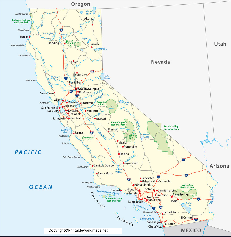
A printable cities map can be useful for:
- Geography assignments
- Classroom activities
- Travel planning
- State geography research
- City-location exercises
- Printable worksheets
- General reference
Labeled California Map with Major Cities
California has a large and diverse network of cities spread across coastal, inland, mountain, and desert regions.
Los Angeles is the state’s largest city by population, while San Diego, San Jose, San Francisco, Fresno, Sacramento, Long Beach, and Oakland are among the other major population centers.

California’s Major Economic Regions
California has a highly diversified economy with important industries including technology, agriculture, entertainment, manufacturing, tourism, trade, and professional services.
The San Francisco Bay Area is strongly associated with technology and innovation, while the Central Valley is an important agricultural region. Southern California has major concentrations of entertainment, international trade, manufacturing, and tourism.
For current economic statistics, refer to official data from the U.S. Bureau of Economic Analysis and California Department of Finance.
Labeled California Map with Highways
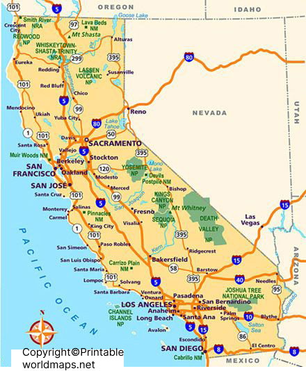
A California highway map can help identify major transportation routes connecting different parts of the state.
Important highways include:
- Interstate 5 (I-5) — A major north-south route through California.
- U.S. Route 101 — Runs through major communities along and near California’s coast.
- Interstate 10 (I-10) — Connects Southern California with other parts of the southwestern United States.
- Interstate 80 (I-80) — Connects the San Francisco Bay Area with Sacramento and continues eastward.
- State Route 99 — A major north-south route through the Central Valley.
California Capital Map
Sacramento is the capital of California.
The city is located in Northern California, where the Sacramento and American Rivers meet. Sacramento is also an important governmental, cultural, and transportation center.
California Map: Counties, Cities and Geography
A Map of California can be used to understand more than city locations. It can also help explain the relationship between counties, metropolitan areas, transportation routes, rivers, mountains, deserts, and coastal regions.
Some important geographic features include:
- Pacific Ocean
- Sierra Nevada
- Central Valley
- Mojave Desert
- Colorado Desert
- Cascade Range
- Coast Ranges
- Sacramento River
- San Joaquin River
- Lake Tahoe
- Death Valley
California’s geography varies considerably from the Pacific coastline to the Sierra Nevada mountains and inland deserts.
Interesting Facts About California
Here are several useful facts to remember when studying a California map:
- California has 58 counties.
- Sacramento is the state capital.
- California became the 31st U.S. state in 1850.
- California is the most populous U.S. state according to recent U.S. Census estimates.
- Mount Whitney is the highest point in the contiguous United States.
- Death Valley contains Badwater Basin, one of the lowest points in North America.
- California includes extensive Pacific coastline.
- The Central Valley is one of the state’s most important agricultural regions.
- California contains both major mountain ranges and extensive desert regions.
- The state has 58 counties and hundreds of incorporated cities and towns.
For population and demographic information, use the U.S. Census Bureau as the primary source rather than relying on older estimates.
How to Use a Printable California Map
A printable California map PDF can be used for several educational and practical purposes.
For Students
Students can use labeled maps to learn:
- County locations
- Major cities
- State capital
- Geographic regions
- Major highways
- Rivers and mountain ranges
For Teachers
Teachers can print the maps for classroom worksheets, geography activities, quizzes, and map-labeling exercises.
For Travel Planning
City and highway maps can provide a simple geographic overview when planning routes between different regions of California.
Frequently Asked Questions
How many counties are in California?
California has 58 counties.
What is the capital of California?
Sacramento is the capital of California.
What is the largest city in California?
Los Angeles is California’s largest city by population.
Can I download a California map as a PDF?
Yes. The maps on this page can be provided as downloadable PDF files for printing and offline reference.
Where is California located?
California is on the western coast of the United States. It borders Oregon, Nevada, Arizona, and Mexico and has the Pacific Ocean along its western side.
What are the major cities in California?
Major California cities include Los Angeles, San Diego, San Jose, San Francisco, Fresno, Sacramento, Long Beach, Oakland, Bakersfield, and Anaheim.
What is California known for?
California is known for its diverse geography, agriculture, technology industry, entertainment industry, major cities, tourism, and Pacific coastline.
What is the Golden State?
The Golden State is California’s official nickname. It is commonly associated with the California Gold Rush and the state’s history.
What is the highest point in California?
Mount Whitney is the highest point in California and the highest point in the contiguous United States.
Reference link
https://www.census.gov/quickfacts/fact/table/CA/PST045225
https://www.usgs.gov/states/california
https://www.nps.gov/state/ca/index.htm
https://www.census.gov/programs-surveys/geography.html
Other Free Printable Maps for You to Download
Please see below a collection of links to other labeled maps and more printable maps in PDF. You will find further free maps via our search feature in the top menu of this page.

1 thought on “Map of California With Counties and Cities [PDF]”