
The Labeled Map of Liechtenstein shows that Liechtenstein is one of the smallest countries in Europe. It is a country located between Switzerland in the west, and Austria in the east. The language spoken here is German. Officially, the country of Liechtenstein is considered a landlocked nation, situated in the Upper Rhine Valley. The country is about twenty-four kilometers or fifteen miles in length from north to south.
- World map with continents
- Physical world map
- Political world map
- Labeled map of Asia
- Labeled map of Africa
- Labeled map of Europe
- Labeled map of South America
- World time zone map
- Labeled map of World
- Blank map of world
- Labeled map of North America
- Blank map of Asia
- World map with oceans
- World map poster
Labeled Map of Liechtenstein
The Labeled Map of Liechtenstein shows the country’s location in Central Europe, its municipalities, capital Vaduz, major populated places, and surrounding borders. Liechtenstein is a small landlocked country situated between Switzerland to the west and Austria to the east in the Upper Rhine Valley.
Liechtenstein covers about 160 square kilometers (62 square miles) and is one of Europe’s smallest countries by area. The country is approximately 24 kilometers (15 miles) from north to south. German is the official language.
The map below is useful for students, teachers, travelers, researchers, and anyone looking for a clear geographic reference to Liechtenstein.
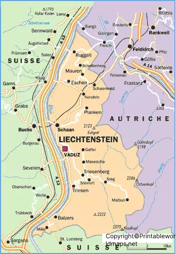
Labeled Map of Liechtenstein with States

Liechtenstein is not divided into states in the same way as countries such as the United States, Germany, or Austria. Instead, the country is divided into 11 municipalities (Gemeinden).
The Labeled Map of Liechtenstein with States is therefore more accurately understood as a map showing Liechtenstein’s municipalities. The 11 municipalities are:
- Balzers
- Vaduz
- Triesen
- Triesenberg
- Schaan
- Planken
- Eschen
- Mauren
- Gamprin
- Ruggell
- Schellenberg
The municipalities are local administrative units and have their own municipal administrations.
Labeled Map of Liechtenstein with Cities
The Labeled Map of Liechtenstein with Cities identifies important populated places throughout the country. Liechtenstein does not have a large urban network because of its small size, but several municipalities are important population and economic centers.
Major municipalities and populated places include:
- Schaan
- Vaduz
- Triesen
- Balzers
- Eschen
- Mauren
- Triesenberg
- Ruggell
- Gamprin
- Schellenberg
- Planken
Schaan is the country’s largest municipality by population, while Vaduz is the national capital.
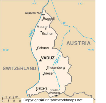
Labeled Liechtenstein Map with Capital
Vaduz is the capital of Liechtenstein and is located in the Rhine Valley near the Swiss border. The Labeled Liechtenstein Map with Capital identifies Vaduz and helps show its position within the country.
Vaduz is the country’s political and administrative center. The Landtag, Liechtenstein’s parliament, is located in Vaduz, along with important government institutions.
One of the city’s best-known landmarks is Vaduz Castle, the traditional residence of the Prince of Liechtenstein. The castle sits on a hillside above Vaduz and is one of the country’s most recognizable landmarks.
Other notable attractions include the Cathedral of St. Florin, the Liechtenstein National Museum, and the Kunst Museum Liechtenstein.
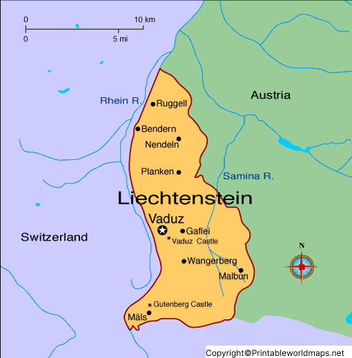
Liechtenstein Geography and Location
Liechtenstein is a landlocked country in Central Europe. It shares:
- Switzerland to the west and south
- Austria to the east and north
The Rhine River forms much of Liechtenstein’s western boundary with Switzerland. The eastern part of the country rises into the Alps, giving Liechtenstein a combination of valley and mountainous landscapes.
The country’s location between Switzerland and Austria makes it geographically distinctive despite its very small size.
Interesting Facts About Liechtenstein
Here are some useful geographic and civic facts that complement the Labeled Map of Liechtenstein:
- Liechtenstein is a landlocked country in Central Europe.
- Its capital is Vaduz.
- The country has 11 municipalities.
- German is the official language.
- The Swiss franc is the country’s currency.
- The Rhine forms much of the western border.
- The country lies between Switzerland and Austria.
- Liechtenstein is a constitutional hereditary monarchy.
- The Alps cover much of the eastern part of the country.
- Vaduz is the country’s political and administrative center.
- Liechtenstein is one of the world’s smallest sovereign states by area.
Liechtenstein Map for Students and Teachers
The Labeled Map of Liechtenstein can be useful for geography lessons, classroom activities, country reports, presentations, and map-reading exercises.
Students can use the map to identify:
- Liechtenstein’s location in Europe
- Neighboring countries
- Vaduz, the capital
- Major municipalities
- The Rhine Valley
- Mountainous areas
- Liechtenstein’s position between Switzerland and Austria
The printable PDF versions can also be useful when a physical map is needed for classroom or educational activities.
Liechtenstein Map PNG and PDF
The maps on this page are provided in image and PDF formats for convenient viewing and printing.
PNG maps are useful for:
- Digital presentations
- Websites
- Online assignments
- Geography projects
PDF maps are useful for:
- Printing
- Classroom worksheets
- Study material
- Offline reference
For the best results, use the PDF version when printing.
FAQs About the Labeled Map of Liechtenstein
What does the Labeled Map of Liechtenstein show?
The map identifies Liechtenstein’s location, municipalities, capital Vaduz, major populated places, and geographic features.
What is the capital of Liechtenstein?
Vaduz is the capital of Liechtenstein.
How many municipalities are there in Liechtenstein?
Liechtenstein has 11 municipalities.
Does Liechtenstein have states?
Liechtenstein does not have states in the conventional sense. It is divided into 11 municipalities (Gemeinden).
Which countries border Liechtenstein?
Liechtenstein borders Switzerland to the west and Austria to the east.
What is the official language of Liechtenstein?
German is the official language of Liechtenstein.
What currency is used in Liechtenstein?
Liechtenstein uses the Swiss franc (CHF) as its currency.
Is Liechtenstein landlocked?
Yes. Liechtenstein is a landlocked country and has no coastline.
What is the largest municipality in Liechtenstein?
Schaan is the country’s largest municipality by population.
Where can I download a printable Liechtenstein map?
Printable PNG and PDF versions of the Labeled Map of Liechtenstein are available in the map sections above.
Reference Links
https://www.statistikportal.li
https://european-union.europa.eu/principles-countries-history/country-profiles/liechtenstein_en









