

A labeled map of Australia with states makes it easier to identify Australia’s six states, two mainland territories, capital cities, major cities, and important geographic features. This page provides printable Australia maps that can be used for geography study, classroom activities, reference, and general learning.
Australia is both a country and the world’s smallest continental landmass. It is the world’s sixth-largest country by area, covering about 7.69 million square kilometres.
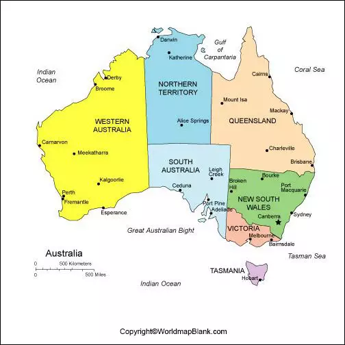
Australia’s national capital is Canberra, located in the Australian Capital Territory (ACT). The country has six states and two mainland territories: New South Wales, Queensland, South Australia, Tasmania, Victoria, Western Australia, the Northern Territory, and the Australian Capital Territory.
The maps below are useful for identifying state boundaries, capital cities, major population centres, and selected geographic features.
Labeled Map of Australia
Our labeled map of Australia provides a geographic overview of the country and can be used to locate major cities, roads, rivers, ports, and selected natural features.
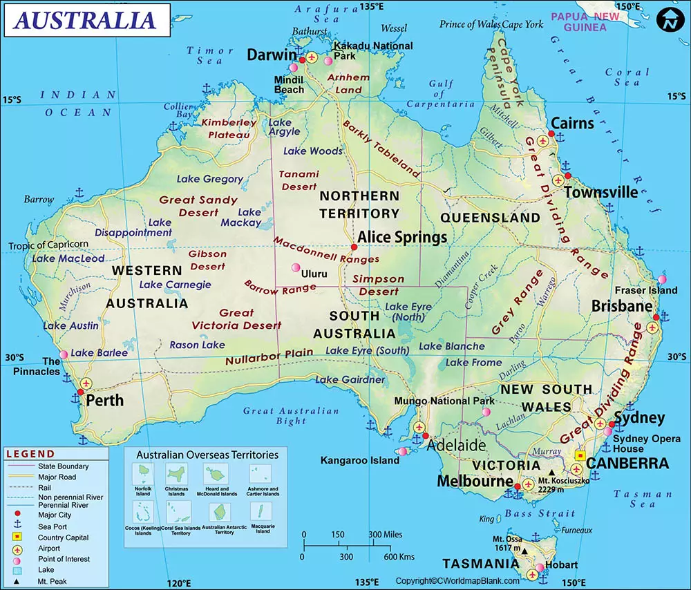
Important geographic features shown or associated with Australia include the Great Barrier Reef, Great Dividing Range, Great Victoria Desert, and Mount Kosciuszko.
Other well-known natural and cultural attractions include Uluru, Kakadu National Park, the Twelve Apostles, and the Snowy Mountains.
Labeled Map of Australia with States and Territories
Australia has six states and two mainland territories. Each has its own capital city. The state and territory boundaries are an important part of understanding Australia’s political and geographic structure.
| State or Territory | Abbreviation | Capital |
|---|---|---|
| New South Wales | NSW | Sydney |
| Queensland | QLD | Brisbane |
| South Australia | SA | Adelaide |
| Tasmania | TAS | Hobart |
| Victoria | VIC | Melbourne |
| Western Australia | WA | Perth |
| Northern Territory | NT | Darwin |
| Australian Capital Territory | ACT | Canberra |
New South Wales
New South Wales (NSW) is Australia’s most populous state. Its capital is Sydney, which is also Australia’s largest capital city by population. The ABS estimated the population of New South Wales at 8.67 million on 31 March 2026.
Queensland
Queensland (QLD) is located in northeastern Australia and has Brisbane as its capital. Its population was approximately 5.74 million on 31 March 2026, according to the ABS.
Victoria
Victoria (VIC) is Australia’s smallest mainland state by area. Its capital is Melbourne. The ABS estimated Victoria’s population at approximately 7.15 million on 31 March 2026.
Tasmania
Tasmania (TAS) is Australia’s island state, located south of the Australian mainland across Bass Strait. Its capital is Hobart. The state had an estimated population of approximately 580,700 on 31 March 2026.
South Australia
South Australia (SA) is located in the central southern part of the country. Its capital is Adelaide. The ABS estimated its population at approximately 1.92 million on 31 March 2026. Australian Bureau of Statistics
Western Australia
Western Australia (WA) occupies the western portion of the country and is Australia’s largest state by area. Its capital is Perth. Western Australia had an estimated population of approximately 3.10 million on 31 March 2026.
Northern Territory
Northern Territory (NT) occupies a large area of northern and central Australia. Its capital is Darwin. The ABS estimated its population at approximately 268,900 on 31 March 2026.
Australian Capital Territory
Australian Capital Territory (ACT) contains Australia’s national capital, Canberra. The ACT had an estimated population of approximately 489,700 on 31 March 2026.
Labeled Map of Australia with Cities
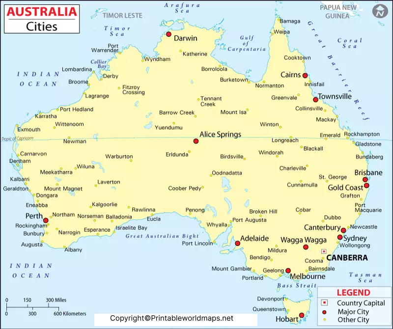
A labeled map of Australia with cities helps students and readers locate the country’s major population centres and capital cities.
The eight state and territory capital cities are:
- Sydney — New South Wales
- Melbourne — Victoria
- Brisbane — Queensland
- Perth — Western Australia
- Adelaide — South Australia
- Hobart — Tasmania
- Darwin — Northern Territory
- Canberra — Australian Capital Territory
The ABS reported the following Greater Capital City Statistical Area (GCCSA) populations at 30 June 2025: Sydney 5,638,830, Melbourne 5,435,590, Brisbane 2,833,524, Perth 2,452,765, Adelaide 1,491,015, Canberra 484,630, Hobart 255,250, and Darwin 159,284. These figures refer to GCCSA statistical areas rather than simply the built-up urban areas.
Sydney
Sydney is the capital of New South Wales and Australia’s largest capital city by population. It is located on Australia’s southeastern coast and is known for landmarks including the Sydney Opera House and Sydney Harbour Bridge.
Melbourne
Melbourne is the capital of Victoria and one of Australia’s largest metropolitan areas. It is located in the southeastern part of the country.
Brisbane
Brisbane is the capital of Queensland and is located in southeastern Queensland. It is one of Australia’s major metropolitan centres.
Perth
Perth is the capital of Western Australia and is located on the country’s western coast.
Adelaide
Adelaide is the capital of South Australia and is located along the southern coast.
Canberra
Canberra is Australia’s national capital and is located within the Australian Capital Territory.
Hobart
Hobart is the capital of Tasmania and is located in the southeastern part of the island state.
Darwin
Darwin is the capital of the Northern Territory and is located on Australia’s northern coast.
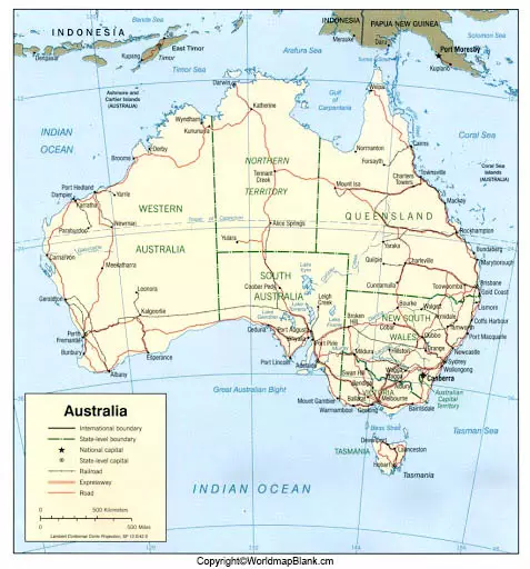
Labeled Australia Map with Capital
A labeled Australia map with capital is particularly useful for identifying Canberra and the capitals of Australia’s six states and two territories.
Canberra is Australia’s national capital. The Canberra–Yass district was selected as the site for the national capital in 1908, and the Australian Capital Territory was established in 1911. Geoscience Australia
Canberra contains major national institutions including Australian Parliament House, the National Gallery of Australia, the National Museum of Australia, and the High Court of Australia. The Parliamentary Education Office identifies Canberra as Australia’s national capital and notes that the federal Parliament is located there.
Australia States and Capitals at a Glance
| State/Territory | Capital City | Location |
|---|---|---|
| New South Wales | Sydney | Southeast |
| Queensland | Brisbane | Northeast |
| South Australia | Adelaide | South |
| Tasmania | Hobart | Southeast island |
| Victoria | Melbourne | Southeast |
| Western Australia | Perth | West |
| Northern Territory | Darwin | North |
| Australian Capital Territory | Canberra | Southeast |
This table provides a quick reference for students, teachers, travellers, and anyone studying Australian geography.
Australia Map Facts
Here are several useful facts to understand when using a labeled Australia map:
- Australia covers approximately 7.69 million km². Geoscience Australia
- Australia is the sixth-largest country in the world by area. Geoscience Australia
- Australia has six states and two mainland territories. Parliamentary Education Office
- Canberra is the national capital. Parliamentary Education Office
- Sydney is the largest capital city by population based on the ABS’s 2025 Greater Capital City estimates. Australian Bureau of Statistics
- Western Australia is the largest state by area. Geoscience Australia
- Tasmania is Australia’s island state.
- Australia’s population was estimated at 27.92 million on 31 March 2026.
Why Use a Labeled Map of Australia?
A labeled map of Australia with states can be useful for:
- Geography lessons and classroom activities
- Identifying Australian states and territories
- Learning state and territory capitals
- Studying major Australian cities
- Understanding Australia’s geographic regions
- Creating school projects and presentations
- Printable geography worksheets
- General reference and map-based learning
The downloadable maps on this page can be used as visual references alongside official Australian geographic and statistical resources.
Frequently Asked Questions
What are the six states of Australia?
The six states are New South Wales, Queensland, South Australia, Tasmania, Victoria, and Western Australia.
What are the two mainland territories of Australia?
The two mainland territories are the Northern Territory (NT) and the Australian Capital Territory (ACT).
What is the capital of Australia?
Canberra is the national capital of Australia and is located in the Australian Capital Territory.
What is the capital of New South Wales?
The capital of New South Wales is Sydney.
What is the capital of Victoria?
The capital of Victoria is Melbourne.
What is the capital of Queensland?
The capital of Queensland is Brisbane.
What is the capital of Western Australia?
The capital of Western Australia is Perth.
What is the capital of South Australia?
The capital of South Australia is Adelaide.
What is the capital of Tasmania?
The capital of Tasmania is Hobart.
What is the capital of the Northern Territory?
The capital of the Northern Territory is Darwin.
How many states and territories does Australia have?
Australia has six states and two mainland territories. Australia also administers other territories, so the broader administrative picture is more extensive than the commonly used six-state/two-territory structure.
What is Australia’s largest state by area?
Western Australia is Australia’s largest state by area, covering approximately 2.53 million km² including its islands.
What is Australia’s smallest mainland state?
Victoria is Australia’s smallest mainland state by area.
Reference Links
https://www.abs.gov.au/statistics/people/population/regional-population/2024-25
https://www.ga.gov.au/data-pubs/maps
More Maps for Free Download and Print
Here is a list of more free printable maps you might be interested in. You can download them all as PDF files and find more via our search bar.
More Australia Maps
Continent Maps
Blank Country Maps
- Blank Map of New Zealand
- United States Blank Map
- Blank Map of France
- Blank Map of Egypt
- Bolivia Blank Map
- Blank Map of Finland
