
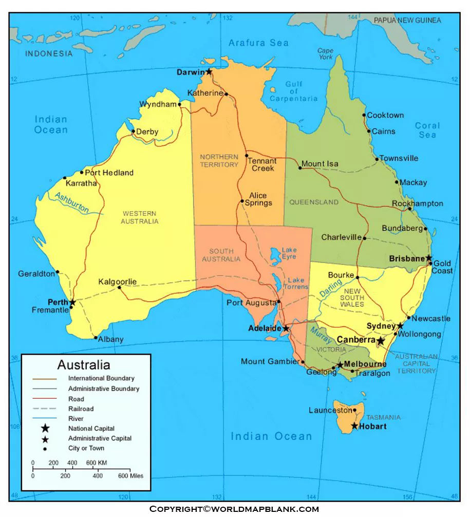

Explore the Australia Rivers Map to discover the major rivers, waterways, and drainage patterns of Australia. This page provides printable river maps, labeled map options, and PDF resources for students, teachers, geography enthusiasts, and anyone learning about Australia’s physical geography.
Use the maps below to identify important rivers, understand their locations, and practice labeling Australian waterways for school assignments, geography lessons, and personal study.
Australia Rivers Map
The Australia Rivers Map helps readers explore the distribution of rivers across the continent. Australia’s river systems vary considerably: some waterways flow regularly, while others have highly variable or intermittent flows depending on rainfall, climate, and local geography.

Australia has several major drainage regions. Some rivers flow toward the sea, while others drain into inland basins where water may collect in lakes, wetlands, or temporary watercourses.
Printable Australia Rivers Map
A printable Australia Rivers Map is useful for learning river locations, studying drainage patterns, and completing geography activities. Students can print the map, identify waterways, and compare the river systems of different Australian states and territories.

For the best results, print the map at a size that keeps river names and labels readable. If you are using it for a classroom activity, consider asking students to mark the river source, direction of flow, major tributaries, and river mouth where these features are shown.
Map of Australia Rivers
The Map of Australia Rivers focuses on the country’s waterways rather than only its political boundaries. It can help readers understand where major rivers are located and how river networks relate to Australia’s landscape.

When studying a river map, remember that a river’s source is the place where it begins, while its mouth is where it ends by flowing into another river, a lake, a wetland, or the sea. A tributary is a smaller river or stream that flows into a larger waterway.
River maps are particularly useful for comparing coastal drainage systems with inland drainage basins. Not every Australian river flows continuously throughout the year, and the flow of many waterways changes with seasonal rainfall.
Map of Australia Rivers Labeled
A labeled Australia Rivers Map makes it easier to identify river names and their approximate locations. It is especially useful for school projects, geography revision, and learning about Australia’s major waterways.

Use the labeled map to locate major waterways and become familiar with their surrounding regions. For additional practice, cover the river names on a printed copy and try to identify them from memory. You can then check your answers against the labeled version.
Major Rivers to Find on an Australia Rivers Map
Several important rivers and river systems help explain Australia’s geography, water resources, and natural environments.
- Murray River: Australia’s longest single river, with an approximate length of 2,508 kilometres according to Geoscience Australia’s published measurements.
- Darling River: A major waterway in eastern Australia that joins the Murray River near Wentworth, New South Wales.
- Murrumbidgee River: An important tributary of the Murray River that flows through New South Wales and the Australian Capital Territory.
- Lachlan River: A significant river in New South Wales that forms part of the wider Murray–Darling river network.
- Flinders River: A major river in Queensland that flows toward the Gulf of Carpentaria.
- Cooper Creek: An inland watercourse that flows through Queensland and South Australia and is associated with the Lake Eyre Basin.
River lengths can differ between sources depending on how channels, tributaries, and connected river systems are measured. For this reason, the Murray River is commonly identified as Australia’s longest single river, while the wider Murray–Darling system is a much longer connected river network.
For verified river measurements and additional geographical details, consult Geoscience Australia.
7 Amazing Facts About Australia’s Rivers
- Australia has diverse drainage regions. Its waterways are grouped into drainage divisions, river regions, and individual river basins.
- The Murray River is Australia’s longest single river. Geoscience Australia reports an approximate length of 2,508 kilometres.
- The Murray–Darling Basin is extensive. It covers more than one million square kilometres across southeastern Australia.
- River flow varies considerably. Rainfall, drought, floods, and climate influence the volume and timing of water flowing through many Australian rivers.
- Some rivers drain inland. Not every waterway reaches the coast; inland rivers may flow toward lakes, wetlands, or terminal basins.
- Rivers support communities and agriculture. Water from major river systems is important for towns, farming, industry, recreation, and ecosystems.
- River maps help explain catchments. A catchment is the area of land from which water drains into a particular river system or outlet.
These facts can be used alongside the printable maps to make geography lessons more engaging and to develop a better understanding of Australia’s physical landscape.
Why Are Australia’s River Systems Important?
Australian rivers contribute to freshwater supplies, agriculture, wetlands, wildlife habitats, and recreational activities. Their importance is particularly clear in the Murray–Darling Basin, which includes connected rivers, floodplains, wetlands, and lakes across several states and territories.
However, Australia’s water resources are unevenly distributed. Rainfall patterns, prolonged dry periods, evaporation, water demand, and environmental conditions all influence river availability. Some waterways experience substantial seasonal changes, while others flow more consistently.
Understanding river locations and drainage patterns helps explain why water management is an important issue in Australia.
How to Use the Printable Australia Rivers Map
You can use the printable maps for several educational purposes:
- School assignments: Identify major rivers and describe their locations.
- Geography practice: Learn the names and positions of Australian waterways.
- Classroom activities: Ask students to label rivers and compare drainage regions.
- Map-reading skills: Study the relationship between rivers, landforms, and coastlines.
- Revision exercises: Use an unlabeled map for practice and the labeled version to check answers.
For a more effective learning activity, choose one major river, trace its course on the map, and research its source, tributaries, destination, and importance to nearby communities.
Frequently Asked Questions About the Australia Rivers Map
1. Where can I download a printable Australia Rivers Map?
You can view the Australia Rivers Map images and access the PDF files linked in this article. Choose the version that best suits your needs and print it for personal study or educational use.
2. What is the longest river in Australia?
The Murray River is commonly identified as Australia’s longest single river, measuring approximately 2,508 kilometres according to Geoscience Australia’s published measurements. The connected Murray–Darling river system is longer when major tributaries are included.
3. Which are the major rivers of Australia?
Major rivers and waterways include the Murray, Darling, Murrumbidgee, Lachlan, Flinders, and Cooper Creek. Their locations and characteristics vary across Australia’s drainage regions.
4. What is the Murray–Darling Basin?
The Murray–Darling Basin is a large river basin system in southeastern Australia. It includes the Murray and Darling rivers, their tributaries, and associated wetlands, floodplains, and lakes across several states and territories.
5. What is a labeled Australia Rivers Map used for?
A labeled map helps readers identify river names and locations. It is useful for school assignments, geography revision, classroom activities, and learning about Australia’s physical geography.
6. Do all Australian rivers flow throughout the year?
No. Many Australian rivers and streams have variable or intermittent flows. Rainfall, drought, climate, and local drainage conditions affect how much water they carry and how long they flow.
7. Why are river maps important for studying Australian geography?
River maps show the distribution of waterways and help readers understand drainage patterns, catchments, inland basins, and connections between rivers and surrounding landscapes.
Conclusion
The Australia Rivers Map is a practical resource for exploring the country’s major waterways and learning about its physical geography. Use the printable, labeled, and PDF versions above for schoolwork, classroom activities, or personal study.
Combining map practice with reliable geographical references can help readers understand Australia’s rivers, drainage systems, and the role waterways play in the country’s environment and communities.
Reference links
https://www.ga.gov.au/scientific-topics/national-location-information/landforms/longest-rivers
https://www.bom.gov.au/water/about/riverBasinAuxNav.shtml
https://www.dcceew.gov.au/water/policy/mdb
https://www.bom.gov.au/water/nwa/2024/mdb/regiondescription/geographicinformation.shtml
https://www.ga.gov.au/scientific-topics/water/national-surface-water-information
