
A Labeled Map of Lithuania helps readers understand the country’s geography, administrative divisions, major cities, neighboring countries, and capital. Officially known as the Republic of Lithuania, Lithuania is located in Northern Europe and is one of the three Baltic States, alongside Latvia and Estonia. The country lies on the southeastern coast of the Baltic Sea and has a rich cultural heritage, beautiful forests, historic cities, and modern infrastructure.
- World map with continents
- Physical world map
- Political world map
- Labeled map of Asia
- Labeled map of Africa
- Labeled map of Europe
- Labeled map of South America
- World time zone map
- Labeled map of World
- Blank map of world
- Labeled map of North America
- Blank map of Asia
- World map with oceans
- World map poster
Labeled Map of Lithuania

Lithuania shares borders with Latvia to the north, Belarus to the east and south, Poland to the southwest, and Kaliningrad Oblast (Russia) to the west. It also has a coastline of approximately 90 km (56 miles) along the Baltic Sea. Its strategic location has made Lithuania an important connection between Central and Northern Europe throughout history.
Covering an area of approximately 65,300 square kilometres (25,212 square miles), Lithuania is the largest of the Baltic countries by land area. According to recent estimates, the country’s population is around 2.9 million people. Nearly one-third of Lithuania is covered by forests, making it one of Europe’s greener nations. The country also contains thousands of lakes, rivers, wetlands, and protected natural parks that contribute to its diverse landscape.
Lithuania is predominantly Roman Catholic, although other religious communities include Orthodox Christians, Lutherans, Old Believers, Muslims, Jews, and Karaites. The official language is Lithuanian, one of the oldest living Indo-European languages.
Labeled Map of Lithuania with Counties
A Labeled Map of Lithuania with Counties illustrates the country’s 10 administrative counties (apskritys), each governed from its own administrative center. These counties are further divided into 60 municipalities, which include city municipalities, district municipalities, and local municipalities.
The ten counties are:
- Alytus County
- Kaunas County
- Klaipėda County
- Marijampolė County
- Panevėžys County
- Šiauliai County
- Tauragė County
- Telšiai County
- Utena County
- Vilnius County
Each county plays an important role in local governance, regional planning, education, healthcare, transportation, and economic development. A labeled county map is particularly useful for students, researchers, travelers, and geography enthusiasts.
Labeled Map of Lithuania with States
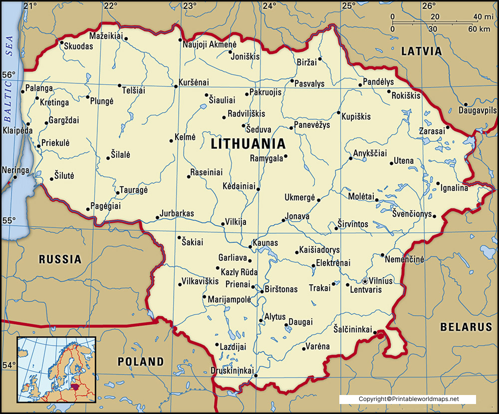
While looking into the labeled map of Lithuania with states, the entire territory of the country is divided into ten counties. They are all named and have their own capitals. Further, these counties are divided into sixty municipalities. Accordingly, they are categorized into nine city municipalities, forty-three district municipalities, and eight municipalities.
Labeled Map of Lithuania with Cities
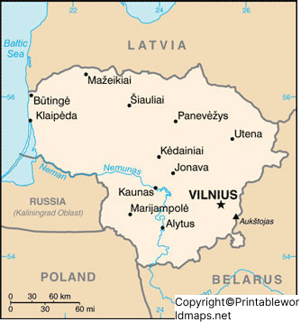
A Labeled Map of Lithuania with Cities identifies the country’s major urban centers and important municipalities. Lithuania has over 100 cities and towns, although only a small number have populations exceeding 20,000 residents.
Some of the most important cities include:
- Vilnius
- Kaunas
- Klaipėda
- Šiauliai
- Panevėžys
- Alytus
- Marijampolė
- Mažeikiai
- Jonava
- Utena
Lithuania is also known for its famous resort towns, including:
- Palanga
- Druskininkai
- Birštonas
- Neringa
- Anykščiai
These destinations attract visitors because of their beaches, spas, forests, lakes, and cultural attractions. The country’s cities are well connected through highways, railways, and public transportation, making travel convenient across the country.
Labeled Lithuania Map with Capital
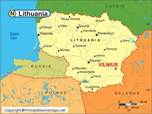
A Labeled Lithuania Map with Capital highlights Vilnius, the political, cultural, educational, and economic center of Lithuania. Located at the meeting point of the Neris and Vilnia rivers, Vilnius is the country’s largest city and one of the oldest capitals in the Baltic region.
Vilnius is internationally recognized for its beautifully preserved Old Town, which is listed as a UNESCO World Heritage Site. The city combines medieval architecture with modern business districts, universities, museums, theatres, and technology companies.
Important landmarks include:
- Vilnius Cathedral
- Gediminas Castle Tower
- Palace of the Grand Dukes
- Gates of Dawn
- Vilnius University
Founded in 1579, Vilnius University is among the oldest universities in Eastern Europe and remains one of Lithuania’s leading educational institutions. Today, Vilnius has become an important center for innovation, finance, tourism, manufacturing, and information technology.
Interesting Facts About Lithuania
- Lithuania regained its independence in 1990.
- The country joined the European Union (EU) and NATO in 2004.
- Lithuania adopted the Euro (€) as its official currency in 2015.
- The highest point in Lithuania is Aukštojas Hill, standing at 294 metres (965 feet).
- The Nemunas River is Lithuania’s longest river.
- The country has more than 6,000 lakes, contributing to its scenic natural beauty.
- Basketball is considered the country’s most popular sport.
- Lithuania is known for its high-speed internet infrastructure and growing technology sector.
What is a labeled map of Lithuania?
A labeled map of Lithuania shows the country’s major geographical features, counties, cities, neighboring countries, rivers, and the capital city, making it useful for education and reference.
Where is Lithuania located on the map?
Lithuania is located in Northern Europe along the southeastern coast of the Baltic Sea. It borders Latvia, Belarus, Poland, and Russia’s Kaliningrad Oblast.
What is the capital of Lithuania?
Vilnius is the capital and largest city of Lithuania. It is the country’s political, cultural, educational, and economic center.
How many counties are there in Lithuania?
Lithuania is divided into 10 counties, which are further subdivided into 60 municipalities.
What are the major cities shown on a labeled map of Lithuania?
Major cities include Vilnius, Kaunas, Klaipėda, Šiauliai, Panevėžys, Alytus, Marijampolė, Utena, Jonava, and Mažeikiai.
Which countries border Lithuania?
Lithuania shares borders with Latvia, Belarus, Poland, and Russia (Kaliningrad Oblast), and has a coastline along the Baltic Sea.
What is the total area of Lithuania?
Lithuania covers approximately 65,300 square kilometres (25,212 square miles).
What is the population of Lithuania?
Lithuania has an estimated population of around 2.9 million people.
What is Lithuania famous for?
Lithuania is known for its medieval history, UNESCO-listed Old Town of Vilnius, beautiful forests, lakes, amber, basketball culture, and rich Baltic heritage.
Why is a labeled map of Lithuania useful?
A labeled map helps students, teachers, travelers, and researchers identify counties, cities, rivers, neighboring countries, and other important geographical features.
What are the neighboring countries of Lithuania?
Lithuania is bordered by Latvia to the north, Belarus to the east and south, Poland to the southwest, and Russia’s Kaliningrad Oblast to the west.
What is the largest city in Lithuania?
Vilnius is both the capital and the largest city in Lithuania.
Which sea borders Lithuania?
Lithuania has a coastline along the Baltic Sea.
What language is spoken in Lithuania?
The official language of Lithuania is Lithuanian, one of the oldest living Indo-European languages.
Is Lithuania part of the European Union?
Yes. Lithuania became a member of the European Union (EU) and NATO in 2004.









