
The Labeled Map of Honduras provides a clear way to explore the country’s departments, cities, capital, borders, and major geographic features. Honduras is a country in Central America, bordered by Guatemala to the west, El Salvador to the southwest, and Nicaragua to the southeast. It has a coastline along the Caribbean Sea and a smaller Pacific coastline along the Gulf of Fonseca.
Honduras is divided into 18 departments, and Tegucigalpa is the national capital. A labeled map is useful for students, teachers, travelers, researchers, and anyone studying the geography of Central America.
- World coronavirus map
- World geographical map
- World Map Wallpaper
- World population map
- Accurate map of World
- Ancient World map
Labeled Map of Honduras
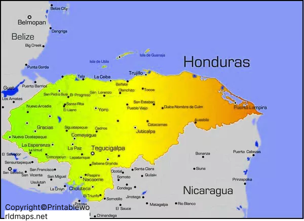
Our Labeled Map of Honduras helps identify important locations and geographic features throughout the country. The map can be used as a visual reference for learning Honduras’s political geography, cities, departments, borders, and physical landscape.
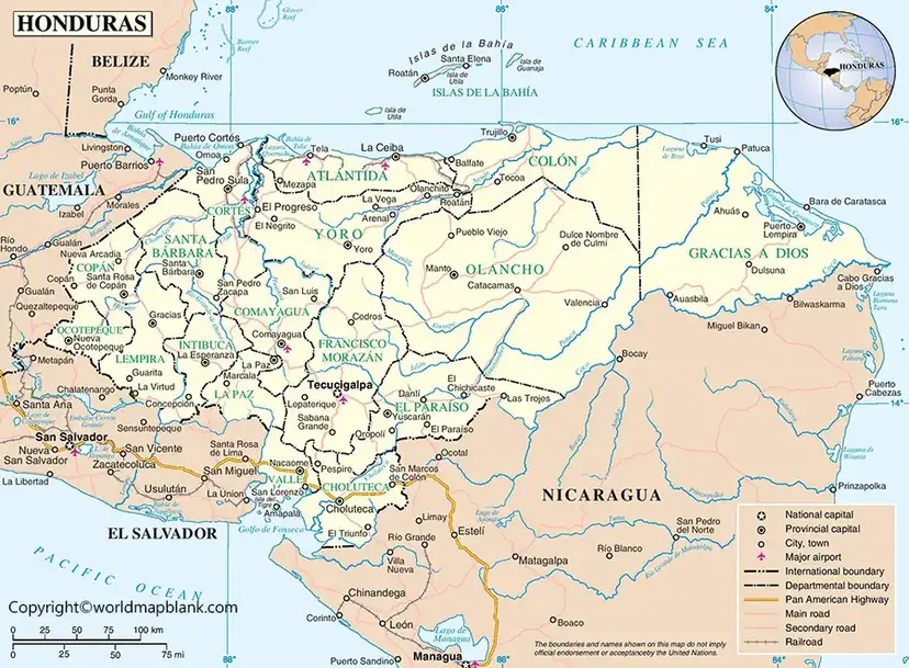
Why Use a Labeled Map of Honduras?
A labeled map makes geographic information easier to understand because locations can be identified visually rather than from a text-only list. It can be particularly useful for:
- Geography lessons and classroom activities
- Learning the 18 departments of Honduras
- Identifying major Honduran cities
- Understanding Honduras’s international borders
- Locating Tegucigalpa, the national capital
- Studying Central American geography
- Printable geography worksheets and reference material
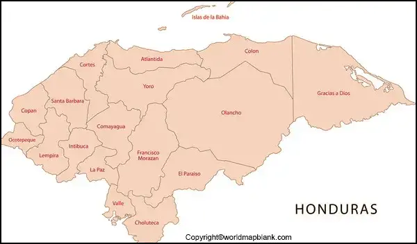
Labeled Map of Honduras with States
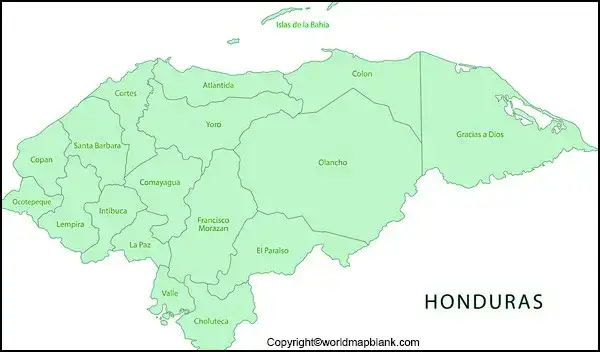
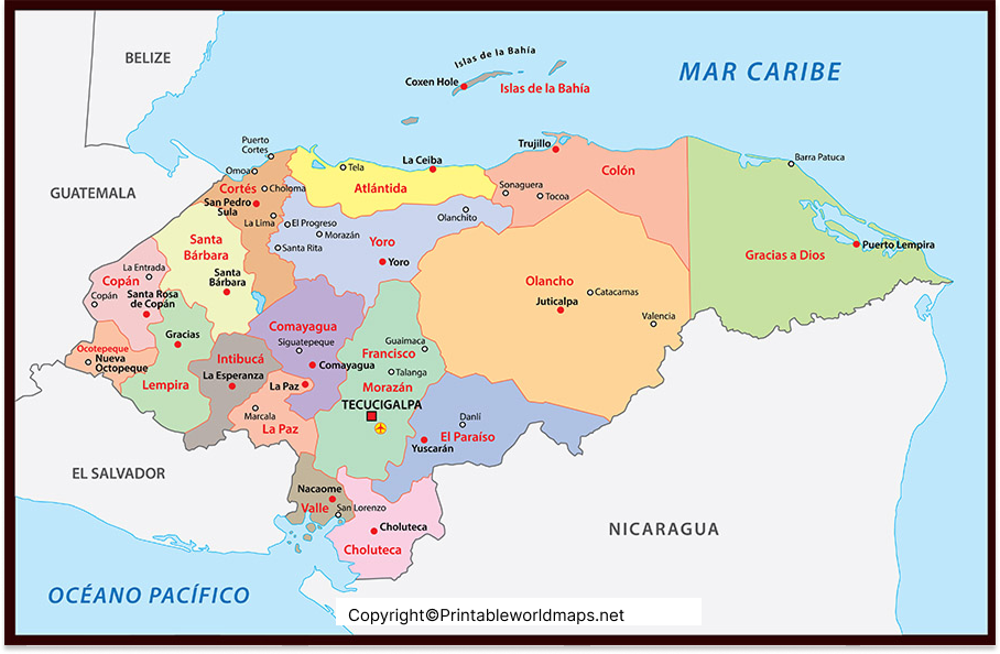
Honduras does not officially use states as its first-level administrative divisions. The country is divided into 18 departments. Therefore, “Labeled Map of Honduras with States” is commonly used as a search phrase, but “Labeled Map of Honduras with Departments” is the more geographically accurate description.
The 18 departments are:
- Atlántida
- Choluteca
- Colón
- Comayagua
- Copán
- Cortés
- El Paraíso
- Francisco Morazán
- Gracias a Dios
- Intibucá
- Islas de la Bahía
- La Paz
- Lempira
- Ocotepeque
- Olancho
- Santa Bárbara
- Valle
- Yoro
A departmental map helps readers understand the administrative organization of Honduras and the relative location of each department.
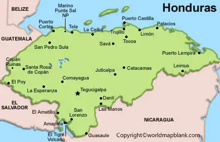
Honduras Map with Cities Labeled
A Honduras map with cities labeled can help identify some of the country’s major urban centers and understand their geographic distribution.
Important cities include:
- Tegucigalpa – national capital and seat of government
- San Pedro Sula – major commercial and industrial center
- La Ceiba – important Caribbean coastal city
- Choloma – major city in Cortés Department
- Comayagua – historic city in central Honduras
- Puerto Cortés – important Caribbean port
- Choluteca – major city in southern Honduras
- Danlí – important city in El Paraíso Department
- Copán Ruinas – gateway to the archaeological site of Copán
A city-labeled map is particularly useful when studying transportation, population centers, tourism destinations, and regional geography.
Labeled Map of Honduras with Capital
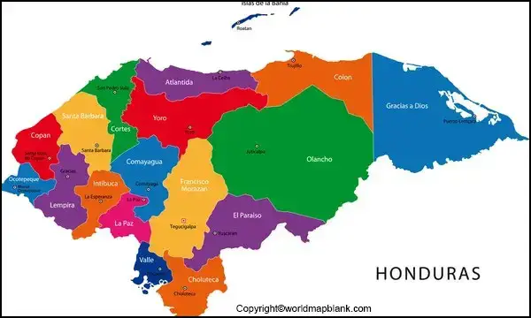
Tegucigalpa is the capital of Honduras. It is located in the department of Francisco Morazán in the country’s central highlands.
Tegucigalpa is commonly discussed together with Comayagüela, forming the Central District. The capital is an important political, administrative, cultural, and economic center of Honduras.
When using a labeled map, look for Tegucigalpa in central Honduras rather than near the Caribbean or Pacific coast.
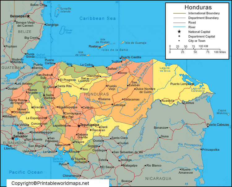
Honduras Geography and Location
Honduras occupies a strategically important position in Central America.
Honduras Borders
Honduras shares land borders with three countries:
- Guatemala – west
- El Salvador – southwest
- Nicaragua – southeast
The country also has maritime coastlines on two bodies of water:
- Caribbean Sea – north
- Gulf of Fonseca – south
This location makes Honduras an important geographic link between northern and southern parts of Central America.
Physical Geography of Honduras
The geography of Honduras includes mountains, valleys, forests, coastal plains, islands, and river systems.
The country’s landscape is predominantly mountainous, particularly through its central and western regions. The Caribbean coast contains extensive lowlands, while the southern region borders the Gulf of Fonseca.
Honduras also includes the Bay Islands, an island group in the Caribbean Sea. Roatán, Utila, and Guanaja are among the best-known islands in the group.
Important Geographic Features to Find on a Honduras Map
A detailed map can help identify several notable geographic features:
- Caribbean Sea
- Gulf of Fonseca
- Bay Islands
- Lake Yojoa
- Sierra del Merendón
- Celaque Mountain
- Patuca River
- Ulúa River
- Caribbean coastal plains
- Southern lowlands
Cerro Las Minas, in western Honduras, is generally recognized as the country’s highest point, reaching approximately 2,849 meters (9,347 feet) above sea level.
Honduras Map: Quick Facts
| Geographic Fact | Information |
|---|---|
| Country | Honduras |
| Official name | Republic of Honduras |
| Region | Central America |
| Capital | Tegucigalpa |
| Administrative divisions | 18 departments |
| Largest city | Tegucigalpa |
| Currency | Honduran lempira |
| Official language | Spanish |
| Northern coastline | Caribbean Sea |
| Southern coastline | Gulf of Fonseca |
| Land borders | Guatemala, El Salvador, Nicaragua |
| Highest point | Cerro Las Minas |
| Time zone | Central Standard Time (UTC−6) |
Honduras in Central America
Honduras is one of the seven countries of Central America. On a regional map, it lies between Guatemala and Nicaragua, with El Salvador located along part of its southwestern border.
Its geographic position provides access to both the Caribbean and Pacific sides of Central America through the country’s northern and southern coastal regions.
Frequently Asked Questions
What is the capital of Honduras?
Tegucigalpa is the capital of Honduras. It is located in the central highlands in Francisco Morazán Department.
How many departments are there in Honduras?
Honduras has 18 departments, which are its primary administrative divisions.
What countries border Honduras?
Honduras shares land borders with Guatemala, El Salvador, and Nicaragua.
Does Honduras have states?
Honduras is divided into 18 departments, not states. “Honduras states” is sometimes used informally in searches, but departments is the correct administrative term.
What is the largest city in Honduras?
Tegucigalpa is the national capital and one of the country’s principal urban centers. San Pedro Sula is another major population and economic center.
What sea borders Honduras?
The Caribbean Sea borders northern Honduras. Honduras also has a southern coastline along the Gulf of Fonseca, which opens into the Pacific Ocean.
What is the highest mountain in Honduras?
Cerro Las Minas, also known as Pico Celaque, is generally recognized as the highest point in Honduras, at approximately 2,849 meters above sea level.
Why is a labeled map of Honduras useful?
A labeled map helps users quickly locate departments, cities, the capital, borders, islands, and physical geographic features. It is useful for education, research, travel planning, and geography reference.
Download Printable Honduras Maps
Readers can use the available printable map resources for classroom activities, geography study, presentations, and personal reference.
Reference Links
https://www.britannica.com/place/Honduras
https://www.cia.gov/the-world-factbook/countries/honduras









