

20 July 2023
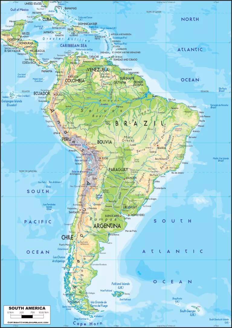
We are here offering the South America Physical Map to all our geographical enthusiasts of the continent. We shall further provide the printable template for the physical map of the South American continent.
Contents [show]
South America Physical Map
South America is the Continent belonging to the Western and Southern hemispheres. It’s the fourth largest continent in the world after Northern America. We also know South America as the southern subcontinent of America due to its close physical presence in North America.
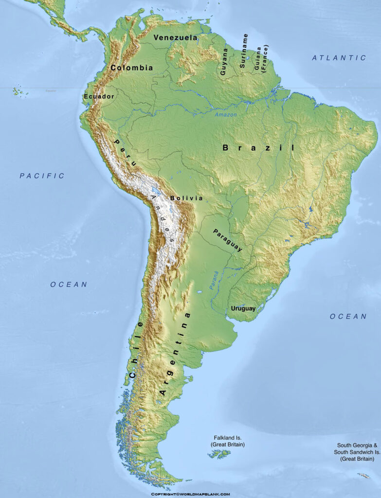
South America with its population of over 423 million people currently stands at the fifth spot in the terms of population. Brazil is the most populous country in South America that contains the majority of the land area of the continent. Argentina, Colombia, Venezuela, Peru, etc are the other major countries of the continent.
Printable South America Physical Map
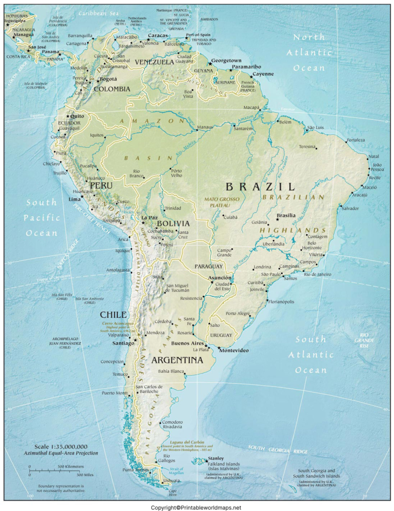
In its physical geography, South America is the continent with record-holding physical characteristics. It contains the world’s longest mountain ranges Andes, the world’s highest waterfalls, the largest river, etc. So, South America is definitely one of the most important continents in its geographical context.
Map of South America Physical
We believe you should start exploring the physical geography of South America with its physical map. The physical map of South America is undoubtedly a very important tool to learn and observe the physical geography of the continent.
It shows up the country-wise physical geography of the continent for the systematic learning of readers. For instance, users can check out the longest Andes mountains of South America that is the part of several countries in the world.
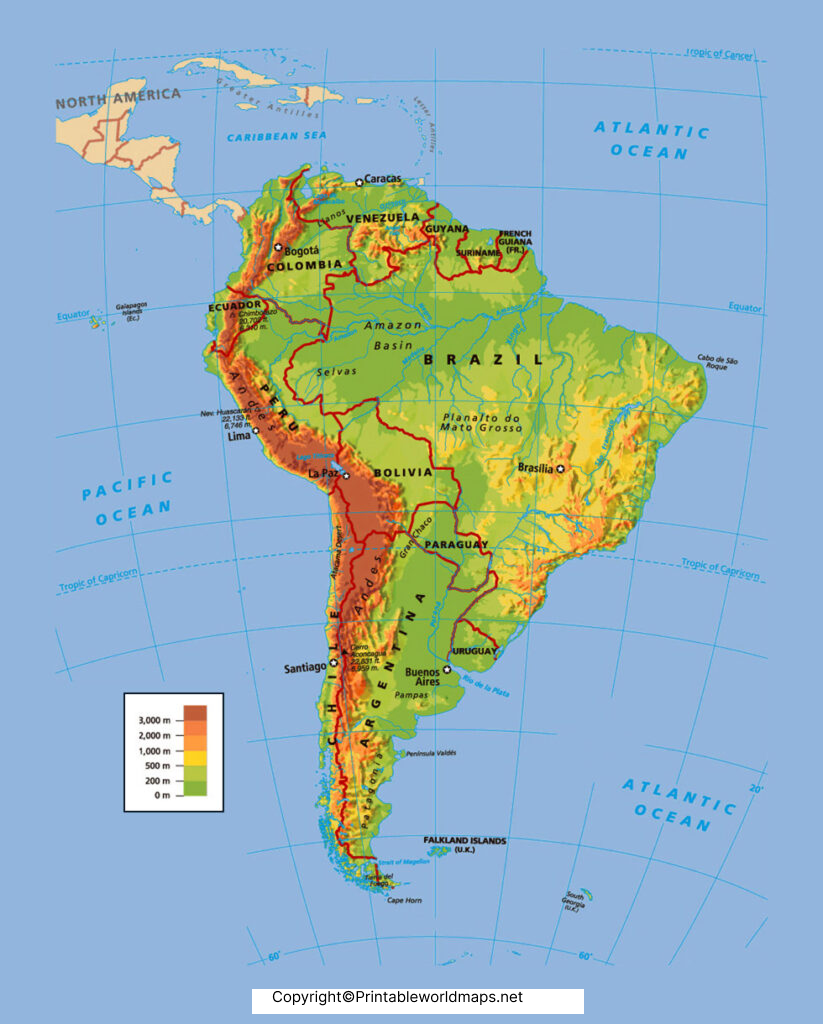
In a similar manner, you can explore other physical objects from the geography of South America. We highly recommend using the physical map of South America to all our users who are interested in South America’s geography.
Physical Map of South America
Check out the printable template of the South America physical map and begin your learning today. The template comes very handily for the users so that they can easily use it for their learning of South America’s physical geography. We have both the printable physical format of the template and also the digital format.
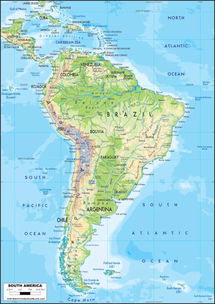
You can use the physical template as the printable physical map of South America. The digital format of the map is very helpful in facilitating the digital learning of the continent’s geography.
So, you can accordingly get the desired format of the South America physical map to suit your learning requirements. Kindly share the template of the South America physical map with other users as well to spread the help around.
South America is the fourth-largest continent by land area. Its landscape ranges from the towering Andes Mountains in the west to the vast Amazon Basin, the Brazilian Highlands, the grasslands of the Pampas, and the dry Atacama Desert. A physical map makes it easier to identify these features and understand how they are distributed across the continent.
You can use the South America physical map provided below for geographical study. Printable PDF versions are also available for convenient offline use.
South America Physical Map
A physical map focuses on the natural landscape rather than political boundaries alone. Depending on its design and legend, it can show mountain ranges, rivers, lakes, highlands, plains, deserts, coastlines, and elevation differences through labels, shading, or colours.
South America is especially interesting because its landforms and climates vary considerably across relatively short distances. The Andes dominate the western side, the Amazon Basin covers a large part of the north-central region, and extensive plains and plateaus occur farther east and south.
Brazil is the continent’s largest country by area. Other countries include Argentina, Peru, Colombia, Chile, Bolivia, Ecuador, Venezuela, Paraguay, Uruguay, Guyana, and Suriname. French Guiana is an overseas department of France on the northeastern coast.
Printable South America Physical Map
A printable South America physical map is helpful when you need a clear reference for homework, classroom activities, quizzes, or geography projects. You can print the map for paper-based study or open the digital version on a computer, tablet, or phone.
For the best results, check the map legend before interpreting colours or symbols. Different maps may use different colour schemes to represent elevation, water bodies, or landforms. If a feature is not labelled, consult a reliable geographical reference rather than assuming its identity from colour alone.
Major Physical Features of South America
The continent has several important natural features worth identifying on a physical map:
- Andes Mountains: A major mountain chain running along the western edge of South America.
- Amazon Basin: A vast drainage basin associated with the Amazon River and its extensive network of tributaries.
- Brazilian Highlands: An extensive region of elevated terrain across much of eastern and central Brazil.
- Guiana Highlands: A highland region north of the Amazon Basin, including parts of Venezuela, Guyana, Suriname, French Guiana, and Brazil.
- Atacama Desert: An exceptionally dry region in northern Chile.
- Pampas: Fertile grasslands mainly associated with Argentina and Uruguay, extending into southern Brazil.
- Patagonia: A large region in southern Argentina and Chile, featuring plateaus, rugged terrain, and glaciers in the Andes.
- Orinoco River Basin: A major drainage region in northern South America, particularly Venezuela and Colombia.
These features help explain the continent’s varied environments, from tropical rainforests to high mountain landscapes and temperate grasslands.
Map of South America Physical
A physical map of South America provides a useful overview of the continent’s terrain and drainage systems. Use it to trace the Andes from the north toward the southern end of the continent, locate the Amazon River system, and compare the mountainous west with the broad lowlands and highlands farther east.
The Andes are the longest continental mountain range on Earth, extending for approximately 8,850 kilometres (5,500 miles), according to National Geographic. Aconcagua, in Argentina near the Chilean border, is the highest mountain in the Andes and the highest peak outside Asia.
The Amazon River system is another major geographical feature. Its vast drainage basin covers parts of several South American countries and supports the Amazon rainforest. Other important drainage systems include the Orinoco and the Paraguay–Paraná river system.
Studying these features together makes it easier to understand how mountains influence river flow, how elevation affects climate, and why different parts of South America support different ecosystems.
Physical Map of South America
This printable physical map of South America can be used for both classroom learning and independent geographical study. Choose the image or PDF format that best suits your needs.
The image format is convenient for quick viewing and digital reference. A PDF is useful when you want to print a map, keep a copy for revision, or use it in a classroom activity. Check the PDF preview and print settings to ensure that labels and geographical details remain readable.
How to Use a South America Physical Map
Follow these simple steps to get more value from the map:
- Locate the Andes Mountains. Find the mountain chain along the western side of the continent.
- Trace the Amazon River system. Observe its general direction of flow toward the Atlantic Ocean and identify tributaries where they are labelled.
- Identify major highlands. Locate the Brazilian Highlands and Guiana Highlands.
- Find the major plains and plateaus. Look for the Pampas and Patagonia, noting their different landscapes.
- Locate the Atacama Desert. Find the arid region along the Pacific side of northern Chile.
- Compare landforms and elevation. Use the map legend to distinguish lowlands from elevated terrain.
- Practise map reading. Cover the labels and try to identify the major features from memory.
Interesting Facts About South America’s Physical Geography
South America has several remarkable geographical features:
- The Andes are the world’s longest continental mountain range.
- Aconcagua reaches approximately 6,962 metres (22,841 feet) above sea level.
- The Amazon River carries more water by volume than any other river on Earth.
- Angel Falls in Venezuela has a total height of approximately 979 metres (3,212 feet).
- The Atacama Desert is among the driest regions on Earth, and some locations have recorded exceptionally long periods without rainfall.
- The Pampas are important grassland areas for agriculture and livestock production.
- South America’s physical environments include tropical rainforests, deserts, grasslands, high plateaus, mountain glaciers, and coastal plains.
These facts show why a physical map is more than a simple geographical reference. It helps learners connect the location of natural features with the continent’s landscapes, climate patterns, river systems, and ecosystems.
Why Is a Physical Map of South America Important?
A physical map is useful because it presents the natural features of a region in a single visual reference. Students can use it to prepare for examinations, complete map-based assignments, and practise identifying mountains, rivers, deserts, plains, and highlands.
Teachers can use printable maps for classroom demonstrations, labelling exercises, and geography quizzes. Researchers and travellers may also find physical maps helpful as a basic reference, although detailed topographic maps are more suitable when precise elevation or route information is required.
For accurate interpretation, use a map with a readable legend and consult authoritative geographical resources when you need detailed information about a specific landform.
Download the version that suits your learning requirements, keep it for future reference, and share the resource with other learners who may find it useful.
Frequently asked questions (FAQs)
1. What is a South America physical map?
A South America physical map shows the continent’s natural features, such as mountains, rivers, lakes, plateaus, plains, deserts, and coastlines. The exact details depend on the map’s labels and legend.
2. Where can I download a printable South America physical map?
You can download a printable map from the PDF links provided in this article. Open a PDF, check the preview, and print it using a suitable paper size and orientation.
3. What are the major physical features of South America?
Major features include the Andes Mountains, Amazon Basin, Brazilian Highlands, Guiana Highlands, Atacama Desert, Pampas grasslands, Patagonia, and the Orinoco and Paraguay–Paraná river systems.
4. What is the highest mountain in South America?
Aconcagua, in Argentina near the Chilean border, is the highest mountain in South America. Its commonly cited elevation is approximately 6,962 metres above sea level.
5. Which river is the most important physical feature of northern South America?
The Amazon River is one of the continent’s most significant geographical features. Its extensive drainage basin supports a vast rainforest and carries enormous volumes of freshwater toward the Atlantic Ocean.
6. What is the difference between a physical map and a political map?
A physical map emphasizes natural features such as mountains, rivers, and elevation. A political map focuses on country boundaries, territories, and administrative divisions, although some maps combine both types of information.
7. How can students use a physical map of South America?
Students can locate major landforms, trace river systems, compare highlands with lowlands, practise map labelling, and prepare for geography examinations.
8. Can I use a South America physical map for school projects?
Yes. A printable map can serve as a geographical reference for school projects, provided you follow the map provider’s usage permissions and credit requirements.
Reference links
https://education.nationalgeographic.org/resource/south-america-physical-geography
https://education.nationalgeographic.org/resource/cerro-aconcagua
https://education.nationalgeographic.org/resource/south-america-resources
https://www.un.org/geospatial/file/2567/download?token=YdpDEbiY
https://education.nationalgeographic.org/resource/south-america-human-geography

1 thought on “South America Physical Map | Map of South America Physical”