
A Labeled Map of Hawaii helps identify the state’s major islands, capital, counties, communities, geographic features, and other important locations. Hawaii is an archipelago in the central Pacific Ocean and became the 50th U.S. state on August 21, 1959. The state is approximately 2,400 miles from the continental United States.
This page provides labeled Hawaii maps for students, teachers, researchers, travelers, and anyone looking for a clear geographic reference. You can also use the printable map and PDF versions below for educational and reference purposes.
Labeled Map of Hawaii
A labeled map of Hawaii can show the state’s major islands, capital, communities, roads, geographic features, and other locations depending on the map version.
Hawaii consists of eight major islands: Hawaiʻi, Maui, Oʻahu, Kauaʻi, Molokaʻi, Lānaʻi, Niʻihau, and Kahoʻolawe. Seven of these major islands are inhabited. The state also includes numerous smaller islands and islets.
The Hawaiian Islands are volcanic in origin. The islands form part of the Hawaiian-Emperor volcanic chain, created as the Pacific Plate moves over a relatively stationary hotspot.
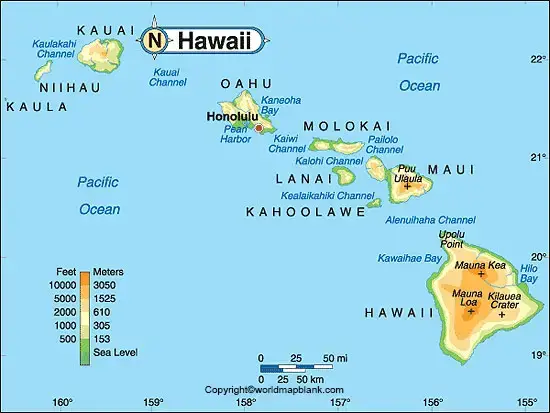
Labeled Hawaii Map Printable
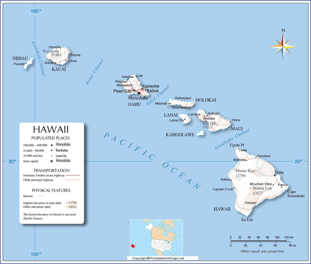
A printable Labeled Hawaii Map is useful for classroom activities, geography assignments, state studies, presentations, and general reference.
The map can help users identify the locations and relative positions of the major Hawaiian islands:
- Hawaiʻi — commonly called the Big Island
- Maui
- Oʻahu
- Kauaʻi
- Molokaʻi
- Lānaʻi
- Niʻihau
- Kahoʻolawe
Hawaiʻi Island is the largest of the major Hawaiian islands, while Kauaʻi is the oldest of the main islands. The islands become progressively younger toward the southeast as part of the volcanic hotspot sequence.
Labeled Map of Hawaii with Cities
A Labeled Map of Hawaii with Cities can help locate major population centers and named communities throughout the state.
However, Hawaii’s geographic terminology is different from that of most U.S. states. Hawaii is the only state for which the U.S. Census Bureau does not recognize incorporated places in the same way it does in other states. Instead, the Census Bureau uses Census Designated Places (CDPs) for many named communities.
Important population centers and communities shown on Hawaii maps may include:
- Honolulu
- Hilo
- Kailua
- Pearl City
- Waipahu
- Kaneohe
- Kahului
- Kihei
- Lihue
- Kailua-Kona
Honolulu is the state capital and is located on Oʻahu. The City and County of Honolulu encompasses Oʻahu and associated Northwestern Hawaiian Islands, excluding Midway Atoll.
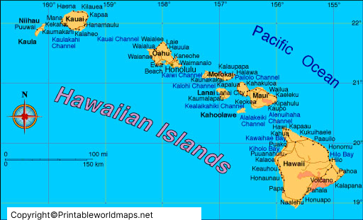
Labeled Hawaii Map with Capital
The capital shown on a Labeled Hawaii Map with Capital is Honolulu.
Honolulu is located on the southeastern coast of Oʻahu and serves as the capital of the State of Hawaiʻi. It is also part of the City and County of Honolulu.
Honolulu is an important center for government, transportation, commerce, tourism, education, and culture in Hawaii.
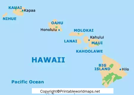
Hawaii Counties on a Labeled Map
Hawaii has five counties or county-level jurisdictions:
- Hawaiʻi County — covers Hawaiʻi Island
- Maui County — includes Maui, Molokaʻi, Lānaʻi, and Kahoʻolawe
- Honolulu County / City and County of Honolulu — primarily Oʻahu and associated Northwestern Hawaiian Islands
- Kauaʻi County — includes Kauaʻi and Niʻihau
- Kalawao County — located on the Kalaupapa area of Molokaʻi
The state government’s descriptions and Hawaii geographic references identify these county-level jurisdictions and their associated islands.
A county map can therefore be useful when studying Hawaii’s political and administrative geography.
Hawaii Map: Area and Population
According to the U.S. Census Bureau, Hawaii has approximately 6,422.48 square miles of land area. The 2020 Census recorded a population of 1,455,271. The Census Bureau’s July 1, 2025 population estimate is 1,432,820.
These figures should be distinguished from older statistics sometimes found on map websites. For example, the original version of this page used 2010 and 2015 population figures. Those historical figures should not be presented as current population data.
Hawaii Population Data
| Year | Population |
|---|---|
| 2010 Census | 1,360,301 |
| 2020 Census | 1,455,271 |
| 2025 Estimate | 1,432,820 |
Source: U.S. Census Bureau.
Major Geographic Features of Hawaii
The Hawaiian Islands are strongly shaped by volcanic activity. The major islands are the exposed portions of a much larger volcanic chain extending across the Pacific Ocean.
Important geographic features include:
- Mauna Kea
- Mauna Loa
- Kīlauea
- Haleakalā
- Diamond Head
- Waimea Canyon
- Hawaiian coastal areas and valleys
The island of Hawaiʻi contains five major volcanoes: Mauna Loa, Kīlauea, Mauna Kea, Hualālai, and Kohala. Mauna Loa and Kīlauea are among the volcanoes historically associated with frequent eruptive activity.
Rivers and Streams in Hawaii
Hawaii does not have the long continental-style river systems found in many mainland states. Its streams are generally associated with steep volcanic terrain and high rainfall.
Examples of named streams and rivers include:
- Wailuku River
- Wailua River
- Hanalei River
- Waimea River
- Kaukonahua Stream
The geography and rainfall patterns of the islands strongly influence the development of streams, valleys, and waterfalls.
Interesting Facts About Hawaii
Here are several useful facts to remember when studying a Labeled Map of Hawaii:
- Hawaii became the 50th U.S. state on August 21, 1959.
- Honolulu is the capital of Hawaii and is located on Oʻahu.
- Hawaii has eight major islands.
- Hawaiʻi Island is the largest of the major islands.
- Hawaii is located approximately 2,400 miles from the U.S. mainland.
- The Hawaiian Islands are volcanic in origin and form part of a large volcanic chain.
- The 2020 Census recorded Hawaii’s population at 1,455,271.
- The 2025 Census Bureau population estimate was 1,432,820.
- Hawaii has five county-level jurisdictions, including Kalawao County.
- Hawaii has no incorporated places recognized by the Census Bureau in the same way as most other states.
Why Use a Labeled Map of Hawaii?
A labeled Hawaii map makes it easier to understand the relationship between the islands, capital, communities, counties, and physical geography.
It can be useful for:
- School geography projects
- Classroom teaching
- State reports
- Printable worksheets
- Travel planning
- Map-reading practice
- Research and presentations
- Learning about U.S. states and territories
For the best educational value, compare a labeled map with an outline or blank Hawaii map. This allows students to practice identifying islands, cities, counties, and geographic features independently.
Frequently Asked Questions About the Labeled Map of Hawaii
What is the capital of Hawaii?
Honolulu is the capital of Hawaii. It is located on the island of Oʻahu.
How many major islands are in Hawaii?
Hawaii has eight major islands: Hawaiʻi, Maui, Oʻahu, Kauaʻi, Molokaʻi, Lānaʻi, Niʻihau, and Kahoʻolawe.
What are the major islands shown on a Hawaii map?
The major islands are Hawaiʻi, Maui, Oʻahu, Kauaʻi, Molokaʻi, Lānaʻi, Niʻihau, and Kahoʻolawe.
How many counties does Hawaii have?
Hawaii has five county-level jurisdictions: Hawaiʻi County, Maui County, Honolulu County, Kauaʻi County, and Kalawao County.
What is the largest island in Hawaii?
Hawaiʻi Island, also known as the Big Island, is the largest of the major Hawaiian islands.
Is Honolulu a city?
Honolulu is part of the City and County of Honolulu. Hawaii’s geographic and statistical system differs from that of most U.S. states, and the Census Bureau does not recognize incorporated places in Hawaii in the usual way.
What is the population of Hawaii?
The 2020 Census recorded 1,455,271 residents. The U.S. Census Bureau estimated Hawaii’s population at 1,432,820 on July 1, 2025.
Can I print a labeled Hawaii map?
Yes. A printable version can be provided as a PDF or high-resolution image for classroom, educational, and reference use.
What volcanoes are shown on maps of Hawaii?
Maps may identify major volcanoes such as Mauna Loa, Kīlauea, Mauna Kea, Hualālai, and Kohala on Hawaiʻi Island, as well as other volcanic features on the neighboring islands.
Reference Links
https://www.census.gov/quickfacts/fact/table/HI/BZA010223
https://data.census.gov/table?g=040XX00US15&q=Hawaii
https://files.hawaii.gov/dbedt/economic/library/facts/Facts_Figures_browsable.pdf
https://www.usgs.gov/publications/geology-hawaiian-islands
https://www.usgs.gov/observatories/hvo/evolution-hawaiian-volcanoes
https://www.usgs.gov/geology-and-ecology-of-national-parks/geology-hawaii-volcanoes-national-park
https://files.hawaii.gov/dbedt/census/geo/hawaii-geo-guide_2020.pdf









