
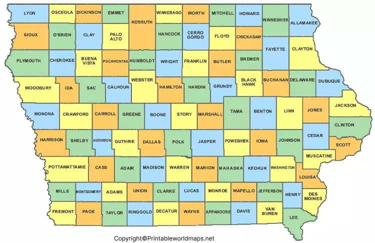
The Labeled Map of Iowa shows the state’s location, capital, major cities, counties, and important geographic features. Iowa is a Midwestern state bordered by Minnesota, Wisconsin, Illinois, Missouri, Nebraska, and South Dakota. The Mississippi River forms much of Iowa’s eastern boundary, while the Missouri River and Big Sioux River are important parts of its western boundary.
This page provides several printable Iowa maps, including labeled maps with cities and a map highlighting the state capital. These maps can be useful for students, teachers, researchers, travelers, homeschool activities, geography projects, and anyone learning about Iowa.
Labeled Map of Iowa
The Labeled Map of Iowa helps identify the state’s position in the central United States and provides a simple geographic reference for Iowa’s major features.
Iowa has a 2025 population estimate of 3,238,387, according to the U.S. Census Bureau. The 2020 Census recorded 3,190,369 residents. Iowa has approximately 55,853.7 square miles of land area and about 419 square miles of water area.
Iowa became the 29th state on December 28, 1846. It has 99 counties, and its state abbreviation is IA.

Iowa Geographic Facts
| Feature | Iowa |
|---|---|
| Capital | Des Moines |
| Statehood | December 28, 1846 |
| Statehood number | 29th state |
| Counties | 99 |
| Abbreviation | IA |
| 2020 Census population | 3,190,369 |
| 2025 population estimate | 3,238,387 |
| Land area | 55,853.7 sq mi |
| Water area | About 419 sq mi |
| Region | Midwestern United States |
| Nickname | Hawkeye State |
The population figures above distinguish the 2020 Census count from the 2025 Census Bureau estimate, which is important when using the map for current educational or research purposes.
Labeled Map of Iowa Printable
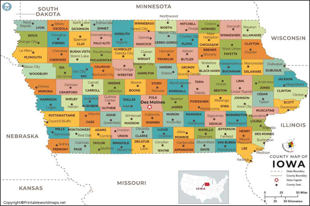
The Labeled Map of Iowa Printable is useful when you need a clean state map for classroom activities, geography worksheets, state studies, or personal reference.
Iowa contains 99 counties, making a labeled county map particularly useful for identifying local government areas and geographic locations. Historical Iowa records show that Des Moines and Dubuque counties were among the earliest counties established in the state.
How to Use a Printable Iowa Map
A printable Iowa map can be used for:
- Geography and state studies
- Classroom and homeschool activities
- Identifying Iowa cities and counties
- Travel and route planning
- Learning Iowa’s neighboring states
- Geography quizzes and worksheets
- Research and presentations
- Printing and marking locations by hand
For school projects, users can print the map and label additional cities, rivers, counties, or neighboring states themselves.
Labeled Map of Iowa with Cities
The Labeled Map of Iowa with Cities identifies important cities and helps users understand their locations across the state.
Major Iowa cities include Des Moines, Cedar Rapids, Davenport, Sioux City, Iowa City, Waterloo, Ames, West Des Moines, Council Bluffs, and Dubuque.
Des Moines is Iowa’s capital and largest incorporated city by population. The U.S. Census Bureau recorded 214,133 residents in Des Moines in the 2020 Census and estimated 213,096 residents in 2024.
Cedar Rapids had 137,710 residents in the 2020 Census and an estimated 137,904 residents in 2024. Davenport had 101,724 residents in the 2020 Census and an estimated 100,358 residents in 2025.
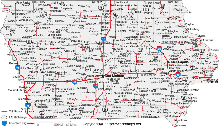
Major Cities Shown on an Iowa City Map
Depending on the map version, users may see locations such as:
- Des Moines
- Cedar Rapids
- Davenport
- Sioux City
- Iowa City
- Waterloo
- Ames
- West Des Moines
- Council Bluffs
- Dubuque
For population research, it is better to use Census Bureau data because city populations change over time and different sources may use different years or geographic definitions. The Census Bureau’s latest completed city-and-town population estimates are the Vintage 2025 estimates.
Labeled Iowa Map with Capital
The Labeled Iowa Map with Capital highlights Des Moines, the capital city of Iowa.
Des Moines became Iowa’s capital in the 19th century after the state government moved from Iowa City. Iowa’s current State Capitol is located in Des Moines. Iowa legislative historical records document the development of the capital and the present Capitol building.
The Iowa State Capitol is a prominent landmark in downtown Des Moines and serves as the seat of Iowa’s state government. The Capitol’s construction began in the 1870s, and the building was dedicated in 1884.
Des Moines, Iowa
Des Moines is located in central Iowa and serves as the state’s political and administrative center. The city is situated near the Des Moines and Raccoon rivers.
The 2020 Census population of Des Moines was 214,133, while the Census Bureau’s 2025 estimate is 212,086. These figures should be identified by year rather than presented as a single permanent population figure.
Important Des Moines landmarks include:
- Iowa State Capitol
- John and Mary Pappajohn Sculpture Park
- Terrace Hill
- Des Moines River
- Raccoon River
Terrace Hill became the official residence of Iowa’s governors in 1976 and is maintained by the State of Iowa.
Iowa Borders and Rivers
Iowa’s geographic position is especially interesting because rivers form significant portions of its eastern and western boundaries.
The state borders:
- Minnesota to the north
- Wisconsin to the northeast
- Illinois to the east
- Missouri to the south
- Nebraska to the west
- South Dakota to the northwest
The Mississippi River forms much of the eastern boundary, while the Missouri River and Big Sioux River form important sections of the western boundary.
Other notable rivers associated with Iowa include the Des Moines River, Iowa River, Cedar River, and Wapsipinicon River.
Iowa Counties and Geography
Iowa has 99 counties. County boundaries are useful for understanding local government, elections, public services, historical research, and regional geography.
The state has a generally rolling landscape, although northeastern Iowa includes areas of more rugged terrain. Iowa’s geography is also closely connected to the Mississippi and Missouri river systems.
A labeled map can therefore be used together with a county map to understand how Iowa’s cities, counties, rivers, and neighboring states relate to one another.
Why Use a Labeled Map of Iowa?
A labeled map provides more information than an outline map because major geographic names are already displayed.
It can help users:
- Quickly locate Iowa’s capital
- Identify major cities
- Understand Iowa’s neighboring states
- Study the state’s geography
- Locate important rivers
- Prepare classroom activities
- Create geography worksheets
- Plan educational projects
- Print and annotate locations
For the best results, use the map together with current Census Bureau data when population or demographic information is required.
Iowa Map Facts at a Glance
Here are several useful facts to remember:
- Iowa is in the Midwestern United States.
- Iowa became the 29th U.S. state on December 28, 1846.
- The state capital is Des Moines.
- Iowa has 99 counties.
- Iowa’s 2020 Census population was 3,190,369.
- The 2025 Census Bureau population estimate is 3,238,387.
- Iowa has about 55,853.7 square miles of land area.
- Iowa borders six states.
- The Mississippi River forms much of the eastern boundary.
- The Missouri River and Big Sioux River are important western boundary rivers.
Frequently Asked Questions
What is the capital of Iowa?
The capital of Iowa is Des Moines. The city serves as the state’s government and administrative center.
How many counties are in Iowa?
Iowa has 99 counties.
What states border Iowa?
Iowa borders Minnesota, Wisconsin, Illinois, Missouri, Nebraska, and South Dakota.
What is the largest city in Iowa?
Des Moines is Iowa’s largest incorporated city by population. The 2020 Census recorded 214,133 residents, and the Census Bureau estimated 212,086 residents in 2025.
What are the major cities in Iowa?
Major Iowa cities include Des Moines, Cedar Rapids, Davenport, Sioux City, Iowa City, Waterloo, Ames, West Des Moines, Council Bluffs, and Dubuque.
When did Iowa become a state?
Iowa became the 29th state of the United States on December 28, 1846.
What river forms Iowa’s eastern boundary?
The Mississippi River forms much of Iowa’s eastern boundary, separating Iowa from Wisconsin and Illinois.
What rivers form part of Iowa’s western boundary?
The Missouri River and Big Sioux River form important portions of Iowa’s western boundary.
Can I print the Iowa maps on this page?
Yes. Printable PDF versions are provided with the map sections above. They can be downloaded and printed for educational, reference, and personal use.
Where can I find current Iowa population data?
The U.S. Census Bureau provides current population estimates and historical Census data for Iowa. The latest completed state population estimate available from the Census Bureau is the 2025 estimae
Reference Link
https://www.census.gov/quickfacts/fact/table/IA/HSG445222
https://data.census.gov/profile/Iowa?g=0400000US19
https://www.census.gov/data/datasets/time-series/demo/popest/2020s-total-cities-and-towns.html
https://www.legis.iowa.gov/resources/tourCapitol/pictorial/capitolPicsPast/capitolConstruction
https://www.legis.iowa.gov/docs/publications/RDBKI/916707.pdf
https://homelandsecurity.iowa.gov/media/213/download
https://www.legis.iowa.gov/docs/publications/REDBK/860898.pdf









