

Antarctica Political Map shows the continent’s major territorial claims, geographic divisions, surrounding waters, and important research locations. This map is useful for students, teachers, researchers, geography enthusiasts, and anyone studying Antarctica’s political geography.
Antarctica is the world’s fifth-largest continent and surrounds the South Pole. It is almost completely covered by ice and is widely recognized as Earth’s coldest continent. NASA identifies Antarctica as the fifth-largest continent, while its ice sheet contains a substantial portion of Earth’s freshwater.
Unlike most continents, Antarctica does not have independent sovereign countries or a conventional system of internationally recognized national borders. Instead, several countries maintain territorial claims, while the Antarctic Treaty System regulates international activity and preserves the positions of states regarding sovereignty claims.
Antarctica Political Map
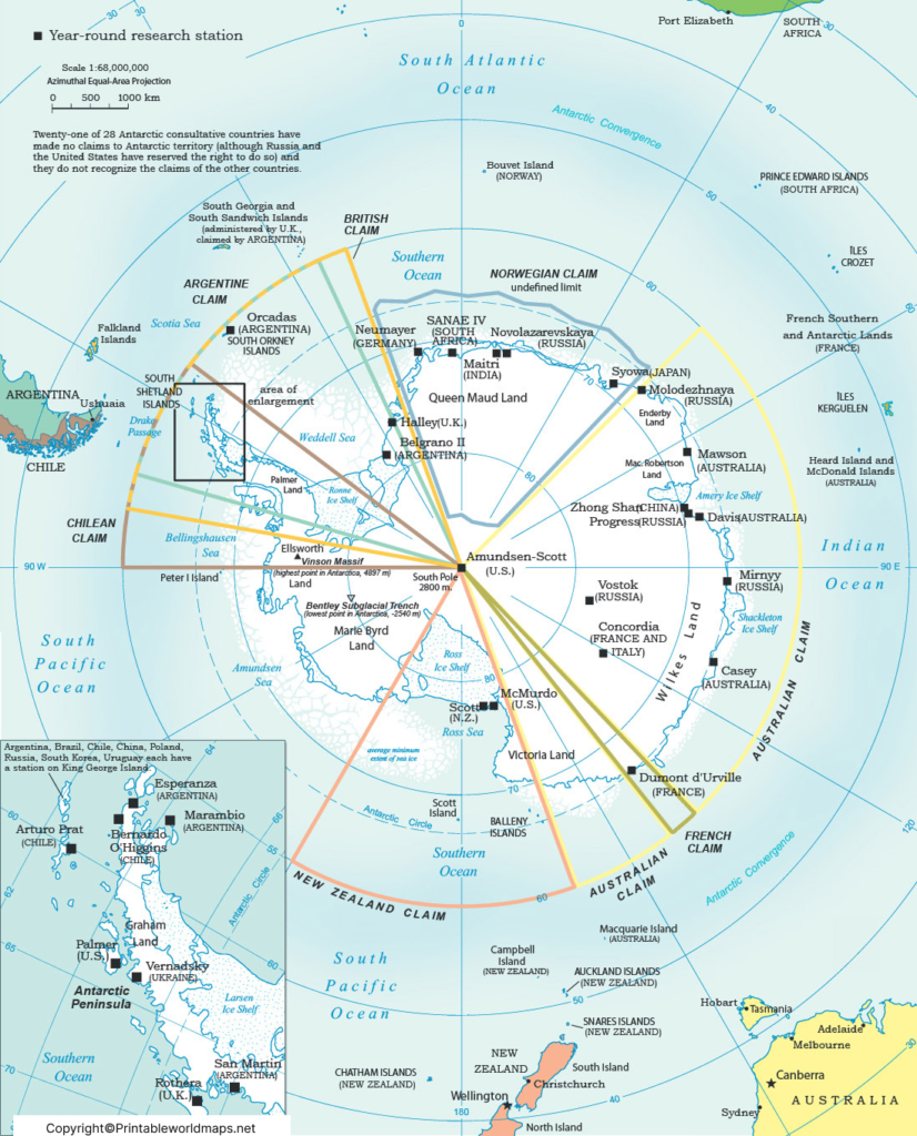
The Antarctica Political Map helps explain the complex territorial geography of the continent. Seven countries have Antarctic territorial claims: Argentina, Australia, Chile, France, New Zealand, Norway, and the United Kingdom. Several of these claims overlap, particularly in the Antarctic Peninsula region.
The political map may therefore show different claim sectors rather than conventional international borders. These sectors are useful for understanding historical claims and the geographic positions maintained by claimant countries.
It is important to distinguish between a territorial claim and internationally recognized sovereignty. The Antarctic Treaty does not settle the sovereignty question. Instead, Article IV protects existing positions and prevents new claims or enlargement of existing claims while the Treaty remains in force.
Countries With Antarctic Territorial Claims
The seven countries that have asserted territorial claims in Antarctica are:
- Argentina
- Australia
- Chile
- France
- New Zealand
- Norway
- United Kingdom
The claims are not all mutually accepted. Argentina, Chile, and the United Kingdom have overlapping claims in parts of the Antarctic Peninsula region.
The United States and Russia do not currently maintain territorial claims comparable to the seven claimant states, but both have historically maintained a basis for a possible claim. The Antarctic Treaty preserves these positions without resolving them.
Map of Antarctica Political
A Map of Antarctica Political is different from a normal country map. Instead of showing recognized national borders, an Antarctic political map commonly illustrates territorial claims, research stations, geographic features, and areas associated with different claimant countries.
The CIA’s Antarctic regional map, for example, identifies the major territorial claims and research stations and notes that many Antarctic Treaty Consultative Parties have made no territorial claims.
This makes the map particularly useful for understanding why Antarctica’s political geography differs from that of populated continents.
Antarctica Political Map Labeled
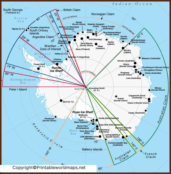
An Antarctica Political Map Labeled can identify territorial claims, research stations, major geographic features, and surrounding seas and oceans.
Depending on the map, labels may include:
- Antarctic Peninsula
- Ross Sea
- Weddell Sea
- Ross Ice Shelf
- South Pole
- Queen Maud Land
- Victoria Land
- Vinson Massif
- McMurdo Station
- Amundsen-Scott South Pole Station
- Major national research stations
A labeled map is especially useful for classroom assignments and geography projects because it combines political information with physical geography.
Territorial Claims in Antarctica
Antarctic territorial claims have a long history and should be interpreted carefully.
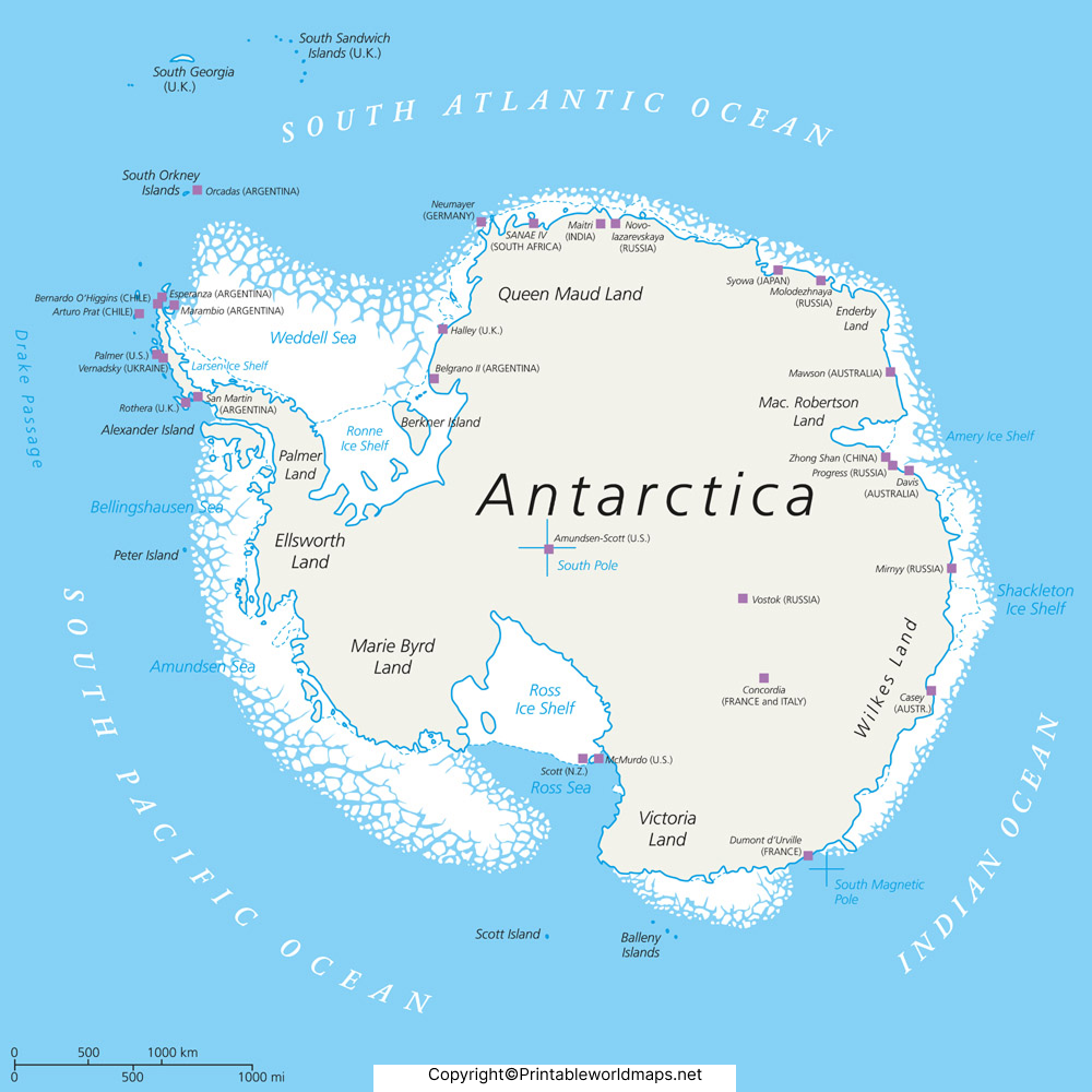
The seven claimant countries have asserted sovereignty over different sectors of Antarctica. Some claims overlap, while some areas have different or undefined claim boundaries. The Antarctic Treaty System does not recognize or reject these claims as a whole; instead, it maintains the existing legal positions of the participating states.
Under Article IV of the Antarctic Treaty, activities carried out while the Treaty remains in force cannot create new rights of sovereignty. The Treaty also states that no new claim, or enlargement of an existing claim, may be asserted while the Treaty is in force.
This is one of the most important facts to understand when reading an Antarctica political map.
Antarctic Treaty and Political Boundaries
The Antarctic Treaty was signed in Washington on December 1, 1959, and entered into force in 1961. It was created following international scientific cooperation during the International Geophysical Year of 1957–58.
The Treaty establishes several important principles, including:
- Antarctica shall be used for peaceful purposes.
- Scientific investigation remains free and encourages international cooperation.
- Scientific observations and results should be exchanged.
- Existing sovereignty positions are preserved rather than settled.
- New territorial claims and enlargement of existing claims are prohibited while the Treaty is in force.
The Antarctic Treaty System is therefore central to understanding why Antarctica does not operate like a conventional continent divided into fully recognized sovereign countries.
Printable Antarctica Political Map
A Printable Antarctica Political Map can be useful for students, teachers, researchers, and geography enthusiasts.
When using a printable map, check whether it identifies:
- Territorial claims
- Claimant countries
- Major research stations
- Antarctic Peninsula
- South Pole
- Major seas and ice shelves
- Important geographic features
- Map projection and scale
For educational use, a high-resolution labeled map is particularly helpful because Antarctica’s large size and complex geography can make small labels difficult to read.
Antarctica Research Stations
Although Antarctica has no permanent native human population, scientists and support personnel from many countries work there.
The British Antarctic Survey reports that up to around 10,000 scientists from 18 countries may be present during the Antarctic summer, while approximately 1,000 scientists remain during winter.
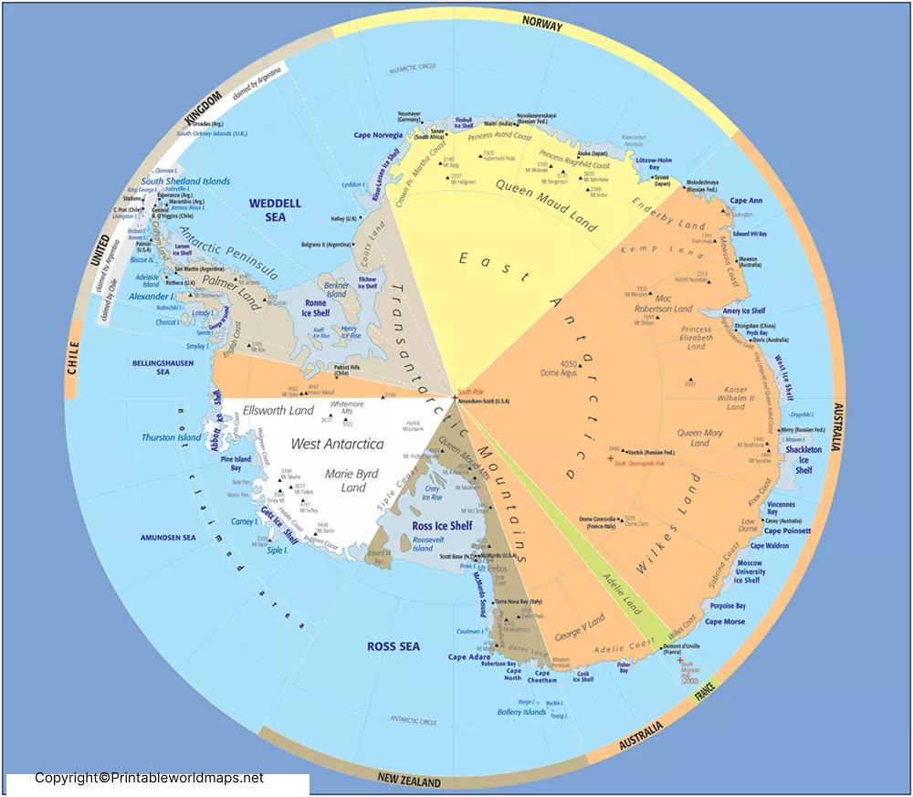
Research stations are therefore an important part of the continent’s human geography. Examples include:
- McMurdo Station — United States
- Amundsen-Scott South Pole Station — United States
- Vostok Station — Russia
- Concordia Station — France and Italy
- Casey Station — Australia
- Davis Station — Australia
- Mawson Station — Australia
- Rothera Research Station — United Kingdom
- Maitri Station — India
A political or regional map of Antarctica may show these stations even though research stations should not be confused with sovereign national territory.
Antarctica Geography Facts
Here are some important facts to understand when studying the Antarctica Political Map:
| Fact | Information |
|---|---|
| Continent | Antarctica |
| Position | Southern Hemisphere |
| South Pole | Located in Antarctica |
| Continental rank by area | 5th largest |
| Permanent native population | None |
| Climate | Extremely cold and dry |
| Territorial claimants | 7 countries |
| Antarctic Treaty signed | 1959 |
| Antarctic Treaty entered into force | 1961 |
| Main purpose of Treaty | Peaceful use and scientific cooperation |
| Highest mountain | Vinson Massif |
| Major human activity | Scientific research |
NASA identifies Antarctica as the fifth-largest continent and notes its extreme cold and extensive ice cover.
Why Antarctica Has No Normal Country Borders
One of the most common misunderstandings about an Antarctica Political Map is assuming that the colored sectors represent ordinary international borders.
They do not.
Antarctica’s political map generally represents territorial claims and legal positions, rather than a collection of universally recognized sovereign states.
The Antarctic Treaty System allows countries to maintain their existing positions while preventing the political situation from being changed through new sovereignty claims. This arrangement has allowed Antarctica to remain focused on peaceful activity and international scientific cooperation.
Antarctica Political Map for Students
The Antarctica Political Map can be used for:
- Geography assignments
- School projects
- World map studies
- Antarctic Treaty studies
- Political geography research
- Printable classroom worksheets
- Research station identification
- Understanding territorial claims
- Learning Antarctic geography
Students should remember that an Antarctic claim shown on a map does not necessarily mean that the international community universally recognizes that territory as sovereign national land.
Interesting Facts About Antarctica
1. Antarctica is the fifth-largest continent.
NASA classifies Antarctica as Earth’s fifth-largest continent.
2. Antarctica is the coldest continent.
NASA reports that the lowest recorded temperature in Antarctica was approximately −89.4°C at Vostok Station.
3. Antarctica has no native human population.
People live and work there primarily for scientific research and associated support activities.
4. Seven countries have territorial claims.
Argentina, Australia, Chile, France, New Zealand, Norway, and the United Kingdom have asserted Antarctic territorial claims.
5. Several claims overlap.
The claims of Argentina, Chile, and the United Kingdom overlap in part of the Antarctic Peninsula region.
6. The Antarctic Treaty was signed in 1959.
It entered into force in 1961.
7. Antarctica is important for climate science.
Its enormous ice sheet stores a major portion of Earth’s freshwater, making the continent critically important to studies of climate and sea-level change.
Frequently Asked Questions
What is an Antarctica Political Map?
An Antarctica Political Map shows territorial claims, geographic sectors, research stations, and other political or administrative information associated with Antarctica.
Which countries claim territory in Antarctica?
Seven countries have territorial claims: Argentina, Australia, Chile, France, New Zealand, Norway, and the United Kingdom.
Is Antarctica divided into countries?
No. Antarctica does not function as a continent divided into universally recognized sovereign countries. Several countries maintain territorial claims, but the Antarctic Treaty preserves the existing positions and prevents new or expanded claims while it remains in force.
Does the Antarctic Treaty cancel territorial claims?
No. Article IV of the Antarctic Treaty preserves the positions of states regarding existing territorial claims while preventing new claims or enlargement of existing claims during the Treaty’s operation.
When was the Antarctic Treaty signed?
The Antarctic Treaty was signed in Washington on December 1, 1959, and entered into force in 1961.
How many people live in Antarctica?
Antarctica has no permanent native human population. The number of scientists and support personnel varies significantly by season; the British Antarctic Survey reports up to about 10,000 scientists during summer and around 1,000 during winter.
What is the highest mountain in Antarctica?
Vinson Massif is the highest mountain in Antarctica, reaching approximately 4,897 meters (16,050 feet) above sea level. The CIA’s Antarctic regional map identifies Vinson Massif as the continent’s highest point.
Can I use a printable Antarctica Political Map for school?
Yes. A printable political map can be useful for geography assignments, classroom activities, and research, provided the map’s source and the status of territorial claims are clearly explained.
Why are territorial claims shown differently on Antarctica maps?
Antarctic maps may use sectors, colors, or labels to illustrate historical or current territorial claims. These should not automatically be interpreted as universally recognized international borders.
Reference Links
- Antarctic Treaty — Official Antarctic Treaty Secretariat
- Antarctic Treaty Article IV — Territorial Claims
- Antarctic Treaty Secretariat — Key Documents
- NASA — Frequently Asked Questions About Antarctica
- NASA — Accurate Map of Antarctica’s Landmass
- British Antarctic Survey — Antarctic Factsheet & Geographical Statistics
- CIA — Antarctic Region Map
