
The Australia Political Map shows the political divisions of Australia, including its six states and two major mainland territories. It is useful for understanding Australia’s states, territories, capital cities, boundaries, and administrative geography.
Australia is both a country and a continent. The country occupies the Australian mainland, the island of Tasmania, and numerous smaller islands. It is the sixth-largest country in the world by total area and the smallest continent by land area.

Australia Political Map

The political map of Australia primarily identifies the country’s six states and two mainland territories:
| State / Territory | Capital |
|---|---|
| New South Wales | Sydney |
| Victoria | Melbourne |
| Queensland | Brisbane |
| Western Australia | Perth |
| South Australia | Adelaide |
| Tasmania | Hobart |
| Northern Territory | Darwin |
| Australian Capital Territory | Canberra |
Australia’s states and territories have different constitutional and administrative arrangements. The six states are New South Wales, Queensland, South Australia, Tasmania, Victoria, and Western Australia. The two major mainland territories are the Northern Territory and Australian Capital Territory (ACT).
Australia also administers several external territories and island territories, including Norfolk Island, Christmas Island, Cocos (Keeling) Islands, Jervis Bay Territory, and the Australian Antarctic Territory, among others.
Map of Australia Political
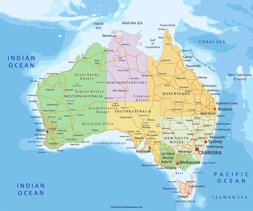
The continent of Australia follows the system of parliamentary constitutional monarchy from the federal government. Queen Elizabeth II is the apex monarch of the Australian realms. We further urge our readers to follow the political map of Australia so as to get a better idea of its political boundaries. They can check out the printable Australian political map in the article ahead.
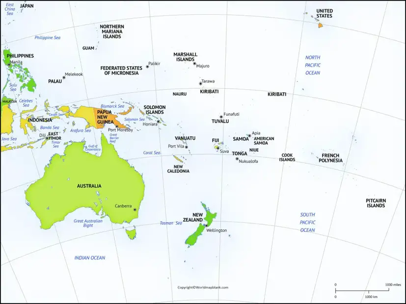
Printable Australia Political Map
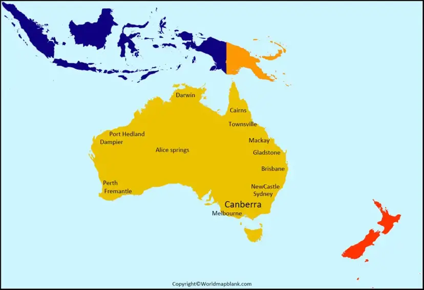
A Map of Australia Political is useful for identifying the boundaries between Australia’s states and territories and locating their respective capital cities.
Australia is a federal parliamentary constitutional monarchy. The Commonwealth of Australia was established as a federation on 1 January 1901, when the six colonies united to form the Commonwealth.
The national capital is Canberra, located within the Australian Capital Territory between Sydney and Melbourne.
Unlike the outdated description in the original article, Papua New Guinea and Indonesia are separate countries and are not political subdivisions of Australia.
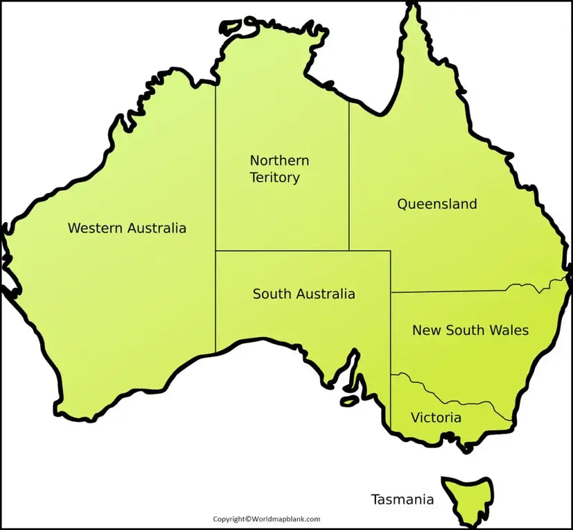
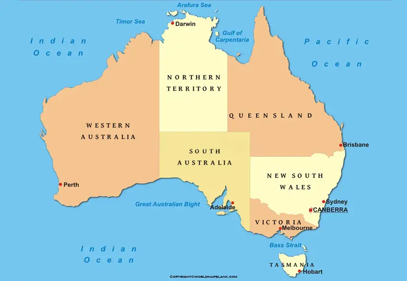
States and Territories of Australia
Australia’s political geography is divided between states and territories. States have constitutional powers that differ from those of territories, although both play major roles in Australia’s system of government.
New South Wales
Capital: Sydney
New South Wales is located on Australia’s southeastern coast. Sydney is the state capital and Australia’s largest city by population.
Victoria
Capital: Melbourne
Victoria is Australia’s southeastern mainland state. Melbourne is its capital and a major cultural, economic, and educational center.
Queensland
Capital: Brisbane
Queensland occupies much of northeastern Australia. Brisbane is the state capital, while the state is also known for the Great Barrier Reef and tropical northern coastline.
Western Australia
Capital: Perth
Western Australia occupies the western portion of the Australian continent. Perth is the capital and largest city of the state.
South Australia
Capital: Adelaide
South Australia is located in the southern part of the country. Adelaide is its capital and largest metropolitan center.
Tasmania
Capital: Hobart
Tasmania is an island state separated from mainland Australia by Bass Strait. Hobart is the state’s capital.
Northern Territory
Capital: Darwin
The Northern Territory occupies a large area of northern and central Australia. Darwin is its capital and northernmost major city.
Australian Capital Territory
Capital: Canberra
The Australian Capital Territory contains Canberra, Australia’s national capital. The territory is surrounded by New South Wales.
Australia Political Map Labeled
An Australia Political Map Labeled with state and territory names makes it easier to study Australia’s administrative geography.
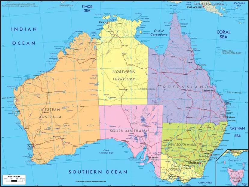
A labeled map can show:
- State and territory boundaries
- State and territory names
- Capital cities
- Major cities
- Coastal boundaries
- Surrounding oceans and seas
- Neighboring countries and regions
- Australia’s external territories, where applicable
For students, teachers, researchers, travelers, and geography enthusiasts, a labeled political map provides a convenient visual reference for learning Australia’s administrative divisions.
Printable Australia Political Map
A Printable Australia Political Map can be useful for classrooms, geography assignments, presentations, study materials, and general reference.
When printing a political map, a high-resolution version is preferable because small labels such as territory names and capital cities can become difficult to read at lower resolutions.
For educational use, a map with clear state boundaries and capital-city labels can help students identify Australia’s administrative divisions without relying solely on text.
Australia Political Map with Capitals
The political geography of Australia is particularly easy to study by connecting each state or territory with its capital.
The eight state and territory capitals are:
Sydney, Melbourne, Brisbane, Perth, Adelaide, Hobart, Darwin, and Canberra.
Canberra is Australia’s national capital, while the other seven cities serve as state or territory capitals.
One useful distinction when studying an Australia political map is that Canberra is not part of New South Wales. It is located within the separately administered Australian Capital Territory.
Australia and Its Neighboring Countries
Australia is geographically isolated from most other countries. Its maritime neighbors include countries such as Indonesia, Papua New Guinea, Timor-Leste, and New Zealand, although the exact relationship depends on whether geographical proximity or maritime boundaries are being considered.
Australia’s northern coastline faces the Timor Sea, Arafura Sea, and Torres Strait, while the country’s western, southern, and eastern shores meet the Indian and Pacific Ocean regions.
Australia Political Map Facts
Here are some useful facts for understanding Australia’s political geography:
- Official name: Commonwealth of Australia
- Capital: Canberra
- Largest city: Sydney
- States: 6
- Mainland territories: 2
- Federation: 1 January 1901
- Government: Federal parliamentary constitutional monarchy
- Currency: Australian dollar (AUD)
- Official language: Australia does not have a legally designated official language at the federal level; English is the predominant language.
- Continent: Australia
- Country area: Approximately 7.69 million km²
- Neighboring region: Indonesia and Papua New Guinea are among Australia’s northern neighbors.
Australia Political Map for Students
The political map is particularly useful for geography students because it combines physical location with administrative boundaries.
Students can use the map to learn:
- Australia’s six states.
- Australia’s two major mainland territories.
- The capital of each state and territory.
- The location of Canberra.
- The position of Tasmania relative to mainland Australia.
- The geographic location of Australia’s neighboring countries.
- Australia’s major political and administrative boundaries.
A labeled map can also be used as a study aid before geography examinations or as a reference when completing map-labeling exercises.
Australia Political Map vs. Physical Map
A political map and a physical map show different types of geographic information.
| Political Map | Physical Map |
|---|---|
| Shows state and territory boundaries | Shows natural landforms |
| Identifies capitals and major cities | Shows mountains, rivers and deserts |
| Shows administrative divisions | Shows elevation and terrain |
| Focuses on human geography | Focuses on physical geography |
For a complete understanding of Australia’s geography, it can be useful to study both map types together.
Important Geographic Correction
Some older descriptions of Australia’s political geography incorrectly describe Australia as consisting of several countries or include Papua New Guinea and Indonesia as part of the Australian political map.
This is incorrect.
Australia is a sovereign country. Its principal internal political divisions are six states and two mainland territories. Papua New Guinea and Indonesia are independent neighboring countries, not Australian states or territories.
This distinction is important when using an Australia political map for educational or research purposes.
How to Use an Australia Political Map
An Australia political map can be used for:
- Geography education
- School assignments
- Classroom teaching
- State and territory identification
- Capital-city learning
- Travel planning
- Research and presentations
- Map-labeling exercises
- General geographic reference
For the most accurate interpretation, users should check the map’s publication or update date, especially when studying administrative boundaries, territories, or government-related information.
Frequently Asked Questions
How many states are there in Australia?
Australia has six states: New South Wales, Victoria, Queensland, Western Australia, South Australia, and Tasmania.
How many territories does Australia have?
Australia has two major mainland territories: the Northern Territory and the Australian Capital Territory. Australia also administers several external territories.
What is the capital of Australia?
Canberra is the national capital of Australia. It is located in the Australian Capital Territory.
What is the largest state in Australia?
Western Australia is Australia’s largest state by area.
Is Sydney the capital of Australia?
No. Sydney is the capital of New South Wales. Australia’s national capital is Canberra.
Is Tasmania part of Australia?
Yes. Tasmania is an Australian state located on an island south of mainland Australia.
Are Papua New Guinea and Indonesia part of Australia?
No. Papua New Guinea and Indonesia are separate sovereign countries. They are geographically close to Australia, particularly in the country’s northern region.
What does an Australia political map show?
An Australia political map generally shows states, territories, administrative boundaries, capital cities, major cities, and other political or administrative features.
When did Australia become a federation?
The Commonwealth of Australia was established on 1 January 1901, when the six Australian colonies federated.
What is the difference between an Australian state and territory?
States and territories both have elected governments and administrative responsibilities, but their constitutional arrangements and powers are different. The Australian Constitution provides states with powers that are not structured in exactly the same way as those of territories.
Australia Political Map: Key Takeaway
The Australia Political Map provides a clear way to understand the country’s administrative geography. Australia consists principally of six states and two mainland territories, with Canberra serving as the national capital.
For accurate geographic study, it is important to distinguish Australia’s internal political divisions from nearby independent countries such as Indonesia and Papua New Guinea. A labeled and updated political map makes these distinctions much easier to understand.
References
- https://www.australia.gov.au/
- https://www.ga.gov.au/
- https://www.abs.gov.au/
- https://www.aph.gov.au/
- https://www.dfat.gov.au/
- https://www.un.org/geospatial/
- https://www.australia.com/en/facts-and-planning/about-australia/states-and-territories.html
- https://www.infrastructure.gov.au/territories-regions-cities/territories/australian-capital-territory
- https://www.niaa.gov.au/
- https://www.antarctica.gov.au/about-antarctica/australia-in-antarctica/









