
A Labeled Map of Bangladesh helps identify the country’s administrative divisions, capital, major cities, rivers, transportation routes, and other important geographic features. Bangladesh is located in South Asia and borders India, Myanmar, and the Bay of Bengal.
The country is largely a low-lying delta formed by major river systems, including the Ganges (Padma), Brahmaputra (Jamuna), and Meghna. This geography has played an important role in Bangladesh’s agriculture, settlements, transportation, and economy.
Our labeled Bangladesh maps are useful for students, teachers, researchers, travelers, geography projects, and anyone looking for a printable reference map.
Labeled Map of Bangladesh
The Labeled Map of Bangladesh identifies important geographic locations and provides a visual overview of the country. Dhaka is the national capital and one of the country’s principal urban and economic centers.

The map can be used as a quick geographic reference for locating the capital, major cities, administrative areas, roads, railways, and airports shown on the map.
Labeled Map of Bangladesh with States
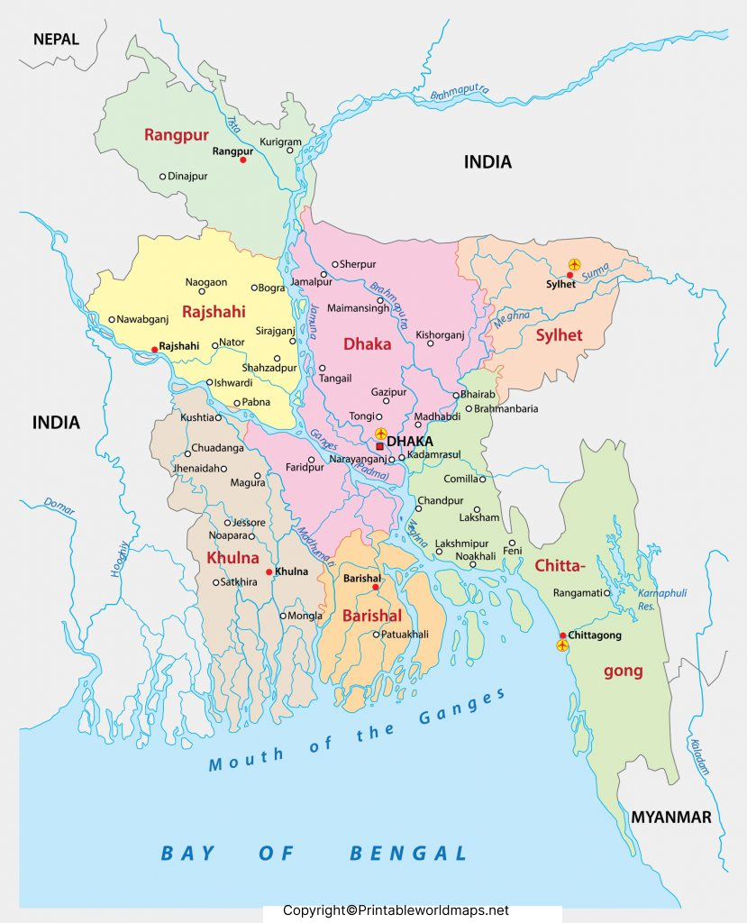
Bangladesh does not officially use states as its primary first-level administrative divisions. Instead, the country is divided into 8 administrative divisions, which are further divided into districts.
The eight divisions are:
- Barishal Division
- Chattogram Division
- Dhaka Division
- Khulna Division
- Mymensingh Division
- Rajshahi Division
- Rangpur Division
- Sylhet Division
Labeled Map of Bangladesh with Cities
A Labeled Map of Bangladesh with Cities makes it easier to locate important urban centers throughout the country. Major cities include Dhaka, Chattogram, Khulna, Rajshahi, Sylhet, Rangpur, Mymensingh, Barishal, Gazipur, and Narayanganj.
Dhaka is the national capital and the country’s largest metropolitan center. Chattogram is an important port city and a major commercial center.
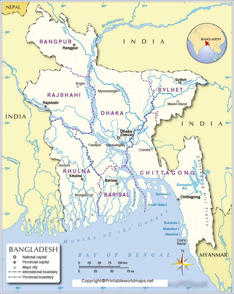
Labeled Bangladesh Map with Capital
The Labeled Bangladesh Map with Capital identifies Dhaka, the capital city of Bangladesh. Dhaka is located in the central part of the country, near the Buriganga River.
Dhaka is an important center for government, business, education, finance, manufacturing, and transportation. The wider Dhaka metropolitan area is one of the country’s most densely populated urban regions.
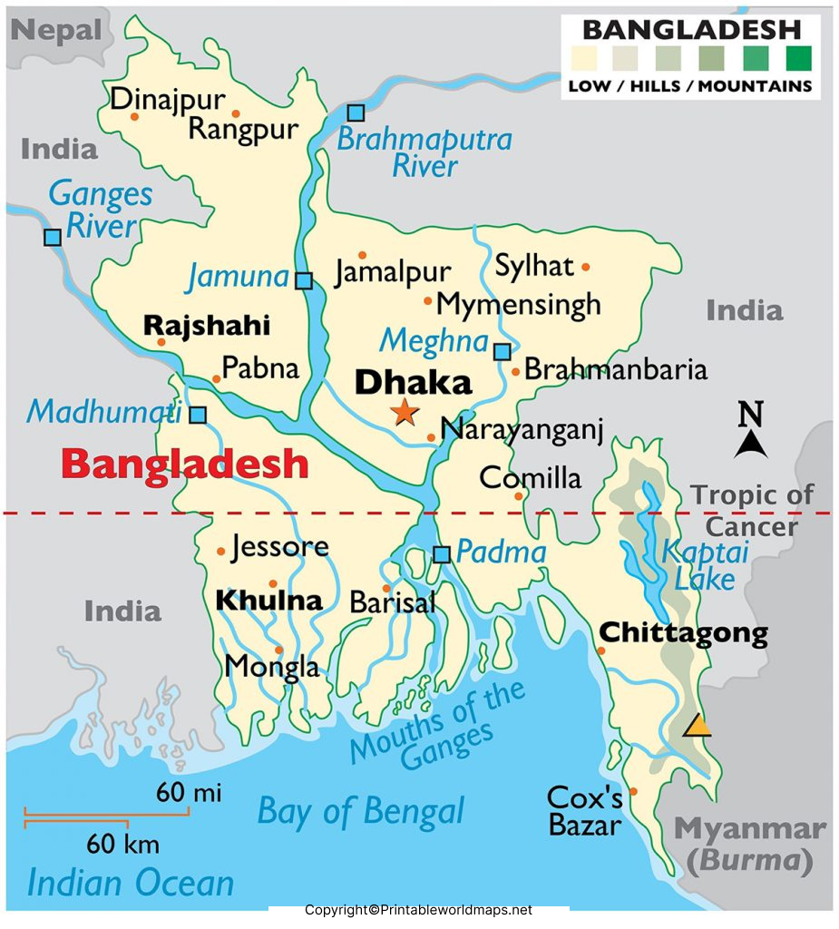
Bangladesh Geography: Key Facts
Here are some useful geographic facts to add context to the Labeled Map of Bangladesh:
- Region: South Asia
- Capital: Dhaka
- Official language: Bengali (Bangla)
- Currency: Bangladeshi taka (BDT)
- Land borders: India and Myanmar
- Southern coastline: Bay of Bengal
- Administrative divisions: 8
- Districts: 64
- Major river systems: Ganges/Padma, Brahmaputra/Jamuna, and Meghna
- Largest mangrove forest: The Sundarbans, shared geographically by Bangladesh and India
- Major port city: Chattogram
For current population, administrative, geographic, and statistical information, it is better to reference authoritative sources rather than retain the outdated 2021 population figure in the original article.
Why Use a Labeled Map of Bangladesh?
A labeled map can be useful for:
- School and geography projects
- Classroom teaching
- Learning Bangladesh’s divisions and cities
- Locating Dhaka and other major cities
- Understanding Bangladesh’s neighboring countries
- Travel and geographic reference
- Printing for educational use
- Research and presentations
Bangladesh Administrative Divisions
Bangladesh’s eight divisions provide the country’s main administrative framework. Each division contains multiple districts.
| Division | Administrative Center |
|---|---|
| Barishal | Barishal |
| Chattogram | Chattogram |
| Dhaka | Dhaka |
| Khulna | Khulna |
| Mymensingh | Mymensingh |
| Rajshahi | Rajshahi |
| Rangpur | Rangpur |
| Sylhet | Sylhet |
This structure makes a Bangladesh map with divisions particularly useful when studying the country’s administrative geography.
Interesting Facts About Bangladesh
Chattogram is an important maritime and commercial center.
Bangladesh is located in South Asia.
The country has a coastline along the Bay of Bengal.
Dhaka is the national capital.
Bangladesh has 8 administrative divisions and 64 districts.
The country is part of the extensive Ganges-Brahmaputra-Meghna delta system.
The Sundarbans is one of the world’s largest contiguous mangrove forests.
Bengali (Bangla) is the official language.
Bangladesh shares land borders with India and Myanmar.
The country’s geography is strongly influenced by rivers, floodplains, and deltaic landscapes.
Frequently Asked Questions
What is the capital of Bangladesh?
Dhaka is the capital city of Bangladesh.
How many divisions are there in Bangladesh?
Bangladesh has 8 administrative divisions.
How many districts are there in Bangladesh?
Bangladesh has 64 districts.
Does Bangladesh have states?
Bangladesh does not officially organize its first-level administrative structure into states. It has 8 divisions, which are further divided into districts.
What are the major cities shown on a Bangladesh map?
Major cities include Dhaka, Chattogram, Khulna, Rajshahi, Sylhet, Rangpur, Mymensingh, Barishal, Gazipur, and Narayanganj.
Which countries border Bangladesh?
Bangladesh shares land borders with India and Myanmar. Its southern coastline is along the Bay of Bengal.
What are the major rivers of Bangladesh?
The major river systems include the Ganges/Padma, Brahmaputra/Jamuna, and Meghna.
Can I print the Bangladesh map?
Yes. The page provides PNG map images and PDF versions that can be used as printable geographic references.
Where is Dhaka located?
Dhaka is located in central Bangladesh, along the Buriganga River and within the wider Ganges-Brahmaputra-Meghna delta region.
Reference Links
https://www.cia.gov/the-world-factbook/countries/bangladesh









