

The World Hurricane Map helps readers explore hurricane-prone ocean regions, understand tropical cyclone patterns, and locate printable world hurricane maps for educational and planning purposes. You can view the maps below, download the available PDF versions, and use trusted weather resources to check current storm activity.
World Hurricane Map
Use this world hurricane map to explore the geographic areas where tropical cyclones may develop. The map is suitable for educational projects, geography lessons, weather awareness, and general reference.

A hurricane is a rotating tropical cyclone that develops over warm tropical or subtropical waters. In the Atlantic and northeastern Pacific, a tropical cyclone is classified as a hurricane when its maximum sustained winds reach at least 74 mph (119 km/h). Similar storms are called typhoons or cyclones in other parts of the world.
Printable World Hurricane Map
A printable world hurricane map provides a convenient way to study storm-prone regions without needing an interactive map. Students, teachers, travelers, and geography enthusiasts can use a printed copy for classroom activities, research, and general reference.
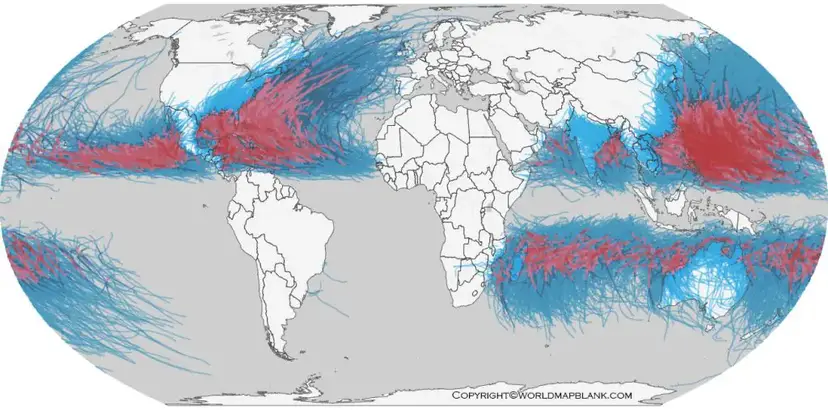
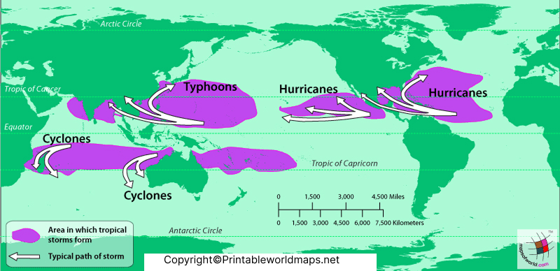
Tropical cyclones can develop in several ocean basins, including the North Atlantic, northeastern Pacific, northwestern Pacific, North Indian Ocean, and southern Indian Ocean and Pacific regions. The terminology differs by location: storms are commonly called hurricanes in the Atlantic and northeastern Pacific, typhoons in the northwestern Pacific, and cyclones in the North Indian Ocean.
The distribution and timing of these storms vary by ocean basin and season. A printable map helps explain their geographic distribution, but historical storm patterns cannot predict the exact path or impact of a future storm.
Hurricane Map of the World
The hurricane map of the world provides a broad geographic view of ocean regions affected by tropical cyclones. Areas around the Caribbean Sea, Gulf of Mexico, western Pacific Ocean, Bay of Bengal, and Arabian Sea have experienced tropical cyclone activity.
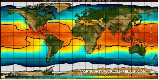
The United States, China, Japan, the Philippines, Bangladesh, India, and other coastal countries have experienced tropical cyclones, although the frequency, intensity, and hazards differ by region. These countries should not be treated as having identical hurricane risks.
If you live in or plan to visit a coastal or low-lying area, use the map as a geographic reference and check your local weather agency for current alerts. Storm surge, heavy rainfall, inland flooding, and strong winds can affect communities far from the storm’s center.
Current World Hurricane Map and Live Tracking
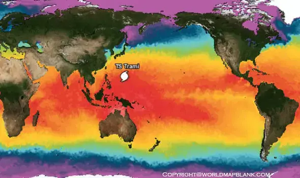
A current world hurricane map should be checked alongside reliable, regularly updated weather information. The printable map provided on this page is a reference resource; it should not be considered a live hurricane tracker unless it is connected to a verified, continuously updated data source.
For active storms, forecast tracks, storm intensity, and official warnings, visit the National Hurricane Center. For tropical cyclone information in other parts of the world, consult the relevant national meteorological agency or the World Meteorological Organization.
When checking a live tracker, look at the report’s update time, the storm’s current position, the forecast cone, and any active watches or warnings. Forecast paths are estimates, not exact boundaries of potential impacts. Dangerous weather can occur outside a forecast track, so always follow local official guidance.
World Map of Hurricane-Prone Areas
A world map of hurricane-prone areas helps readers understand where tropical cyclones commonly occur. The map is particularly useful for learning about ocean basins, comparing regional storm patterns, and identifying areas where additional weather research may be helpful.
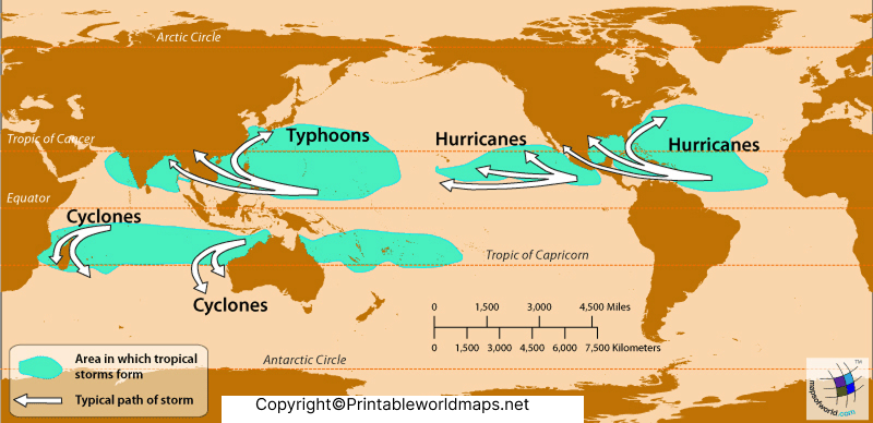
Tropical cyclones need favorable environmental conditions to form and strengthen. Warm ocean water, sufficient atmospheric moisture, and suitable wind conditions can support their development. However, not every tropical disturbance becomes a hurricane, and storm formation cannot be predicted from a static map alone.
Seven Useful Facts About World Hurricanes
- Different regional names: Hurricanes, typhoons, and cyclones are different regional names for related types of tropical cyclones.
- Wind-speed threshold: In hurricane-classification regions, sustained winds of at least 74 mph (119 km/h) mark hurricane strength.
- Several ocean basins: Tropical cyclones occur in multiple ocean basins, not just the Atlantic Ocean.
- Regional seasons vary: The timing and duration of tropical cyclone seasons differ across ocean basins.
- More than wind: Storm surge, rainfall flooding, and tornadoes can create serious hazards in addition to damaging winds.
- Forecasts change: Storm positions and projected paths are updated as new observations and forecast information become available.
- Preparation matters: Knowing evacuation routes, preparing emergency supplies, and following official warnings can help people respond to a storm.
Hurricane Categories and Wind Speeds
The Saffir-Simpson Hurricane Wind Scale classifies hurricanes from Category 1 to Category 5 based on maximum sustained wind speed.
| Category | Sustained wind speed |
|---|---|
| Category 1 | 74–95 mph |
| Category 2 | 96–110 mph |
| Category 3 | 111–129 mph |
| Category 4 | 130–156 mph |
| Category 5 | 157 mph or higher |
These thresholds use the US hurricane wind-scale standard. The categories describe wind intensity, not the complete risk from a storm. A lower-category hurricane can still cause deadly flooding or storm surge.
How to Use and Print a World Hurricane Map
- Choose the world hurricane map image or PDF provided above.
- Open the image or download the PDF to your device.
- Select the print option and use a suitable paper size and orientation.
- Check that map labels and geographic details remain readable.
- Use the map for education and reference, then consult official live tracking services when current storm information is needed.
The printable maps on this page are intended for general reference. Check the individual file before printing to confirm its resolution, labels, and suitability for your intended use.
Frequently Asked Questions About the World Hurricane Map
What is a world hurricane map?
A world hurricane map shows the geographic distribution of hurricane-prone ocean regions and may help readers understand where tropical cyclones occur. A static map does not necessarily provide current storm positions or forecasts.
Where can I download a printable world hurricane map?
You can download the PDF provided in the World Hurricane Map section or use the printable map links on this page.
Does this world hurricane map show live storms?
The printable maps listed here are reference images and PDFs. For current storm positions, forecast tracks, and official alerts, use the National Hurricane Center or the appropriate regional weather agency.
Which regions experience tropical cyclones?
Tropical cyclones occur in several ocean basins, including the Atlantic, Pacific, Indian Ocean, and South Pacific. The terminology and seasonal patterns vary by region.
What is the difference between a hurricane, typhoon, and cyclone?
These terms describe related tropical cyclone systems but are used in different geographic regions. Hurricanes occur in the Atlantic and northeastern Pacific, typhoons in the northwestern Pacific, and cyclones in regions including the North Indian Ocean.
What wind speed makes a storm a hurricane?
In the Atlantic and northeastern Pacific classification regions, a tropical cyclone becomes a hurricane when its maximum sustained winds reach 74 mph (119 km/h).
Are hurricane categories enough to determine danger?
No. The Saffir-Simpson scale measures wind intensity. Flooding, storm surge, tornadoes, local terrain, and the storm’s size can also affect risk.
How can I stay safe during a hurricane?
Follow official weather alerts, prepare emergency supplies, know your evacuation route, avoid floodwater, and follow local emergency instructions. Do not rely on a printable map alone for safety decisions.
Reference links
1. NOAA – What Is a Hurricane? https://oceanservice.noaa.gov/facts/hurricane.html
2. National Hurricane Center – Current Storms https://www.nhc.noaa.gov/
3. National Hurricane Center – Saffir-Simpson Hurricane Wind Scale https://www.nhc.noaa.gov/aboutsshws.php
4. National Hurricane Center – Hurricane Preparedness https://www.nhc.noaa.gov/prepare/
5. World Meteorological Organization – Tropical Cyclone Climatology https://public.wmo.int/resources/wmo-fact-sheets/tropical-cyclone-climatology
6. NOAA – Understanding Hurricane Hazards https://www.noaa.gov/explainers/explainer-understanding-hurricane-hazards









